
| Location: | Richneck Plantation, Williamsburg, VA, United States |
|---|---|
| Occupation Dates: | Phasing and mean ceramic dates can be found on the Chronology page. |
| Excavator(s): | Maria Franklin (68AL) and Anna Agbe-Davies (68AP). |
| Dates excavated: | AL: 1994-1995 and AP: 1995. |

68AL Overview
In 1993, the Colonial Williamsburg Foundation’s (CWF) Department of Archaeological Research (DAR) conducted an archaeological assessment of a tract of land slated for a housing development known as Holly Hills (Muraca 1993; McFaden and Muraca 1994). The Holly Hills tract was once part of Middle Plantation, the 17th-century settlement which was the precursor to Williamsburg. The shovel-test survey was part of a larger DAR project focused on the 17th-century component of Rich Neck plantation (site 44WB52; McFaden et al. 1999). Rich Neck was once the homestead of Virginia’s most prominent colonists, including Secretary of the State

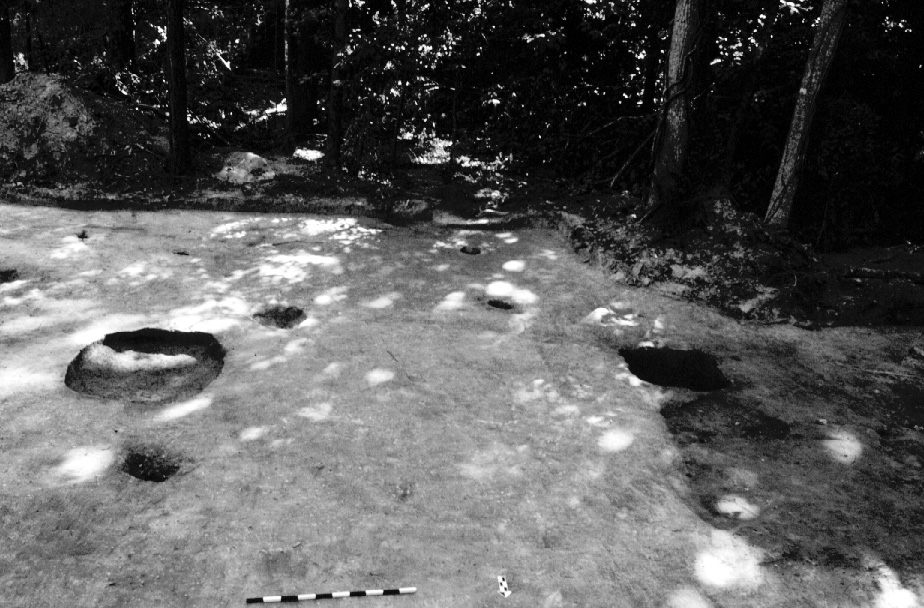
Overview of Richneck Slave Quarter site.
Thomas Ludwell. The 1993 survey revealed an 18th-century site consisting of artifact scatters, a series of below-ground features, and the remains of a brick chimney foundation approximately 100 feet north of the Kemp/Lunsford/Ludwell plantation home site. This site pre-dated the probable, 19th-century slave-related site excavated by the DAR in 1990 less than 300 feet away (Samford 1991).
68AL Documentary Evidence
Given the prominence of the Ludwell family and its connection to the Lee family of Virginia, a wealth of primary and secondary sources exist relating to the Ludwell-Lees. These include documents associated with the ownership and management of Rich Neck plantation and the enslaved families owned by the Ludwells.

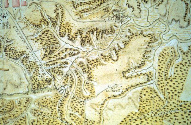
Portion of Desandrouins map showing the location of Ludwell property.
Primary Sources There are at least two probate inventories associated with Rich Neck plantation. Phillip Ludwell III’s 1767 probate inventory (transcribed in VMHB 1913) and his will (transcribed in VHM 1911; McGhan 1982: 652-653) date to the period of occupation of the Rich Neck dwelling (c. 1740-1778). Ludwell III’s inventory accounts for nine working plantations, including Rich Neck and Greenspring (the home plantation), and 235 enslaved blacks (21 of whom resided at Rich Neck). Rich Neck was then inherited by Ludwell III’s daughter, Lucy Ludwell Paradise. Before she died in 1814, an inventory of her estate was taken in January of 1812 (VHS 1812). In addition to listing the contents of Paradise’s three properties (which included Rich Neck and Chippokes plantations, and a house in Williamsburg), the names of enslaved individuals as well as their ages are given. A collection of letters penned by William Lee includes correspondence regarding the management of the Ludwell family plantations and the enslaved work force from 1766-1783 (Ford 1968). There are also two important collections of wills, letters, estate and legal documents, etc., pertaining to the Lee and Ludwell families at the Colonial Williamsburg Foundation Library (Ludwell Papers, 1678-1828), and the Virginia Historical Society (Lee Family Papers, 1638-1867). There are two historic drawings of Rich Neck plantation dating to the third quarter of the 18th-century. The first is a land plat drawn in 1770 by surveyor Wm. Goodall (Goodall 1770). It indicates that the tract consisted of 3865 acres. The survey was likely commissioned by the trustees of Ludwell III’s property as a means to facilitate the execution of his will. The second document is a military map of Williamsburg (Desandrouins 1781) and the surrounding environ completed in 1781 by a French officer by the name of Desandrouins. Rich Neck is labeled simply “M Ludwell”. A path leading to Jamestown Road is lined with four to five structures. These were probably a combination of slave dwellings and storage buildings. “Ludwell’s mill”, located at the intersection of Jamestown Road and College Creek, was used either for timber or grain. Secondary Sources A number of individual and family biographies exist relating to the proprietors of Rich Neck (including the Ludwells) from the 17th- to the 19th-centuries (Jester and Hiden 1987; Nugent 1979; WMQ 1910:208-214). In Archibald Bolling Shepperson’s (1942) book, “John Paradise and Lucy Ludwell”, the author discusses the Ludwell family history and their plantation affairs (including mention of Rich Neck) at length.
68AL Excavation History
During the 1993 field season, the DAR conducted a shovel-test survey which lead to the discovery of the Rich Neck Slave Quarter (McFaden and Muraca 1994). A portion of a feature was found and excavators shoveled the overlying plowzone to expose it. As additional features appeared, shovel-shaving continued following the features rather than the established gridlines. Once the footprint of the dwelling was revealed, two below-ground features were cross-sectioned (contexts 501 and 683). The site was backfilled until June 1994 when full-scale excavations proceeded. The 1993 backfill was first removed in quadrants (contexts 1-4) using shovels. Plowzone was removed using 1x2m (n=1), 1x1m (n=12), and 2x2m (n=15) excavation units. Most of the 1994 excavation units were dug in order to remove plowzone remaining in units from the 1993 season. All of the excavation units were shovel-shaved to subsoil and 100% of the dirt was dry-screened using ¼” screens (Franklin 2004).
| Feature Description | Master Context | Associated Contexts |
|---|---|---|
| Sub-floor pit | 5 | 61, 64, 90, 92, 97, 103, 105, 110, 111 (cut for 110), 112,113, 119, 117, 121, 122,134-137,145 (cut for 135), 149 (feature cut) |
| Sub-floor pit | 6 | 25, 63, 73, 99,101 ,501, 1241, 1243, 1245, 1247, 1249, 1251, 27 (feature cut) |
| Sub-floor pit | 7 | 126, 128, 141, 161, 129 (feature cut) |
| Sub-floor pit | 8 | 29, 30 (feature cut) |
| Sub-floor pit | 9 | 31, 32 (feature cut) |
| Sub-floor pit | 10 | 34, 36, 37, 109,123, 127,132,133, 35 (feature cut) |
| Sub-floor pit | 11 | 44, 53, 120, 683, 684 (feature cut) |
| Sub-floor pit | 14 | 49, 71, 158, 185 (feature cut) |
| Sub-floor pit | 15 | 66, 91, 100,102, 67 (feature cut) |
| Sub-floor pit | 16 | 83, 84 (feature cut) |
| Sub-floor pit | 17 | 49, 144, 168 (feature cut) |
| Sub-floor pit | 18 | 47, 51, 146, 52 (feature cut) |
| Sub-floor pit | 19 | 21, 22 (feature cut) |
| Sub-floor pit | 20 | 93, 95, 94 (feature cut) |
| Sub-floor pit | 21 | 42, 68, 86, 130, 162, 163, 164, 165, 166, 169-173, 176, 181, 184 (feature cut) |
| Chimney | 23 | 57, 59, 179, 196, 58 (feature cut) |
| Hearth/firebox | 12 | 125, 125, 197 |
| Robber’s trench | 24 | 55, 56 (feature cut) |
| Unidentified feature | 14, 15 (feature cut) | |
| Unidentified feature | 16, 17 (feature cut) | |
| Unidentified feature | 40, 41 (feature cut) | |
| Unidentified feature | 74, 75 (feature cut) | |
| Unidentified feature | 115 | |
| Unidentified feature | 118, 143 (feature cut) | |
| Unidentified feature | 152, 153 (feature cut) | |
| Unidentified feature | 156, 157 (feature cut) | |
| Unidentified feature | 174, 175, 186 (feature cut) | |
| Tree hole | 107, 108 (feature cut) | |
| Tree hole | 150 | |
| Tree hole | 154, 155 (feature cut) | |
| Tree disturbance | 1256 | |
| Rodent burrow | 177, 178 (feature cut) |
The research design included an intensive, flotation sampling program: all of the major pit features and the robber’s trench were hand-trowelled and 100% of the excavated fills were collected for flotation. Thousands of faunal fragments (Franklin 2001) were recovered as well as charred seeds and numerous small finds. A shovel-test survey was also undertaken in 1994. The 1993 survey generally placed shovel tests at ten-meter intervals. The 1994 survey collapsed the intervals by placing shovel tests at five meter intervals. Thirty-nine shovel tests (contexts 6000-6039) were excavated and dry-screened. Results of SURFER analysis indicated that refuse was broadcast northwest and west of the dwelling, and may have been swept periodically away from the frontal approach of the house (Agbe-Davies 1994). These results were further supported by the higher artifact concentrations within excavation units in the same area relative to those both south and west of the house. A concentration of artifacts just east of the dwelling was further investigated by establishing a 5x5m unit (context 76) over the area and piece-plotting artifacts from the ground surface to 10cm below grade. Three 1x1m units (contexts 138-140) were then excavated within the 5x5m unit, but no features were discovered. One of the shovel tests (context 6025), however, did hit a feature. A 1x1m unit (context 160) was dug adjacent to the shovel test which led to the discovery of site 68AP (c. 1710-1740s).
68AL Summary of Research
Based on the archaeological remains, historical evidence, and comparisons with research findings of other 18th-century, Chesapeake slave housing, the RNSQ dwelling was likely a wooden, double-pen residence with an internal wall and dirt floor. It measured approximately 20’ wide and 30’ long. Given the gender and age demographics of the enslaved Rich Neck community (Ludwell probate inventory), two families probably shared the structure, each with its own residence (Franklin 2004).
Ceramic and tobacco pipe stem data helped to establish an occupation span of c. 1740s-1778. Virginia half-pennies minted in 1773 were recovered from several pits backfilled during the latter stage of occupation. Documentary sources reveal a possible explanation. In 1778, William Lee learned that the Paradises, who owned a large portion of Rich Neck, which likely included the quarter, had been abandoned by all of the enslaved, save for one (Shepperson 1942:136). Governor Dunmore had decreed that any slaves escaping to the British who were willing to fight the rebels would be freed (Kulikoff 1986:418–419; Mullin 1972:130–136). As many as 70 enslaved individuals fled Greenspring that same year as well.
RNSQ site phasing consisted of determining the life cycle of the house and its related features from initial construction to post-abandonment (see Table 2). Six phases were determined based upon the depositional histories of each feature (as determined using ceramic crossmend data, TPQs for each context, and the sequence of backfill for each feature) and the relationships between features.
Table 2: Rich Neck Slave Quarter site phasing. The TPQs given for Phases I-IV are based upon the most recent TPQ established for a particular context assigned for each phase.
| Phase I: Initial Construction of House (c. 1740) | ||
|---|---|---|
| Master Context | Context Numbers Associated with Phase I | |
| 23 | 57, 59, 179, 196, 58 (builder’s trench cut) | |
| Phase II: Root Cellar Activities (tpq 1745) | ||
| Master Context | Context Numbers Associated with Phase II | |
| 5 | 134, 135 (145 cut), 137, 149 (feature cut) | |
| 8 | 29, 30 (feature cut) | |
| 10 | 35 (feature cut) | |
| 14 | 71, 158, 185 (feature cut) | |
| 17 | 144, 186 (feature cut) | |
| 14 and 17 | 49 (redeposited sub backfill) | |
| 19 | 21, 22 (feature cut) | |
| 21 | 169, 170, 171, 172, 173, 176, 181, 184 (feature cut) | |
| Phase III: Root Cellar Activities (tpq 1765) | ||
| Master Context | Context Numbers Associated with Phase III | |
| 5 | 90, 92, 97, 105, 117, 103, 110 (111 cut), 112, 119, 121, 122, 136 | |
| 10 | 133 | |
| 15 | 100, 102, 67 (feature cut) | |
| 16 | 84 (feature cut) | |
| Phase IV: Root Cellar Activities (tpq 1773) | ||
| Master Context | Context Numbers Associated with Phase IV | |
| 5 | 61, 64 | |
| 6 | 27, 73, 99, 101 | |
| 7 | 129 (feature cut) | |
| 9 | 32 (feature cut) | |
| 10 | 34, 36, 37, 109, 123, 127, 132 | |
| 11 | 120, 684 (feature cut) | |
| 18 | 47, 51, 146, 52 (feature cut) | |
| 20 | 94 (feature cut) | |
| 21 | 42, 68, 86, 130, 162, 163, 164, 165, 166 | |
| Phase V: Final Backfilling of Features and House Abandonment (c. 1773-1778) | ||
| Master Context | Context Numbers Associated with Phase V | |
| 6 | 25, 63, 501, 1241, 1243, 1245, 1247, 1249, 1251 | |
| 7 | 126, 128, 141, 161 | |
| 9 | 31 | |
| 11 | 44, 53, 683 | |
| 15 | 66, 91 | |
| 16 | 83 | |
| 20 | 93, 95 | |
| Phase VI: Post-Abandonment Activities (post-1778) | ||
| Master Context | Context Numbers Associated with Phase VI | |
| 24 | 55, 56 (feature cut) |
Most of the artifacts recovered from the sub-floor pits constituted secondary depositions. The ceramic crossmend evidence indicated that individuals collected backfill dirt largely from the midden northwest and west of the house (see above discussion under “Excavation history”). Since residents in both halves of the house probably used the same area for refuse disposal and the retrieval of backfill for defunct root cellars, it was impossible to compare the two households using archaeological evidence. However, given the depositional history of the root cellars, it is possible to analyze the data diachronically as representative of both households over time.
The majority of the historic artifacts constituted the architectural materials associated with the dwelling (nails, window glass, etc.) and domestic debris commonly found on household-related sites (ceramics, wine bottle glass, table glass, etc.). The artifacts represented not only household activities such as foodways and sewing, but objects related to clothing and personal adornment, home furnishings, hygiene practices, and medicinal usage were also present. A variety of woodworking tools such as hammers and chisels were recovered. Hilling hoes and sickles were token reminders of the daily toil of Rich Neck’s enslaved community.
Faunal analysis revealed that this community actively participated in subsistence practices to supplement their food rations (Franklin 1997; 2001). A wide variety of fish (including catfish, herring, and perch), wild mammals (including raccoon, rabbit, and opossum), birds (Canadian goose, chicken, and turkey), and oysters were consumed. Personal garden plots were probably allowed based upon the botanical evidence. Beans, cowpeas, and squash were identified, as well as various grains including barley, wheat, and rye. Foraging for foodstuffs was also indicated by the presence of honey locust, black walnut, acorn, and blackberry seeds.
Maria Franklin
Colonial Williamsburg Foundation
December 2003
68AP Overview
Overview of Richneck Slave Quarter site.
In 1994, in the process of conducting a test pit survey on the periphery of the Rich Neck Slave Quarter (68AL), Colonial Williamsburg archaeologists Ywone Edwards, Maria Franklin, and Anna Agbe-Davies identified a large artifact-filled feature. Subsequent excavation revealed a small cellar and another associated feature that bridged the years between the 17th-century manor complex and the later 18th-century quarter. These features were designated 68AP, the “small cellar” site.
Analysis focused on the two primary artifact-bearing features, approximately 3 meters apart. The smaller pit, designated “M3,” was sub-rectangular and quite shallow with a carefully dug flat bottom. This pit contained only one depositional layer with a terminus post quem of 1755. The cellar, designated “feature 1,” was dug straight into the clay subsoil with no evidence of a lining or architectural elements that would hint at the nature of the superstructure above. Based on tpqs, the initial filling of the cellar dates no earlier than the 1730s, with the uppermost layers dating to 1745 or later.
The cellar is the only remaining evidence of the structure that stood in the early 18th-century. After abandonment, the empty cellar was exposed for a brief period of time, during which intermittent and random filling occurred. The second quarter of the 18th-century saw at least two episodes of rapid intentional filling, perhaps close together in time, but from different primary deposits. The filling dates overlap with the earlier end of the date range of the nearby Rich Neck Slave Quarter (68AL). Indeed, the filling of “feature 1,” may relate to the initial occupation and use of that later dwelling.
68AP Documentary Evidence
Very little documentation exists for the occupation represented by “feature 1” and “M3”. An inventory taken in 1767 lists occupants, tools, and livestock for a quarter on Rich Neck plantation (Virginia Magazine of History and Biography (VMHB) 1913). However, given the date, the inventory probably refers to the Rich Neck Slave Quarter (68AL).
The Rich Neck plantation ceased to be the Ludwell family seat in the first decade of the 18th-century. Early 18th-century owner Philip Ludwell II lived several miles away at Greenspring, as did his son Philip Ludwell III, who inherited his father’s holdings in 1727/6. There is no evidence that anyone other than an enslaved work force resided at Rich Neck after ca. 1706. All of the available references to plantation managers and occupants date to the years Philip III spent in England before his death sometime in the 1760s (Smith 1993). Although these texts refer to a time after the abandonment of the structure represented by “feature 1”, Agbe-Davies (1999:32) has speculated that the filling of “feature 1” may be part of a reorganization of Philip III’s holdings upon his departure for England prior to 1760. Please see the Rich Neck Plantation history for further information.
68AP Excavation History
The defining feature of this site—its small, unlined cellar—was first identified in 1994 during a phase II survey of the area surrounding the Rich Neck Slave Quarter. The close (5 meter) interval of the survey ensured that one of the 75 x 75 cm test units would overlay the small cellar.
In early 1995, the area around “feature 1,” was machine-stripped, exposing the approximately 4 x 4 meter extent of the cellar, and another feature (M3), that was, in size (1.2 x 1.6 meters) and shape (sub-rectangular), not unlike the sub-floor pits identified at the Rich Neck Slave Quarter, roughly 15 meters to the northwest. At this time, archaeologist Dwayne Pickett and his crew sampled a 1 x 1 meter column of the cellar to a depth of 70 cm, using arbitrary levels and screening all deposits.
In the summer of 1995, a larger area (approximately 15 x 13 meters) was machine-stripped in an attempt to identify foundations or postholes associated with the cellar prior to full-scale excavation supervised by Anna Agbe-Davies. Further clearing of the plowzone revealed a sloping entrance to the cellar at its western edge. The plowzone was not screened, aside from the 2.25% sample recovered by the initial test pit survey.
All of the features uncovered were excavated using trowels and screened through ¼ inch mesh, with the exception of subsoil erosion layers in the cellar, which were not screened. Excavators collected flotation and chemical samples, including a 25 x 25 cm column sample through the fill layers of the cellar. This column sample was processed, but not analyzed. Other samples include oyster shell and brick.
None of the irregularly-shaped features appeared to be cultural, so excavation and analysis focused on the cellar, “feature 1”, and “M3.” The cellar was excavated in quadrants, leaving the southwest quadrant (largely obscured by the root system of a large tree) in place. The fill of the cellar extended 1.3 meters below subsoil at its deepest point, and was composed of four major depositional episodes interspersed with erosion layers of displaced subsoil, indicating exposure to the elements. A Harris Matrix illustrates the depositional sequence and correlates the deposits in the three quadrants.
68AP Summary of Research
In an analysis of the survey that revealed the small early- to mid-18th-century cellar at Rich Neck (feature 1) Agbe-Davies (1994) noted that plowzone artifact concentrations were not a reliable predictor of sub-surface features. A crossmending study confirmed that the major fill layers in “feature 1” were discrete depositional events (Agbe-Davies 1997). Crossmends also revealed only one direct link between sealed contexts from 68AP (master context M6) and a feature from the Rich Neck Slave Quarter, root cellar 5. Non-contiguous vessel fragments linked M4 with root cellars 10, 15, and 21, and reinforced the association between M6 and root cellar 5. All of these root cellar features are among the earliest subfloor pits from the Slave Quarter site (Franklin 1997).
The resulting ceramic vessels and their functions are discussed in detail in the site report by Agbe-Davies (1999). However, a comparison of vessel forms with contemporary sites (quarter and non-quarter) revealed no clear patterns.
The site report also includes a discussion of the faunal material recovered from the uppermost fill deposit from “feature 1”. Biomass measures reveal that over 3/4 of the potential meat at the site would have come from cattle, pigs, sheep/goat, and unidentifiable large and medium mammals, with cattle forming the largest share. Similar rankings were suggested by the meat weight calculations.
A detailed assessment of the site formation processes that contributed to the development of “feature 1” concluded that it did not represent the demolition of the overlying structure, but rather intermittent discard of household debris, probably from the Rich Neck Slave Quarter, interspersed with brief erosion episodes (Agbe-Davies 1999:32).
Anna Agbe-Davies
Colonial Williamsburg Foundation
December 2003
Things you need to know about the Richneck Slave Quarter site before you use the data:
- The two structures on this site, 68AL and 68AP, were excavated over two different seasons by two different principal investigators.
- Measurements are in meters and centimeters.
Feature Numbers
The original excavators of the Rich Neck AP and AL sites did not assign numbers to individual features. DAACS staff has assigned feature numbers using the original excavation records. Feature Numbers assigned by DAACS have a F-prefix, which precedes the number (i.e. F01 equals Feature 1).
Excavated contexts that belong to the same depositional basin (e.g. a posthole and postmold or the layers in a single pit) have been assigned a single feature number. In addition, single contexts have been given feature numbers when the original field records indicate that the excavators recognized a context’s spatial distinctiveness from surrounding contexts.
Feature Groups
Feature groups are sets of features whose spatial arrangements indicate they were part of a single structure (e.g. structural postholes, subfloor pits, and hearth) or landscape element (e.g. postholes that comprise a fenceline). Feature Groups assigned by DAACS have a FG-prefix, which precedes the number (i.e. FG01 equals Feature Group 1).
| Feature | Feature Type | Contexts |
|---|---|---|
| F05 | Pit, subfloor(< 28 sq.ft) | AC01245, AL00061, AL00064, AL00097 |
| F05a | Pit, subfloor(< 28 sq.ft) | AL00090, AL00092, AL00105, AL00117, AL00119, AL00134, AL00135, AL00149 |
| F05b | Pit, subfloor(< 28 sq.ft) | AL00121, AL00122, AL00103, AL00120, AL00136, AL00137 |
| F05c | Pit, subfloor(< 28 sq.ft) | |
| F06 | Pit, subfloor(< 28 sq.ft) | AC01247, AC01249, AC01241, AC01243, AL00101, AL00025, AL00063, AL00027, AL00073 |
| F07 | Pit, subfloor(< 28 sq.ft) | AL00128, AL00129, AL00161, AL00126, AL00141 |
| F08 | Pit, subfloor(< 28 sq.ft) | AL00029, AL00030 |
| F09 | Pit, subfloor(< 28 sq.ft) | AL00031, AL00032 |
| F10 | Pit, subfloor(< 28 sq.ft) | AC01251, AL00123, AL00127, AL00132, AL00133, AL00034, AL00035, AL00036, AL00037, AL00109 |
| F11 | Pit, subfloor(< 28 sq.ft) | AL00044, AL00053 |
| F12 | Burned Subsoil | AL00125, AL00124 |
| F13 | Burned Subsoil | AL00197 |
| F14 | Pit, subfloor(< 28 sq.ft) | AL00158, AL00185, AL00071 |
| F15 | Pit, subfloor(< 28 sq.ft) | AL00102, AL00066, AL00067, AL00091, AL00100 |
| F16 | Pit, subfloor(< 28 sq.ft) | AL00083, AL00084 |
| F17 | Pit, subfloor(< 28 sq.ft) | AL00144, AL00168 |
| F18 | Pit, subfloor(< 28 sq.ft) | AL00047, AL00051, AL00052, AL00146 |
| F19 | Pit, subfloor(< 28 sq.ft) | AL00021, AL00022 |
| F20 | Pit, subfloor(< 28 sq.ft) | AL00093, AL00094, AL00095 |
| F21 | Pit, subfloor(< 28 sq.ft) | AL00166, AL00042, AL00068, AL00086, AL00162, AL00163, AL00164, AL00165, AL00169, AL00170, AL00171, AL00172, AL00184, AL00130 |
| F21a | Pit, subfloor(< 28 sq.ft) | AL00173, AL00176, AL00181 |
| F22 | Animal Hole | AL00177, AL00178 |
| F23 | Chimney Base | AL00057, AL00058, AL00059, AL00179, AL00196, AL00110, AL00112 |
| F24 | Trench, robber’s | AL00055, AL00056 |
| Feature | Feature Type | Contexts |
|---|---|---|
| F01 | Cellar | AP00044, AP00045, AP00046, AP00047, AP00048, AP00049, AP00063, AP00064, AP00065, AP00072, AP00069, AP00070, AP00073, AP00074, AP00078, AP00083, AP00084, AP00085, AP00087, AP00088, AP00089, AP00090, AP00091, AP00042, AP00002, AP00005, AP00007, AP00009, AP00031, AP00035, AP00036, AP00041, AP00043, AP00082, AP00051, AP00052, AP00054, AP00057, AP00055, AP00058, AP00061, AP00062, AP00066, AP00068, AP00075, AP00076, AP00077, AP00001, AP00067, AP00086, AP00006, AP00008, AP00037, AP00080, AP00079, AP00071, AP00081 |
| F03 | Pit, subfloor(< 28 sq.ft) | AP00003, AP00004, AP00032 |
Seriation Method
This page summarizes a preliminary frequency-seriation based chronology for the Rich Neck site that was developed by DAACS (see Neiman, Galle, and Wheeler 2003 for technical details). The chronology is preliminary because DAACS is still missing a small amount of fieldwork documentation from the site. It is unlikely that this documentation will substantially alter the results presented here.
DAACS seriated ceramic assemblages, with more than 5 sherds, from individual excavated contexts and from stratigraphic groups — groups of contexts that field records indicate were part of a single stratigraphic layer or deposit. Stratigraphic groups have a SG-prefix, which precedes the group number (e.g. SG01 equals Stratigraphic Group 1). For example, at the Rich Neck site, two portions of the fill in the builder’s trench for the brick hearth (F23) were excavated as contexts AL00057 and AL00179. These were both assigned to SG10. Not all contexts have stratigraphic group assignments.
DAACS chose to base the seriation chronology for Rich Neck on ceramic assemblages aggregated at the level of contexts and stratigraphic groups, and not at the level of features. Many of the features on the site are subfloor pits, each of which has multiple layers. Basing the seriation on individual layers, rather than combining all the layers in a given pit or feature, makes it possible to discover multiple filling episodes, distributed widely across time for a single pit.
DAACS computed the frequency of mean-ceramic-date (MCD) types in stratigraphic groups and individual contexts, when those contexts had no stratigraphic group assignment. The seriation chronology is derived from a correspondence analysis of these MCD-type frequencies. Seriated assemblages were assigned to phases. Phases are groups of assemblages that have similar correspondence-analysis scores and are therefore inferred to be broadly contemporary. Phases assigned by DAACS have a P-prefix that precedes the phase number (e.g. P01 equals Phase 1).
The stratigraphic relationships among stratigraphic groups and unassigned contexts are summarized in the Harris Matrix for the site. Once they are available, final phase assignments from the seriation will be shown on the Harris Matrix in color, facilitating comparison of the seriation chronology and the stratigraphic chronology of the site.
Rich Neck Site Phases
Based on the correspondence analysis, DAACS divided the occupation of Rich Neck into three phases. The ceramic assemblage from four contexts emerged in the correspondence analysis as outliers in relation to the other assemblages, signaling their distinctive composition, and justifying their placement in Phase 1. All four contexts are associated with subfloor pits under the western structure. Three of these contexts (AL00090, AL00105, and AL00134) comprise the bottom layer in a large subfloor pit (F05) in front of the hearth. The fourth (AL00133) is the bottom layer in a second subfloor pit (F10). Phase 1 appears to date to the second quarter of the 18th-century, despite its relatively late mean ceramic date.
Phase 2 includes all three stratigraphic groups associated with the eastern structure on the site: SG12 and SG13, within the large pit (F01), and SG14 within the subfloor pit (F03). It also includes many layers within the multiple subfloor pits associated with the western structure. Based on MCD and TPQ estimates, Phase 2 probably dates to the 1750’s and 1760’s.
Phase 3 dates to the 1760’s and the early 1770’s and includes subfloor pit layers that were deposited shortly before the site was abandoned.
| Phase | MCD | TPQ | TPQp90 | Total Count |
|---|---|---|---|---|
| P01 | 1761 | 1720 | 1700 | 164 |
| P02 | 1756 | 1762 | 1700 | 1353 |
| P03 | 1761 | 1765 | 1762 | 443 |
This three-phase chronology suggests the following hypothesis about the occupational history of the site. The fact that the western structure is aligned perpendicular to and centered on the gable of the eastern structure hints they stood at the same time. The multiple subfloor pits indicate the western structure was a slave house. Could the eastern building have been an original overseer’s house, which was abandoned by Phase 2 and became a convenient receptacle for trash from the western structure?
A Seriation Chronology for the Rich Neck Site
The following table presents a seriation chronology for the Rich Neck site. We use the indefinite article to signify that it is not the only chronology possible, nor even the best one possible. DAACS encourages users of Archive data to help explore improvements.
Rich Neck Harris Matrix
The Harris Matrix summarizes stratigraphic relationships among excavated contexts and groups of contexts that DAACS staff has identified as part of the same stratigraphic group. Stratigraphic groups and contexts are represented as boxes, while lines connecting them represent temporal relationships implied by the site’s stratification, as recorded by the site’s excavators (Harris 1979).
Stratigraphic groups, which represent multiple contexts, are identified on the diagram by their numeric designations (e.g. SG03), followed by the description (e.g. “Subfloor Pit, layer 1”). Contexts that could not be assigned to stratigraphic groups are identified by their individual context numbers (e.g. AL00058).
Boxes with color fill represent contexts and stratigraphic groups with ceramic assemblages large enough to be included in the DAACS seriation of the site (see Chronology). Their seriation-based phase assignments are denoted by different colors, to facilitate evaluation of the agreement between the stratigraphic and seriation chronologies. Grey boxes represent contexts that were not included in the seriation because of small ceramic samples.
This Harris Matrix is based on data on stratigraphic relationships recorded among contexts in the DAACS database. It was drawn with the ArchEd application. See http://www.ads.tuwien.ac.at/arched/index.html.
See the Richneck Chronology for stratigraphic and phase information.
For a printable version, download the Harris Matrix [113.52 KB PDF].

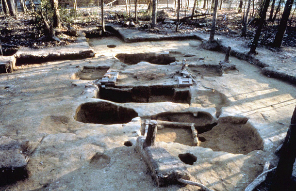

Composite excavator’s plan compiled by DAACS from original field drawings.
Appraisement of the Estate of Philip Ludwell Esqr, Decd.
1913 Virginia Magazine of History and Biography XXI(1): 395-416.
Inventory of the Estate of Lucy L. Paradise.
1812 The Virginia Historical Society, Mss1-L51 f204-205 Section 98 and C227 f72-73.
Lee Family Papers, 1638-1867.
Manuscripts, Mss1 L51. Virginia Historical Society, Richmond, Virginia.
Ludwell Family., William and Mary Quarterly
1911 William and Mary Quarterly, 1st series, 19(3): 199-214.
Ludwell Papers, 1678-1828 (1879).
Microfilm, Special Collections, Colonial Williamsburg Foundation Library, Colonial Williamsburg Foundation, Williamsburg, Virginia.
Virginia Gleanings in England.
1911 Virginia Historical Magazine, Dec. 3, XIX: 288-289.
Agbe-Davies, Anna
1994a Artifact Distributions and Spatial Patterning at the Rich Neck Slave Quarter. Paper presented at the annual meeting of the Council for Northeast Historical Archaeology, Williamsburg, Virginia.
Agbe-Davies, Anna
1994b Preliminary Findings from the Rich Neck Slave Quarter Excavations. Paper presented at the annual meeting of the Council for Northeast Historical Archaeology, Williamsburg, Virginia.
Agbe-Davies, Anna
1997 An Analysis of Several Enigmatic Features from the Rich Neck Plantation Site. Paper presented at the annual meeting of the Society for Historical Archaeology, Corpus Christi, Texas.
Agbe-Davies, Anna
1999 Archaeological Excavation of a Small Cellar on Rich Neck Plantation. Report on file at the Department of Archaeological Research, Colonial Williamsburg Foundation, Williamsburg, Virginia.
Desandrouins, Jean-Nicolas
1781 Map of the Environs of Williamsburg, in Virginia. Oversize MP/00/1781/61.222. Colonial Williamsburg Foundation Library, Colonial Williamsburg Foundation, Williamsburg, Virginia.
Ford, Worthington Chauncey
1968 Letters of William Lee, 1766-1783. Burt Franklin, New York, New York.
Franklin, Maria
1997 Out of Site, Out of Mind: The Archaeology of an Enslaved Virginian Household, ca. 1740-1778. Ph.D. dissertation, University of California, Berkeley, California. University Microfilms, Ann Arbor, Michigan.
Franklin, Maria
2004 An Archaeological Study of the Rich Neck Slave Quarter and Enslaved Domestic Life. Colonial Williamsburg Foundation, Williamsburg, Virginia.
Goodall, William
1770 Rich Neck plat. Oversized map collection, 01/1770/63.20. Colonial Williamsburg Foundation Library, Colonial Williamsburg Foundation, Williamsburg, Virginia.
Harris, Edward C.
1979 Principles of Archaeological Stratigraphy. Academic Press, London, England.
Jester, Annie Lash, and Martha Woodroof Hiden
1987 Adventurers of Purse and Person VIRGINIA 1607-1624/5. Third edition, revised and edited by Virginia M. Meyer and John Frederick Dorman. The Dietz Press, Inc; Richmond, Virginia.
McFaden, Leslie , Jennifer Jones , David Muraca , and Philip Levy
1999 Interim Report: The Archaeology of Rich Neck Plantation, VDHR File Number 97-1411-F. Report on file at the Department of Archaeological Research, Colonial Williamsburg Foundation, Williamsburg, Virginia.
McFaden, Leslie , and David Muraca
1994 Archaeological Testing at Holly Hills. Report on file at the Department of Archaeological Research, Colonial Williamsburg Foundation, Williamsburg, Virginia.
McGhan, Judith
1982 Virginia Will Records. Genealogical Publishing Co., Inc., Baltimore, Maryland.
Mullin, Gerald W.
1972 Flight and Rebellion: Slave Resistance in Eighteenth-Century Virginia. Oxford University Press, New York.
Muraca, David
1993 Archaeological Testing at Rich Neck. Report on file at the Department of Archaeological Research, Colonial Williamsburg Foundation, Williamsburg, Virginia.
Nugent, Nell Marion
1979 Cavaliers and Pioneers: Abstracts of Virginia Land Patents and Grants, 1623-1666, Volume I. Virginia Book Company, Berryville, Virginia.
Samford, Patricia
1991 Archaeological Investigations of a Probable Slave Quarter at Rich Neck Plantation, 44WB52. Report on file at the Department of Archaeological Research, Colonial Williamsburg Foundation, Williamsburg, Virginia.
Shepperson, Archibald Bolling
1942 John Paradise and Lucy Ludwell of London and Williamsburg. The Dietz Press, Richmond, Virginia.
Smith, F. H.
1993 Eighteenth-Century History of the Ludwell Family at Rich Neck Plantation in Williamsburg, Virginia. Department of Archaeological Research, Colonial Williamsburg Foundation, Williamsburg, Virginia.
Walsh, Lorena S.
1993 Slave Life, Slave Society, and Tobacco Production in the Tidewater Chesapeake, 1620-1820., Cultivation and Culture In Cultivation and Culture, edited by Ira Berlin and Phillip D. Morgan, pp. 170-199. University Press of Virginia, Charlottesville, Virginia.