| Location: | Curriboo, Berkeley County, South Carolina, United States |
|---|---|
| Occupation Dates: | Second-quarter 18th century to circa 1800. Phasing and mean ceramic dates can be found on the Chronology page. |
| Excavator(s): | Soil Systems, Inc. |
| Dates excavated: | 1979. |

Overview
In 1979, Soil Systems Inc. embarked on a groundbreaking project resulting in the earliest and most extensively excavated slave-related sites in the southeast. Project Investigators Pat Garrow and Tom Wheaton headed mitigation fieldwork in advance of the U.S. Army Corps of Engineers’ Cooper River Rediversion Canal Project. The archaeological component, known as The Cooper River Historic Sites Investigation, included surface collection, metal detector survey, mechanical stripping, and excavation, and focused most intensively on three sites containing slave quarters: Yaughan 75 and Yaughan 76 both located on Yaughan Plantation; and Curriboo 245, located on Curriboo Plantation.
Curriboo 245 is located between Lake Moultrie and the Santee River near the town of St. Stephens, South Carolina in Berkeley County. It is located three-quarters of a mile from Yaughan 75 and Yaughan 76 and the same distance from the river. The site consisted of multiple slave dwellings and plantation outbuildings belonging to the Curriboo plantation, an indigo and rice plantation owned by Huguenots and was occupied from the 1740s to shortly after 1800 (Wheaton and Garrow 243).
Structures 245C1 and 245C2, looking southeast.
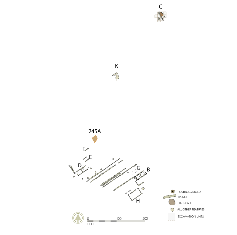
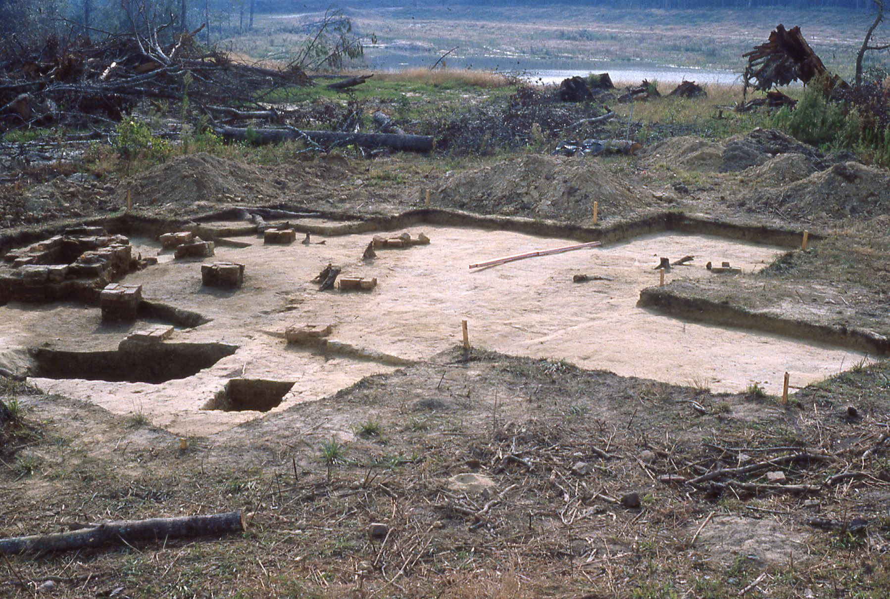
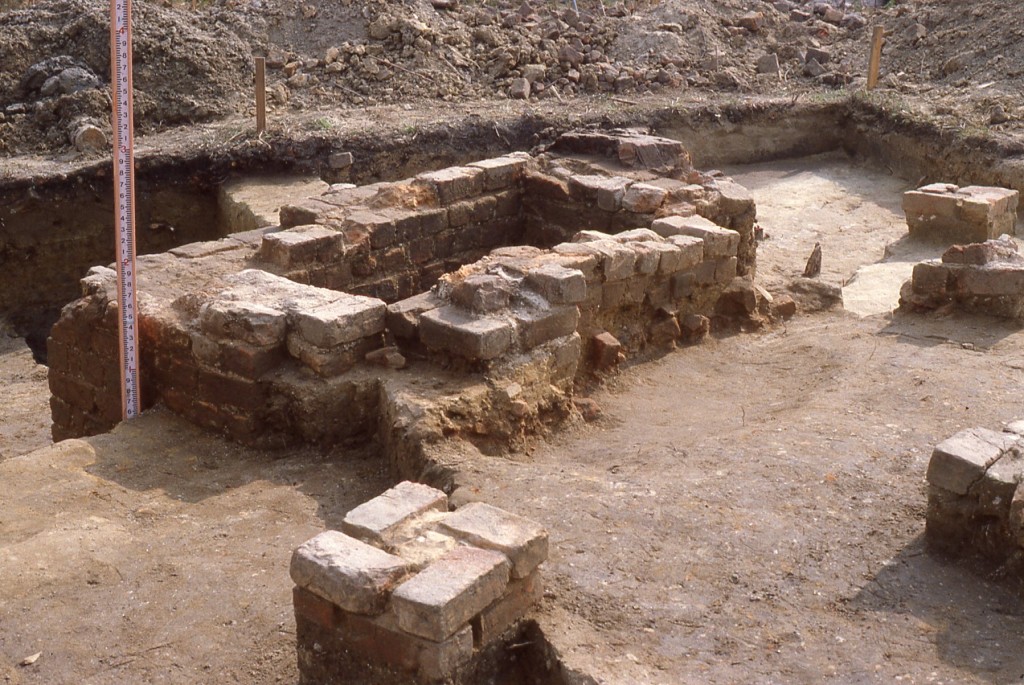
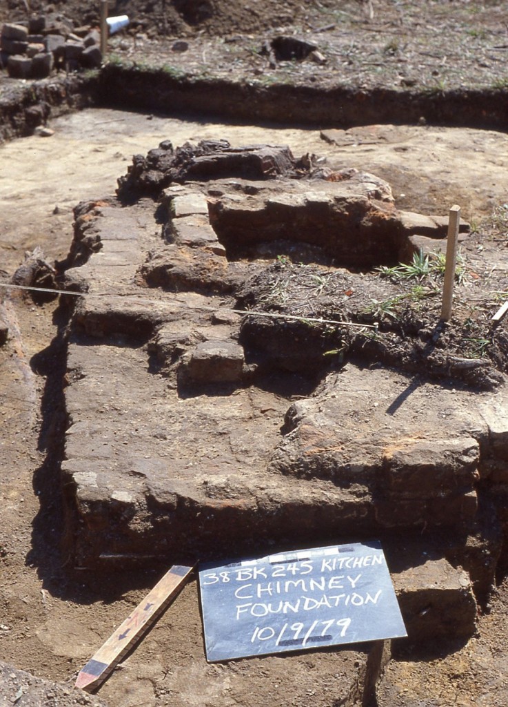
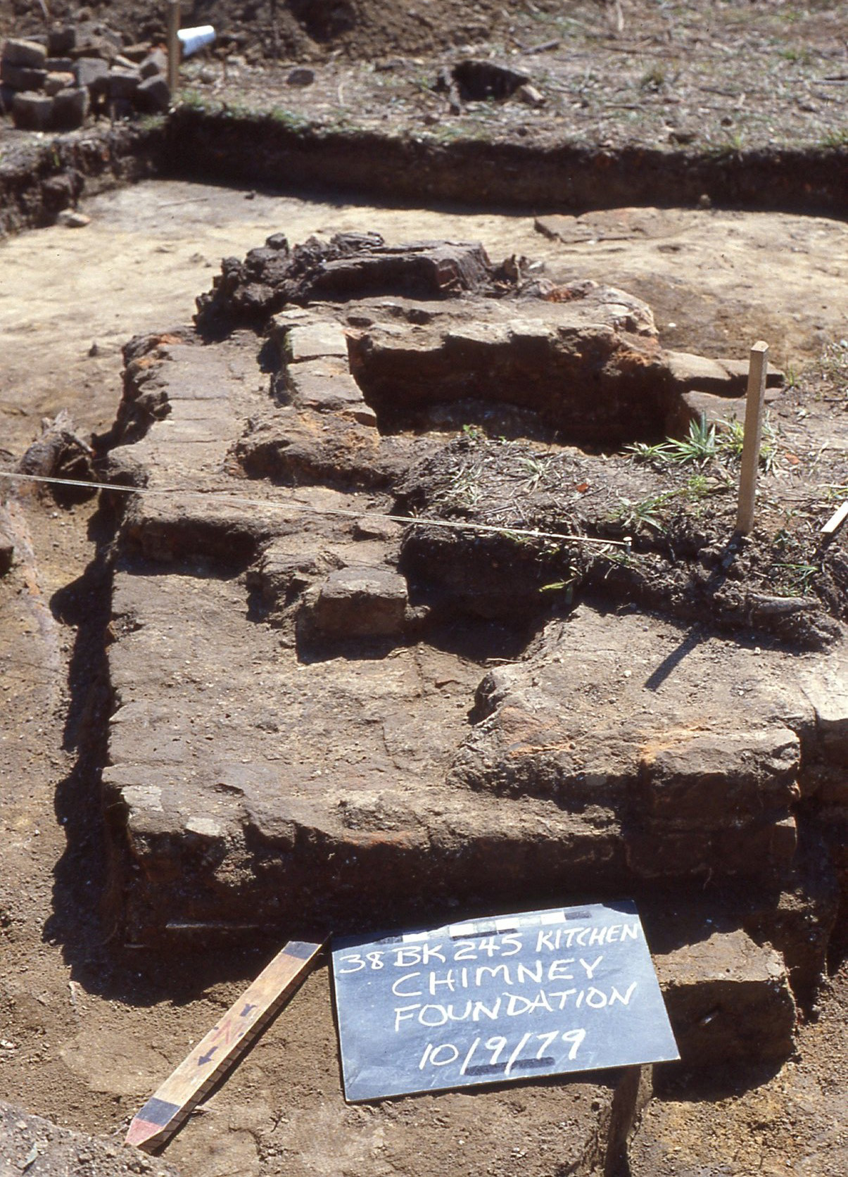
Curriboo 245 was heavily impacted by mechanical stripping prior to mitigation. Eleven structures were identified at the site. An excavation block was opened to expose a brick-piered structure (Structure 245C1, a possible overseer’s house) which was discovered to overlie an earlier trench structure (Structure 245C2) with an associated cellar. A separate cellar (245A) was excavated but was severely damaged and no remnants of an associated structure were present. In addition, a severely damaged brick clamp (245K) was recorded (Wheaton et. al. 98 and 191). Several features that are interpreted as irrigation channels or ditches were also excavated in the southern area of the site. The most significant artifact type recovered was colonoware, which composed over fifty percent of the artifact assemblage (Wheaton and Garrow 248).
Documentary evidence
The histories of Curriboo and Yaughan Plantations are related. When Samuel Thomas sold Yaughan to Isaac Cordes in 1742, the description of the 650-acre tract referred to lands southeast of Yaughan “belonging to Isaac and Thomas Cordes” (Deed Book R-5 : 187 ). This is probably Curriboo, which Isaac Cordes and his brother Thomas, known as “Colonel Thomas Cordes”, had acquired from Ellery or his estate.
A 1745 inventory of Isaac Cordes’ personal property lists slaves, livestock and “Sundries at Correboo [sic] between Coll Thomas Cordes and the Estate” (Inventory of Isaac Cordes, 9 August 1745, pp. 328-330). Although earlier references to the ownership of this plantation were oblique, the Cordes brothers had acquired Curriboo by 1745. Thomas Cordes died in 1748 and willed Curriboo, then consisting of 1390 acres, to his second son Samuel. Between 1745 and 1748, Thomas Cordes severed the relationship between Curriboo and his brother’s estate, and his branch of the family became the sole occupants and owners of the plantation.
Samuel Cordes bequeathed Curriboo to his eldest son Thomas (d. 1799) in 1796. Thomas Cordes, also known as Thomas Cordes, Jr., to distinguish him from his cousin Thomas Cordes (d. 1806) who then resided at Yaughan, willed three plantations including Curriboo to his only son James Jamieson Cordes, only one year old at the time of his father’s death in 1799. He appears to have been brought up in Charleston primarily, and in 1845, he and his brothers in-law, who were his attorneys, sold the 2,255- acre Curriboo Plantation to Charles Macbeth. Four years later, Macbeth sold the entire tract to Robert Press Smith, who then began to divide the plantation.
Excavation history, procedure, and methods
There was no pre-mitigation testing at 38BK245. The importance of the site was not recognized until it had been heavily damaged by the excavation of a large borrow pit by Corps contractors (Wheaton et. al. 71). Topsoil was stripped before mitigation could be conducted by archaeologists (Wheaton et. al. 92). Controlled surface collections were made during the mitigation phase as there was no testing phase (Wheaton et. al. 89). A 50 by 50 ft grid was set up across the site and artifacts were intensively collected within each 50 ft square (Wheaton et. al. 92).

Structure 245K, Feature 1, looking west.
Following surface collection, the entire gridded area was mechanically cleared and shovel shaved to expose any features. Artifacts recovered during stripping were added to the general artifact collection for the site (Wheaton et. al. 93).
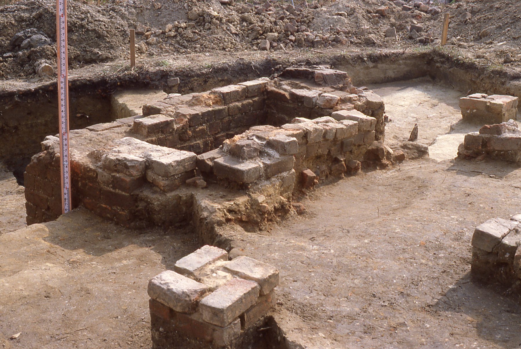
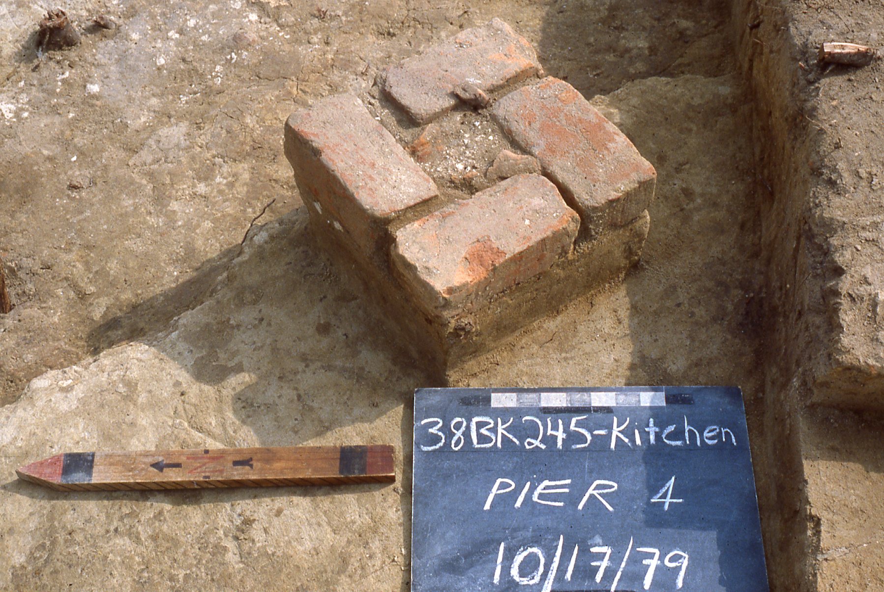
A 30 by 30 ft block was placed to investigate a surface brick feature and associated structure (Structure 245C1). The block was hand excavated in ten foot units with 6-inch baulks (Wheaton et. al. 92). It was discovered that this structure directly overlaid an earlier one (Structure 245C2). Nine or ten brick piers associated with C1 rested on and were aligned with the trenches of C2. Structure C2 had an associated cellar that was sectioned and the northeast and northwest quadrants were excavated.
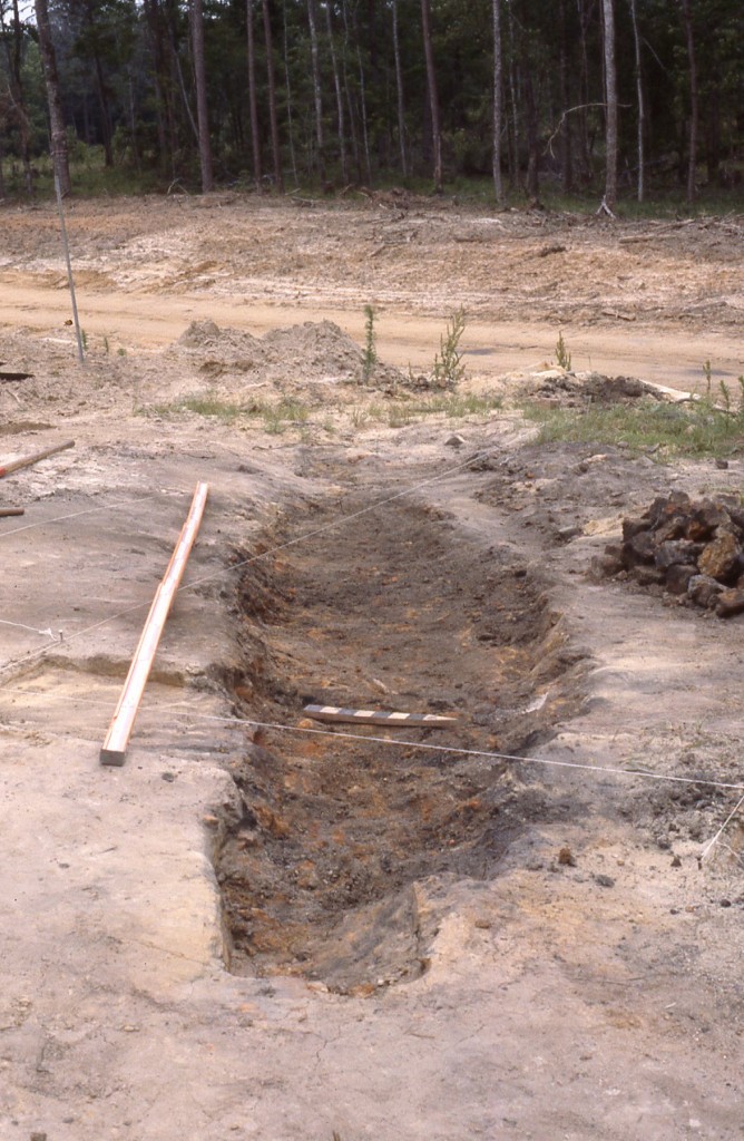
In addition to the block excavation at 245C, a brick clamp (245K) and a cellar (245A) were also hand excavated. The cellar was quartered first, then entirely excavated in natural layers to it’s sand floor. No remnants of an associated structure were found. Structure 245K, a brick clamp, had been severely impacted by construction and an attempt was made during mitigation to salvage what little remained of it. This was undertaken by trenching through its center in order to determine the deepest part of the intact feature, then dividing it into quadrants and hand excavating them.
Structures B, D, E, F, G, and H:
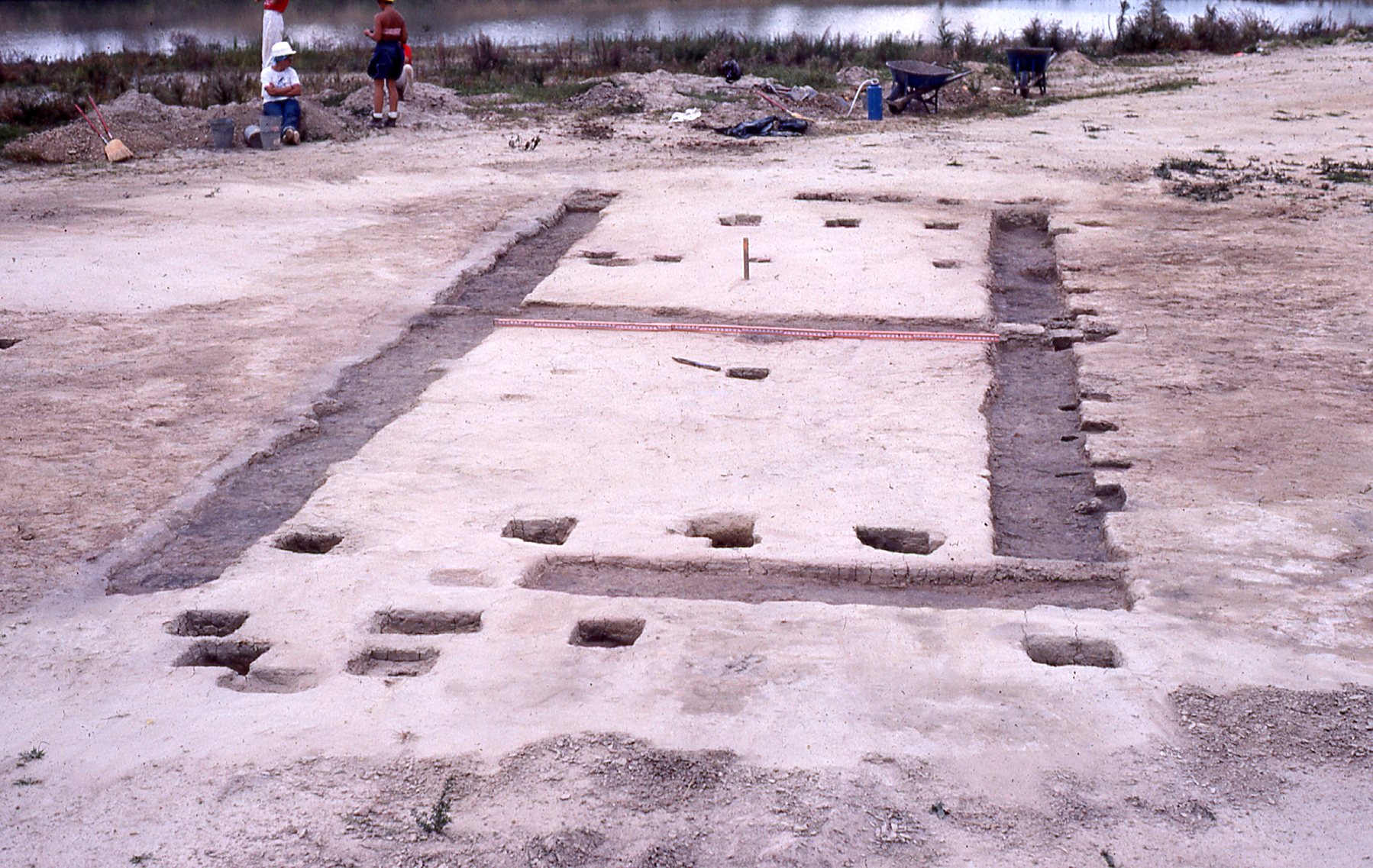
Structure 245B, looking northeast.
These are all located in the southern area of the site, in the mechanically-stripped area. Structures are all similarly oriented in a northeast/southwest direction, two of which are double-bay structures. Most of the structures and associated features were drawn and not excavated after the area was stripped
One structure, Structure B, had several features that were excavated: every isolated posthole for the structure, replacement postholes along the southeast wall, two test cross-sections of the house trenches, and two-to-three inches of the remaining trenches were excavated in order to to examine them for postmolds as complete excavation of these was not feasible.
Of note at this site were several trenches that are hypothesized to be irrigation channels or ditches. Their alignment was generally northeast-southwest. In general, five foot sections of each were excavated in order to obtain profiles and bottom depths.
Summary of research and analysis
38BK245 consisted of eleven structures: eight within the mechanically stripped area; one in the borrow pit; and two on the north edge (Wheaton et. al. 191).
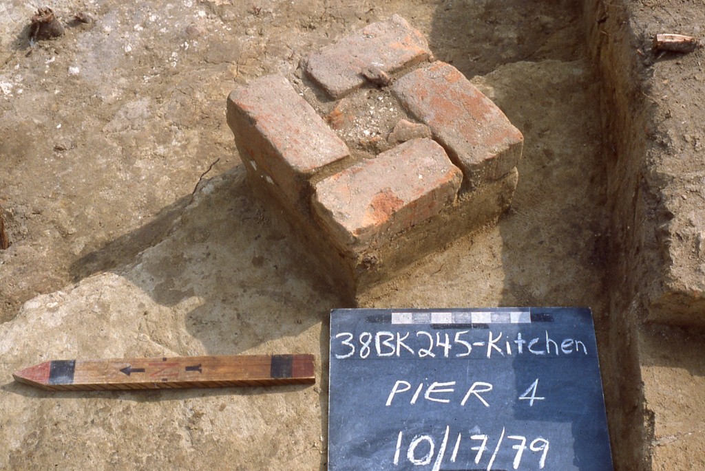
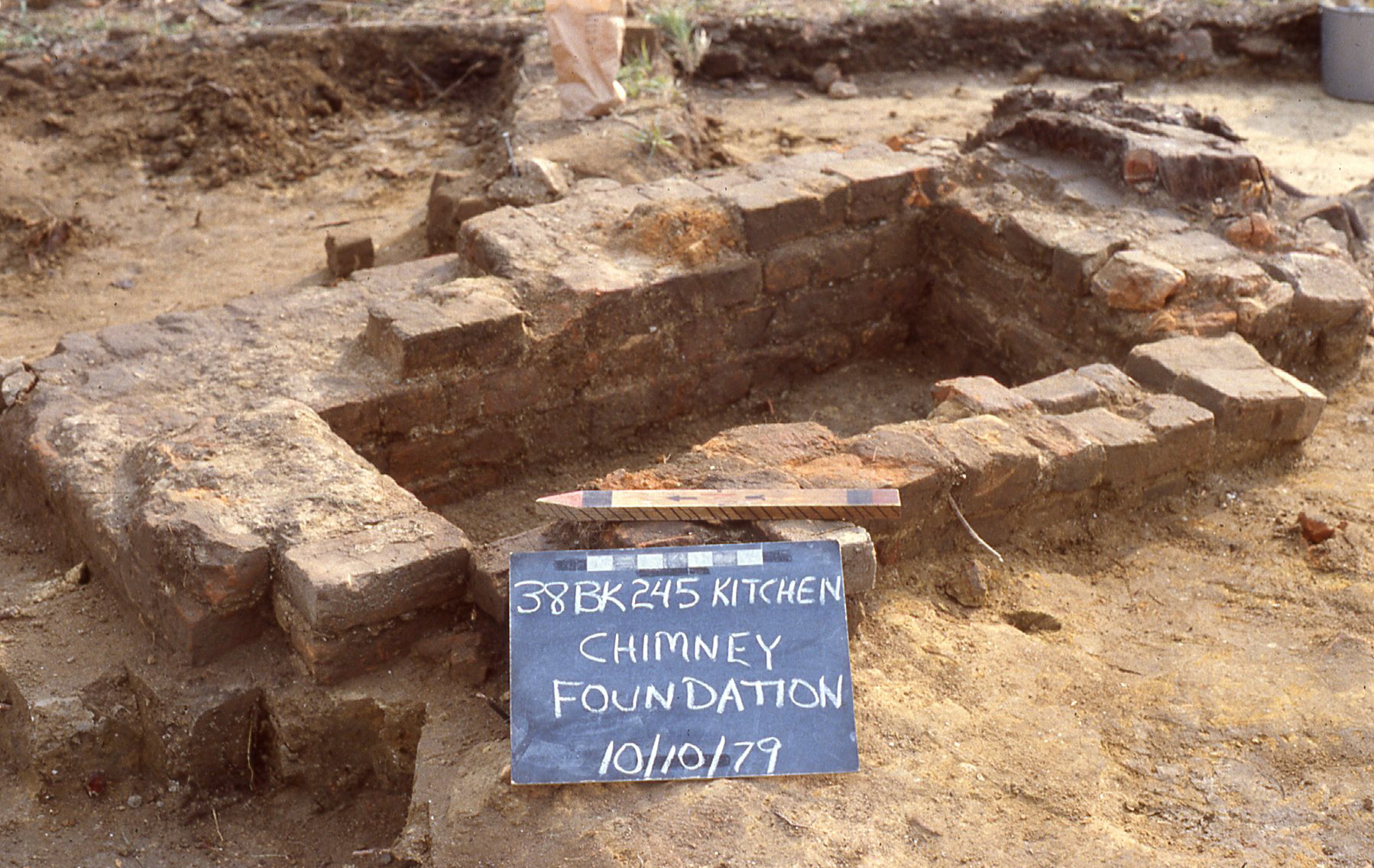
Structure 245A, was only represented by one feature, a cellar. Structure 245C was block excavated and discovered to be two structures: 245C1 and 245C2. 245C1 was built on brick piers and was the only structure with an indoor fireplace and brick chimney (Wheaton et. al. 102). It was built directly on top of 245C2, a trench structure with a cellar (Wheaton et. al. 190). Structure 245C1 likely served an administrative function, while the earlier 245C2 was interpreted by the Principal Investigators as serving a function related to the processing and housing of naval stores (Wheaton et. al. 191).
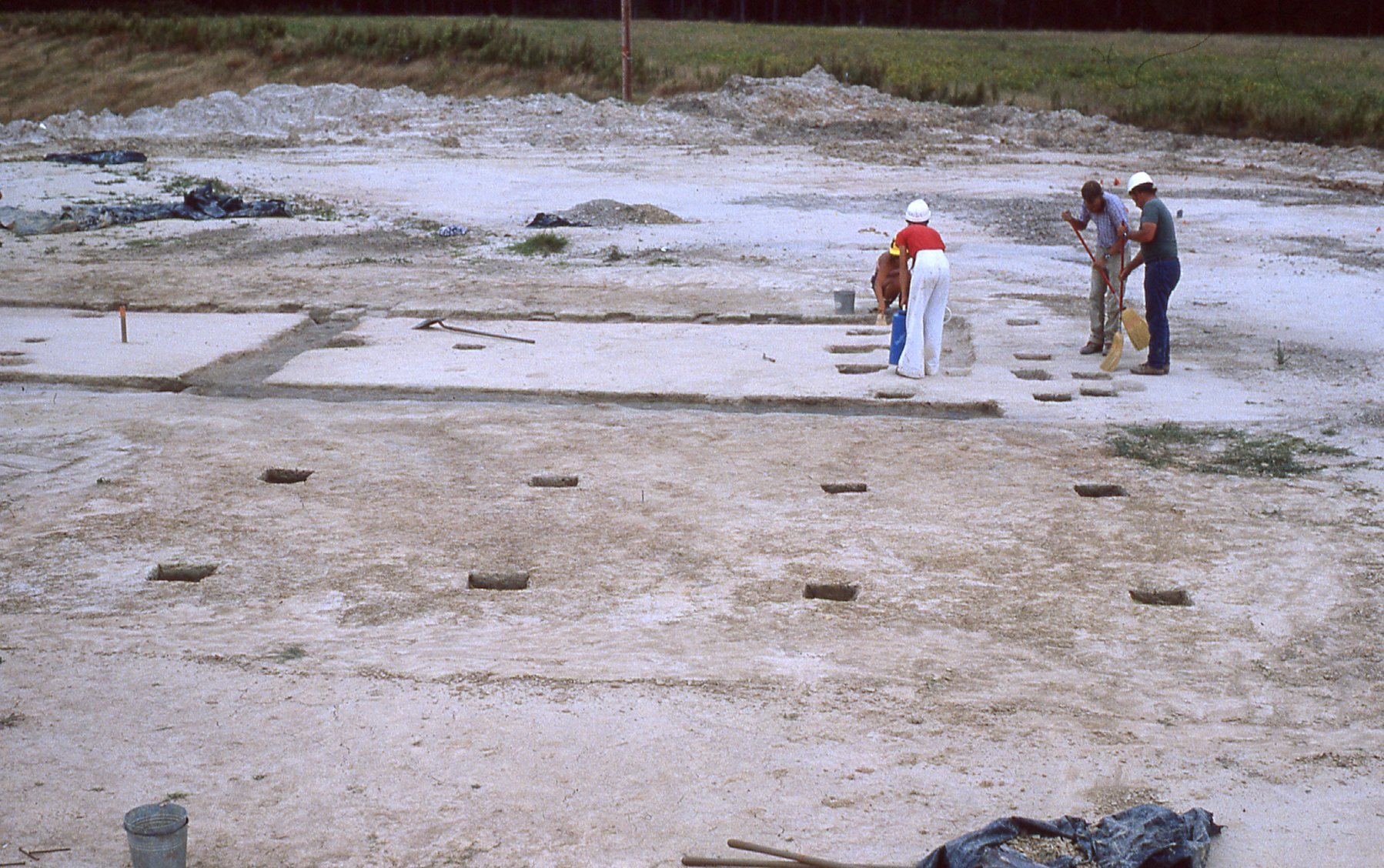
Structure 245G, looking southeast.
In addition to naval stores activity having taken place at Curriboo, the Principal Investigators hypothesized that brick was also produced at the site, evidenced by a brick clamp (Structure 245K), which was represented by a charcoal stain and scattered, broken brick due to extensive damage by the excavation of a borrow pit at its location (Wheaton et. al. 182 and 185).
Structure G was a posthole structure located northwest of Structure B. The wide spacing of posts and the fact that the northeast and southwest ends had no intermediate postholes led to the conclusion it may have served a function such as a covered work area.
Structure H, likely a barn, was the largest encountered throughout the project and was located south of Structures B and G. It had two entrances located along the side of the structure and a dirt floor.
Leslie Cooper and Jesse Sawyer
The Digital Archaeological Archive of Comparative Slavery
January 2014
- Measurements are in feet and tenths of feet
Grid information:
Spatial information recorded in individual context records and DAACS site maps for Curriboo 245 are based on the coordinate system established in the field that covers the entire site. Local grids that were established over the site were converted to the large grid as well.
Mitigation phase:
1. Surface collection was carried out over 50 x 50 ft large surface collection units. These contexts were given coordinates based on large grid.
- e.g. Contexts 245-L01 through L28
In addition, four areas were more intensively investigated and have context prefixes associated with their respective structure IDs:
2. One 30 by 30 ft block was excavated at Structure C. All contexts and features associated with Structure C will have a 245C prefix.
- e.g. Context 245C-U04: Context from Unit 04 at Structure C
- e.g. Context 245C-B01-5 Baulk context associated with Structure
3. Three more structures, 245A, 245B and 245K were more intensively investigated. Their respective contexts are as follows:
- e.g. Context prefix 245A: Contexts associated with Structure A
- e.g. Context 245K-1-1: Context from unit at Structure K
- e.g. Context 245K-F1-1: Context from Feature 1 at Structure K
- e.g. Context prefix 245B: Contexts associated with Structure B
4. Also, trenches and other features not associated with structures were investigated:
- e.g. Context 245-F03: Context from a feature at the site not associated with a structure
- The associated feature for the above context is simply F03.
5. Feature assignments for those associated with structures:
- Feature 245A A cellar feature
- e.g. Feature C-F01 A feature associated with Structure C
- e.g. Feature F01 Feature located in the general site area, not associated with a structure
- Features F11A through F11U are associated with Structure B at the site. Letter suffixes were added by DAACS to postmold features that are part of the structure and not originally assigned feature numbers in the field.
Feature Numbers
The original excavators of the Curriboo site assigned numbers to individual features. Yaughan 76 feature numbers were assigned consecutively throughout the entire project. Excavators assigned feature numbers using an F-prefix that precedes the number (i.e. F001 is Feature 1).
Feature Groups
Feature groups are sets of features whose spatial arrangements indicate they were part of a single structure (e.g. structural postholes, subfloor pits, and hearth) or landscape element (e.g. postholes that comprise a fenceline). Feature Groups assigned by DAACS have a FG-prefix, which precedes the number (i.e. FG01 equals Feature Group 1). Feature Groups were not assigned by the original excavators of Curriboo.
| Feature | Feature Type | Contexts |
|---|---|---|
| F11 | Trench, Builder’s | 245B-11-01, 245B-11-02, 245B-11-03, 245B-11-04, 245B-11-05, 245B-11-06, 245B-11-07, 245B-11-08, 245B-11-09, 245B-11-10 |
| F11A | Postmold | 245B-11-11 |
| F11B | Postmold | 245B-11-12 |
| F11C | Postmold | 245B-11-13 |
| F11D | Postmold | 245B-11-14 |
| F11E | Posthole | 245B-11-15 |
| F11F | Posthole | 245B-11-16 |
| F11FFF | Posthole | 245B-11-34 |
| F11G | Postmold | 245B-11-17 |
| F11H | Posthole | 245B-11-18 |
| F11I | Posthole | 245B-11-19 |
| F11J | Postmold | 245B-11-20 |
| F11L | Posthole | 245B-11-21, 245B-11-22 |
| F11M | Postmold | 245B-11-23 |
| F11N | Posthole | 245B-11-24 |
| F11R | Posthole | 245B-11-25, 245B-11-26 |
| F11RR | Posthole | 245B-11-33 |
| F11S | Posthole | 245B-11-27, 245B-11-28 |
| F11T | Posthole | 245B-11-29, 245B-11-30 |
| F11U | Posthole | 245B-11-31, 245B-11-32 |
| F31 | Posthole | 245-F31-1, 245-F31-2 |
| F32 | Posthole | 245-F32-1, 245-F32-2 |
| F34 | Posthole | 245-F34-1, 245-F34-2 |
| F35 | Posthole | 245-F35-1, 245-F35-2 |
| F36 | Posthole | 245-F36-1, 245-F36-2 |
| F37 | Posthole | 245-F37-1, 245-F37-2 |
| F38 | Posthole | 245-F38 |
| F40 | Posthole | 245-F40-1, 245-F40-2 |
| F41 | Posthole | 245-F41 |
| F42 | Posthole | 245-F42 |
| F46 | Posthole | 245-F46 |
| F50 | Posthole | 245-F50 |
| F51 | Posthole | 245-F51-1, 245-F51-2 |
| F52 | Posthole | 245-F52-1, 245-F52-2 |
| F53 | Posthole | 245-F53 |
| F54 | Posthole | 245-F54 |
| F55 | Posthole | 245-F55-1, 245-F55-2 |
| F56 | Posthole | 245-F56-1, 245-F56-2 |
| F57 | Posthole | 245-F57-1, 245-F57-2 |
| F58 | Posthole | 245-F58-1, 245-F58-2 |
| Feature | Feature Type | Contexts |
|---|---|---|
| F001 | Pit, unidentified | 76-F001 |
| F002 | Pit, unidentified | 76-F002-1, 76-F002-2, 76-F002-3, 76-F002-4 |
| F003 | Trench, unidentified | 76-F003-1, 76-F003-2 |
| F004 | Trench, unidentified | 76-F004 |
| F005 | Trench, unidentified | 76-F005-1, 76-F005-2 |
| F006 | Trench, unidentified | 76-F006 |
| F007 | Trench, unidentified | 76-F007 |
| F008 | Trench, unidentified | 76-F008-1, 76-F008-2, 76-F008-3, 76-F008-4 |
| F009 | Trench, unidentified | 76-F009 |
| F010 | Trench, unidentified | 76-F010 |
| F011 | Pit, unidentified | 76-F011 |
| F012 | Pit, trash | 76-F012-1, 76-F012-2 |
| F013 | Posthole | 76-F013 |
| F014 | Posthole | 76-F014-1, 76-F014-2 |
| F015 | Posthole | 76-F015-1, 76-F015-2 |
| F016 | Posthole | 76D-F16 |
| F017A | Posthole | 76D-F17-1 |
| F017B | Postmold | 76D-F17-1 |
| F018 | Posthole | 76D-F17-2 |
| F020 | Posthole | 245B-11-01 |
| F021 | Posthole | 245B-11-01 |
| F022 | Posthole | 245B-11-01 |
| F025 | Posthole | 245B-11-01 |
| F033 | Posthole | 245B-11-01 |
| F059 | Unidentified | 245B-11-01 |
| F060 | Pit, unidentified | 245B-11-01 |
| F061 | Unidentified | 245B-11-01 |
| F062 | Pit, unidentified | 245B-11-01 |
| F063 | Pit, unidentified | 245B-11-01 |
| F064 | Unidentified | 245B-11-01 |
| F065 | Pit, unidentified | 245B-11-01 |
| C-F01 | Firebox, brick | 245B-11-01 |
| C-F02 | Trench, builder’s | 245B-11-01 |
| C-F05 | Trench, builder’s | 245B-11-01 |
| C-F06 | Trench, builder’s | 245B-11-01 |
| C-F08 | Trench, builder’s | 245B-11-01 |
| K-F01 | Not a Basin/Cut | |
| 245A | Cellar | 245A-1-1, 245A-1-2, 245A-1-3, 245A-1-4, 245A-3-1, 245A-2-1, 245A-2-2, 245A-3-2, 245A-3-3, 245A-3-4, 245A-4-1, 245A-4-2, 245A-4-3, 245A-4-4, 245A-4-5, 245A-4-6, 245A-2-4, 245A-2-3, 245A-1-5, 245A-3-5, 245A-1-6 |
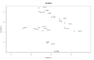
Figure 1. Plot of contexts and stratigraphic groups along CA dimensions 1 (Inertia 21%) and 2 (Inertia 19%).
Intra-site Chronologies
DAACS has developed a uniform set of methods to infer intra-site chronologies for all of the sites included in the archive. These methods, which include frequency-seriation and correspondence analysis, were developed by DAACS (see Neiman, Galle, and Wheeler 2003 for technical details). The use of common methods for all sites in the archive is designed to increase comparability among temporal phases at different sites. The methods and the phase assignments they produced are summarized below. Archive users may also use the Mean Ceramic Date queries provided on the Query the Database section of this website to calculate MCDs for individual contexts or features.
For some sites, the original excavators developed intra-site chronologies and, where these exist, they are described on the Background page for the site. In the case of Stratford Hall’s West Garden, the principal investigators did not develop a chronology for the site. The DAACS chronology presented here is the only current chronology for the site.
DAACS Seriation Method
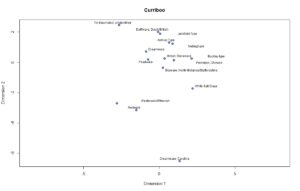
Figure 2. Plot of Ware Types along CA Dimensions 1 (Inertia 21%) and 2 (Inertia 19%).
As with other sites in the Archive, the seriation chronology for Curriboo was derived from ceramic assemblages aggregated at the level of stratigraphic groups and individual contexts not assigned to stratigraphic groups. To reduce the noise introduced by sampling error, only ceramic assemblages with more than five sherds were included. We excluded assemblages from unit clean-up and surface collections. The seriation chronology presented here is the result of a correspondence analysis (CA) of ware-type frequencies from contexts that meet these requirements (Figures 1 and 2).
After running an initial version of the CA it was determined that the only type with a nineteenth century manufacturing start date, Whiteware, had small a sample size and was distributed randomly, i.e. its distribution showed no discernable pattern. Consequently, Whiteware was removed from the CA because it was obscuring the patterning of ware types with earlier manufacturing date ranges.
Upon examination of the CA for Curriboo, it is evident there are roughly two clusters of assemblages along Dimension 2 (Figure 1), whereas Dimension 1 appears to represent more variability between assemblages than it does along the dimension axis. In addition, CA results produced a stronger correlation between Dimension 2 scores and MCDs than that seen along Dimension 1 (Figures 1 and 2), suggesting that Dimension 2 represents time from bottom (early) to top (late) along the Y axis. The CA results produced a correlation between Dimension 2 scores and MCDs (Figures 3-5), suggesting that Dimension 2 represents time. Based on the dips in ceramic counts observed in a histogram of Dimension 2 scores, where the vertical axis measures ceramic assemblage size, we divided the Curriboo site into two occupational phases (Figures 4 and 5). This pattern is different from some other sites in the archive, where CA analysis has shown that Dim 1 represents time. The Dimension 1 scores seem to be capturing variation that could be related to synchronic differences related to work areas or different functions of the site or some other unknown factor.
Site Phases
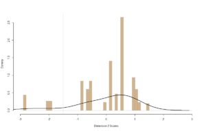
Figure 3. Histogram of ceramics from Curriboo plotted along CA Dimension 2. The vertical lines indicate DAACS phase divisions.
DAACS Phases are groups of assemblages that have similar correspondence-analysis scores, similar MCDs, or both, and are therefore inferred to be broadly contemporary. Phases have a P-prefix that precedes the phase number (e.g. P01 equals Phase 1). Based on the correspondence analysis DAACS divided the Curriboo occupation into 2 phases (Figures 4 and 5). Mean ceramic dates for the site-specific phases are given in the table below. The assemblages from the three contexts (SG12_F12, 245-L19, 245-L10) that are differentiated by the Dim 2 scores as Phase 1 are clustered in the southeastern area of the site and dominated by Carolina Creamware, Westerwald/Rhenish, and Redware. As noted above, a good portion of the assemblage came from surface collection and from postmold/posthole features. The low ceramic counts associated with individual contexts meant that only a small percentage of contexts could be included in the phasing analysis.
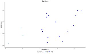
Figure 4. CA Dimension 1 scores for assemblages plotted against Mean Ceramic Dates, contexts are not labeled.
The MCDs for the two phases are given in the table below. Individual phase MCDs and BLUE MCDs, which give less influence to ceramic types with long manufacturing spans, indicate that Curriboo was occupied throughout the second half of the eighteenth century. The table also provides three TPQ estimates. The first TPQ estimate is the usual one – the maximum beginning manufacturing date among all the ware-types in the assemblage.
Two other TPQ measures included in the table below are less sensitive to excavation errors and taphonomic processes that might introduce a small amount of anomalously late material into an assemblage. They are TPQp90 and TPQp95. The TPQp95 of 1765 and 1775 for the two phases provides a robust estimate of the site’s TPQ based on the 95th percentile of the beginning manufacturing dates for all the artifacts comprising it. The TPQp90 of 1775 for all phases provides a more robust estimate of the site’s TPQ based on the 90th percentile of the beginning manufacturing dates for all the artifacts comprising it.
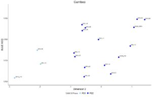
Figure 5. CA Dimension 1 scores for assemblages plotted against Mean Ceramic Dates, contexts are labeled.
Incorporating data from the DAACS database, we perform the correspondence analysis through the R programming language (R Core Team 2014) to conduct the CA analysis. The CA code was written by Fraser D. Neiman. The following packages generate the data tables, CA, and plots within this code: RPostgreSQL (Conway et al. 2013), plyr (Wickham 2014), reshape2 (Wickham 2014), seriation (Hahsler et al. 2014), ca (Greenacre, Nenadic, and Friendly 2014), and ggplot2 (Wickham 2015).
All of the R code used in this analysis was written within the domain of the R Core Team at the R Foundation for Statistical Computing, Vienna, Austria (2014). The correspondence analysis for Curriboo was conducted by Elizabeth Bollwerk.
| Phase | MCD | BlueMCD | TPQ | TPQ90 | TPQ95 | Total Count |
|---|---|---|---|---|---|---|
| P01 | 1760 | 1766 | 1775 | 1775 | 1765 | 29 |
| P02 | 1765 | 1775 | 1775 | 1775 | 1775 | 269 |
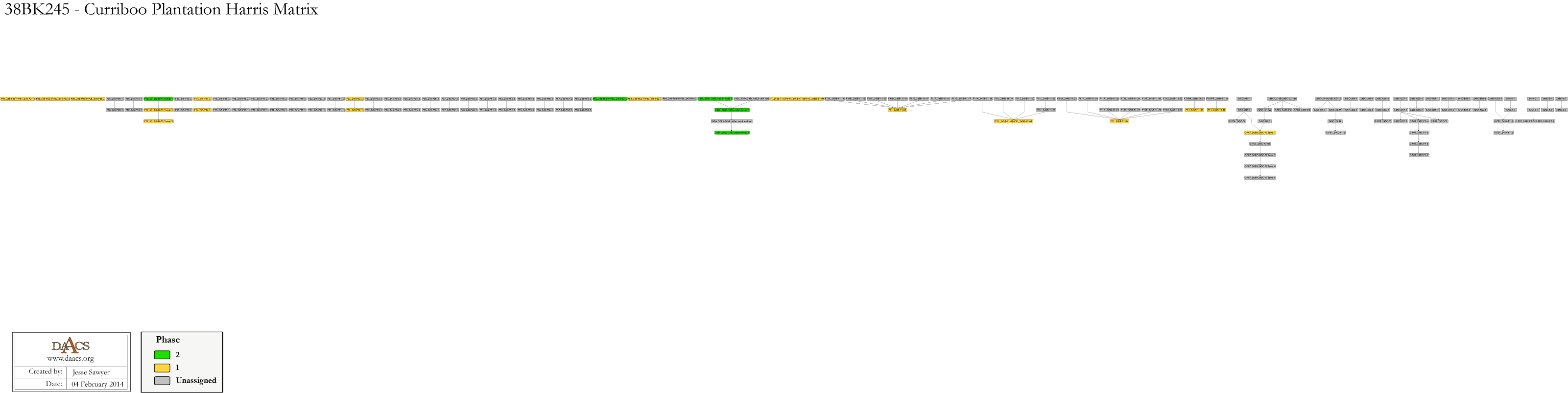
38BK245 Harris Matrix
The Harris Matrix summarizes stratigraphic relationships among excavated contexts and groups of contexts that DAACS staff has identified as part of the same stratigraphic group. Stratigraphic groups and contexts are represented as boxes. Lines that connect these boxes represent temporal relationships implied by the site’s stratification, as recorded by the site’s excavators (Harris 1979).
Stratigraphic groups, which represent multiple contexts, are identified on the diagram by their numeric designations (e.g. SG01) followed by the original excavator’s descriptions of them (e.g. “topsoil/root mat”). Contexts that could not be assigned to stratigraphic groups are identified by their individual context numbers (e.g. 245-F08-1).
Boxes with color fill represent contexts and stratigraphic groups with ceramic assemblages large enough to be included in the DAACS seriation of the site (see Chronology). Their seriation-based phase assignments are denoted by different colors to facilitate evaluation of the agreement between the stratigraphic and seriation chronologies. Grey boxes represent contexts that were not included in the seriation because of small ceramic samples.
See the Curriboo Chronology page for Stratigraphic and Phase information. Please note that some of the contexts present in the chronology analysis are not visualized on the Harris Matrix. The contexts that are not included do not have any stratigraphic relationships with other contexts. The lack of relationships can occur for a few reasons but two common examples are 1) the artifacts are from a surface collection, which is entered into DAACS as a context but does not have recorded relationships to other contexts that are below it ; 2) in cases where topsoil and plowzone are stripped and discarded, there may be features below the plowzone that are comprised of a single context. Since the plowzone does not exist as a documented context with artifacts, it cannot seal the single-context feature. DAACS also does not record subsoil as a context, so there is nothing for that single context feature to intrude or seal.
This Harris Matrix is based on data on stratigraphic relationships recorded among contexts in the DAACS database. It was drawn with the ArchEd application. See http://www.ads.tuwien.ac.at/arched/index.html.
For a printable version, download the Harris Matrix [2.72 MB PDF].
38BK245 – Curriboo Harris matrix


CAD plan in PDF format.
Anthony, Ronald
2003 Tangible Interaction: Evidence from Stobo Plantation, Another's country: Archaeological and Historical Perspectives on Cultural Interactions in the Southern Colonies in Historical Archaeology, Vol. 37, No. 4 Edited by J.W. Joseph and Martha Zierden.
Brockington, Paul , Jr.
Institute of Archaeology and Anthropology, University of South Carolina, Research Manuscript Series No. 169, 1980. Cooper River Rediversion Canal Archaeological Survey., Research Manuscript Series No. 169.
Ferguson, Leland
1989 Lowcountry Plantations, The Catawba Nation, and River Burnished Pottery, Studies in South Carolina Archaeology: Essays in Honor of Robert L. Stephenson in Anthropological Studies. Book 10. Goodyear, Albert C. and Hanson, Glen T.
Garrow, Patrick , and Thomas Wheaton
1985 Acculteration and the Archaeological Record in the Carolina Lowcountry., The Archaeology of Slavery and Plantation Life
Harris, Edward C.
1979 Principles of Archaeological Stratigraphy. Academic Press, London, England.
Wheaton, Thomas , Amy Friedlander , and Patrick Garrow
1983 Yaughan and Curriboo Plantations: Studies in Afro-American Archaeology. Soil Systems, Atlanta, Georgia.