Located on the leeward side of Nevis, the Jessups Estate was an established sugar plantation of 180 acres in the early 1720s. By the mid-1700s, Jessups had grown to over 250 acres with an enslaved population of over 110 individuals. A number of evocative primary documents, including a richly detailed 1755 plat and a 1740 slave inventory, provide important glimpses into the landscape and demographics of the plantation.
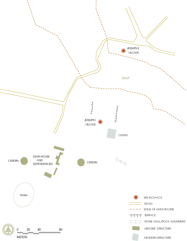
Archaeological research has confirmed the location of two slave villages, the first village, Jessups I, dates from the mid-1700s to the early 1780s. A subsequent village, Jessups II, was located to the north of the first village and was occupied from the early 1780s through emancipation in 1834.

Documentary Background

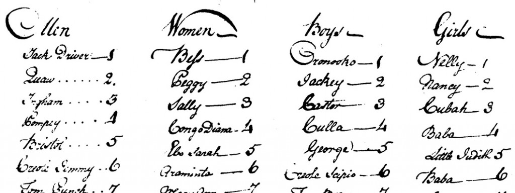
Excerpt from the 1740 slave list for Jessups Estate.
The documentary sources for Jessups plantation are principally title deeds and estate records. These have been found in the Court House on Nevis where inhabitants took documents of importance to be entered into the official books and in the Southampton Archives Office which acquired the records of a firm of solicitors who had acted on behalf of the inheritors of the Jessups estate.
History of the Plantation
The plantation first enters history in 1720 when it was held by Ann Abbot, who was most likely the widow of Thomas Abbot. In 1720, the estate was 180 acres in extent running from other plantations on the seaward side up into the mountain on the east. The Abbot family had been prominent in the government of Nevis in the early 18th century. Richard Abbot became Brigadier-General of the militia in 1711-12 and was in command in 1712 when the French captured the island. In 1708 the estate of Thomas Abbot had 33 slaves, 16 men and 17 women.
By 1734 the Abbot estate had passed to Phillip De Witt and Anne his wife. De Witt was probably Dutch, reminding us of the proximity of the Dutch island of St Eustatius to the north. By 1736, however, most of this estate was in the hands of Edward Jesup, a gentleman of St Christopher, who then purchased the estate from the De Witts with the exception of one small part on the seaward side known as Coles Point, which he purchased two years later. Our first view of the estate is a map surveyed in 1755 and commissioned by Jesup to show his landholdings on Nevis extending from the sea to the mountain, and showing in the center the estate’s great house and the adjacent slave village.
From the Southampton Archives we know something of Jesup’s management of his estate through his manager on Nevis, Benjamin Legett. The managers must have been responsible for drawing up the extremely detailed inventories of the buildings and stores, plantings, stocks and slaves belonging to the estate, dating from 1748, 1767 and 1773. The inventory of 1748 is a list first of the slaves, then of the cattle and other livestock. The details of the livestock show that parts of the plantation must have appeared like any English farm, 49 cattle, 29 sheep and 19 mules must have been scattered through various fields of the plantation.
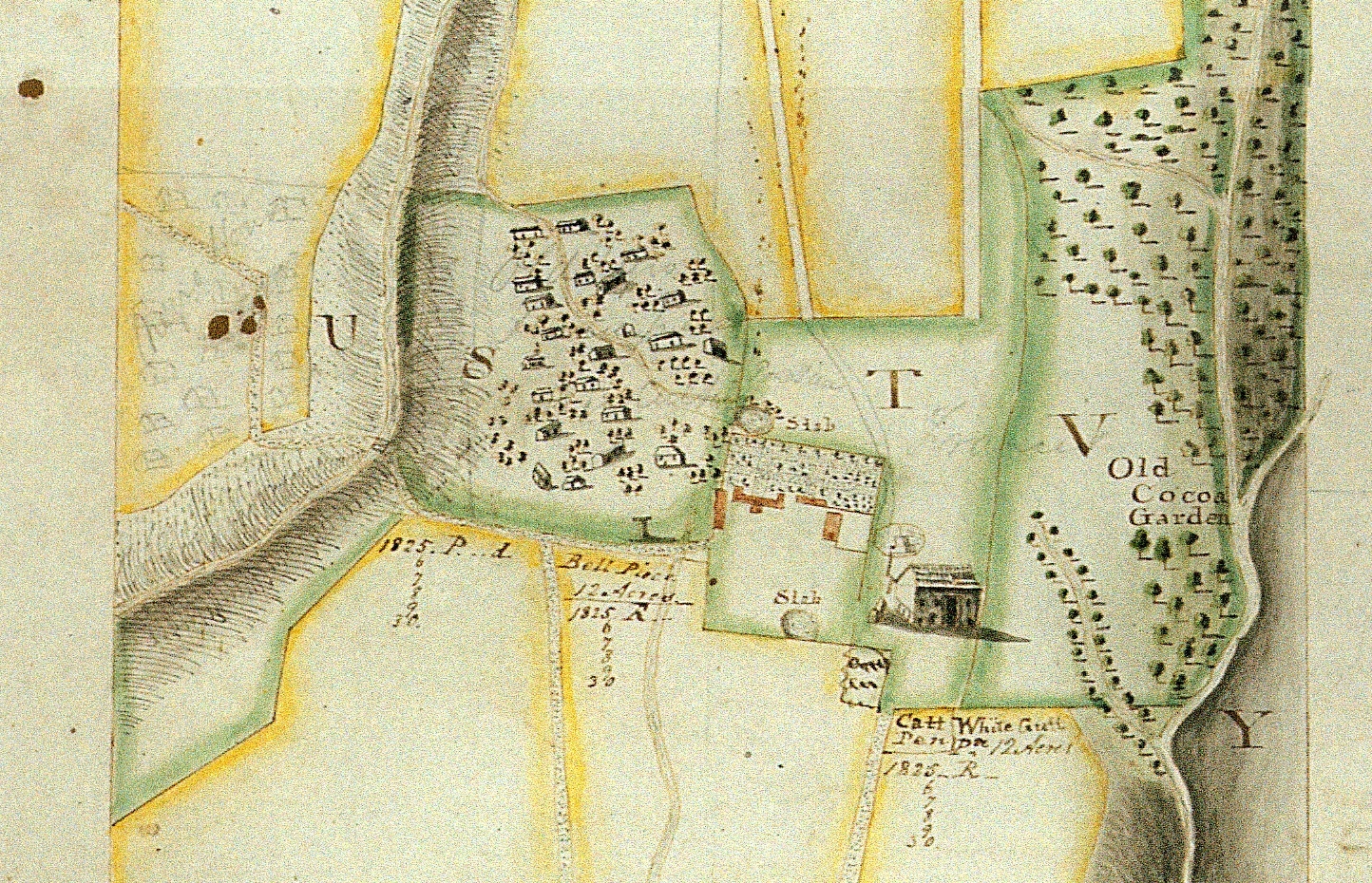
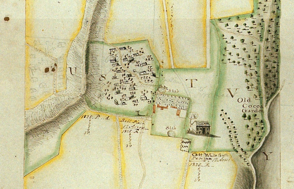
Excerpt from the 1755 plat of Jessups Estate. This excerpt show the main house and works complex on the right, the early slave village, Jessups I, in the center, and the 19th-century slave village, Jessups II, penciled in on the left.
The 1748 inventory also provides the names and general ages of each individual owned by Jesup. That year Jesup owned 53 men, 29 women, 18 boys, and 11 girls. Another two boys appear to have been in transit to the property, therefore the total slave population was listed as 113 individuals. Several names are embedded with clues to a person’s ethnicity, age, occupation or parentage. In these cases, two names are provided for a single individual, one proper name and one descriptor. For example, the first enslaved man listed is ‘Jack Driver’, suggesting his role as the driver within the village or gang. Two other men were listed with their possible occupations, ‘Mason Cockoe’ and ‘Cooper Cuffee’. Five men carried names that allude to their ethnicity, ‘Mundingo [sic] Prince’, ‘Creole Harry’, ‘Creole Sammy’, ‘Congo Jemmy’ and ‘Congo Scipio’. Four are listed as “old”: ‘Old Man’ ‘Old Jack’, ‘Old Jackoe’, and ‘Old Pompey’.
No women had occupations linked to their names but four carried names suggestive of their origins in Africa. These women included ‘Congo Diana’, ‘Ebo Sarah’, ‘Ebo Jenny’, and ‘Ebo Mary’. ‘Old Sarah’ and ‘Great Kate’ were listed last and were most likely the oldest enslaved women on the property. The 1748 list also provides clues to family groups. Priscilla, Ebo Sarah, Sabine and Judith each had a boy and Bess, Fanny, and Mary Ann each had one girl. Children’s names such as ‘Little Cuffee’, ‘Little Lucas’, and ‘Little Judith’ may also provide clues to parentage and family structure at Jessups Plantation.
The later history of the plantation embraces the leaving of the estate by Edward Jesup on his death to his brother-in-law John Ede. Descendants of Ede lived first at Bathwick House near Bath, and then in Southampton at Fernside, Bassett, Southampton. On their final sale of the estate in 1881 their solicitors were Green and Moberley of Southampton whose collections in the Southampton Record Office contain the various records relating to the Jessups plantation on Nevis.
The 1755 Map of Jessups Estate
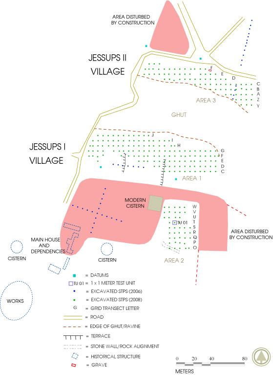
Site plan of Jessups I and II survey areas compiled by DAACS using 2006 and 2008 Total Station data and 1750 Jessups Plat. Shows areas disturbed by recent development.
Maps were a means by which estate owners living in England could show off and display their lands in the West Indies at some distance. The 1755 map contains a wonderful array of information about his estate.
Jessups plantation lies on sloping ground on the west side of the island of Nevis. The map shows the estate in two parts: on the left is the upper part of the estate, running up to the forest below the mountain peak; on the right is the lower part of the estate extending down to the sea. The two parts of the estate together stretched from the mountain on the east to the sea on the west. In the part on the left hand side were situated the centre of the Mountain Plantation, the great house, the sugar works, the slave village (i.e. to the east), and slave provision grounds. Little survives of the plantation house or works.
Close to this house were two slabs or waterholes and the ‘old cocoa garden’. Uphill were various fields given over to sugar cultivation, while further uphill were pasture fields, a provision ground, and forest. The provision ground was land set aside for slaves to grow their own food high up the hill side and was characterised by stone banks forming individual allotments; it is still in use today. Downhill of the great house and works were further sugar cane fields and also a second plantation centre, the Lower Plantation, shown on the map as a group of buildings with a cattle mill. This was possibly the Coles Point plantation purchased by Jesup in 1738. Combining archaeological survey with historical research has revealed a number of instances of smaller plantations being absorbed into larger ones, but in this instance the earlier buildings of the smaller plantation still remain to be located.
Perhaps the most striking feature of the plat is the detailed representation of the “Negro Houses”, an early slave village [Jessups I] northeast of the great house and works, where twenty-two structures of various sizes are arranged across the landscape. A path winds approximately north/south through the village and a number of the houses appear to front the path. The northern edge of the village is bounded by a steep ghut, through which an intermittent stream flows after rainfall. Sometime after the completion of the 1755 plat, the plat was edited to show the location of a second village. Located north of the gut, the lightly penciled later village shows at least 13 structures [Jessups II], confirming SKNDAI’s archaeological assessment that at some point during the third quarter of the 18th-century the early village was moved north of the ghut. The depiction of the slave village on this map is the most detailed known from Nevis.
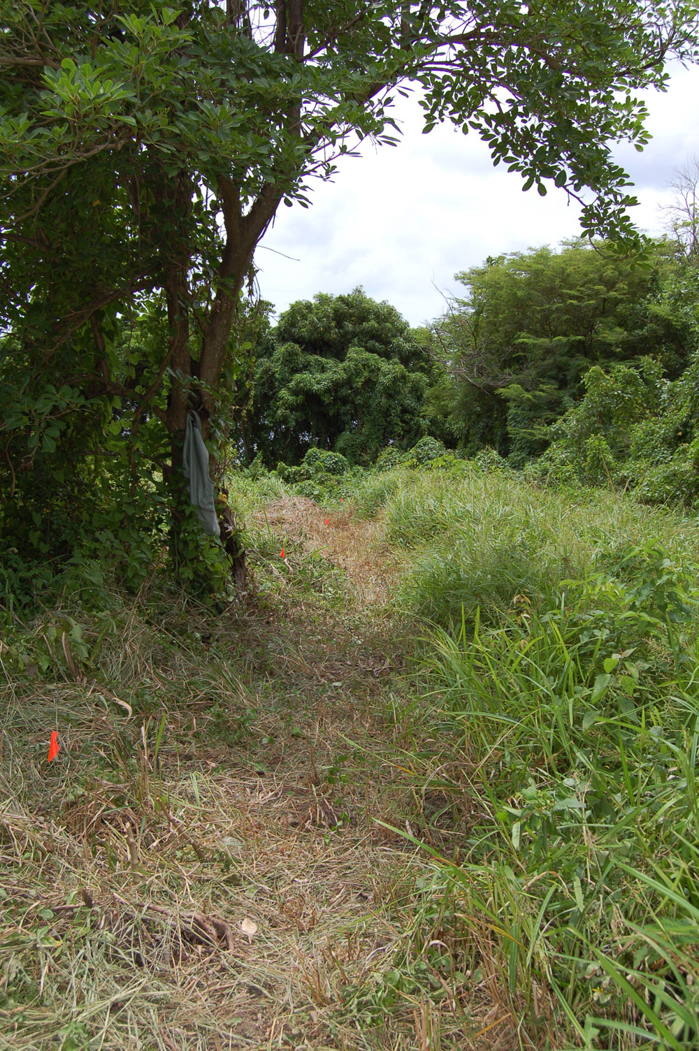
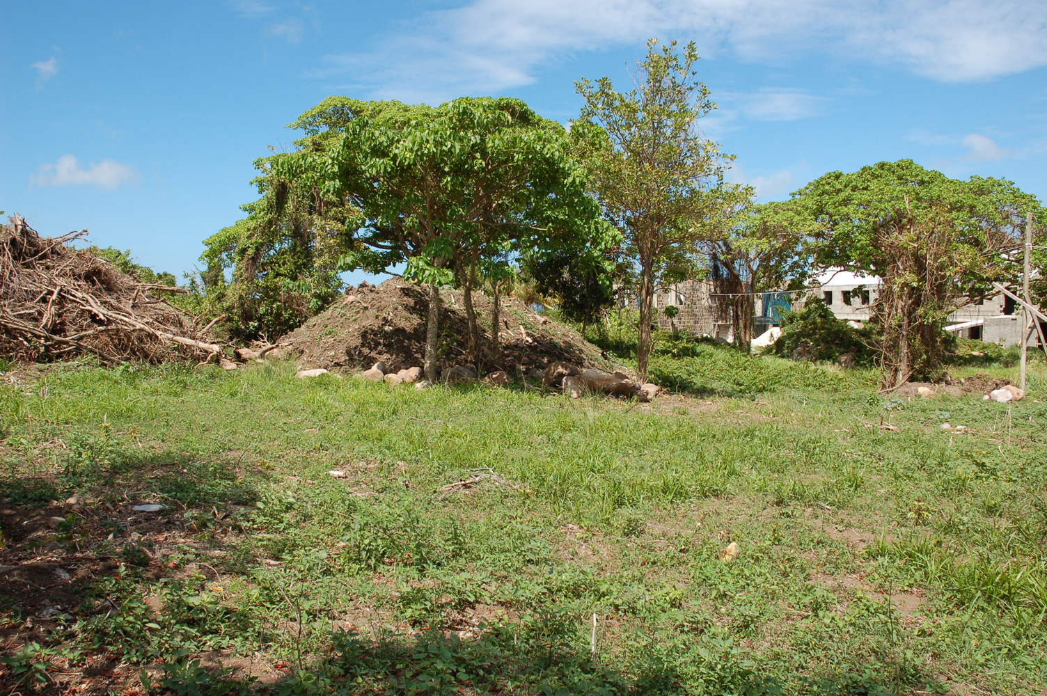
Much of the two village sites is covered with dense forest, which has grown up since the sites were abandoned, although interestingly a modern path through the trees still follows the route of the path shown on the 1755 map. There had been two threats to the site in recent years. Firstly, in the early 2000s it was thought that development for new houses was destroying earlier slave graves, one of which was well known. The second threat materialised in 2008 with further housing development. The project archaeologists realised that this had begun to destroy the site of the earlier slave village, so work was needed urgently to record any remains before they were lost forever.
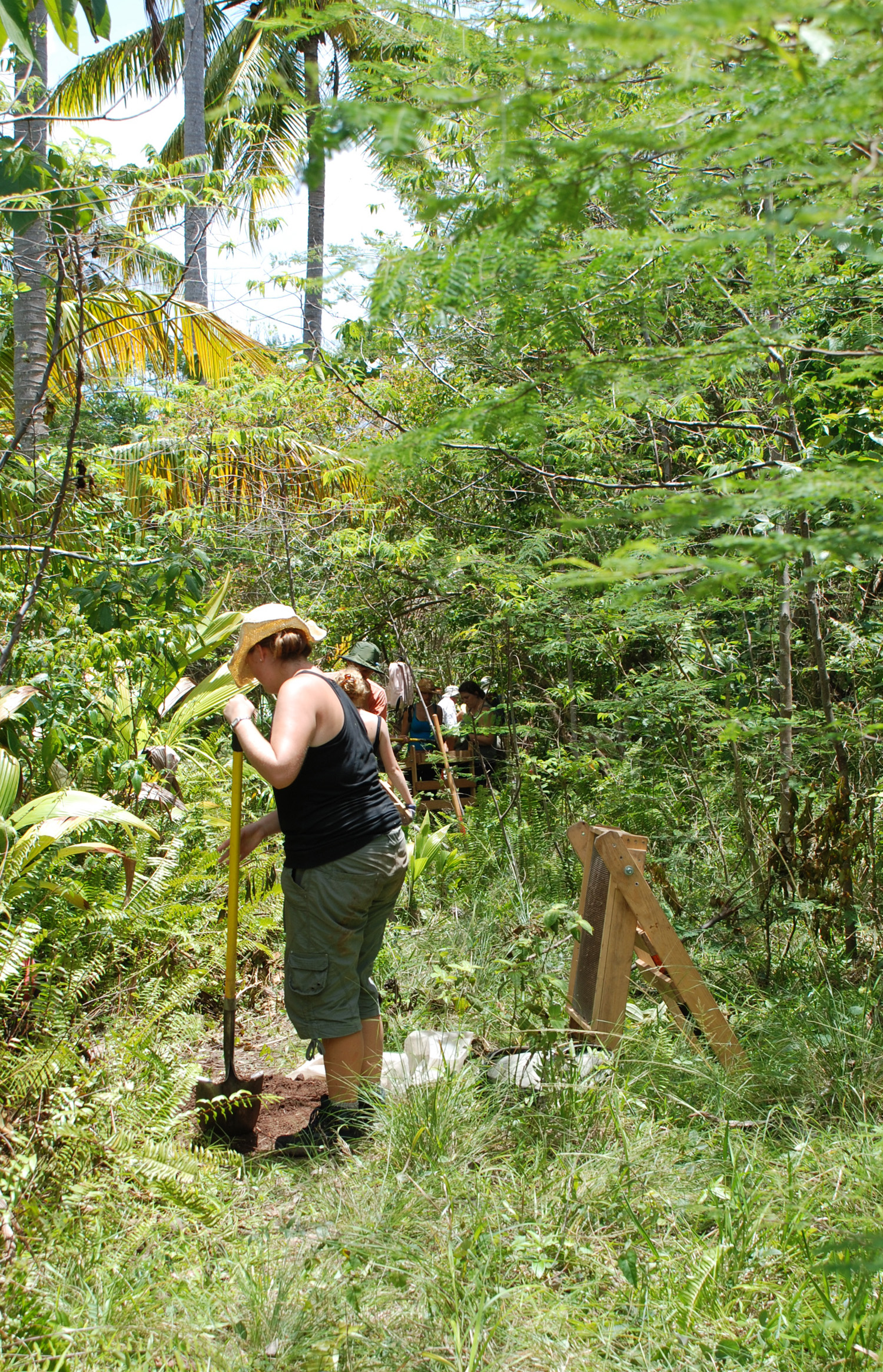
University of Southampton students excavating shovel test pits along a transect at Jessups II.
Archaeological Research at Jessups Estate
In July 2006, DAACS undertook a two-week survey of slave villages on Nevis in collaboration with archaeologists from DePaul University, the University of Southampton, and National Museums, Liverpool. Goals included locating and initiating preliminary shovel-test-pit surveys of three slave-village sites: Jessups I, Jessups II, and Upper Rawlins. Twenty-seven shovel-test pits were excavated at Jessups I and 16 STPs were dug at Jessups II. This was the first archaeological research to be conducted at the Jessups estate.
Archaeologists affiliated with the St. Kitts-Nevis Digital Archaeology Initiative returned to the Jessups’ village sites in 2008 to complete the surveys begun in 2006. A total of 204 shovel test pits and one 1-x-1 meter unit were excavated at Jessups I. All data recovered from archaeological research at the Jessups villages can be searched and downloaded through the queries available on the DAACS Query Page. Detailed background and chronological information, as well as site maps and images, can be found on the individual site pages for Jessups I and Jessups II.
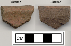
Locally-made coarse earthenware, often referred to as Afro-Caribbean Ware, excavated from a STP at Jessups II.
These surveys are part of a larger collaborative fieldwork project in the Caribbean known as The St. Kitts-Nevis Digital Archaeology Initiative (SKNDAI). The Jessups villages were selected for a number of reasons. First, a number of evocative primary sources provide glimpses into the development of the Jessups Plantation. These documents include an exceptionally detailed 1755 plat of the property that shows the location of these villages and their movement on the landscape through time, as well as a 1748 slave inventory. Please see DAACS document queries for access to images and transcriptions of these documents.
Second, the Jessups village sites are currently under development. Mountainside villas were built along the western edge of the Jessups II village in the early 2000s. Nearly one-third of the Jessups I village was been bulldozed in early 2008 to make way for more construction. As a result, portions of each village site were destroyed prior to archaeological investigation.
The St. Kitts-Nevis Digital Archaeology Initiative is funded by a JISC-NEH Transatlantic Digitization Grant to The Digital Archaeological Archive of Comparative Slavery (DAACS), Monticello, The University of Southampton, and the International Slavery Museum, Liverpool. The Jessups villages are a key component of a multiple-year research program in the Caribbean spearheaded by DAACS, known as the DAACS Caribbean Initiative (DCI).
Jillian Galle and Roger Leech
The Digital Archaeological Archive of Comparative Slavery and The University of Southampton
May 2011

