

Overview
Morne Patate is a plantation located in the enclave of Soufriere, Dominica, and can be understood as representative example of a plantation for the region in both size and agricultural strategy. Initially called Upper Soufriere Estate, the population consisted of both free and enslaved laborers, with a population that hovered around 120 people throughout its history as a plantation. Prior to the establishment of the plantation, the earliest habitation of the region has been dated between AD 771-903 AD by Kalinago residents. European occupation of Morne Patate in the years leading up to and immediately following 1763 are not well recorded in the documentary record, although it was part of the Soufriere Quarter and was likely established in the 1740’s by Nicholas Croquet Belligny. There are no records of how many enslaved people labored for Belligny during this period, but by 1763 Belligny had 117 enslaved laborers working on two adjacent estates that grew coffee, cacao, manioc, yams, and plantains (Hauser 2020:13).
Britain formally annexed Dominica in 1763, following the Seven Years War. Morne Patate grew rapidly in the wake of this political shift, as well as changing from a provisioning estate to a sugar and coffee plantation. According to probate records from 1777 and 1816 two estate houses were built, with one being a replacement for the other. By 1816 either Belligny or one of his successors commissioned a boiling house for sugar processing, indicating that the enslaved laborers working on the estate were producing sugar in addition to coffee. This is confirmed by documentation from 1827, which notes that the estate produced 21,000 pounds of sugar and 25,075 pounds of coffee Hauser 2020:14). By this point, the number of enslaved laborers on the estate fluctuated between 99 and 166. In 1833, however, British Parliament issued the Abolition Act, ending slavery in the British Empire and signaled another shift in plantation structure. People continued to work at Morne Patate following this change. There was a decline in coffee production beginning in the 1830’s due to a coffee blight, although it was still grown on the island, and by 1843 Dominica’s economy had diversified. This included growing arrowroot, producing firewood, and charcoal, which were likely sold to other islands. Additionally, lime trees were grown at the suggestion of British agronomists (Hauser 2020:14).
The archaeology of Morne Patate has focused on the lives of plantation laborers, before and after emancipation. The estate was structured to grow sugar, coffee, and provisions during its history. Consequently, inhabitants structured their lives around the demands of cash crops. Research has focused, therefore, on the everyday lives on plantation inhabitants, and the ways they changed sue to political and environmental shifts.
Archaeological Research at Morne Patate
Research at Morne Patate has taken place over the past ten years as part of the Archaeological Survey of Colonial Dominica. This project was designed to document plantation settlements as a means of collecting baseline data in order to better understand the development of plantation society. Ultimately, the survey documented eight plantation sites in the Soufriere region, included Morne Patate. Morne Patate was significant in understanding the development of the plantation system in Dominica for three primary reasons. The first is its long-term history, the second is the size and types of settlements inhabited, and, finally, the intact nature of the archaeological record. In addition to the archaeological merits of Morne Patate, community members were essential participants for the success of the project, and provided both intellectual and logistical support in collecting and interpreting data.
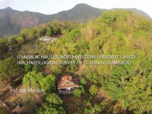
Aerial view of Locus 1 and Locus 2, Morne Patate Estate, Dominica.
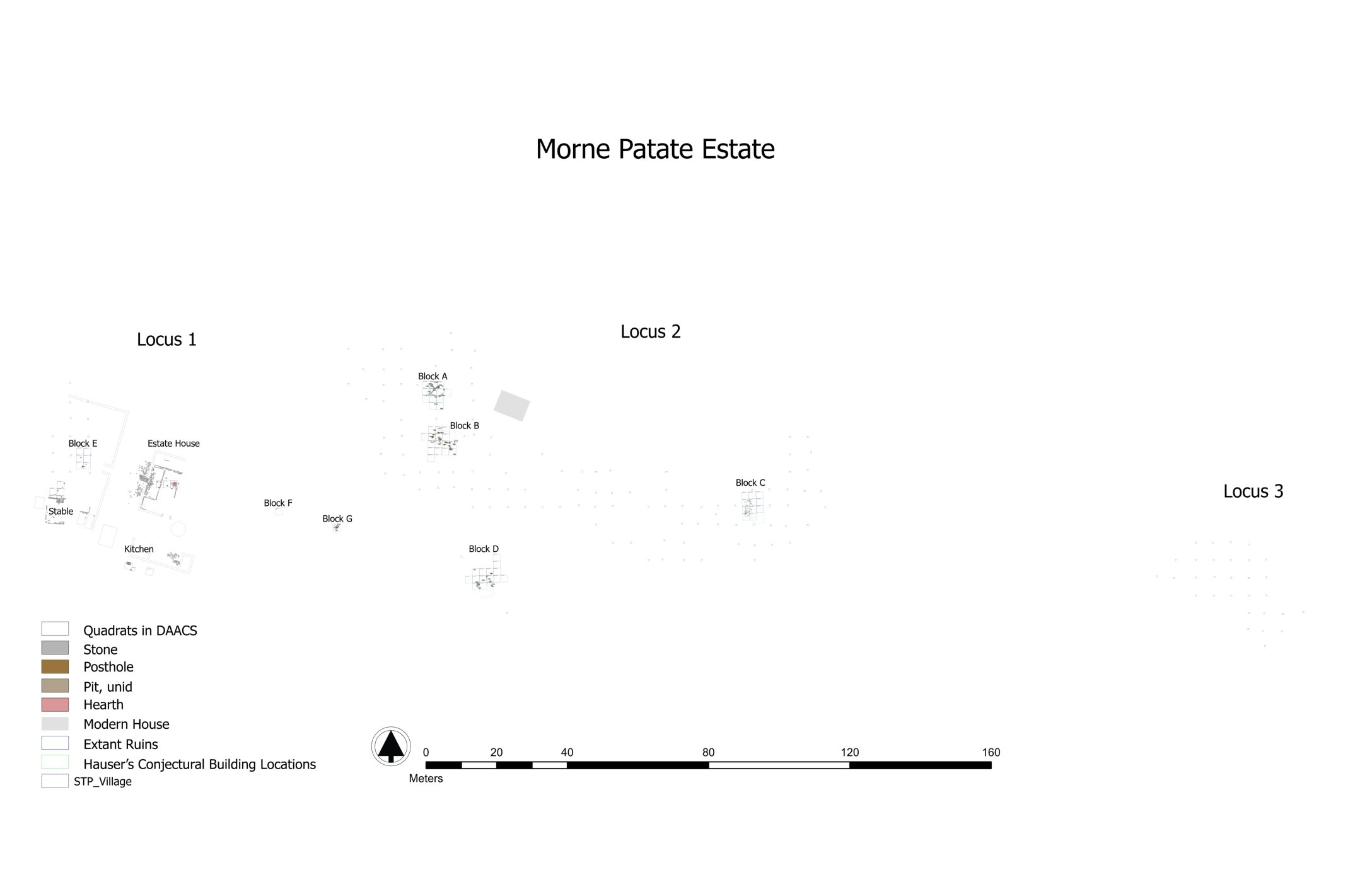
Excavations focused on domestic spaces at the estate house (Locus 1) as well as in the village (Locus 2), agriculture, and provision grounds (Locus 3). Archaeological research took place in multiple stages, beginning with walking surveys in order to understand how various parts of the estate were utilized in the past. In some cases, these areas are still utilized by modern residents for activities including gardens and making charcoal. Ultimately, 15 loci were identified, and 3 were excavated. The house yard was one of the primary means of interpreting the development of plantations and everyday life. Eight blocks were excavated in the house yard, and these blocks displayed various levels and phases of human habitation. Architectural features were identified through postholes, stones, foundations, and floors, which allowed archaeologists to discern how space was organized within the house yard. Following excavations, archaeologists utilized various comparative techniques to better situate the material culture, faunal remains, and macro botanical samples within the broader historical processes and everyday plantation life.
Phase 1
Phase 1 has an MCD of 1768. This, significantly, predates the introduction of sugar. Prior to European settlement, the region was inhabited by the Kalinago people. In the 1740’s the land was owned by Nicholas Croquet Belligny, who utilized the property to grown coffee and provisions. It is unknown how many enslaved laborers Belligny exploited during this period. On the Estate House and Dependencies (Locus 1), Maison 1, the Farina House, and House Area E date to this period. In the Village (Locus 2), House areas A, D, F, and G date to Phase 1.
Phase 2 and Phase 3
Phase 2 was found to have an MCD of 1797 and Phase 3 an MCD of 1818. This time period can be classified as the period of the sugar revolution. By the 1780’s sugar was being grown in addition to coffee and provisions. Numbers of enslaved living on the plantation fluctuated between 100’s and 160’s. In 1807, the slave trade was abolished, although slavery was not ended until 1833. From the Estate House and Dependencies (Locus 1), Maison 2, Farina House, the Stables, Factory, and the Boucan/ Glacee are from this phase. In the Village (Locus 2) House Area A, House Area B, House Area C, House Area D, House Area F, a Road, and House Area G date to this period. Finally, the Provision Ground and Garden (Loci 3) were established during this time frame.
Phase 4
Phase 3 has an MCD of 1843 and indicates the post-emancipation period. Following emancipation in 1833, workers on Morne Patate continued to grow sugar but ceased to grow coffee. This was largely due to a coffee blight that occurred around 1840. Although slavery was abolished, Morne Patate continued to function as plantation, and multiple features have been identified from this time period. These include the Maison 3, Factory, Stables, and Boucan/ Glacee at the Estate House and Dependencies (Locus 1). House Areas A, B, and C, as well as a Road date to this phase from the Village (Locus 2). The Provision Ground and Garden (Loci 3) was also still active during this phase.
Phase 5
The final documented phase is comprised of activity has an MCD of 1866. Morne Patate remained a functioning until the 1970’s, although the permanent population decreased sharply in the 1880’s. Workers began producing limes between the 1930’s and 1970’s. Maison 3, the Factory, Caretaker’s House, and Boucan/ Glacee were all in use through the 1950’s at the Estate House and Dependencies (Locus 1). Additionally, the House Areas A, B, and C were sites of activity until c. 1900 at the Village (Locus 2), and the Povision Ground/ Garden (Locus 3) was also in use until 1900.
Emily Schwalbe and Mark Hauser
Northwestern University
January 2021
