| Location: | Dominica |
|---|---|
| Occupation Dates: | Late 18th through mid-19th century |
| Excavator(s): | Mark Hauser, Northwestern University |
| Dates excavated: | 2011 |
Overview

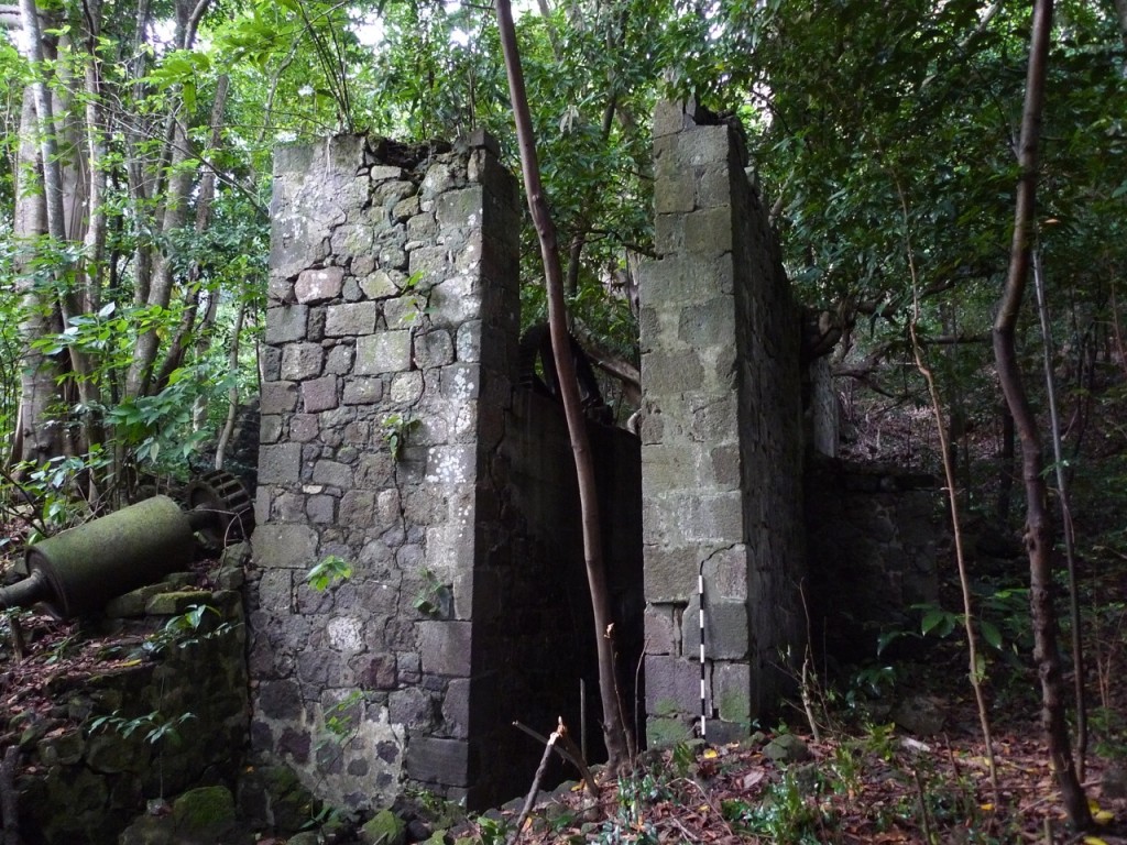
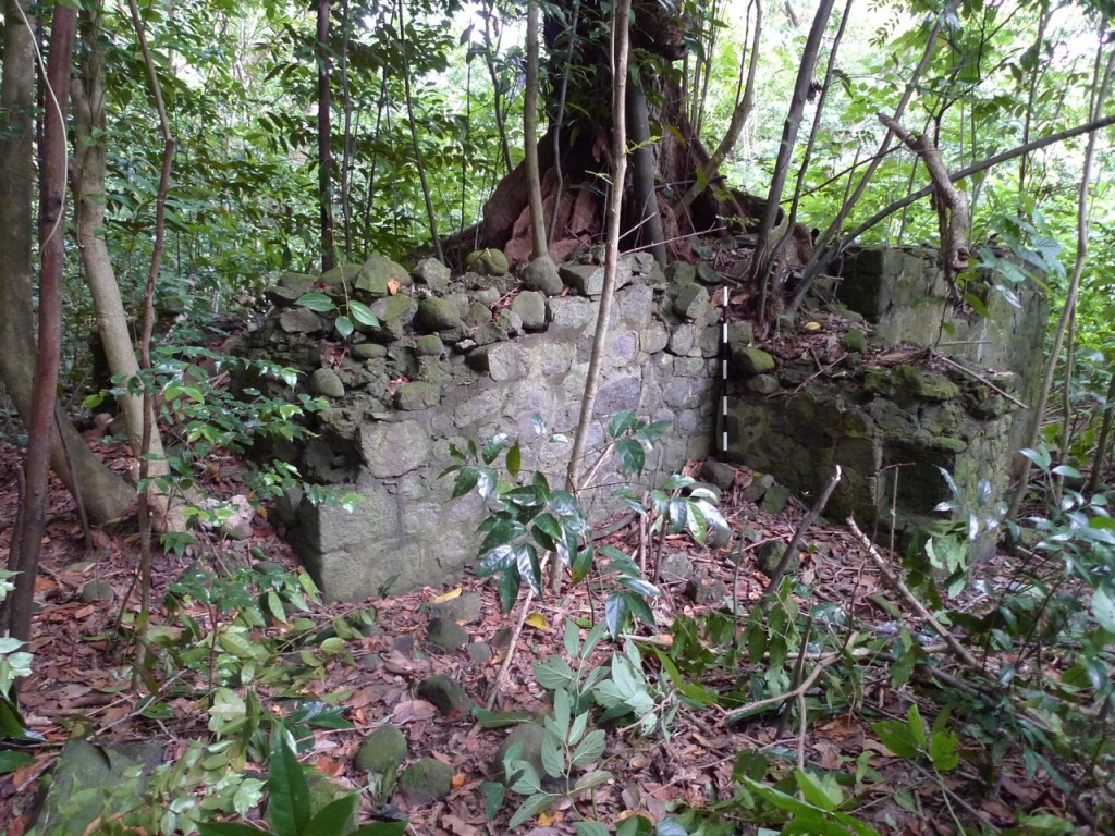
Water Mill. Refitted sometime after the 1830’s. Sugarloaf estate continued to produce sugar well after the village was abandoned in 1834.
Archaeologists affiliated with Northwestern University conducted research at the site of the Sugarloaf Estate in May 2011. One hundred and thirty-eight shovel test pits (STPs) and fifteen 1-x-1 meter test units were excavated at Sugarloaf between May and July. In addition, a total station and GPS unit were used to digitally map the landscape and extant structures related to the estate, which was established in the 1770’s and was occupied through emancipation until 1834. Instrumental Neutron Activation Analysis (INAA) and petrography were conducted on the small sample of local coarse earthenware from this village. Preliminary analysis on the archaeological data from the Sugarloaf village suggests that enslaved people lived on the estate from 1770’s until the 1830’s. The village was abandoned shortly after a destruction event in the 1830’s.
The survey was part of an international collaborative fieldwork project in the Caribbean known as the Archaeological Survey of Colonial Dominica (ASCD). The survey was funded through a Post-PhD grant from the Wenner Gren Foundation of Anthropological Research and a High Risk grant from the National Science Foundation, Archaeology Division. Collaborators included Dominica Island Heritage Foundation, Kutztown University, University of South Carolina, and University of Massachusetts, Boston. The award was made to Northwestern University.
The Sugarloaf Estate village is also a key component in a larger attempt to compare estates established in the years immediately preceding and following annexation of the Island by the British empire in 1763. The ASCD’s immediate goal was to document archaeologically, through survey, excavation and collections analysis, the changes in landscape, housing and economic networks of slaves in Dominica in the last quarter of the eighteenth century and the first quarter of the nineteenth century. The ASCD’s ultimate goal was to establish elements for substantive comparison of similarities and differences in imperial prescription and everyday practice in colonies.
Documentary evidence
Water Mill. Refitted sometime after the 1830’s. Sugarloaf estate continued to produce sugar well after the village was abandoned in 1834.
Eponymously named for a hillock on the grounds of the property, Sugarloaf Estate has functioned since 1763. It is located on the leeward side of Dominica, just outside the town of Portsmouth. Today the former sugar fields are either unused or serve as a pasture for horses. During the particular conjuncture under scrutiny for the chapter, Sugarloaf Estate was most closely associated with the ownership of Richard Neave. Neave was a powerful London merchant whose social and professional networks brought him in constant interaction with absentee planters who held properties in St Kitts, Nevis, and Antigua (Johnston 1965: 199). In 1768 Neave purchased the estate from Irishmen, John Blackall and Nicholas Comyn. The tenure of ownership was short lived and by 1768, Richard Neave, petitioned to purchase the property including 78 acres of cleared land. In 1768, Neave instructed his attorney, Thomas Rainey, to purchase an additional 230 additional acres of contiguous lands and acquire the means to turn this property into a functioning sugar estate. According to an indenture dated September 23, 1823, James Neave, Richard Neave’s son sold Sugarloaf to a Dominican attorney, John Laidlaw (Grants, Conveyances, Leases, Mortgages; Dominica National Archives 9 23 1843).
There is little information about the works or mansion at Sugarloaf. The indenture between Neave and Blackall and Comyn records the presence of 15 negro huts on the property. Over sixty years later we have some sense of the improvements completed in Neave’s name. In 1843 an earthquake struck Dominica. A report filed enumerating damages to major estates in the region details some of the structures present. These included a Boiling House, a distillery, sugar works, black smith shop and a stable. The estimated damage was 1050 pounds sterling (House of Commons Papers 1843, Volume 33 page 4).
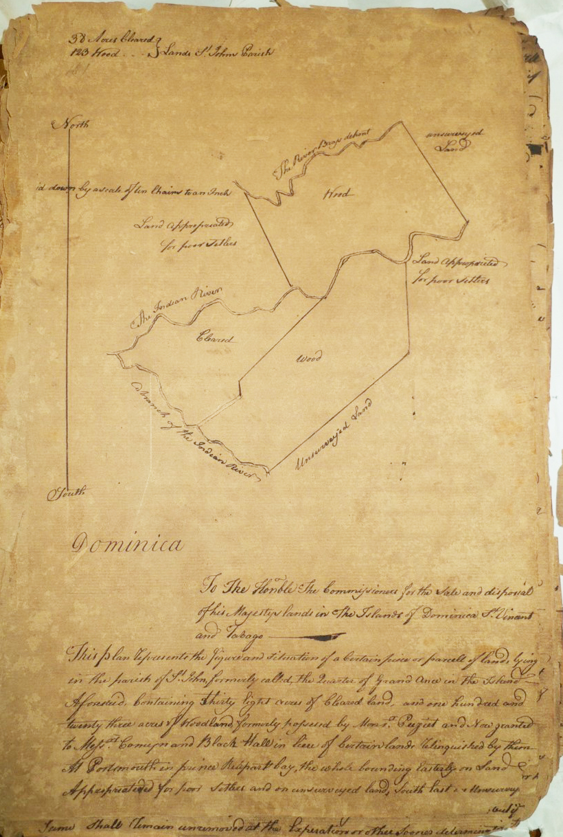
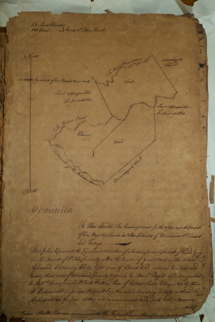
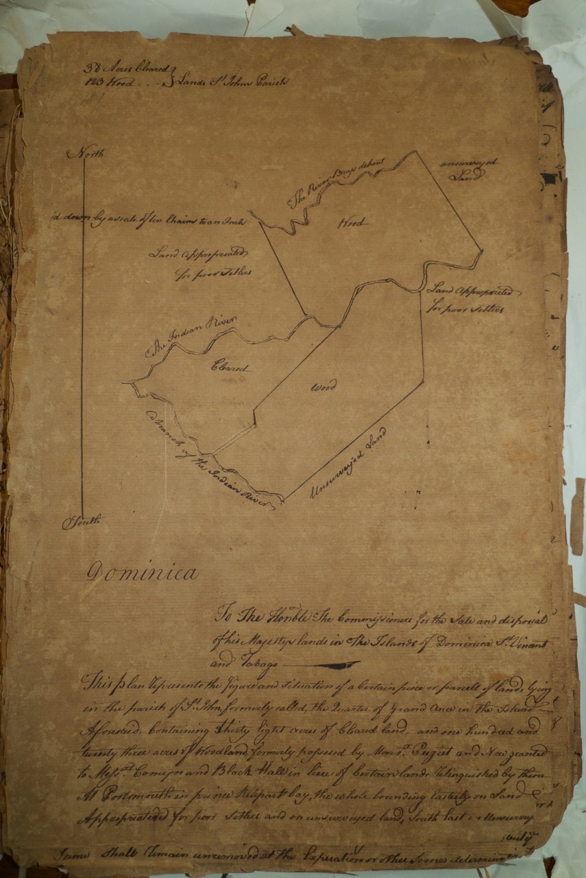
Indenture plat for Sugarloaf, 1765.
The slave population at Sugarloaf varied over time. If we estimate that each house contained between five and six laborers per house, the village in the 1768 indenture would have housed 60 to 75 laborers. By 1799 the number of slaves living on the estate was 209. In the previous three years there were 62 births and 51 deaths. Neave had also purchased 49 slaves in that time period. There is little documentary evidence in the manner of accounts produce. According to the 1817 Triennial Slave Register, 137 enslaved laborers processed cane from 134 acres. The vast majority of enslaved laborers were born outside of Dominica (85%), and half of the enslaved African population was born in Africa after 1795. All creole (born outside of Africa) enslaved laborers were born either on St John, Nevis or Montserrat between 1740 and 1780. The 1817 slave register does not list any Dominican-born slaves over six years old. According to an unnamed member of the Dominican Legislature in 1823 Wesleyan Missionaries baptized five of the slaves. In September of 1834—two weeks after the passage of the Act of Emancipation—a hurricane hit the island of Dominica and killed three people on Sugarloaf Estate (Anonymous 1835: 313; Accounts and Papers of the House of Commons; No 56- Letter from J. S. Brickwood to the Lord Commissioners 1855). The village was abandoned and never to be reoccupied.
Excavation history, procedure and methods
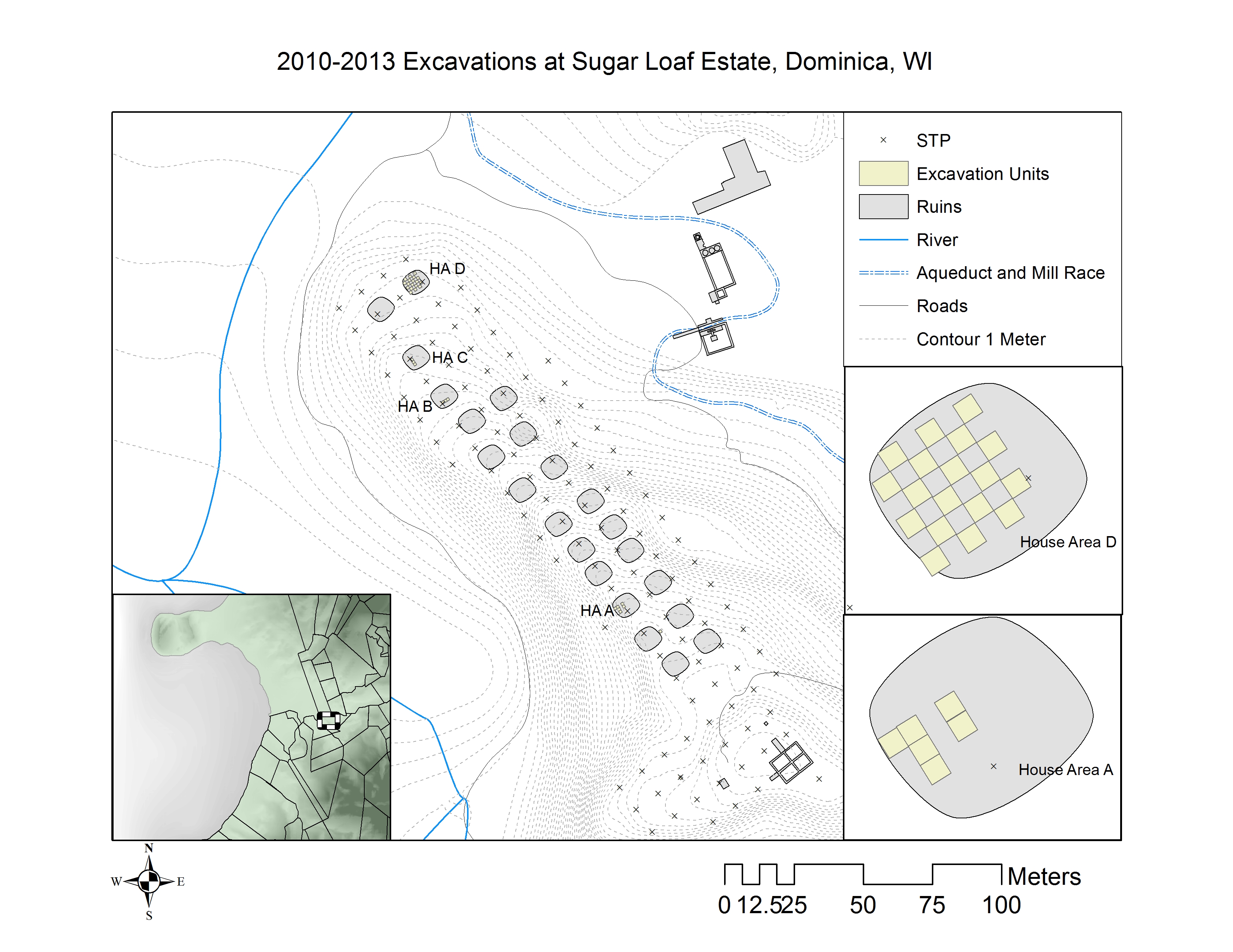
Sugarloaf site map prepared by Mark Hauser. Materials from the 2011 season are available through daacs.org.
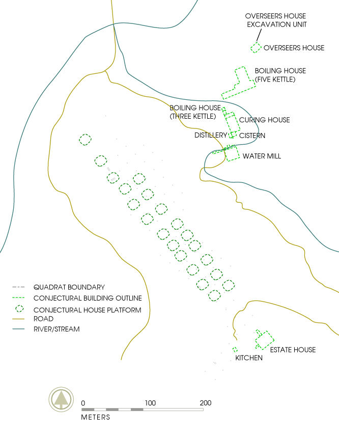
Sugarloaf is located in the Caribbean side of Dominica on either side of the Indian River. There are no plats or maps indicating the location of the village. The property is currently owned by Celma Dupigny and her son. The property is largely overgrown and the ruins of the sugar works and the estate house are not visible from the major road. Lennox Honychurch identified the location of both the Watermill in the floodplain of the river and the Estate house on the crest of the hill.
In May 2010, Mark Hauser, Michael “Togo” Sanford and students from Northwestern University conducted a pedestrian survey to locate archaeological deposits associated with Sugarloaf estate. Members of the team employed compasses, as well as hand-held gps units while walking 500-meter transects at 20-meter intervals. Pedestrian survey identified two boiling houses, the estate house, a watermill, an aqueduct, a dependency with a stone foundation, field walls, and a small-gauge railroad.

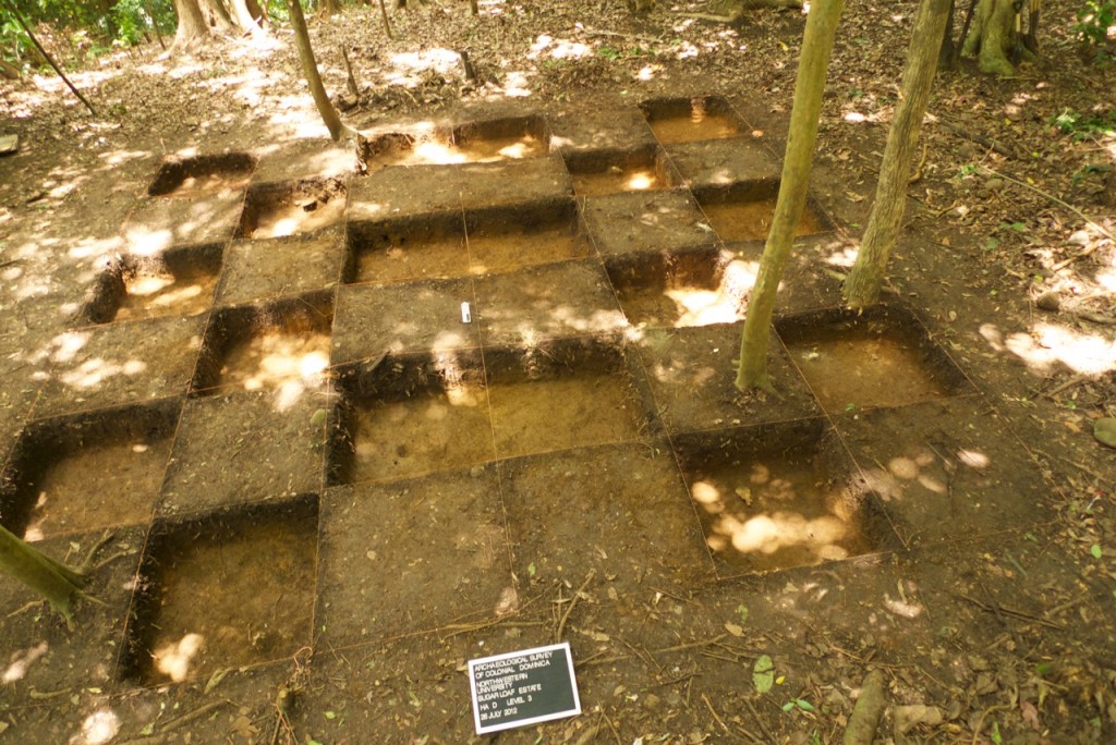
House Area A: a posthole and hardened surface.
Pedestrian survey located the slave village, which was composed of 22 artificially dug terraces north-west of the estate house that descend in a roughly parallel fashion downhill. These were the spaces upon which the slave quarters were constructed. The alignment was planned such that 11 terraces were dug on either side of a central path that may have articulated movement between the terraces. Each terrace was approximately 12-x-8 meters and a relatively uniform 2.5 meters above or below the next terraces to the front or rear. These terraced house areas were separated from the estate house by a stone wall and an unpaved road leading to a stable in the vicinity of the estate house. Surface scatter included cast iron objects, a combination of creamwares, pearlwares, and whitewares as well as fragmentary free-blown, and dip-molded glass bottles. The pedestrian survey informed the general locus of more intensive testing.
With funding from NSF and the Wenner Gren Foundation, archaeologists with ASCD returned to Sugarloaf in June 2011 to begin STP survey. Mark Hauser, James Delle, Dominican field technicians, Michael Samford and Edward Thomas, and students from Northwestern University and Kutztown University excavated 138 STPs and 12 1-x-1 meter units between June 10th and July 15th.
Based on the pedestrian survey in the project employed a shovel test pit strategy. The team excavated 40-x-40 centimete square holes placed at 10-meter intervals across the village. This allowed for an average of two holes per terrace. The survey provided both the general shape of the slave village and a superficial understanding of landscape features identified in the walk over survey. Sterile soil was reached between 10 to 30 centimeters of depth. STPs with no artifacts were documented but not assigned a Field Specimen Number (a context control identifier).
Shovel Test Pit strategy allowed the team to make a number of inferences about land use. Artifact densities varied between terraces. A little less than half of the terraces contained five artifacts or less per 10 square meters, and more than half produced greater than 30 artifacts per 10 meters squared. These densities alternated with each terrace suggesting a patterned difference in land use. The small density of architectural and household related artifacts would be consistent with garden areas attached to houses. Woodville Marshall has described general land use patterns in the eastern Caribbean with special attention to the four areas that were used by laborers to grow their own food. Yam grounds were small plots (12-x-12 meters) of land placed in areas under preparation for sugar cultivation (Marshall 1995: 50). Gardens were located adjacent to laborer houses and in Grenada were mandated to be 1/40th of an acre (Marshall 1995: 51). Dependent lands, like provision grounds and cocoa walks, were placed in upland and forested portions of the estate. It is probable that the areas with low artifact densities were such gardens.
The kitchenware assemblage (utilitarian coarse earthenwares and iron kitchenwares) from the survey was particularly remarkable. Fragments recovered include a French earthen pottery called Vallauris, a local coarse earthenware called coco neg, and cast iron vessels. Their relative proportions, however, are quite uneven. Only six fragments of Vallauris were recovered and one coco neg, together making up less than 15% of the total kitchenware assemblage. Cast iron vessels, in contrast, made up over 85% of the assemblage with 40 fragments.
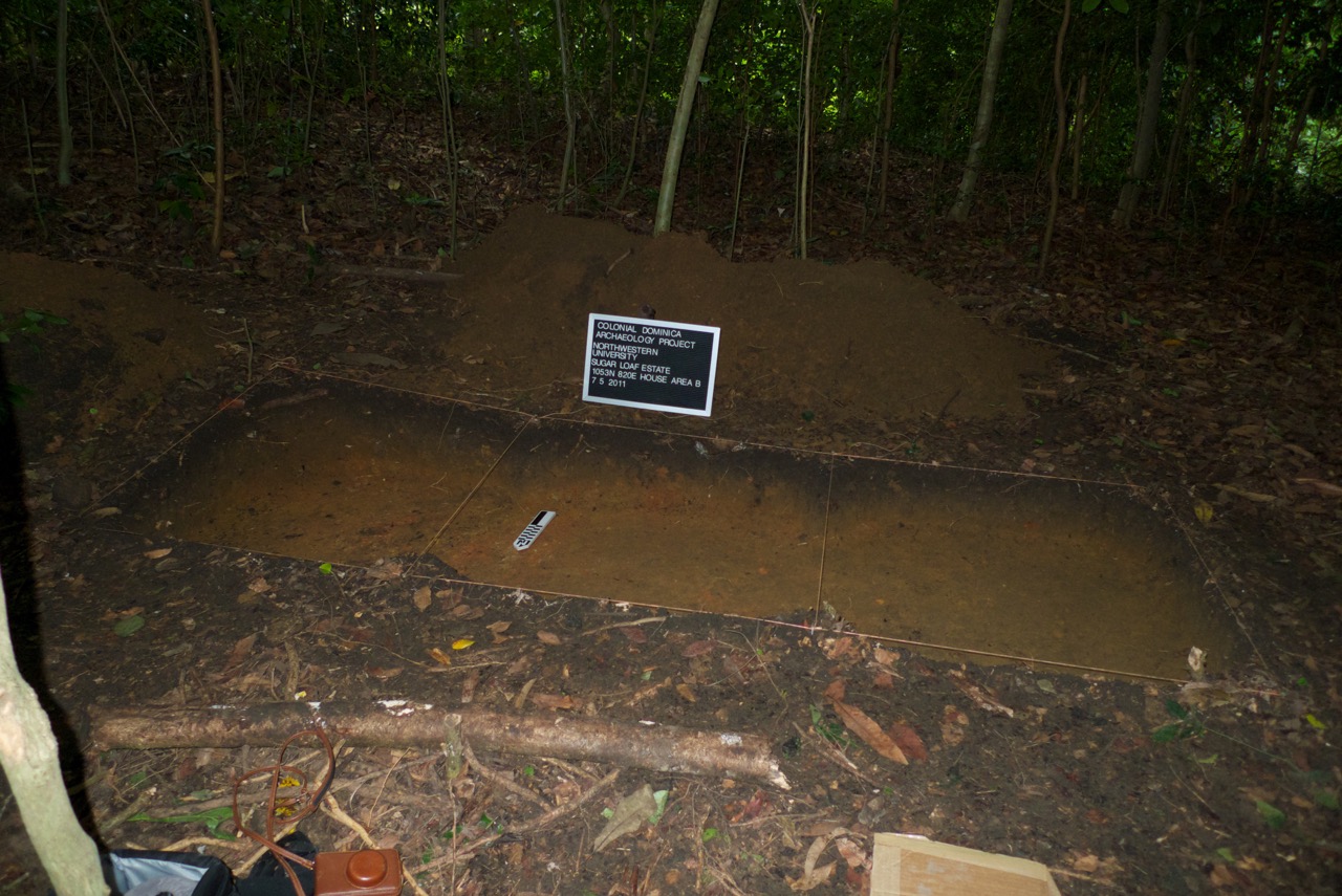
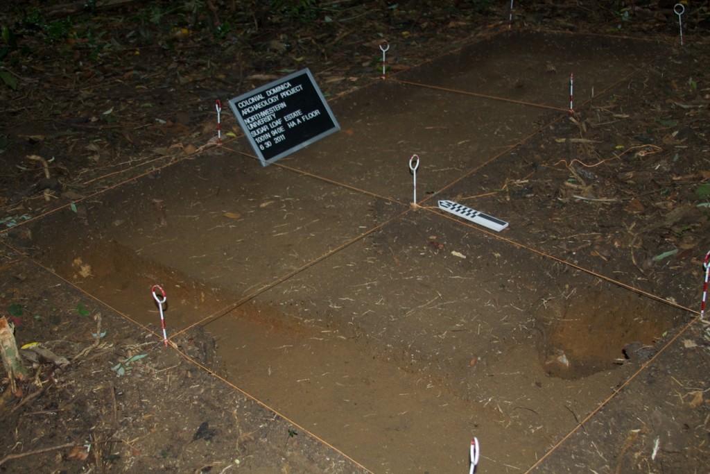
House Area B: Note that the floor of the house area is level after excavating the first two layers.
Further testing was conducted on a small sample of house areas. Artifacts recovered from this phase of the project are not represented in the DRC database. Dr. Hauser returned to Dominica in July 2012, with a team from University of South Carolina, University of California Los Angeles, and University of Massachusetts Boston to conduct a shallow geophysical survey on the village. The team included, Douglas Bolender, Jonathan Steinberg, Brian Damiatta, Cat Katlin, Kenneth G. Kelly and Mark Hauser. They were assisted by Dominican field assistants, Michael Samford, Edward Thomas, Dean and Dorival Bellot. Archaeogeophysics conducted in March 2012 was useful in establishing variation within village locations and detecting potential anomalies. As such it proved an indispensible guide for excavation strategies in Phase 2. For each village the team used a combination of soil conductivity techniques (Em 31 and EM38), GPR and fluxgate magnetometery to survey approximately 1/3 of the village (n=4 platforms).
At Sugar Loaf Estate a 34.5-x-40 meter grid (Grid 1) was setup along a lower slope of the hill leading up to the ruins of the Maison at Sugar Loaf. This location was chosen because it encompassed several possible house platforms in an irregular arrangement and because there seemed to be fewer very large trees in this area. This grid served as the basis for sub-grids 2, 3, 4, and 5 that are all contained within it. We had mixed success in employing the EM-31 and EM -38 for general prospection and the delineation of geometries. Radar also produced variable results. GPR and magnetometry were most effective in grids 4 and 5 where a potential anomaly with a rectangular geometry emerged. An initial interpretation was that this anomaly might have been a density of nails outlining a possible destroyed house. To be clear, the consulting archaeogeophysicists insist that further investigations are required to establish the feasibility of this technique.
A follow up survey of DuBlanc and Calihaut was undertaken by the PI and Kenneth G. Kelly. Dimensions, structure and layout were recorded. These were useful in reconstructing architectural techniques. Photographs of houses taken throughout the twentieth century, such as the one mentioned above provide some clues about the potential construction of houses at Sugar Loaf. High densities of wrought and cut nails indicate that many of the structures were built using wooden planks at some point during their history.
Shallow geophysics was useful in that it allowed us to infer two aspects about the landscape. First, it showed that terraces mapped by initial surveys could be the result of either human modification for the construction of house platforms and adjacent gardens, or the result of soil slumping. In addition, the degree of variation observed in GPR indicated potential anomalies at Sugarloaf that could be investigated in future excavations.

House Area D: This house was targeted by geophysical survey, which identified a rectangular anomaly.
In the 2012 field season, excavations concentrated on three house areas (2=Bois Cotlette, 1=Sugarloaf). Guided by the geophysics, a fifty percent sample was collected from two house areas. These excavations confirmed the location of house-yards (the physical space immediately outside the residence); the construction method, location, size and orientation of laborer houses; and the location of kitchen middens. Materials recovered from House Area D at Sugarloaf was occupied briefly (less than 50 years) and destroyed by fire. Materials included free and dip molded bottles, creamware, and pearlware thus establishing an occupation between the 1770’s and 1840’s. Abundant wrought and machine cut nails were also found.
The exposure of land use patterns, including the presence of house gardens for personal cultivation associated with each platform indicates that the relatively uniform, parallel layout of the slave village was incorporated into the overall estate design and plan. This evidence is also supported by investigations of the house areas, which suggest that houses were generally uniform in construction. The exposure of post holes, nails and wood planking indicate that the houses were made out of post and beam construction and wood flooring. The parallel layout consisting of uniform slave quarters gives the appearance of an orderly imperial project based on a European aesthetic.
Mark Hauser
Northwestern University
May 2015
- Measurements are in centimeters and meters.
- All sediment excavated from the site was screened through ¼-inch mesh.
- The excavation utilized a local grid and datum point and Unit/Quadrat IDs are based on the northeast corner coordinates of the local grid. Grid north was approximately fifty degrees northeast of true north. Site maps through the DAACS website are oriented to true north and labelled with the local grid coordinates.
- Context numbers follow a Field Specimen number system; northings and eastings are recorded in the context records based on the northeast corner of each unit.
- The Sugarloaf dataset available derives solely from the 2011 field season. Site maps also reflect only 2011 excavations.
- Investigation of the site consisted of stratigraphic excavation of 40-x-40 centimete and 1-x-1 meter units. The excavators referred to the smaller units as STPs. Since STPs are not recorded stratigraphically in DAACS, these excavations are recorded as quadrats/units and presented on site maps as quadrats/units.
- There are a number of glass fragments that are recorded with post manufacturing modification. The necessary and sufficient criterion for marking a glass fragment as worked was three overlapping conchoidal fractures.
- Context record and artifact analysis was conducted by Lynsey Bates, Elizabeth Bollwerk and Leslie Cooper at the DAACS lab at Monticello.
Feature Numbers
The original excavators of the Sugarloaf site did not assign numbers to individual features. DAACS assigned feature numbers that begin with an F-prefix, which precedes an arbitrary number.
Excavated contexts that belong to the same depositional basin (e.g., a posthole and postmold or the layers in a single pit) have been assigned a single feature number. In addition, single contexts have been given feature numbers when the original field records indicate that the excavators recognized a context’s spatial distinctiveness from surrounding contexts.
Two type of features were exposed during the Sugarloaf excavations. The first, F01, consisted of a prepared marl floor located in three units. The second, F02, was a posthole dug into this floor; no artifacts were found and a soil sample was collected.
| Feature | Feature Type | Contexts |
|---|---|---|
| F01 | Floor, marl | 1183, 1184, 1188 |
| F02 | Posthole | 1106 |
Intra-Site Chronologies
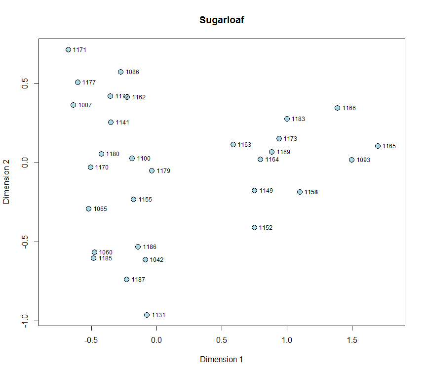
Figure 1. Plot of Dimension 1 by Dimension 2 scores for assemblages from Sugarloaf.
DAACS staff aim to produce a seriation-based chronology for each site using the same methods (see Neiman, Galle, and Wheeler 2003 for technical details). The use of common methods for all sites in the archive is designed to increase comparability among temporal phases at different sites. The methods they produced are summarized below. Archive users may also use the Mean Ceramic Date queries provided on the Query the Database section of this website to calculate MCDs for individual contexts or features.
DAACS Seriation Method
As with other sites in the Archive, the seriation chronology for Sugarloaf was derived from ceramic assemblages of individual contexts not assigned to stratigraphic groups.
No stratigraphic groups were assigned for the contexts included in the seriation at the time of writing. To reduce the noise introduced by sampling error, only ceramic assemblages with more than five sherds were included. The seriation chronology presented here is the result of a correspondence analysis (CA) of ware-type frequencies from contexts that meet these requirements.
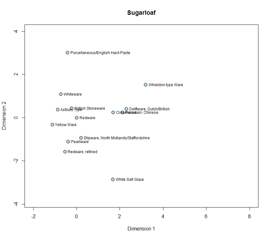
Figure 2. Sugarloaf Ceramic Ware Types.
Incorporating data from the DAACS database, we perform the correspondence analysis using the R programming language (R Core Team 2014). The CA code was written by Fraser D. Neiman. The following packages generate the data tables, CA, and plots within this code: RPostgreSQL (Conway et al 2013), plyr (Wickham 2011), reshape2 (Wickham 2007), seriation (Hahsler et al. 2014), anacor (de Leeuw and Mair 2009), and ggplot2 (Wickham 2009).
All of the R code used in this analysis was written within the domain of the R Core Team at the R Foundation for Statistical Computing, Vienna, Austria (2014). The correspondence analysis for Sugarloaf was conducted by Lynsey Bates.
The CA results produced a correlation between Dimension 1 scores and MCDs, suggesting that Dimension 1 represents time from right (early) to left (late). Based on the dips in ceramic counts observed in a histogram of Dimension 1 scores, where the vertical axis measures ceramic assemblage size, we divided the Sugarloaf into two occupational phases (Figure 3).
Sugarloaf Site Phases
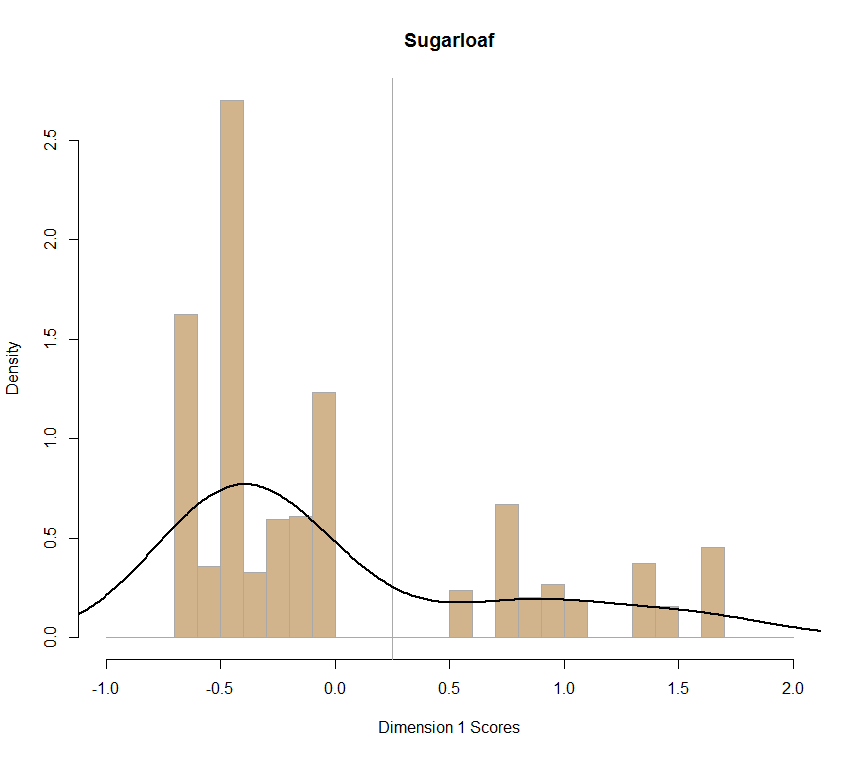
Figure 3: Histogram of ceramic counts plotted along CA Dimension 1. Lines indicate DAACS Phase Divisions with Phase 1 on right and Phase 2 on left.
DAACS Phases are groups of assemblages that have similar correspondence-analysis scores, similar MCDs, or both, and are therefore inferred to be broadly contemporary. Phases have a P-prefix that precedes the phase number (e.g. P01 equals Phase 1). Based on the correspondence analysis DAACS divided the Sugarloaf occupation into two phases (Figures 3 and 4). Mean ceramic dates for the site-specific phases are given in the table below.
The table below includes the site-wide Mean Ceramic Date and the BLUE MCD, which gives less influence to ceramic types with long manufacturing spans. The dates point to the occupation’s temporal placement the first quarter of the nineteenth century. It also provides three TPQ estimates. The first TPQ estimate is the usual one – the maximum beginning manufacturing date among all the ware-types in the assemblage. The second estimate — TPQp90 — is the 90th percentile of the beginning manufacturing dates among all the sherds in the assemblage, based on their ware-types. The TPQp95 provides a robust estimate of the site’s TPQ based on the 95th percentile of the beginning manufacturing dates for all the artifacts comprising it. These last two TPQ estimates are more robust against excavation errors and taphonomic processes that might have introduced a few anomalously late sherds into an assemblage.
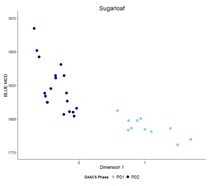
Figure 4. Plot of Blue MCDs by Dimension 1 scores for Sugarloaf phased assemblages.
Sugarloaf MCDs and TPQs
| Phase | MCD | BlueMCD | TPQ | TPQ90 | TPQ95 | Total Count |
|---|---|---|---|---|---|---|
| P01 | 1790.8 | 1792.4 | 1820 | 1820 | 1775 | 160 |
| P02 | 1845.0 | 1820.8 | 1830 | 1820 | 1820 | 480 |
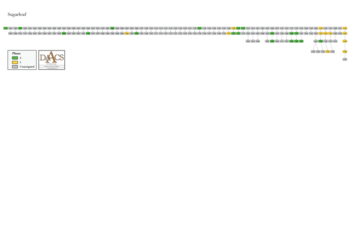
Sugarloaf Harris Matrix
The Harris Matrix summarizes stratigraphic relationships among excavated contexts and groups of contexts that excavators and DAACS staff have identified as part of the same stratigraphic group. Stratigraphic groups and contexts are represented as boxes, while lines connecting them represent temporal relationships implied by the site’s stratification, as recorded by the site’s excavators (Harris 1979).
Boxes with color fill represent contexts with ceramic assemblages large enough to be included in the DAACS seriation of the site. Their seriation-based phase assignments are denoted by different colors to facilitate evaluation of the agreement between the stratigraphic and seriation chronologies. Grey boxes represent contexts that were not included in the seriation because of small ceramic samples.
See the Sugarloaf Chronology page for stratigraphic and phase information. Please note that some of the contexts present in the chronology analysis are not visualized on the Harris Matrix. The contexts that are not included do not have any stratigraphic relationships with other contexts. The lack of relationships can occur for a few reasons but two common examples are 1) the artifacts are from a surface collection, which is entered into DAACS as a context but does not have recorded relationships to other contexts that are below it; 2) in cases where topsoil and plowzone are stripped and discarded, there may be features below the plowzone that are comprised of a single context. Since the plowzone does not exist as a documented context with artifacts, it cannot seal the single-context feature. DAACS also does not record subsoil as a context, so there is nothing for that single context feature to intrude or seal.
This Harris Matrix is based on data on stratigraphic relationships recorded among contexts in the DAACS database. It was drawn with the ArchEd application. See http://www.ads.tuwien.ac.at/arched/index.html.
For a printable version, download the Harris Matrix [0.25 MB PDF]


PDF of Sugarloaf site map.
Harris, Edward C.
1979 Principles of Archaeological Stratigraphy. Academic Press, London, England.