
| Location: | Monticello, Charlottesville, VA, United States |
|---|---|
| Occupation Dates: | c.1768 |
| Excavator(s): | William Kelso. |
| Dates excavated: | 1979-1981. |

Overview
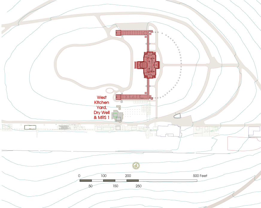
Location of West Kitchen Yard project area.
The West Kitchen Yard, located between Monticello mansion’s South Pavilion and Mulberry Row, was excavated by the Monticello Department of Archaeology under the direction of Dr. William Kelso between 1979 and 1982. Excavations revealed four prominent features: a deep circular pit (F01) which Kelso identified as a dry well; a ditch extending south from the South Pavilion (F05) to Mulberry Row; a stone foundation designated Mulberry Row Structure 1 (MRS-1) (F11), and the end of a second ditch (F17) which is almost certainly the remains of a ha-ha that enclosed the lawn on the west side of Monticello mansion. The width the MRS-1 stone foundation suggests that the structure it carried was masonry, similar in appearance to to the 1809 Stone House which stood just across Mulberry Row. A scatter of domestic artifacts in and around the structure indicate it was a dwelling, presumably for slaves.
Documentary evidence
There is no known documentary evidence concerning two of the four major features in the West Kitchen Yard: MRS-1 stone foundation (F11) and the ditch (F05). However, a letter written by Jefferson to his daughter in 1814 documents the construction of the ha-ha (F17) (Jefferson 1814). In addition, documents offer clues about the construction and function of the Dry Well (F01) south of the South Pavilion.
Several conjectural drawings by Jefferson dating to the 1770s depict a “dry well” in the same location as the pit (Kelso 1997: 38). A hand-drawn sketch from about 1770 shows an L-shaped wing, comprised of an above-ground covered passage extending to the south from South Pavilion and leading to a row of connected dependencies stretching to the west (Jefferson: N59). The rooms labeled on this plan include a laundry, dairy, smokehouse, storeroom, hen house, cook’s room, and dry well. A scale drawing, perhaps created shortly after this sketch, documents a similar plan (Jefferson: N32). The dry well is the only part of this plan found to have been constructed in the location depicted. However, some of the other structures drawn on it may lie undetected outside the limits of excavation to the west.
The term “dry well” appears on a list of windows needed to construct the dependencies, written about 1771 (Jefferson: N107). Similarly, the next page in Jefferson’s building notebook includes a notation for cutting stones for steps in a dry well. Jefferson indicates 19 stones to be cut, each measuring nine inches high, nine inches wide, and two and a half feet long (Jefferson: N106). No archaeological evidence was found to indicate that these windows or steps were installed in the Dry Well.
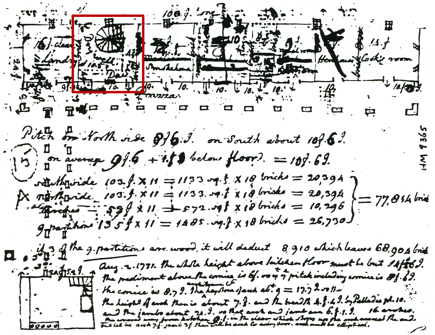
Jefferson’s sketch of L-shaped dependencies connected to the South Pavilion (Jefferson: N59).
In an entry in his Memorandum Book from December 1770, Jefferson documented the construction process:
“in digging my dry well, at the depth of 14f. I observed one digger, one filler, one drawer at the windlass with a basket at each end of his rope very accurately gave one another full emploiment [sic] but note it was a yellow rotten stone with a great many hard stones as large as a man’s head and some larger, or else the digger would have had time to spare. They dug and drew out 8. cubical yds in a day” (Bear and Stanton 1997:37).
Early in the 1770s, Jefferson abandoned the scheme for an L-shaped wing running south and then west of the South Pavilion, as shown in N32 and N59. His new vision retained the L-shaped configuration, but used it to link the mansion to the extant south pavilion and the planned north pavilion. A measured plan drawing from the 1770s shows an early and unexecuted version of this new scheme (Jefferson: N56). A dry well appears in the south wing and notes about its planned depth and construction appear on the reverse of drawing N56 and on the reverse of N60: “Dry well 16. f below floor of offices, (if of brick…20,864 [bricks])”. So at this stage it seems that Jefferson planned to fill the existing dry well and create a new one in the new south wing. However, this plan was not realized.
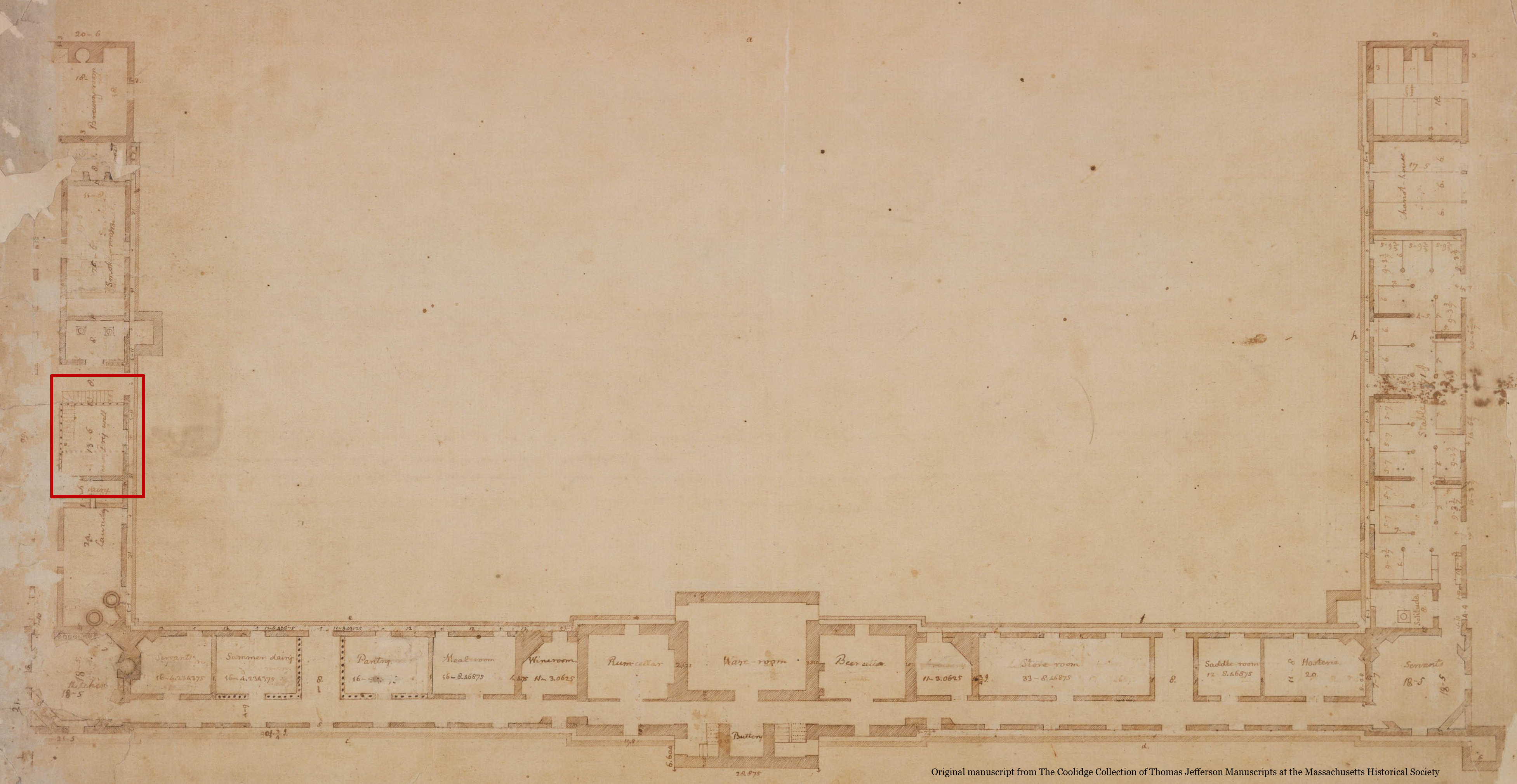
Jefferson’s plan drawing of Monticello Mansion with a dry well labeled in the South Dependency wing (Jefferson: N56).
In the late 1790’s, Jefferson began to rebuild the mansion, doubling its size and connecting it to the old South Pavilion and the newly constructed North Pavilion with L-shaped wings that were much simpler than the versions Jefferson had draw in the 1770s. When the wings were finally built, a dry well was not included in them, possibly because its function was now served by basements under the enlarged mansion and an ice house dug under the new north wing.
Excavation history, procedure and methods
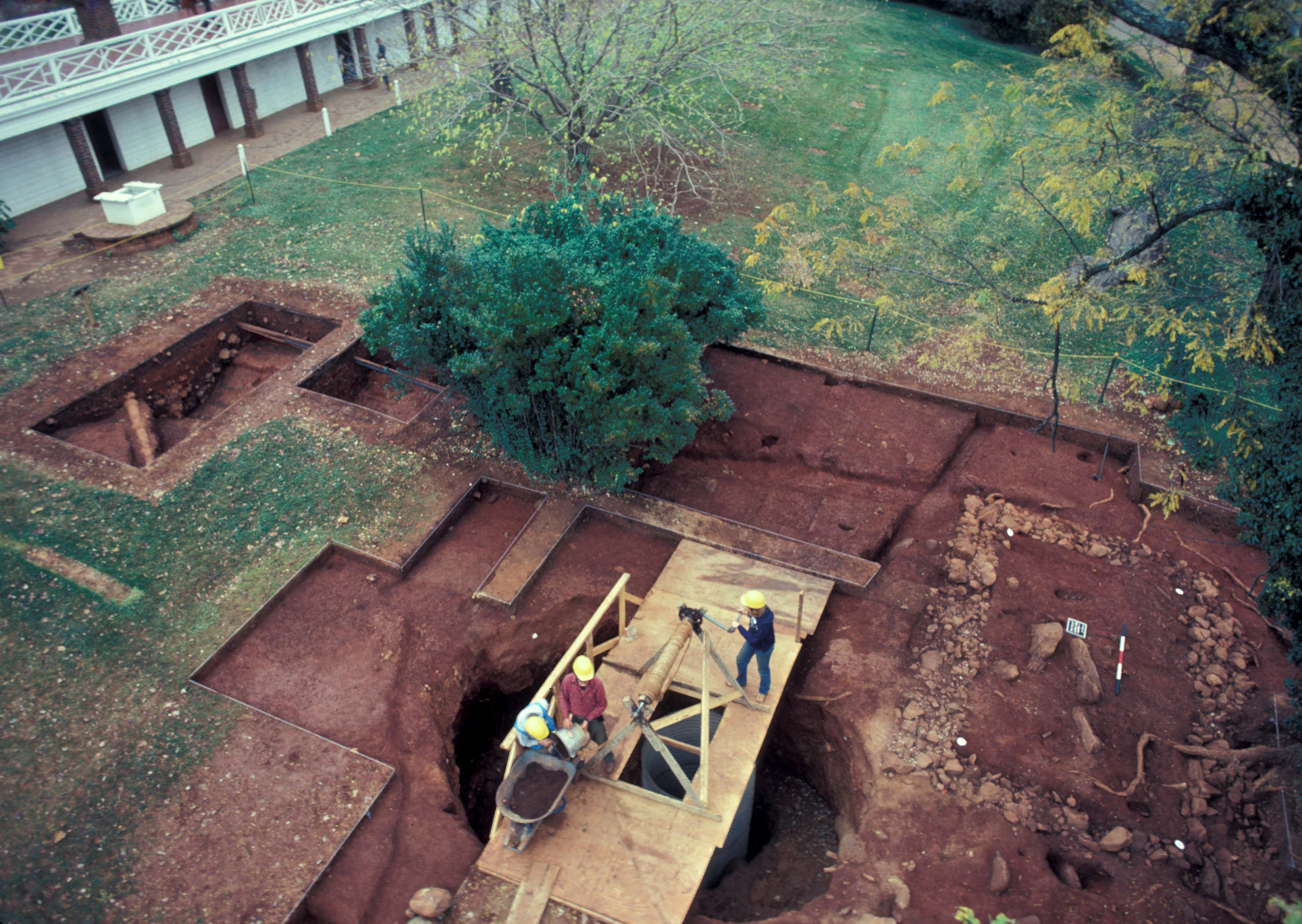
Beginning in 1979, William Kelso dug several large test trenches, aligned east-west, in the West Kitchen Yard area. He encountered and identified the four large features: the Dry Well (F01); the linear ditch (F05); the stone foundation (F11), designated Mulberry Row Structure 1 (MRS 1), and the ha ha (F17). The following season (1980), block excavations were conducted using the Wheeler Box method, with 8-by-8-foot units and 2-foot balks.
The Dry Well and the ditch feature were fully excavated during the 1980-1981 excavations. In the same season, MRS1 (F11) was completely exposed and at least four samples of the foundation were removed, one from each of the four walls. Dry Well (F01) deposits were divided into contexts within four test units and four balks. The balks in this feature were partially excavated and then divided into, and excavated with, their respective adjoining units.Artifacts were recovered by troweling. Sediments were not dry-screened. However, several small samples of fill from the dry well were floated and/or water screened.
Excavation history, procedure, and methods
Beginning in 1979, William Kelso dug several large test trenches, aligned east-west, in the West Kitchen Yard area. He encountered and identified the four large features: the Dry Well (F01); the linear ditch (F05); the stone foundation (F11), designated Mulberry Row Structure 1 (MRS 1), and the ha ha (F17). The following season (1980), block excavations were conducted using the Wheeler Box method, with 8-by-8-foot units and 2-foot balks.
Partially excavated MRS 1 (F11) foundation.
The Dry Well and the ditch feature were fully excavated during the 1980-1981 excavations. In the same season, MRS1 (F11) was completely exposed and at least four samples of the foundation were removed, one from each of the four walls. Dry Well (F01) deposits were divided into contexts within four test units and four balks. The balks in this feature were partially excavated and then divided into, and excavated with, their respective adjoining units.Artifacts were recovered by troweling. Sediments were not dry-screened. However, several small samples of fill from the dry well were floated and/or water screened.
Summary of research and analysis
The West Kitchen Yard is among the most stratigraphically complex areas excavated on Monticello Mountain. That complexity has given rise to at least two narratives.
Kelso:
Kelso interpreted the West Kitchen Yard area as a work yard that was not formally landscaped (Kelso 1997:36). He concluded that the excavated Dry Well was the same dry well that appeared on Jefferson’s early dependency plans (see Documentary Evidence above). He argued that it was filled soon after it was initially constructed, likely during 1771. He cited erosion and back-fill “layers” within the shaft which contained artifacts that dated no later than 1771 (Kelso 1997:40).
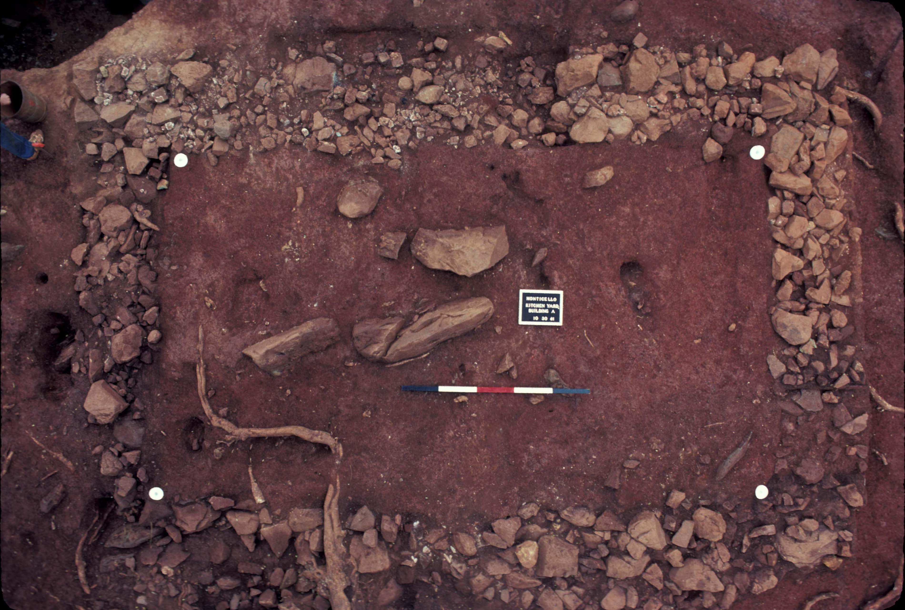
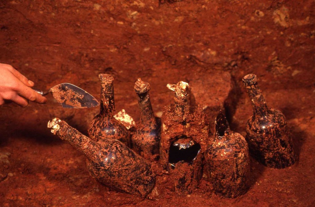
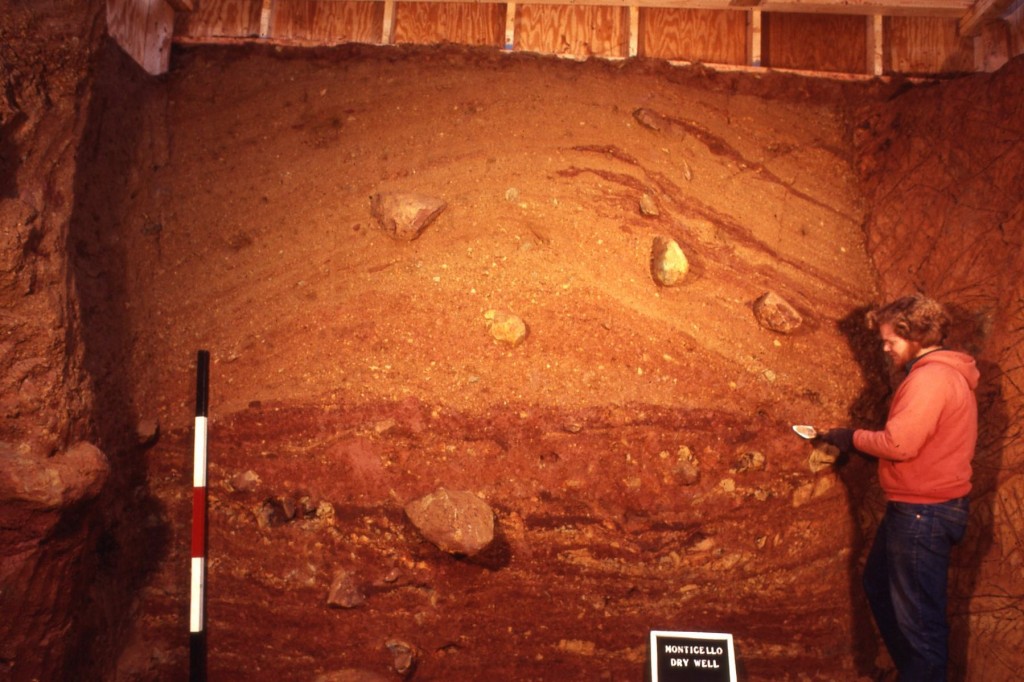
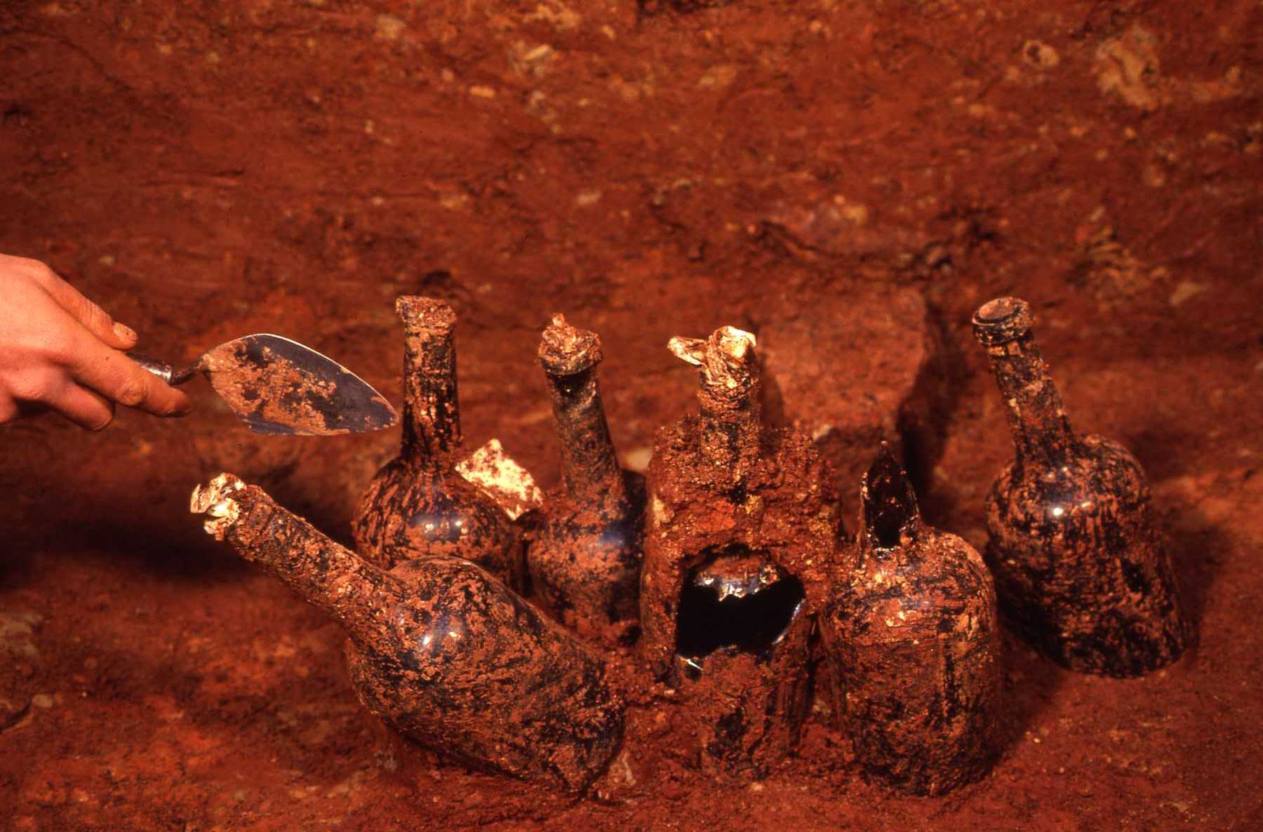
The archaeologically excavated Dry Well appears unfinished compared to the dry well in the historical documents. While the sides were squared off and the subsoil floor was intact, no evidence of stairs, brick lining, or any covering as shown in the drawings was found. However, the historically recorded depth of 16 feet is fairly close to the excavated 19 foot depth of the dry well, the difference partially accounted for by a layer of overburden from the later leveling of the kitchen yard. Finally, six wine bottles containing preserved cherries found in situ on the subsoil floor attest to the use of the dry well for food storage (Kelso 1997: 41).
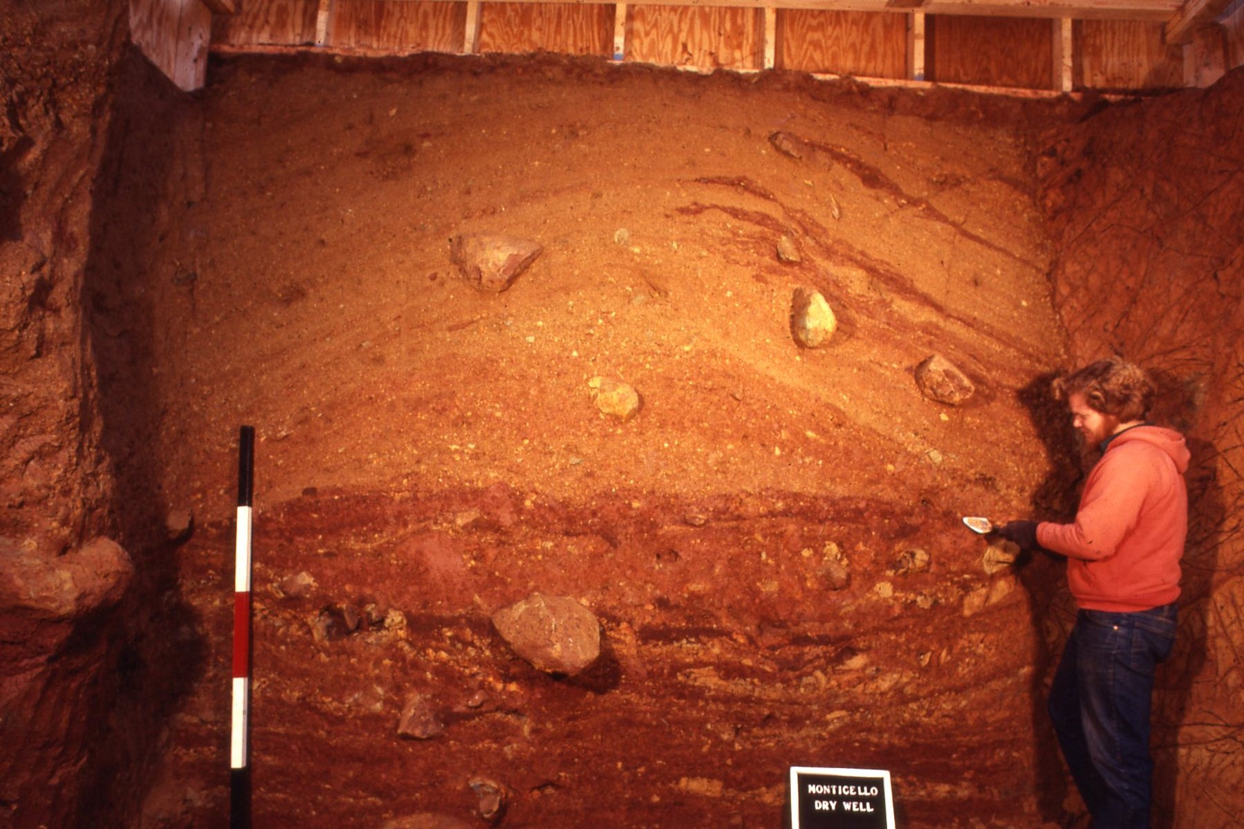
Post-excavation profile of the dry well.
Kelso identified the ditch feature (F05) as the eroded end of a ha-ha, a landscape boundary feature which enclosed Monticello Mansion’s west lawn and the adjacent yards (Kelso 1997: 38). He suggested that this feature may have acted as drainage for the early Jefferson kitchen yard and then became part of the “ha-ha system” after the yard was “raised with redeposited subsoil” (Kelso 1997:42). Kelso described the “mysterious” MRS-1 (F11) as a stone building with a foundation in line with the South Pavilion and the 1809 Stone House on Mulberry Row on Mulberry Row (Kelso 1997: 42). Given the presence of hand-painted pearlware in the construction deposits of the building, Kelso suggested it was built after 1785 (Kelso 1997: 43).
Finally, Kelso noted the presence of an original living surface. He described this zone as “a three- to four-inch thick layer of dark organic soil containing wood ash and artifacts…found at a depth of three feet near the [South] pavilion and one foot eight inches at the edge of the dry well” (Kelso 1997: 39). This “leveled eighteenth-century yard” was in line with Jefferson’s original kitchen, “placing the dry well surface and the kitchen floor/doorway on an even plane” (Kelso 1997: 39). When Jefferson’s plans for the dependencies changed, the leveled kitchen yard area became “unnecessary” and was subsequently filled or raised to its current elevation (Kelso 1997: 42).
In conjunction with Kelso’s research, Diana Crader (1984) conducted a comparative study of the faunal material from Building l on Mulberry Row and the Dry Well. Crader argued the Dry Well faunal assemblage represented meals from Jefferson’s table, while the Building l assemblage represented the meals of its enslaved residents (Crader 1984:550). Crader suggested that the relative frequency of pig and sheep bones, the low degree of fragmentation, and the representation of particular body parts in the dry well illustrated the greater wealth and social status of the Jefferson household (Crader 1984:552, 555-556).
Hill:
In 2002 Martha Hill compiled a thorough review of architectural studies, archaeological excavations, documentary sources, and Thomas Jefferson Foundation research that pertained to Mulberry Row and other mountaintop outbuildings. Hill supported Kelso’s interpretation of the Dry Well as a storage feature that was part of Jefferson’s original dependency plans. However, she questioned Kelso’s interpretation of the ditch (F05) as a drainage area and ha-ha, citing the high frequency of artifacts in the fill that date prior to 1814, which documentary evidence suggests was the construction date of the ha-ha encircling the lawn to the west of the mansion (Hill 2002a (11: Section 22, 2).
Hill suggested that the ditch was actually a sunken foot path running from Mulberry Row to the original doorway of Jefferson’s first kitchen on the ground floor of the South Pavilion. She also suggested that the ditch was created not by digging, but by piling sediment on either side of an established path. The sediment was backdirt from the cut into the slope to the west, required to build the South Terrace and its dependency rooms, starting around 1800. The path made it possible to continue to use the kitchen on the ground floor of the South Pavilion while the South Terrace was under construction When construction of the terrace, including a new kitchen in its east end, was completed around 1809, the sunken path was filled (Hill 2002a (11): Section 23, 3).
Because the foundation of MRS-1 (F11) overlay the fill of the ditch (F05), Hill concluded that the construction of MRS-1 post dated completion of the South Terrace around 1809 (Hill 2002a (11): Section 23, 3). She noted that a Jefferson plat of the mountaintop supported this idea (Jefferson: N225). The plat shows the 1809 Stone House, just opposite MRS-1 on Mulberry Row, but not MRS 1, suggesting that MRS 1 had not yet been built. The fact that the ha-ha (F17) stops 14 feet short of the west side of MRS-1 suggests that MRS1 was standing when the ha-ha was dug. This would put the construction of MRS-1 sometime between 1809 and 1814.
DAACS:
In 2007 Monticello archaeology department staff used DAACS protocols to digitize artifacts and context records from Kelso’s excavation, as part of the Mulberry Row Reassessment. Using the resulting data, Sawyer (née Clites) and Bates (2008a, 2008b) employed correspondence analysis of DAACS MCD-type frequencies to produce a relative chronology of assemblages in layers associated with the Dry Well (F01), the ditch (F05), MRS-1 (F11), and the ha-ha (F17). Their chronology confirmed that the Dry Well was the earliest of the four major features, followed by the ditch, and then MRS 1. They also showed that the MRS-1 assemblages were contemporary with a small assemblage from the ha-ha (F17). This chronological order supports Hill’s interpretation of the site.
Bates and Sawyer (née Clites) noted that that mean ceramic dates for the assemblages did not match Hill’s dates for the features, based on documents. This discrepancy may be due to at least two factors. First, the events being dated are different. The target events in Hill’s analysis were construction and abandonment of the features, while the target events for the MCD and CA results were the means of the periods over which the ceramic assemblages accumulated. Second, mean ceramic dates are not calendar-year dates. These differences deserve further systematic exploration.
Lynsey Bates, Elizabeth Sawyer (née Clites), and Fraser Neiman
Thomas Jefferson Foundation
May 2013
Things you need to know about the West Kitchen Yard before you use the data:
- The entire site was carefully hand-troweled and screens were not used for artifact recovery.
- Measurements are in feet and tenths of feet.
- The West Kitchen Yard was excavated using the Wheeler Box excavation system of 8-by-8 foot quadrats with 2-foot balks. This system was later expanded to 10-by-10 foot quadrats, resulting in a miscellany of different-sized quadrats. Unit size varies from 4-by-8 foot quadrats to 10-by-10 foot quadrats. Balk 354/355 is L-shaped. In addition, the test trenches (Units 206, 264, 265, 271, 273, 274, 279, and 281) dug in 1979 are of various sizes and shapes, ranging from long 3-by-20 foot trenches to 10-by-8 foot rectangles.
- Modern intrusions in the area include several utility trenches (F02, F03, and F20), part of a road bed (Context 281TPS), a planting bed (F16), and root disturbances.
- Excavators recorded two deposits as “kitchen yard trash” or “kitchen yard fill.” Given the presence of plowscars associated with these deposits, DAACS recorded these deposits as upper and lower plowzones, representing distinct plowing episodes.
- Several float samples from dry well context 357AC are in the process of being sorted and catalogued. These data will be made available upon completion.
- During excavation, some lapses in stratigraphic control occurred. Notably, the narrow, trough-like feature on the interior of the MRS-1 north wall was removed with the building foundation adjoining it and was not designated as an independent feature.
Feature Numbers
The original excavators of the West Kitchen Yard did not assign numbers to individual features. Monticello Archaeology Department staff assigned feature numbers using the original excavation records. Feature Numbers assigned by Monticello have an F-prefix, which precedes the number (i.e. F01 equals Feature 1).
Excavated contexts that belong to the same depositional basin (e.g. a posthole and postmold or the layers in a single pit) have been assigned a single feature number. In addition, single contexts have been given feature numbers when the original field records indicate that the excavators recognized a context’s spatial distinctiveness from surrounding contexts.
| Feature | Feature Type | Contexts |
|---|---|---|
| F01 | Dry Well | 354/357G, 354/357H, 354/357J, 356/357C, 356/357D, 357D, 352/356G, 352G, 352K, 352L, 352M, 352N, 352P, 352AB, 352AC, 352AD, 352/353C, 352/353D, 352/354E, 352H, 352/356D, 352/356E, 354E, 354F, 354G, 354H, 352/354F, 352/356C, 352/464B, 354K, 354L, 354M, 354N, 354P, 354AB, 354AC, 354AD, 354/355D, 354/357E, 354/357F, 356C, 356E, 356F, 356G, 356AB, 356AC, 356AD, 352/356H, 352J, 357F, 357G, 357H, 357J, 357AB, 357AC, 357AD, 206C, 206D, 265C, 265D |
| F02 | Trench, utility | 357B, 352/354A, 353/355A, 353C, 354A, 354/355A, 354/357A, 370B, 370/373B, 373B, 466A |
| F03 | Trench, utility | 353A, 468A, 464B, 464/521A |
| F04 | Posthole, possible | 358D, 358E |
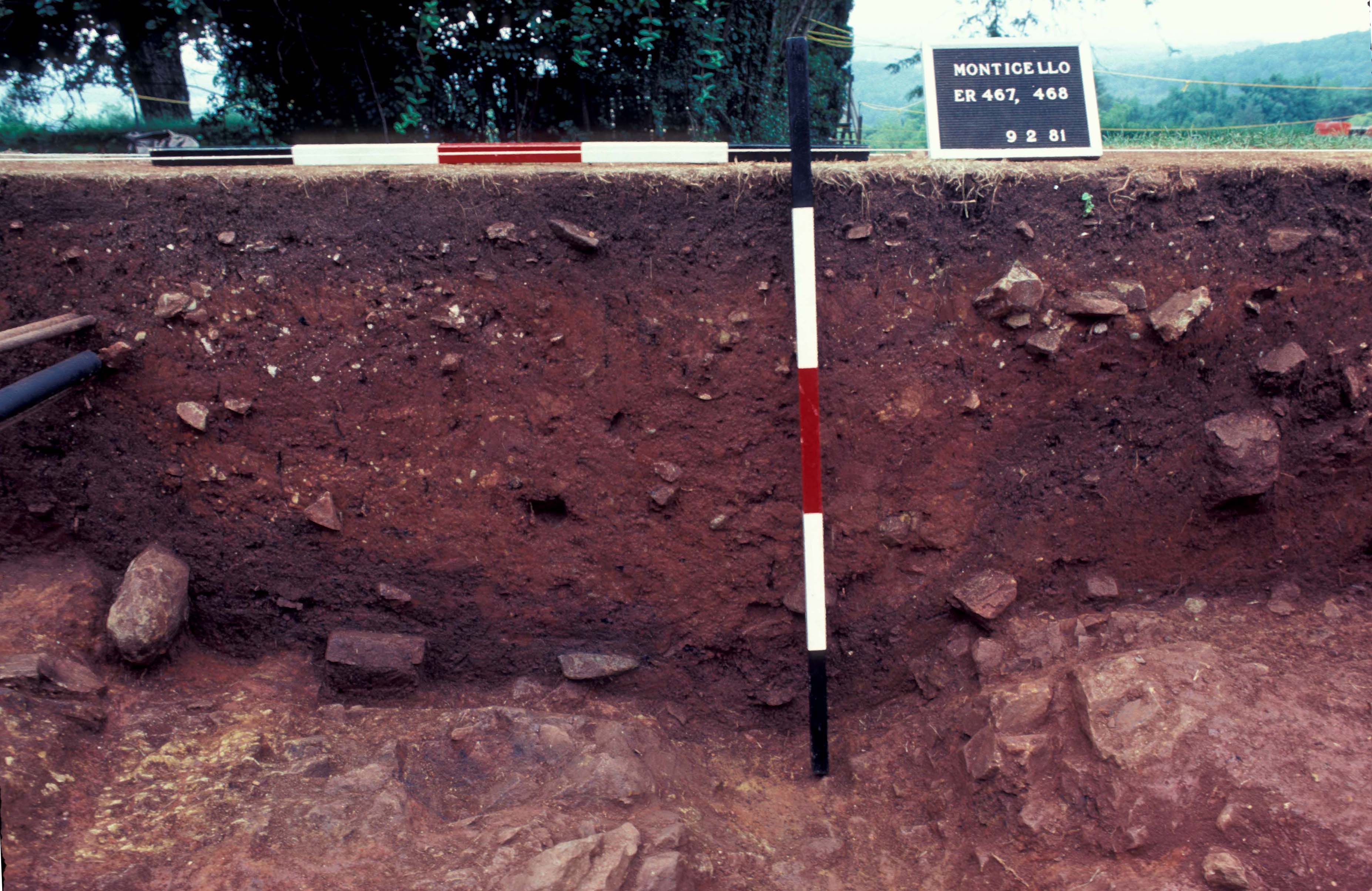
| F05 | Trench, unidentified | 359D, 359E, 359/372B, 359/372C, 370E, 370F, 370/373E, 370/373F, 371D, 372C, 265F, 265G, 273H, 461F, 461G, 461H, 461J, 461K, 467C, 467D, 467E, 467F, 467/468C, 463E, 463F, 466E, 466F, 468C, 468E, 468F |
| F06 | Posthole | 352/356F |
| F07 | Posthole, possible | 354J |
| F08 | Unidentified | 355C |
| F09 | Unidentified | 355D |
| F10 | Posthole, possible | 355F |
| F11 | Trench, builder’s | 357E, 357/358B, 357/358C, 357/358D, 358/379C, 358/379D, 358/379E, 370/371B, 370/371C, 370/371D, 370/371E, 371/378B, 371/466B, 371/466C, 371/466D, 378F, 378J, 378K, 378L, 378M, 273E, 273F, 378/460D, 378/463B, 460B, 460/462B, 462C, 463/466B |
| F12 | Posthole | 370D |
| F13 | Posthole | 372B |
| F14 | Posthole, possible | 372D |
| F15 | Posthole, possible | 373D |
| F16 | Planting Bed | 378A, 378/460A, 463C |
| F17 | Ditch, other | 264C, 271C |
| F18 | Posthole | 281D |
| F19 | Posthole, possible | 379D |
| F20 | Trench, utility | 461A, 467A |
| F21 | Posthole, possible | 462D |
| F22 | Posthole, possible | 466D |
| F23 | Unidentified | |
| F24 | Floor, clay | 358C, 371C, 273J |
DAACS Seriation Method
Monticello Archaeology Department staff produced a seriation-based chronology for the West Kitchen Yard area (see Neiman, Galle, and Wheeler 2003 for technical details). The ceramic assemblages used in the seriation were from individual stratigraphic groups, or groups of contexts that field records indicate were part of a single stratigraphic layer or deposit, and from individual contexts that were not assigned to stratigraphic groups. Stratigraphic groups have an SG-prefix, which precedes the group number (e.g. SG01 equals Stratigraphic Group 1). Only assemblages with more than three ceramic sherds were included in the seriation.
Monticello archaeologists computed the frequency of mean-ceramic-date (MCD) types in each stratigraphic group and each individual context that had no stratigraphic group assignment. The seriation chronology is derived from a correspondence analysis of these MCD-type frequencies. Seriated stratigraphic groups and contexts were assigned to phases. Phases are groups of assemblages that have similar correspondence analysis scores and are therefore inferred to be broadly contemporary. Phases assigned by Monticello have a P-prefix that precedes the phase number (e.g. P01 equals Phase 1).
The stratigraphic relationships among stratigraphic groups and unassigned contexts are summarized in the Harris Matrix for the site. Phase assignments from the seriation are shown on the Harris Matrix in color, facilitating comparison of the seriation chronology and the stratigraphic chronology of the site.
West Kitchen Yard Site Phases
Based on the correspondence analysis, Monticello archaeologists divided the West Kitchen Yard occupation into five phases. Mean ceramic dates (MCDs) for these phases are given in the table below. The table also includes two estimates of the TPQ for each phase. The first TPQ estimate is the usual one – the maximum beginning manufacturing date among all the MCD-types in the assemblage. The second estimate — TPQp90 — is the 90th percentile of the beginning manufacturing dates among all the sherds in the assemblage, based on their MCD-types. This TPQ estimate is more robust against excavation errors and taphonomic processes that might have introduced a few anomalously late sherds into an assemblage.
Phase 1 is composed primarily of the dry well (F01: SG16 through SG19, and SG21), which is the earliest and largest feature on the site. It also contains a possible buried-A horizon context (context 467G). Phase 2 is comprised of three additional dry well deposits (F01: SG13, SG14, SG20), and two possible buried-A horizon deposits (contexts 465E and 468H). The presence of both Phase 1 and Phase 2 deposits within the dry well is believed to be the product of secondary depositional processes, as discussed at length in Clites and Bates 2008a. Phase 3 includes assemblages from ditch fill (F05: SG23, SG24, SG25), one posthole (F13), and one other deposit (context 371/378C). Phase 4 primarily represents the final filling of the ditch (F05: SG22), the construction and destruction of MRS 1 (F11: SG26 thru SG29, SG12, SG09), the filling of the Ha-Ha (F17: SG11), several other small deposits, and the earlier of the two plowzones (SG10). Finally, Phase 5 is comprised of deposits that post-date Jefferson’s occupation of the mountaintop. These assemblages include the later plowzone (SG08), the area topsoil (SG01), several utility line trenches (F03, F02, F20), and two other small deposits (F09 and context 461C). Additional information on the establishment of these site phases and site chronology can be found in Clites and Bates 2008b.
A Seriation Chronology for the West Kitchen Yard
The following table presents a seriation chronology for the West Kitchen Yard area. We use the indefinite article to signify that it is not the only chronology possible, nor even the best one possible.
| Phase | MCD | TPQ | TPQp90 | Total Count |
|---|---|---|---|---|
| P01 | 1776 | 1840 | 1762 | 1306 |
| P02 | 1782 | 1840 | 1762 | 517 |
| P03 | 1788 | 1820 | 1775 | 1047 |
| P04 | 1807 | 1840 | 1810 | 8518 |
| P05 | 1829 | 1840 | 1820 | 15048 |
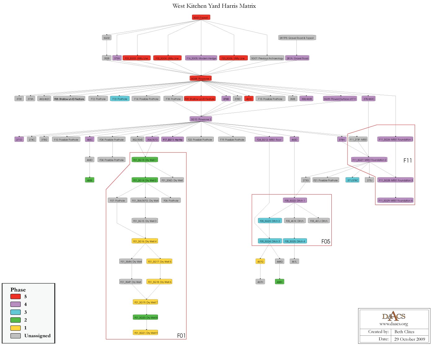
West Kitchen Yard Harris Matrix
The Harris Matrix summarizes stratigraphic relationships among excavated contexts and groups of contexts that Monticello Archaeology Department staff have identified as part of the same stratigraphic group. Stratigraphic groups and contexts are represented as boxes, while lines connecting them represent temporal relationships implied by the site’s stratification, as recorded by the site’s excavators (Harris 1979).
Stratigraphic groups, which represent multiple contexts, are identified on the diagram by their numeric designations (e.g. SG10) followed by the descriptions of them (e.g. “occupation zone”). Contexts that could not be assigned to stratigraphic groups are identified by their individual context numbers (e.g. 622A) or feature numbers (e.g. F08).
Boxes with color fill represent contexts and stratigraphic groups with ceramic assemblages large enough to be included in the DAACS seriation of the site. Their seriation-based phase assignments are denoted by different colors to facilitate evaluation of the agreement between the stratigraphic and seriation chronologies. Grey boxes represent contexts that were not included in the seriation because of small ceramic samples.
See West Kitchen Yard Chronology for stratigraphic and phase information. Please note that some of the contexts present in the chronology analysis are not visualized on the Harris Matrix. The contexts that are not included do not have any stratigraphic relationships with other contexts. The lack of relationships can occur for a few reasons but two common examples are 1) the artifacts are from a surface collection, which is entered into DAACS as a context but does not have recorded relationships to other contexts that are below it; 2) in cases where topsoil and plowzone are stripped and discarded, there may be features below the plowzone that are comprised of a single context. Since the plowzone does not exist as a documented context with artifacts, it cannot seal the single-context feature. DAACS also does not record subsoil as a context, so there is nothing for that single context feature to intrude or seal.
This Harris Matrix is based on data of stratigraphic relationships recorded among contexts in the DAACS database. It was drawn with the ArchEd application. See http://www.ads.tuwien.ac.at/arched/index.html.
For a printable version, download the Harris Matrix [376.33 KB PDF].


PDF of composite excavator’s plan, compiled by Monticello staff from original field drawings, with excavation units and features labeled.
PDF of composite excavator’s plan, compiled by Monticello staff from original field drawings, with only excavation units labeled.
PDF of composite excavator’s plan, compiled by Monticello staff from original field drawings, with only features labeled.
Bear, James A., Jr., and Lucia C. Stanton
1997 Thomas Jefferson’s Memorandum Books: Accounts, with Legal Records and Miscellany, 1767-1826. Two volumes. The Papers of Thomas Jefferson, 2d. Series. Princeton University Press, Princeton, New Jersey.
Crader, Diana C.
1984 The Zooarchaeology of the Storehouse and the Dry Well at Monticello., American Antiquity In American Antiquity 49(3): 542-557.
Harris, Edward C.
1979 Principles of Archaeological Stratigraphy. Academic Press, London, England.
Hill, Martha
2002a Summary of Archaeological Excavations by Site. Mulberry Row Project. Unpublished report on file at the Jefferson Library, Thomas Jefferson Foundation, Charlottesville Virginia.
Jefferson, Thomas
n.d. Monticello: dependencies (cross-section). N60; K33. Thomas Jefferson Papers: An Electronic Archive. Massachusetts Historical Society, Boston, MA. http://www.thomasjeffersonpapers.org
Jefferson, Thomas
1771 Monticello: building notebook, page 11 of 52. N107; K78. Thomas Jefferson Papers: An Electronic Archive. Massachusetts Historical Society, Boston, MA. http://www.thomasjeffersonpapers.org
Jefferson, Thomas
1770 Monticello: building notebook, page 10 of 52. N106; K77. Thomas Jefferson Papers: An Electronic Archive. Massachusetts Historical Society, Boston, MA. http://www.thomasjeffersonpapers.org
Jefferson, Thomas
THOMAS JEFFERSON, Poplar Forest, to MARTHA JEFFERSON. 1814 June 6. Coolidge Collection, Massachusetts Historical Society.
Jefferson, Thomas
1771 Studies for plans for dependencies with brick estimates. N59. CSmH9365. The Huntingrton Library, San Marino, CA.
Jefferson, Thomas
1809b Monticello: mountaintop (plat). N225; K169. Thomas Jefferson Papers: An Electronic Archive. Massachusetts Historical Society, Boston, MA. http://www.thomasjeffersonpapers.org
Jefferson, Thomas
n.d. Monticello: dependencies (study plan). N32; K10. Thomas Jefferson Papers: An Electronic Archive. Massachusetts Historical Society, Boston, MA. http://www.thomasjeffersonpapers.org
Jefferson, Thomas
n.d. Monticello: dependencies (plan). N56; K31. Thomas Jefferson Papers: An Electronic Archive. Massachusetts Historical Society, Boston, MA. http://www.thomasjeffersonpapers.org
Kelso, William M.
1997 Archaeology at Monticello: Artifacts of Everyday Life in the Plantation Community. Monticello Monograph Series. Thomas Jefferson Foundation, Charlottesville, Virginia.
Neiman, Fraser D., Jillian E. Galle , and Derek Wheeler
2003 Chronological Inference and DAACS. Unpublished paper presented at the annual meeting of the Society for Historical Archaeology, Providence, Rhode Island. On file at the Department of Archaeology, Thomas Jefferson Foundation, Charlottesville, Virginia.