| Location: | Monticello, Charlottesville, VA, United States |
|---|---|
| Occupation Dates: | c.1769-c.1826 |
| Excavator(s): | Dr. William Kelso, Dr. Susan Kern |
| Dates excavated: | 1980, 1981, 1984, 1989, 1993 |
Overview

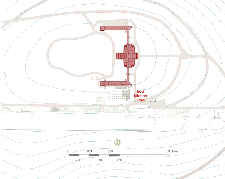
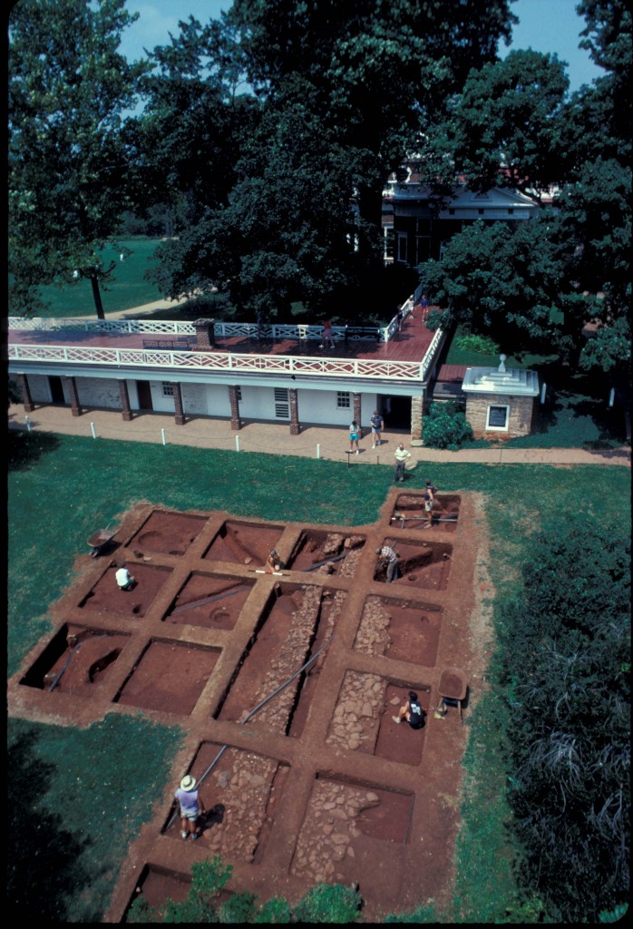
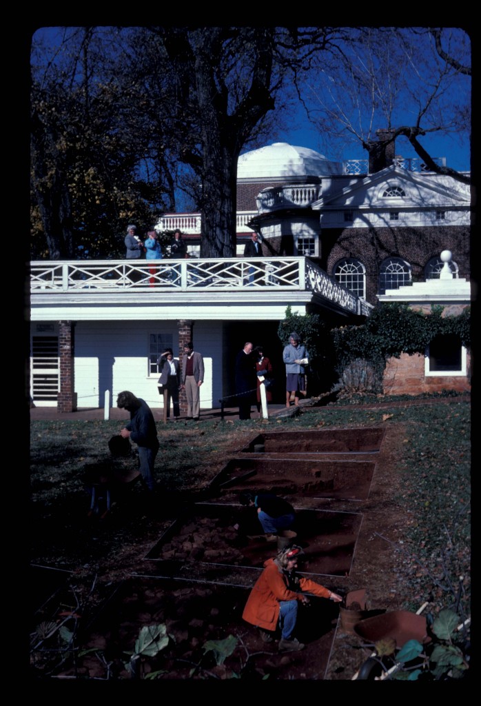
Location of project area.
The East Kitchen Yard, located between Monticello Mansion’s South Dependency wing and Mulberry Row, was excavated by William Kelso and Susan Kern during several field seasons between 1980 and 1994. The area is rich in artifacts and features, highlighting a landscape history spanning 200 years up to and including 20th century trenches. Kelso’s excavations exposed numerous features, including a large Jefferson-era cobble paving (F07) extending north-south through the excavation area. This pavement is probably the underlayment for a path that began at the All-Weather Passage southern entrance adjacent to the Monticello II kitchen, continued to Mulberry Row, and terminated at the terrace vegetable garden further south.
Documentary evidence
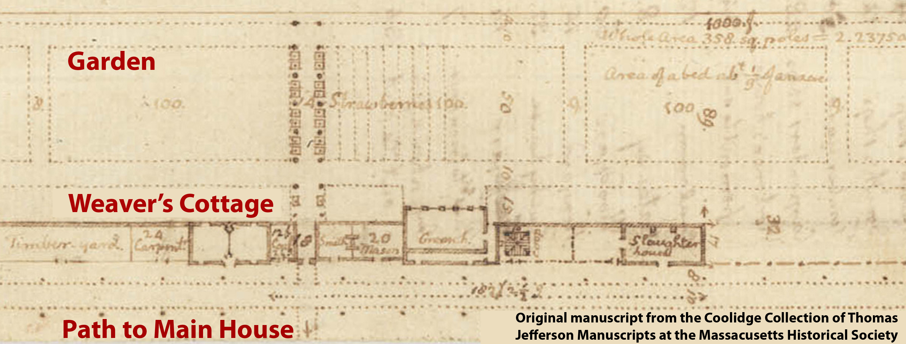
Plan drawing of Mulberry Row (Jefferson N87 c.1776-1778), oriented with north at the bottom.
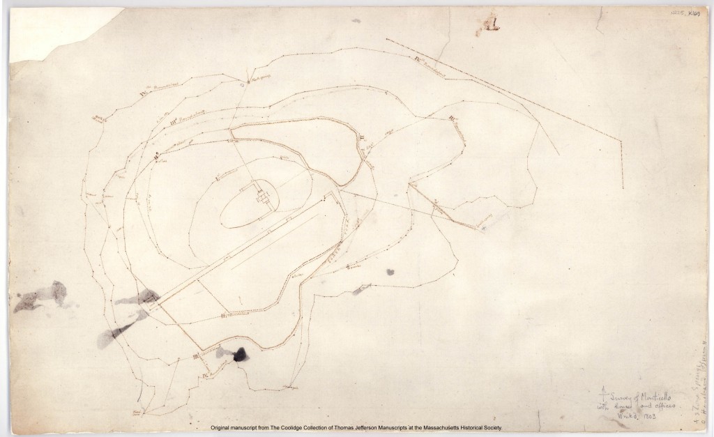
Jefferson-period documents relating directly to the East Kitchen Yard area are scarce. While there are several surveys, plats, and maps of the area, only one indicates the presence of any features south of the kitchen. In c.1776, Jefferson drafted a plan for Mulberry Row and the adjacent landscape (Jefferson: N87). Jefferson drew a path extending north from Mulberry Row in the direction of the main house, and south into the vegetable garden (image at right). Yet this is the only Jefferson document that records a path at this location.
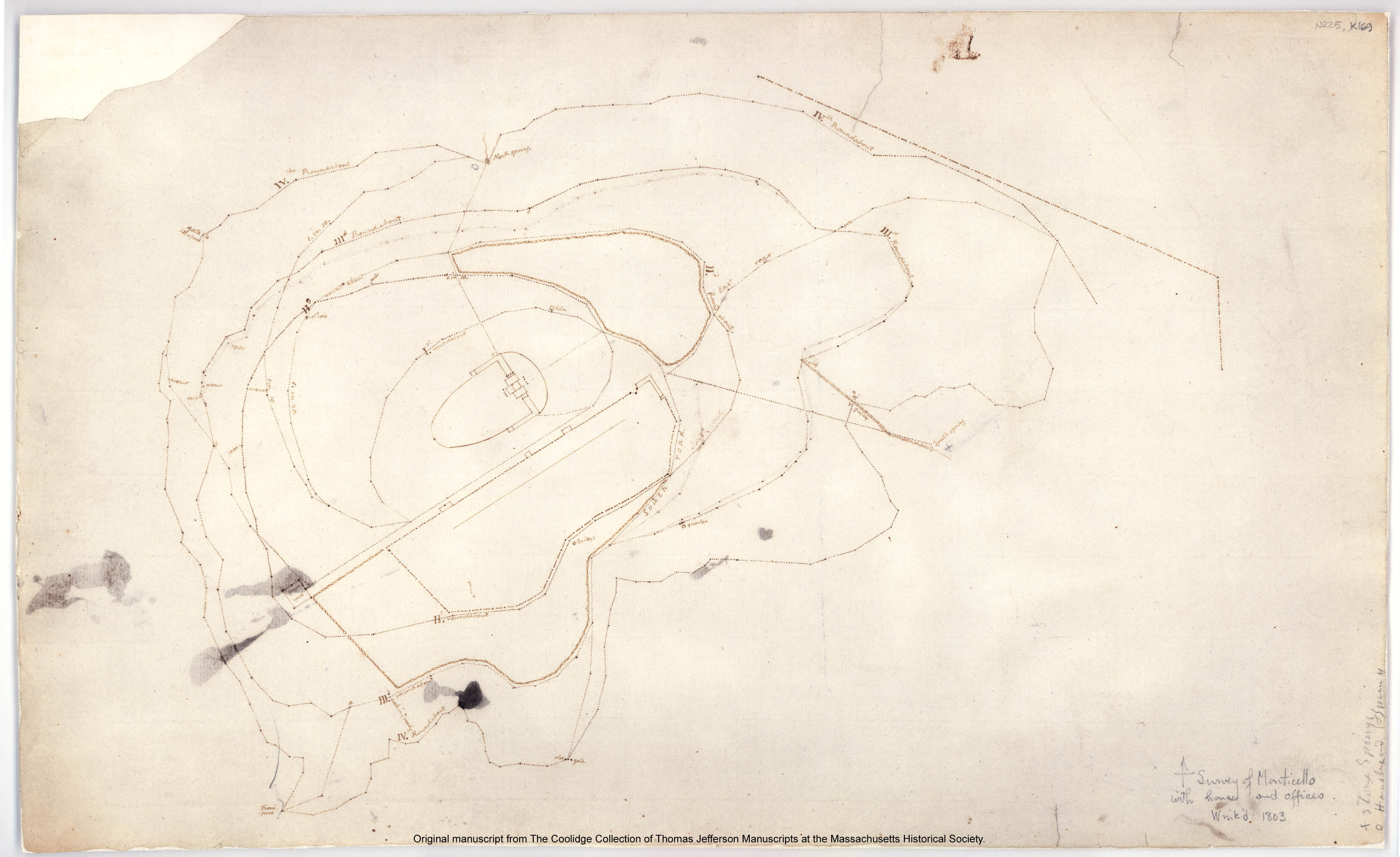
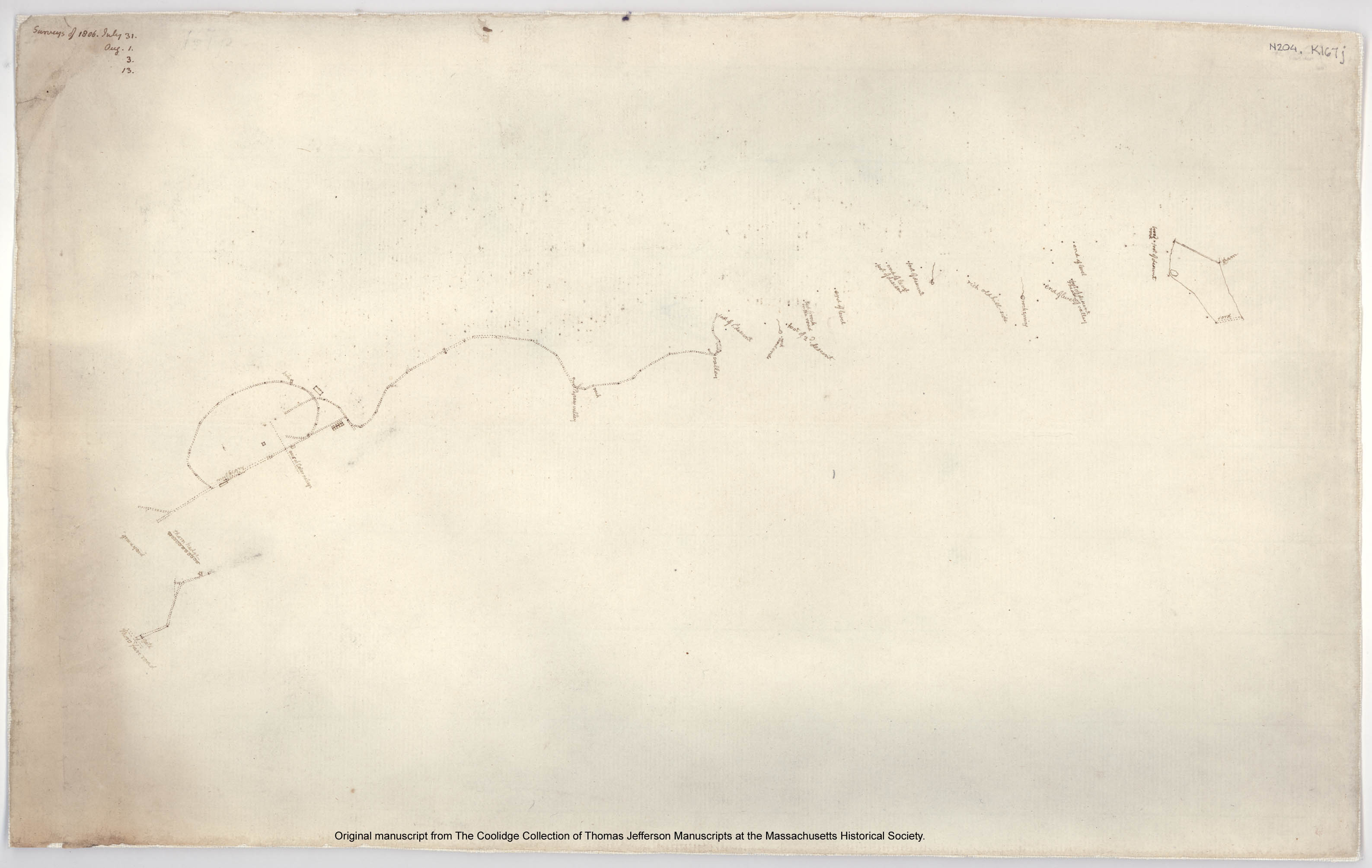
While one survey conducted in 1806 depicts a dotted line in roughly the same location as the path in document N87, it is labeled as an “axis of the cellar passage” and is likely just a reference used while conducting the survey (Jefferson: N204). After 1776, all plats and surveys with a road connecting Mulberry Row and the mansion depict a kitchen road extending at an angle, not at a straight line and not on axis with the main house (Jefferson: N203,N204, N225).
Historical documents pertaining to other features in the East Kitchen Yard are equally scarce. However, a few post-Jefferson documents do indicate that the area around the house, likely including the Kitchen Yard, underwent some alterations after Jefferson’s death. Much of the area was plowed during the years in which James Barclay owned Monticello from 1831 to 1834. In 1833 Martha Randolph wrote in a letter to a family member, “Barclay has… ploughed up the yard to the very edge of the lawn and planted it in corn” (Leepson 2001: 32). No other historical documents have been located pertaining to this area.
Excavation history, procedure and methods
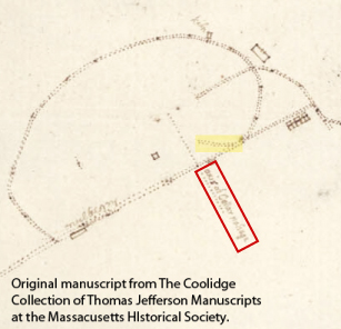
N204: Jefferson survey (c.1806) with “axis of cellar passage” outlined in red and angled kitchen road highlighted.
In 1980, 1981, 1984, 1985, and 1989, William Kelso conducted excavations in the East Kitchen Yard area. Only one unit (Quadrat 207) was excavated in 1980 as part of a sampling project of the mountaintop landscape. The following year thirty-one additional two-by-two-foot units were excavated throughout the kitchen yard. Quadrat 207 from the 1980 excavations and quadrats from the 1981 excavations revealed portions of a large stone paving (Feature 07). The 1984-1985 field seasons focused on exploring this feature through block excavations conducted using the Wheeler-Box method. These excavations uncovered the remainder of the stone paving as well as postholes and other features. The stone paving itself was only sampled in two small sections.
In 1993, Susan Kern excavated six ten-foot by eight-foot quadrats adjoining the brick walkway that parallels the South Dependency wing. Utility lines and trenches as well as deep fill were discovered. No identifiable Jefferson-period features were found in Kern’s excavations.
Summary of research and analysis
Kelso
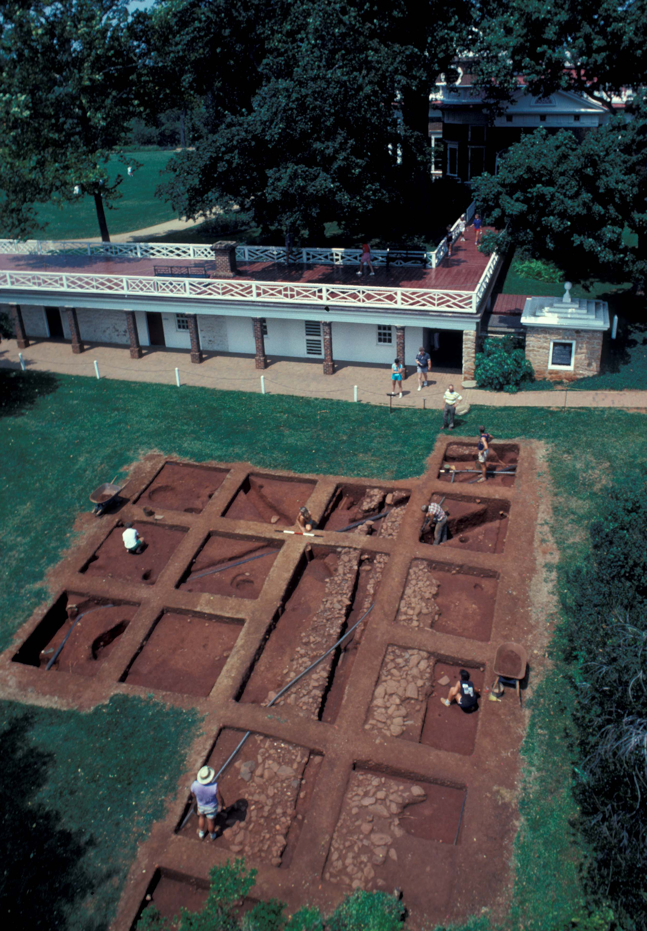
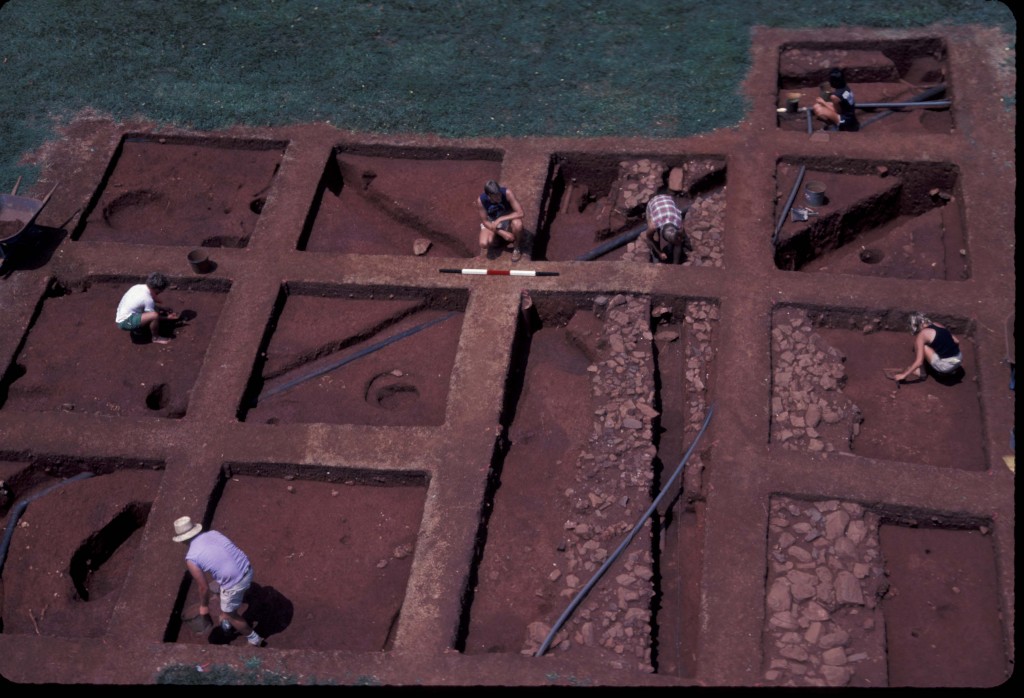
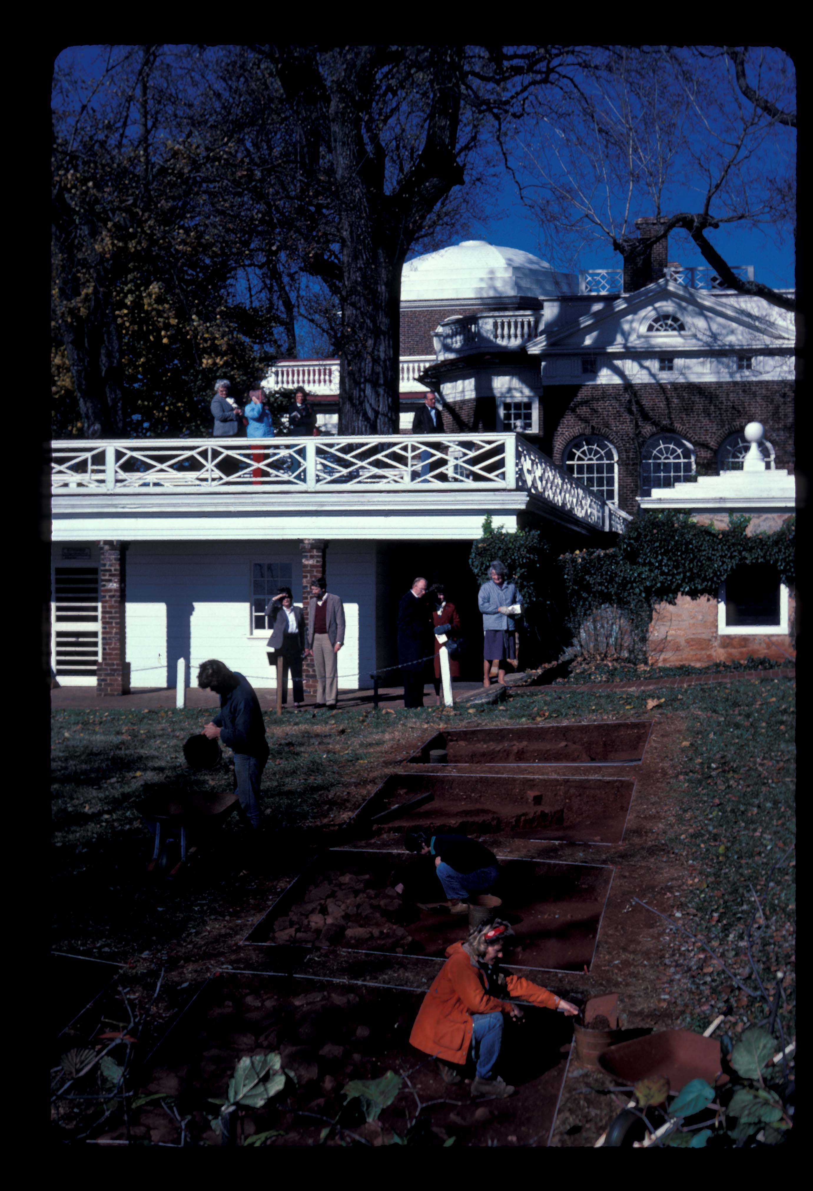
Overview of East Kitchen Yard excavations, c.1985, with Monticello Mansion in the background.
After completing excavation, Kelso stated in one report that identifying the original Jefferson landscape of the East Kitchen Yard proved “elusive except that…all during the nineteenth century great quantities of trash were thrown indiscriminately into that yard” (Kelso 1997: 44). While he identified “occasional postholes and planting holes” that suggested “yard use and appearance,” he did not believe they were evidence for formal landscaping during Jefferson’s life (ibid). In addition, Kelso stated that the “entire area except the driveway [the stone paving, Feature 07] was deeply plowed” (ibid).
Kelso interpreted the north-south paving (F07) as a “stone sub-paving of a substantial walkway or driveway” (ibid). Wood found below the paving in one quadrat was interpreted as an original wooden surface of the walkway. Kelso’s artifact analysis provided an estimated construction date of 1785 for this feature (ibid).
Kern
In 1993 Kern’s excavations in the East Kitchen Yard area were part of the Monticello-UVA Summer Field School (Kern 1993). Kern hoped to discover evidence of Jefferson-period deposits and landscaping, analyze ceramics and other artifacts for clues about the lives of those living in the South Dependency Wing and activities conducted there, and identify evidence of other Jefferson-period features relating to the re-organization of that area when the South Dependency Wing was constructed in 1809 (Kern 1993).
Furthermore, Kern identified several deposits as Jefferson-period re-deposited subsoil, likely generated from leveling the kitchen yard. The majority of this suspected yard fill was left unexcavated, as during her excavations Kern did not reach subsoil in all quadrats.
Hill
As part of the initial Mulberry Row Reassessment Project, Martha Hill conducted extensive research of both historical documents and previous archaeological research pertaining to the East Kitchen Yard area. Her work provides a valuable discussion of the history of the kitchen yard area, including changes to landscape configuration during Jefferson’s lifetime (Hill 2003). In particular, Hill provided a detailed interpretation of how the East Kitchen Yard was altered and leveled during the construction of the South Dependency wing and the All-Weather Passage under the mansion that began in 1801. Hill wrote:
“The excavations of the kitchen yard indicate that subsoil removed during construction of the south dependencies and tunnel was spread over the yard. This layer is quite deep near the arcade and diminishes as it descends the slope towards Mulberry Row; it covers the entirety of the yard” (ibid).
Kern discovered evidence of this massive earth-moving venture, as discussed above, while excavating immediately adjacent to the South Dependency wing.
Hill also identified three postholes (Features 09, 26, and 28) to the east of the paving (Feature 07) that were “probably contemporaneous with the paving ” (ibid). Hill found no pattern to the postholes to the west but agreed with Kelso that they may have “seated fencing or light constructions, such as coops” (ibid).
Mulberry Row Reassessment
Recent analysis of the East Kitchen Yard excavations support Kelso’s interpretation of the north-south paving (F07) as a walkway between the mansion and Mulberry Row. However, there is no evidence that the wood identified by Kelso as the original wood surface of the walkway is definitively an earlier portion of that feature. The archaeological evidence for the dates for construction, use, and abandonment of this walkway remain elusive.
The function of the many postholes and small features in the East Kitchen Yard remains unclear; however, Hill’s suggestion that they represent small temporary structures such as coops, or perhaps animal pens, seems likely. Given the proximity of the kitchen and building on Kelso’s interpretation that this was not a formalized area, it seems reasonable to interpret this as a work yard that serviced the South Dependencies, kitchen, and house during Jefferson’s life.
Furthermore, the deposits in this yard probably contain refuse from both the main house and the dependency wings. The ceramic assemblage contained sherds from forms used for both dining and household needs including plates, platters, teawares, and chamberpots. In addition to household ceramics, several utilitarian and food storage vessel fragments were identified during cataloging. This suggests that waste from the nearby kitchen in the South Dependency wing was deposited in the East Kitchen Yard. This is supported by the cataloguing of several other kitchen artifacts, including thirteen cast iron pot or pan fragments.
Unfortunately, two of the three postholes (F09 and F28) to the east of the north-south paving that Hill referenced contain no diagnostic artifacts; however, the third posthole (F26) contains creamware and pearlware sherds, indicating a Jefferson-period construction date.
In addition, this area contains copious reminders that the mountain was occupied by more people than the Jefferson family. Plowscars throughout the site likely coincide with episodes of plowing during post-Jefferson occupation or possibly Jeffersonian leveling, just like the West Kitchen Yard. Some of the small features may also represent nineteenth and early twentieth century intrusions. Repeated cuts by modern utility trenches are a permanent reminder of the ongoing impact to, and alteration of, the mountaintop landscape.
Elizabeth Sawyer
Monticello Department of Archaeology
July 2012
Things you need to know about the East Kitchen Yard before you use the data:
- The entire site was carefully hand-troweled and screens were not used for artifact recovery.
- Measurements are in feet and tenths of feet.
- Most of the Kelso excavations were conducted using the “Wheeler Box” excavation system of 8-by-8 foot quadrats with 2-foot baulks.
- Quadrats are in a variety of sizes, including 2-by-2 feet, 2-by-8 feet, 2.5-by-6 feet, 8-by-8 feet, and 10-by-8 feet.
- Although excavators recorded opening and closing elevations for most quadrats, these measurements are not always related to a known, fixed datum point. Therefore, context elevations were not entered into the database.
- All faunal remains were analyzed externally by the Colonial Williamsburg Department of Archaeology.
- Excavation of many contexts and quadrats from both the Kelso and Kern excavations were stopped arbitrarily prior to encountering and identifying sterile subsoil.
- In the DAACS database, the East Kitchen Yard project is designated as Project “110”. Artifact ID numbers for artifacts associated with the project therefore begin with the 110 prefix.
Feature Numbers
The original excavators of the East Kitchen Yard site did not assign numbers to individual features. DAACS staff assigned feature numbers using the original excavation records. Feature numbers assigned by DAACS have an F-prefix, which precedes the number (i.e. F01 equals Feature 1).
Excavated contexts that belong to the same depositional basin (e.g. a posthole and postmold or the layers in a single pit) have been assigned a single feature number. In addition, single contexts have been given feature numbers when the original field records indicate that the excavators recognized a context’s spatial distinctiveness from surrounding contexts.
Feature Groups
Feature groups are sets of features whose spatial arrangements indicate they were part of a single structure (e.g. structural postholes, subfloor pits, and hearth) or landscape element (e.g. postholes that comprise a fenceline). Feature Groups assigned by DAACS have a FG-prefix, which precedes the number (i.e. FG01 equals Feature Group 1).
| Feature | Feature Type | Contexts |
|---|---|---|
| F01 | Posthole | 1795B |
| F02 | Trench, utility | 1795C, 1800C, 1796B, 1797B, 1798B, 1799B |
| F03 | Trench, utility | 1001A, 1002A, 1009A, 1046D, 1044C, 1052C |
| F04 | Trench, utility | 1795F, 1007D, 1007F, 1795T |
| F05 | Trench, utility | 1795G, 1799E, 1798G, 1797C, 1796E, 1800F, 1795S |
| F06 | Trench, utility | 1004D, 1008E, 1009D, 1044E, 1052E, 207A |
| F07 | Walkway | 207B, 1001E, 1044N |
| F08 | Trench, builder’s | 1795J, 1798E, 1799H, 1797F, 1796H, 1800G, 1797H, 1795K, 1795L, 1795N |
| F09 | Posthole | 1004F |
| F10 | Posthole | 1001G |
| F11 | Trench, utility | 1001H, 1007C, 1042B, 1043C, 1005E |
| F12 | Trench, utility | 1001K |
| F13 | Trench, utility | 1001J |
| F14 | Posthole | 1799C |
| F15 | Posthole | 1798C |
| F16 | Brick in Course | 1798D, 1799J |
| F17 | Posthole | 1007G |
| F18 | Posthole, possible | 1007H |
| F19 | Posthole | 1800D |
| F20 | Unidentified | 1001N |
| F21 | Trench, utility | 1799F |
| F22 | Trench, utility | 1797E, 1796J, 1041C, 1044F, 1006D |
| F23 | Unidentified | 1800J |
| F24 | Trench, utility | 1002E |
| F25 | Trench, utility | 1045D, 1009J, 1042E, 1044J, 489C, 1052G |
| F26 | Posthole | 1002F, 1002G |
| F27 | Posthole, possible | 1799Q |
| F28 | Posthole | 1003E |
| F29 | Posthole, possible | 1798N |
| F30 | Posthole | 1041E |
| F31 | Trench, utility | 1009C, 1044D, 1042C, 1046C, 1051B, 1052D |
| F32 | Trench, utility | 1042F |
| F33 | Posthole | 1009G |
| F34 | Planting Hole | 1043G, 1043H |
| F35 | Unidentified | 1429C |
| F36 | Posthole | 1005G |
| F37 | Walkway | 1429E |
| F38 | Posthole | 1005F |
| F39 | Not a Basin/Cut | 1006C |
| F40 | Planting Hole | 1006F |
| F41 | Unidentified | 1006H |
| F42 | Posthole | 1006G |
| F43 | Posthole, possible | 1006J |
| F44 | Trench, utility | 494C, 505C |
| F45 | Trench, utility | 1796N |
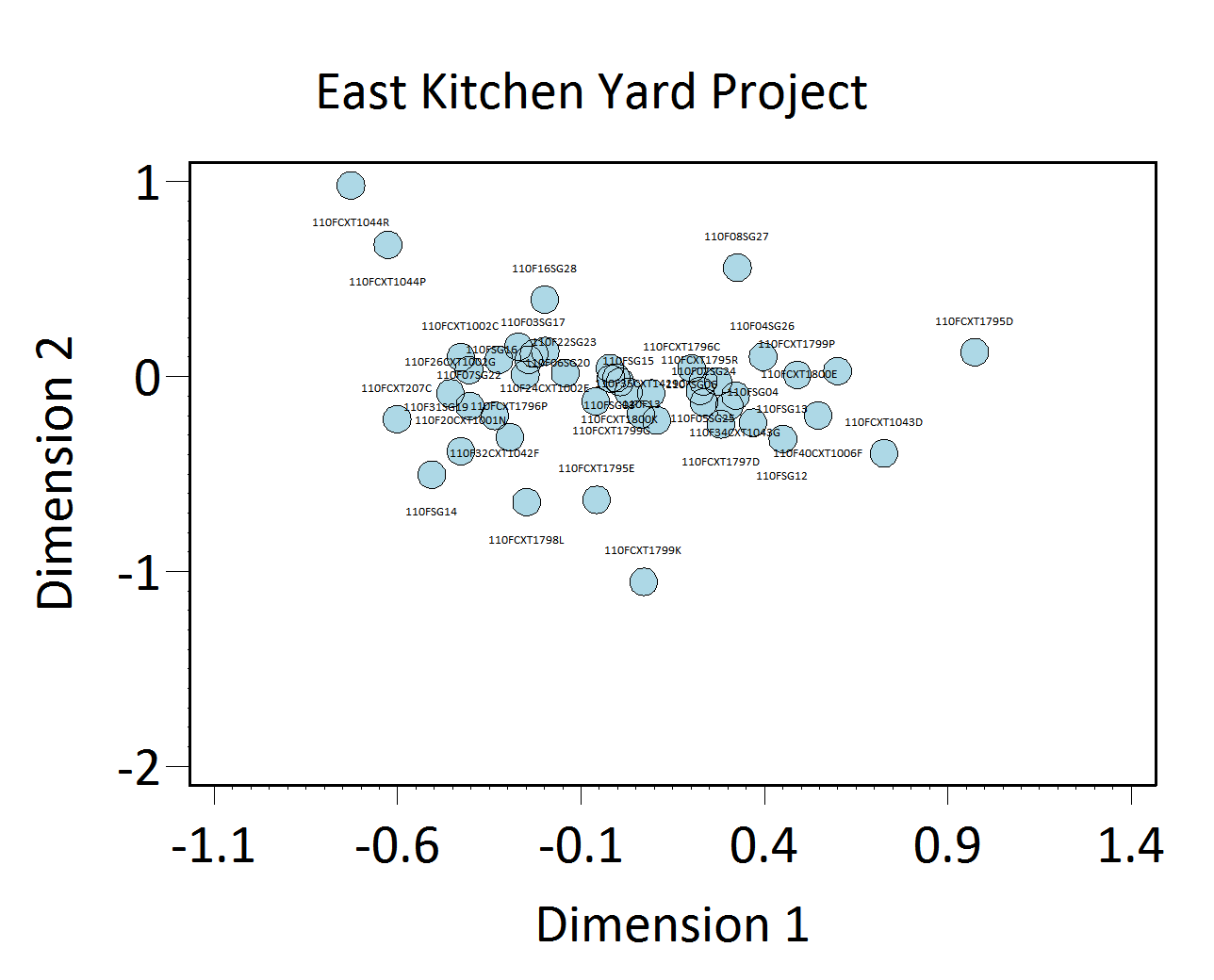
Figure 1. Plot of contexts along CA Dimensions 1 and 2. Time runs from left to right.
Intra-Site Chronologies
We perform a standard set of analyses to infer intra-site chronologies for the sites included in the Archive. Using them, we have assigned most excavated contexts at each site to a set of site-specific phases. The use of common analytical methods is designed to increase comparability among phases at different sites. The methods and the phase assignments they produced are summarized below. For some sites, the original excavators developed intra-site chronologies and, where these exist, they are included on the Background page for the site. DAACS encourages users of Archive data to help explore improvements.
DAACS Seriation Method
This page summarizes the frequency-seriation-based chronology we developed for the East Kitchen Yard site (see Neiman, Galle, and Wheeler 2003 for technical details).
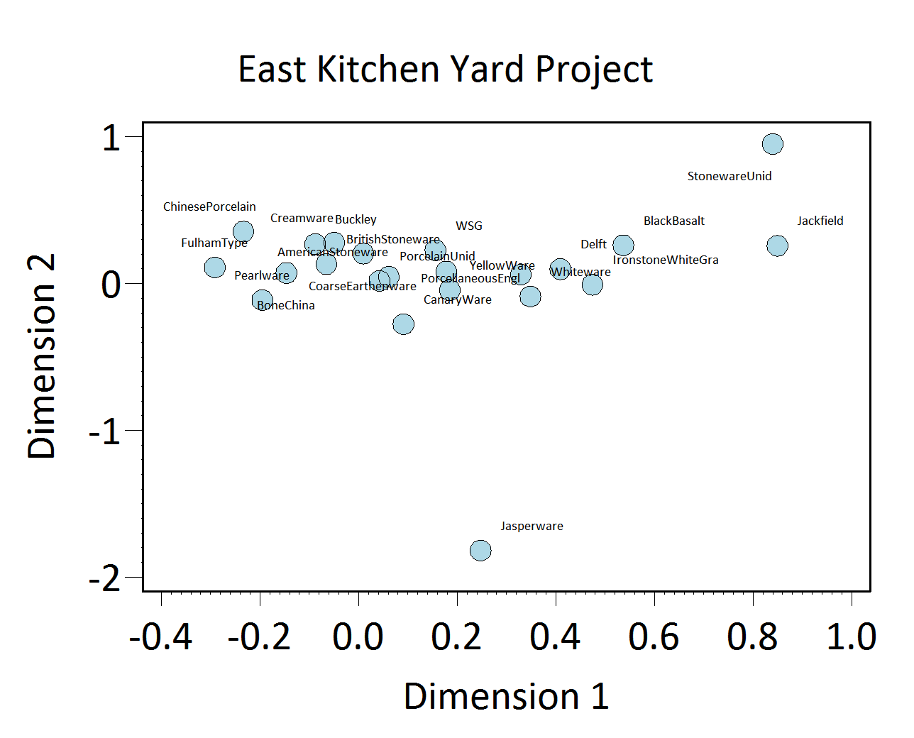
Figure 2. Plot of MCD Types along CA Dimensions 1 and 2. Note that later types are on the right.
As with other sites in the Archive, the seriation chronology for the East Kitchen Yard was derived from ceramic assemblages aggregated at the level of contexts and stratigraphic groups, and not at the level of features. This is because most contexts and stratigraphic groups on the site were not parts of features. For the relatively few cases where seriated contexts and stratigraphic groups were parts of features, the relevant feature numbers and descriptions are included in the seriation chronology table below. The seriation chronology is the result of a correspondence analysis of ware-type frequencies in each stratigraphic group and each individual context that had no stratigraphic group assignment (Figures 1 and 2). Not all contexts have stratigraphic group assignments.
To reduce the noise introduced by sampling error, only ceramic assemblages with more than 5 sherds and more than one ceramic type from individual excavated contexts and from stratigraphic groups were included. SG01 and SG11, two topsoil SGs, and SG05 (a plowzone deposit) were removed from the seriation in an iterative process due to unusually high contributions of these SGs to inertia. Redware and refined stoneware, unidentified were removed for the same reason. The subsequent results produced a strong correlation between Dimension 1 scores and MCDs (Figure 3). Based on the dips in ceramic counts observed in a histogram of Dimension 1, we divided the East Kitchen Yard site into three phases (Figure 4).
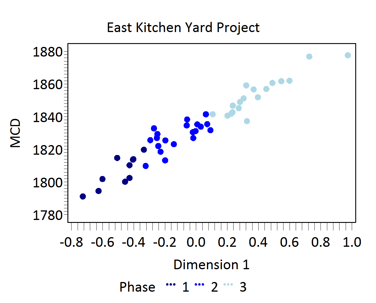
Figure 3. CA Dimension 1 scores plotted against Mean Ceramic Dates.
East Kitchen Yard Phases
Phases are groups of assemblages that have similar correspondence-analysis scores, similar MCDs, or both, and are therefore inferred to be broadly contemporary. Phases have a P-prefix that precedes the phase number (e.g. P01 equals Phase 1).
Mean ceramic dates for the site-specific phases are given in the table below. The table also includes two estimates of the ceramic TPQ for each phase. The first TPQ estimate is the usual one – the maximum beginning manufacturing date among all the MCD types in the assemblage. The second estimate — TPQp90 — is the 90th percentile of the beginning manufacturing dates among all the sherds in the assemblage, based on their MCD-types. This TPQ estimate is more robust against excavation errors and taphonomic processes that might have introduced a few anomalously late sherds in an assemblage.
| Phase | MCD | TPQ | TPQp90 | Total Count |
|---|---|---|---|---|
| P01 | 1812 | 1840 | 1820 | 1229 |
| P02 | 1830 | 1840 | 1820 | 6215 |
| P03 | 1846 | 1840 | 1820 | 2890 |
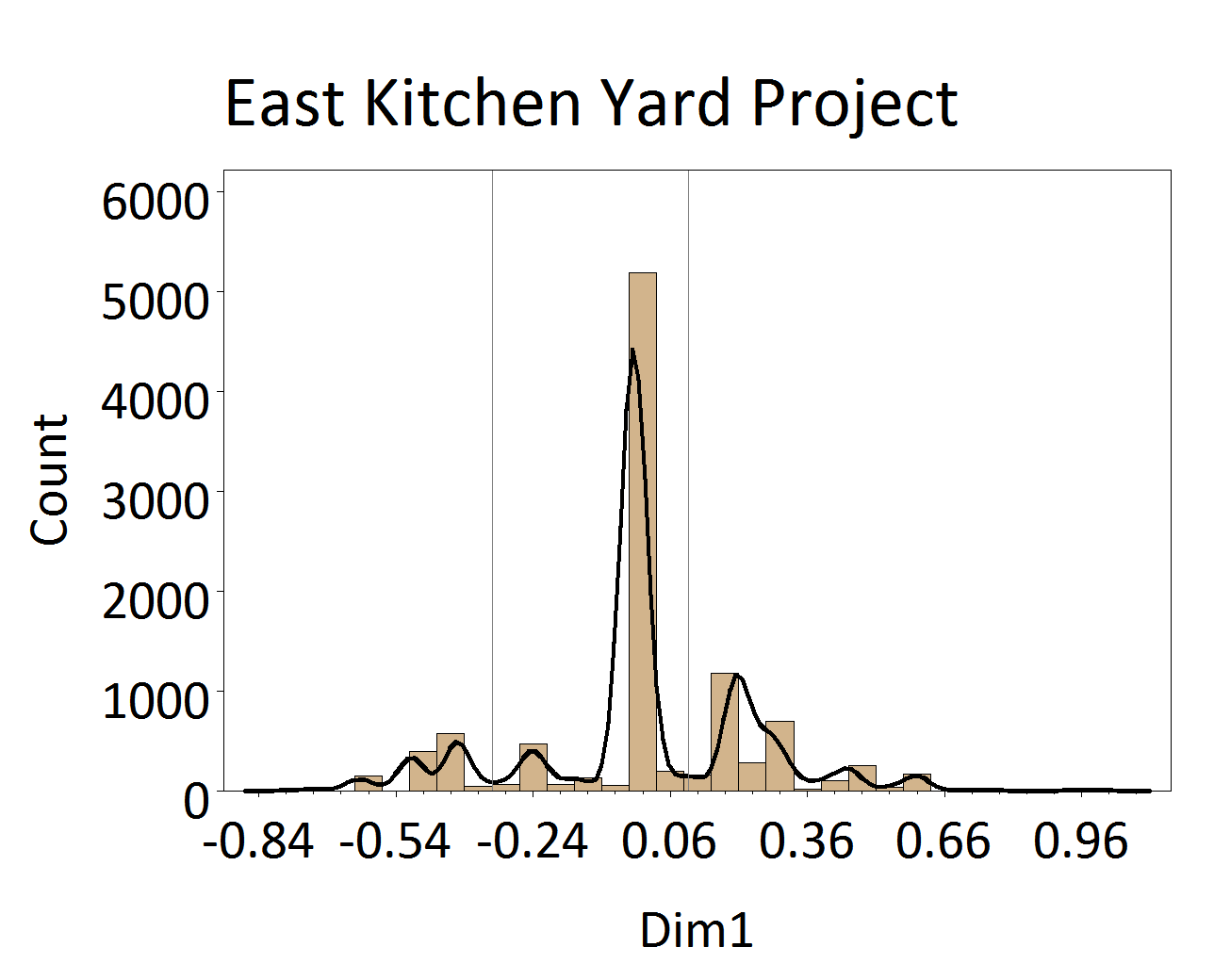
Figure 4. Histogram of ceramics from the Project plotted along CA Dimension 1. The lines indicate DAACS phase divisions.
Phase one is comprised of a handful of contexts and SGs that date to Monticello II. The stone paving (SG22) associated with a kitchen path that ran from the covered passageway to Mulberry Row was placed in this phase. Phase two and three assemblages have progressively more post-Jefferson material. Phase three assemblages, in particular, highlight the ongoing use of the area for decades following the sale of Monticello.
A Seriation Chronology for the East Kitchen Yard
The following table presents a seriation chronology for the East Kitchen Yard. We use the indefinite article to signify that it is not the only chronology possible, nor the best. We encourage users of Archive data to help explore improvements.
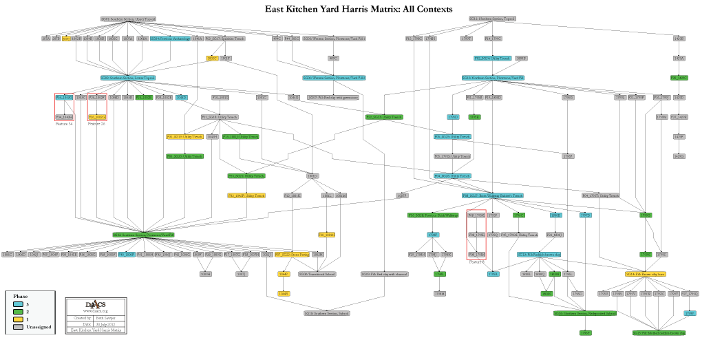
The stratigraphic relationships among stratigraphic groups and unassigned contexts are summarized in the Harris Matrix for the site. Phase assignments from the seriation are shown on the Harris Matrix in color, facilitating comparison of the seriation chronology and the stratigraphic chronology of the site.
East Kitchen Yard Harris Matrix
The Harris Matrix summarizes stratigraphic relationships among excavated contexts and groups of contexts that DAACS staff has identified as part of the same stratigraphic group. Stratigraphic groups and contexts are represented as boxes, while lines connecting them represent temporal relationships implied by the site’s stratification, as recorded by the site’s excavators (Harris 1979).
Stratigraphic groups, which represent multiple contexts, are identified on the diagram by their numeric designations (e.g. SG10) followed by the original excavator’s descriptions of them (e.g. “Fill: Reddish-brown clay”). Contexts that could not be assigned to stratigraphic groups are identified by their individual context numbers (e.g. 1795A). Features consisting of multiple contexts and/or stratigraphic groups are outlined with red boxes.
Boxes with color fill represent contexts and stratigraphic groups with ceramic assemblages large enough to be included in the DAACS seriation of the site (see Chronology Page). Their seriation-based phase assignments are denoted by different colors to facilitate evaluation of the agreement between the stratigraphic and seriation chronologies. Grey boxes represent contexts that were not included in the seriation.
Due to the large number of utility trenches that intrude this site, two Harris Matrices are provided: one including all contexts for the site and one excluding utility trenches. Furthermore, the matrix without utility lines is divided into two excavation campaigns because without the inclusion of the utility trenches, there are no deposits to unite these two sets of quadrats.
See East Kitchen Yard Site Chronology for detailed stratigraphic and phase information. Please note that some of the contexts present in the chronology analysis are not visualized on the Harris Matrix. The contexts that are not included do not have any stratigraphic relationships with other contexts. The lack of relationships can occur for a few reasons but two common examples are 1) the artifacts are from a surface collection, which is entered into DAACS as a context but does not have recorded relationships to other contexts that are below it; 2) in cases where topsoil and plowzone are stripped and discarded, there may be features below the plowzone that are comprised of a single context. Since the plowzone does not exist as a documented context with artifacts, it cannot seal the single-context feature. DAACS also does not record subsoil as a context, so there is nothing for that single context feature to intrude or seal.
This Harris Matrix is based on data on stratigraphic relationships recorded among contexts in the DAACS database. It was drawn with the ArchEd application. See http://www.ads.tuwien.ac.at/arched/index.html.
For a printable version, download the Harris Matrix [225.53 KB PDF].

PDF of composite excavator’s plan, compiled by Monticello staff from original field drawings, with excavation units and features labeled.
PDF of composite excavator's plan, compiled by Monticello staff from original field drawings, with only excavation units labeled.
PDF of composite excavator’s plan, compiled by Monticello staff from original field drawings, with only features labeled.
Harris, Edward C.
1979 Principles of Archaeological Stratigraphy. Academic Press, London, England.
Jefferson, Thomas
1776a Monticello: outbuildings and garden (study), circa 1776-1778. N87; K56. Thomas Jefferson Papers: An Electronic Archive. Massachusetts Historical Society, Boston, MA. http://www.thomasjeffersonpapers.org
Jefferson, Thomas
1809b Monticello: mountaintop (plat). N225; K169. Thomas Jefferson Papers: An Electronic Archive. Massachusetts Historical Society, Boston, MA. http://www.thomasjeffersonpapers.org
Jefferson, Thomas
1806b Monticello: survey notes, page 2 of 3. N203.2; K167i . Thomas Jefferson Papers: An Electronic Archive. Massachusetts Historical Society, Boston, MA. http://www.thomasjeffersonpapers.org
Jefferson, Thomas
1806c Monticello: surveyed land (plat). N204; K167j. Thomas Jefferson Papers: An Electronic Archive. Massachusetts Historical Society, Boston, MA. http://www.thomasjeffersonpapers.org
Kelso, William M.
1997 Archaeology at Monticello: Artifacts of Everyday Life in the Plantation Community. Monticello Monograph Series. Thomas Jefferson Foundation, Charlottesville, Virginia.
Kern, Susan
1993 Research Notes: Kitchen. South Wing Research. Unpublished document on file at the Monticello Department of Archaeology, Charlottesville, Virginia.
Leepson, Marc
2001 Saving Monticello: The Levy Family. The Free Press: New York, New York.
Neiman, Fraser D., Jillian E. Galle , and Derek Wheeler
2003 Chronological Inference and DAACS. Unpublished paper presented at the annual meeting of the Society for Historical Archaeology, Providence, Rhode Island. On file at the Department of Archaeology, Thomas Jefferson Foundation, Charlottesville, Virginia.