
| Location: | Governor's Land, Governor's Land, VA, United States |
|---|---|
| Occupation Dates: | Last quarter 17th/first quarter 18th century. Phasing and mean ceramic dates can be found on the Chronology page. |
| Excavator(s): | Dr. Garrett Fesler. |
| Dates excavated: | 1992. |
Overview
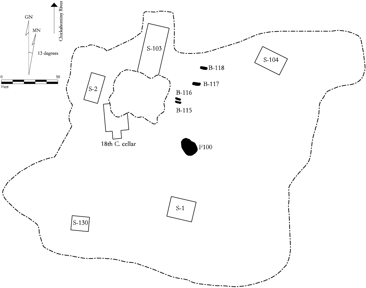
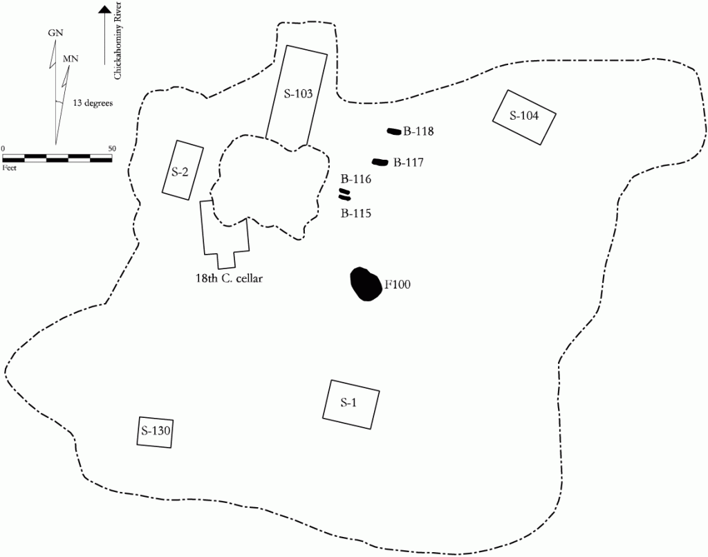
Site map of 44JC298
Archaeological site 44JC298 contains evidence of historic habitation ranging from a Virginia Company-period settlement, dating to the early seventeenth century (ca. 1619 – 1622), to a prosperous family farm that was active as recently as the 1950s. Several archaeological excavations have taken place at site 44JC298, each focusing on a specific occupation phase. The Quarter Dwelling (S-104) is just one component at 44JC298, consisting of a single 16 ft. by 26 ft. post-in-ground structure with more than a dozen sub-floor pits that dates to the late seventeenth and early eighteenth centuries.
Archaeologists, affiliated with the James River Institute for Archaeology, Inc. (JRIA), excavated the Quarter Dwelling at 44JC298 in April and May 1992. The site is located in the Governor’s Land at Two Rivers, a 1,440 acre planned residential and recreational community situated a few miles west of the City of Williamsburg near the confluence of the James and Chickahominy rivers. Site 44JC298, including the Quarter Dwelling, is situated on the crest of a terraced bluff nearly forty feet above sea level, and has a commanding view of the mouth of the Chickahominy River some 1,000 ft. to the west. Given its ideal location, it is not surprising that at least five discrete periods of historic occupation have been documented at site 44JC298.
Background History

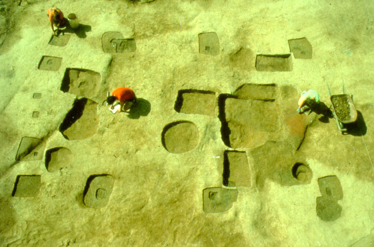
44JC298, Structure 104 during excavation.
Initial historic settlement began at site 44JC298 in late 1619, when a group of fifty indentured servants under the command of Lieutenant Jabez Whittaker took up residence on the property. The previous year, the leaders of the Virginia Company of London, the joint stock company of adventurers and investors intent upon making the new colonizing effort profitable, divided the fledgling colony into four boroughs. Within each borough, 3,000 acre tracts were set aside as “Company Land” for the use of Virginia Company officials. Site 44JC298 is located on the western edge of what was once the Company Land parcel within the borough of James City. Hired to establish and oversee its Company Land parcel in James City, by 1621, Whittaker reported that he had more than 100 men working the land and his plantation functioned as a “guest house” where newly arriving servants could begin the process of “seasoning,” or acclimating to the harsh Virginia climate (McCartney 1991). The Company Land venture was abandoned in 1622 when a coordinated attack by the local Powhatan Indians forced most of the survivors to retreat to Jamestown.
Activity began anew at 44JC298 in the 1630s when Captain Bridges Freeman patented several thousand acres, including much of the former Company Land tract. Freeman may have been one of the servants living at 44JC298 a decade earlier (McCartney 1991). Captain Freeman took up residence at 44JC298, building at least a dwelling house for himself and his family. Archaeological evidence indicates his house had a tile roof. Freeman was dead by 1663 and his son and namesake inherited the property. The younger Freeman probably chose to live elsewhere on the vast estate, but operated a ferry service across the mouth of the Chickahominy River within sight of 44JC298 until the early eighteenth century (McCartney 1991). The Quarter Dwelling was built at 44JC298 under Bridges Freeman II’s watch, probably in the 1670s or perhaps as late as the 1680s.
There is very little existing documentary information pertaining to Freeman II, and almost nothing concerning the Quarter Dwelling at 44JC298. Determining the identity of the inhabitants of the Quarter Dwelling must be based almost entirely on conjecture and inference. For example, the date of occupancy (ca. 1670 to ca. 1710) appears to correspond with Bridges Freeman II. It is possible that Freeman built the Quarter Dwelling at 44JC298 to house slaves working at the ferry. The site probably also functioned as an agricultural quarter for field slaves working the property. Activity at the Quarter Dwelling seems to have ceased around the time when Freeman II disappears from the documentary record in the first decade of the eighteenth century.
Additional buildings were erected at the site in the mid-eighteenth century and the site continued to serve as an agricultural quarter into the early nineteenth century. In the final two decades of the eighteenth century, the property was owned by planter Champion Travis and later by the Francis Whittle family. Much of the property was repeatedly logged beginning in the late nineteenth century and into the twentieth. Eventually in the early twentieth century, 44JC298 was reoccupied again, this time by the Paul Greisenaur family and later the Hoffmeyer family. By the mid-twentieth century, the site was abandoned for the final time.
Archaeological Background

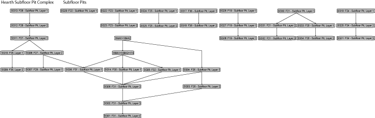
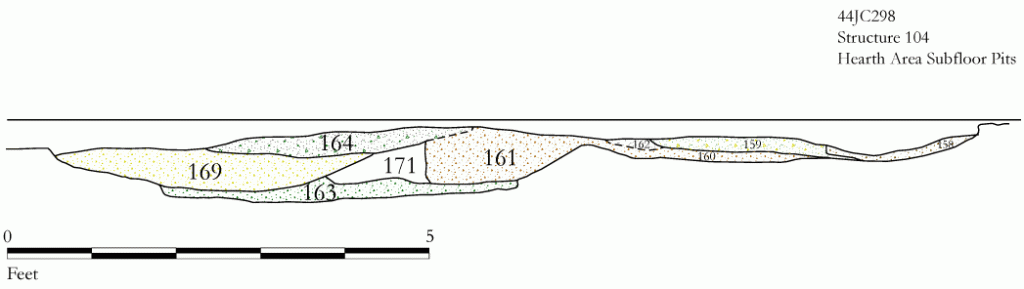
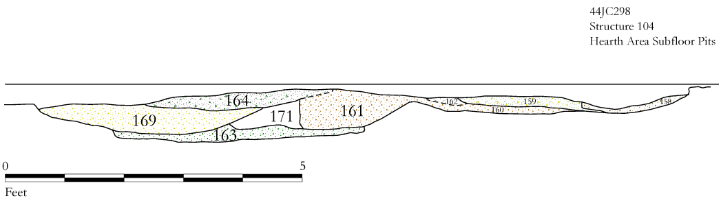
Profile drawing of Structure 104 subfloor pits near hearth.
Site 44JC298 was first identified in the early 1980s when the College of William and Mary’s Department of Anthropology conducted a preliminary archaeological survey of the tract (Sprinkle 1984). Artifacts dating to the seventeenth, eighteenth, and nineteenth centuries were recovered at that time from the site. Subsequently, William and Mary conducted Phase II testing at 44JC298 during the summer seasons in 1984 and 1985 with the use of field school students. A large oval pit feature was located along with four other smaller features. Eventually the pit was interpreted as a late 18th-/early 19th-century cellar. All other features dated from the same period except for a large undefined soil stain which went untested, but may have dated to the seventeenth century (Reinhart 1984).
In 1990, JRIA conducted a Phase III archaeological salvage excavation on a portion of the site in advance of the construction of a golf course fairway. The fairway was due to cut through an area of the site containing primarily early seventeenth-century features. The salvage operation first consisted of mechanically stripping off the plowzone from the threatened area. Among the many features that were exposed, the posthole patterns or foundations of a total of seven structures were uncovered, as well as six major trash pits, four human burials, a large backfilled seventeenth-century well, and other sundry features. The Quarter Dwelling was one of seven structures uncovered in 1990 during plowzone removal, however, it was located on the periphery of the proposed golf course fairway and golf course planners shifted the fairway design to avoid it. Archaeologists assigned context number 104 to the Quarter Dwelling, mapped it in plan, and placed a layer of filter fabric and a sheet of thick, black polyethylene plastic over the Quarter.
In 1992, plans for the fairway changed and designers discovered that it needed to be expanded. The proposed expansion of the fairway encroached on the Quarter Dwelling. In April and May 1992, JRIA excavated the Quarter Dwelling and all associated features that were threatened by the fairway expansion.
Excavation Methods
Once the topsoil and plowzone were removed from overtop the site, archaeologists used flat shovels and trowels to further expose and define the Quarter Dwelling. It subsequently was mapped in plan at a ¼”=1’ scale. Each feature was assigned a context number. Trowels were used to excavate the features and all soil was sifted through ¼” hardware cloth. All features were bisected at least once and a profile and plan was drawn at an 1”=1’ scale. Some of the more complex sub-floor pits were bisected several times. A minimum of five liters of soil was collected from each sub-floor pit and processed through a soil flotation system. Heavy and light fraction materials were sorted by hand with the aid of a magnifying glass and incorporated into the artifact collection from the site.
Archaeological Findings
The Quarter Dwelling was 16 ft. wide and 26 ft. in length, set on ten main structural posts. Two of its bays were set at 10 ft. intervals, and the easternmost bay appears to have been a 6 ft. by 16 ft. shed addition. Several of the main postholes were repaired.
The west end bay was 10 ft. by 16 ft. in size and contained an area of scorched clay in the center of the gable end that betrays the location of a hearth. Based on the position of the scorched area inside the gable wall, the chimney may have been an interior smoke hood. Due to the lack of brick, the chimney almost certainly was a wattled and daubed clay affair. A large complex of sub-floor pits fronted the hearth. Preliminary analysis suggests that at least five discrete episodes of cutting and refilling occurred in this complex. Two additional sub-floor pits were located in the western bay, abutting up against the north and south walls. One, Sub-Floor Pit (SFP) 157, had evidence of wood lining along its walls. The floor of the other, SFP 150, had been heavily scorched.
The center bay contained two sub-floor pits, both located near the center axis of the structure. Only a thin shelf of undisturbed subsoil separated rectangular SFP 151 from the complex of pits immediately to the east. SFP 152 was located only a short distance north from SFP 151, and was circular in shape.
The shed addition extended 6 ft. off the east end of the main house. Four main structural posts were used to hold up the addition, as well as several post studs. Entrance into the shed probably occurred through a 3 ft. wide door located between Postholes 104H/J and 104K/L. Three sub-floor pits, and perhaps a fourth one cut by later pits, were located inside the shed.
A post-and-rail fence may have connected to the southwest corner of the building and extended to the west. A second fence may have extended off the northwest corner of the building to the north.
To the best of our knowledge, the Quarter Dwelling stood in isolation at the site. Roughly half of site 44JC298 has been excavated, and within those areas, the archaeological resources either predate or postdate the Quarter. It is possible that contemporaneous buildings and features are present at site 44JC298 that relate to the Quarter Dwelling. However, if they exist, they remain protected in a wooded easement north of the golf fairway, the only threat of damage to the site from errant golf shots.
Garrett Fesler
James River Institute for Archaeology (JRIA)
December 2003
Things you need to know about 44JC298 before you use the data:
- Measurements are in feet and tenths of feet.
Feature Numbers
The original excavators of 44JC298 did not assign numbers to individual features. DAACS staff has assigned feature numbers using the original excavation records. Feature Numbers assigned by DAACS have a F-prefix, which precedes the number (i.e. F01 equals Feature 1).
Excavated contexts that belong to the same depositional basin (e.g. a posthole and postmold or the layers in a single pit) have been assigned a single feature number. In addition, single contexts have been given feature numbers when the original field records indicate that the excavators recognized a context’s spatial distinctiveness from surrounding contexts.
Feature Groups
Feature groups are sets of features whose spatial arrangements indicate they were part of a single structure (e.g. structural postholes, subfloor pits, and hearth) or landscape element (e.g. postholes that comprise a fenceline). Feature Groups assigned by DAACS have a FG-prefix, which precedes the number (i.e. FG01 equals Feature Group 1).
| Feature | Feature Type | Contexts |
|---|---|---|
| F01 | Posthole | 104A, 104B, 104AL |
| F02 | Posthole | 104C, 104D |
| F03 | Posthole | 104E, 104F, 104F1 |
| F04 | Posthole | 104G, 104AM |
| F05 | Posthole | 104H, 104J |
| F06 | Posthole | 104K, 104L |
| F07 | Posthole | 104AH |
| F08 | Posthole | 104AJ |
| F09 | Posthole | 104N, 104M, 104N1 |
| F10 | Posthole | 104P, 104R, 104R1, 104P/R, 104R2 |
| F11 | Posthole | 104S, 104T |
| F12 | Posthole | 104X, 104W |
| F13 | Posthole | 104Y, 104Z, 104AA, 104BB |
| F14 | Posthole | 104AE, 104AF |
| F15 | Posthole | 104AG |
| F16 | Posthole | 104AC |
| F17 | Posthole | 104AN, 104AD |
| F18 | Posthole | 104AK |
| F19 | Pit, subfloor(< 28 sq.ft) | 153B2, 153A1, 153B1, 153C1 |
| F20 | Pit, subfloor(< 28 sq.ft) | 156B, 156A |
| F21 | Pit, subfloor(< 28 sq.ft) | 155A1, 155A2, 155B1, 155C, 155B2 |
| F22 | Pit, subfloor(< 28 sq.ft) | 154A1, 154A2, 154A3 |
| F23 | Pit, subfloor(< 28 sq.ft) | 151A1, 151B1, 151A2, 151A3 |
| F24 | Pit, subfloor(< 28 sq.ft) | 152, 152A1, 152A2, 152A3, 152A4, 152B1, 152C1 |
| F25 | Pit, subfloor(< 28 sq.ft) | 150A1, 150A2, 150B1 |
| F26 | Pit, subfloor(< 28 sq.ft) | 161B1, 161A, 170A1, 161A1, 161A2, 161A3, 161A4, 170A2 |
| F27 | Pit, subfloor(< 28 sq.ft) | 159A, 159A1, 159A2, 162A1 |
| F28 | Pit, subfloor(< 28 sq.ft) | 158A, 158A1, 158A2, 158B1 |
| F29 | Pit, subfloor(< 28 sq.ft) | 160A1 |
| F30 | Pit, subfloor(< 28 sq.ft) | 169A2, 169A3 |
| F31 | Pit, subfloor(< 28 sq.ft) | 163A, 171A1, 163A1, 163A2, 163A3, 163B1, 172A1, 172A3, 172A2 |
| F32 | Pit, subfloor(< 28 sq.ft) | 175 |
| F33 | Pit, subfloor(< 28 sq.ft) | 166 |
| F34 | Burned Subsoil | 167 |
| F35 | Pit, subfloor(< 28 sq.ft) | 173B1, 173A1, 173B2 |
| F36 | Pit, subfloor(< 28 sq.ft) | 157B1, 157A1, 157A2, 157A3 |
| F37 | Posthole | 184A, 184B |
| F38 | Posthole | 182A, 182B |
| F39 | Posthole | 183A, 183B |
| F40 | Posthole | 181A, 181B |
| F41 | Posthole | 185 |
| F42 | Posthole | 186A, 186B |
| F43 | Posthole | 187A, 187B |
44JC298 Chronology
Because none of the features at JC298 contained more than five ceramic sherds, DAACS was unable to produce a seriation-based chronology for the site (see Neiman, Galle, and Wheeler 2003 for technical details). However, the site-wide TPQ and TPQp90 values of 1700 point to the occupation’s temporal placement in the late-seventeenth and very early-eighteenth century. The Mean Ceramic Date of 1751 is a misleading artifact of the wide date ranges, spanning the late-seventeenth through early-nineteenth centuries for the ceramic types that dominate the small assemblage (e.g. Colono, Redware, and Delft).
| Unit | MCD | TPQ | TPQp90 | Total Count |
|---|---|---|---|---|
| Site | 1751 | 1700 | 1700 | 29 |
The stratigraphic relationships among stratigraphic groups and unassigned contexts are summarized in the Harris Matrix for the site.
44JC298 Harris Matrix
The Harris Matrix summarizes stratigraphic relationships among excavated contexts and groups of contexts that DAACS staff has identified as part of the same stratigraphic group. Stratigraphic groups and contexts are represented as boxes, while lines connecting them represent temporal relationships implied by the site’s stratification, as recorded by the site’s excavators (Harris 1979).
Stratigraphic groups, which represent multiple contexts, are identified on the diagram by their numeric designations (e.g. SG02) followed by descriptions of them (e.g. “Subfloor Pit 6, Layer 3”). Contexts that could not be assigned to stratigraphic groups are identified by their individual context numbers (e.g. 164A1).
Boxes with color fill represent contexts and stratigraphic groups with ceramic assemblages large enough to be included in the DAACS seriation of the site (see Chronology). Their seriation-based phase assignments are denoted by different colors to facilitate evaluation of the agreement between the stratigraphic and seriation chronologies. Grey boxes represent contexts that were not included in the seriation because of small ceramic samples.
This Harris Matrix is based on data on stratigraphic relationships recorded among contexts in the DAACS database. It was drawn with the ArchEd application. See http://www.ads.tuwien.ac.at/arched/index.html.
For a printable version, download the Harris Matrix [46.07 KB PDF].

PDF of composite excavator's plan compiled by DAACS from original field drawings.
CAD site plan in .dgn format.
Harris, Edward C.
1979 Principles of Archaeological Stratigraphy. Academic Press, London, England.
McCartney, Martha
1991 History of the Governor’s Land at Two Rivers, James City County, Virginia. On file, James River Institute for Archaeology, Inc. Williamsburg, Virginia.
Neiman, Fraser D., Jillian E. Galle , and Derek Wheeler
2003 Chronological Inference and DAACS. Unpublished paper presented at the annual meeting of the Society for Historical Archaeology, Providence, Rhode Island. On file at the Department of Archaeology, Thomas Jefferson Foundation, Charlottesville, Virginia.
Reinhart, Theodore
1984 Unpaginated manuscript of 1984 field results at site 44JC298. On file at the Anthropology Department, the College of William and Mary, Williamsburg, Virginia.
Sprinkle, John H., Jr.
1984 An Archaeological Survey of “The Governor’s Land”, James City County, Virginia. Unpublished MA thesis, Department of Anthropology, College of William and Mary, Williamsburg, Virginia.