| Location: | The Hermitage Plantation, Hermitage, Tennessee |
|---|---|
| Occupation Dates: | c. 1820 through c. 1870 |
| Excavator(s): | Samuel Smith Division of Archaeology, Tennessee Department of Conservation (1974, 1974), Daniel Brock, Ladies Hermitage Association (2004-2006) |
| Dates excavated: | 1974, 1975, 2004, 2005, 2006 |
Overview
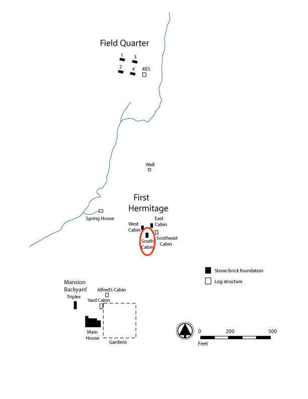
Figure 1: Plantation map the South Cabin, located at the First Hermitage, highlighted.
The South Cabin, a 20-by-40-foot brick duplex residence, was constructed around 1821 in area of The Hermitage plantation known today as the First Hermitage (Figure 1). The First Hermitage represents the original core of the Hermitage property, where two log buildings served as the Jackson family home (West Cabin) and detached kitchen and dwelling for enslaved laborers (East Cabin) from the time of their purchase of the property in 1804 until the completion of the brick mansion in 1821. A third structure (Southeast Cabin), likely a log structure identified archaeologically by a limestone hearth, stood to the southeast of, and was likely contemporaneous with, the West and East Cabins.
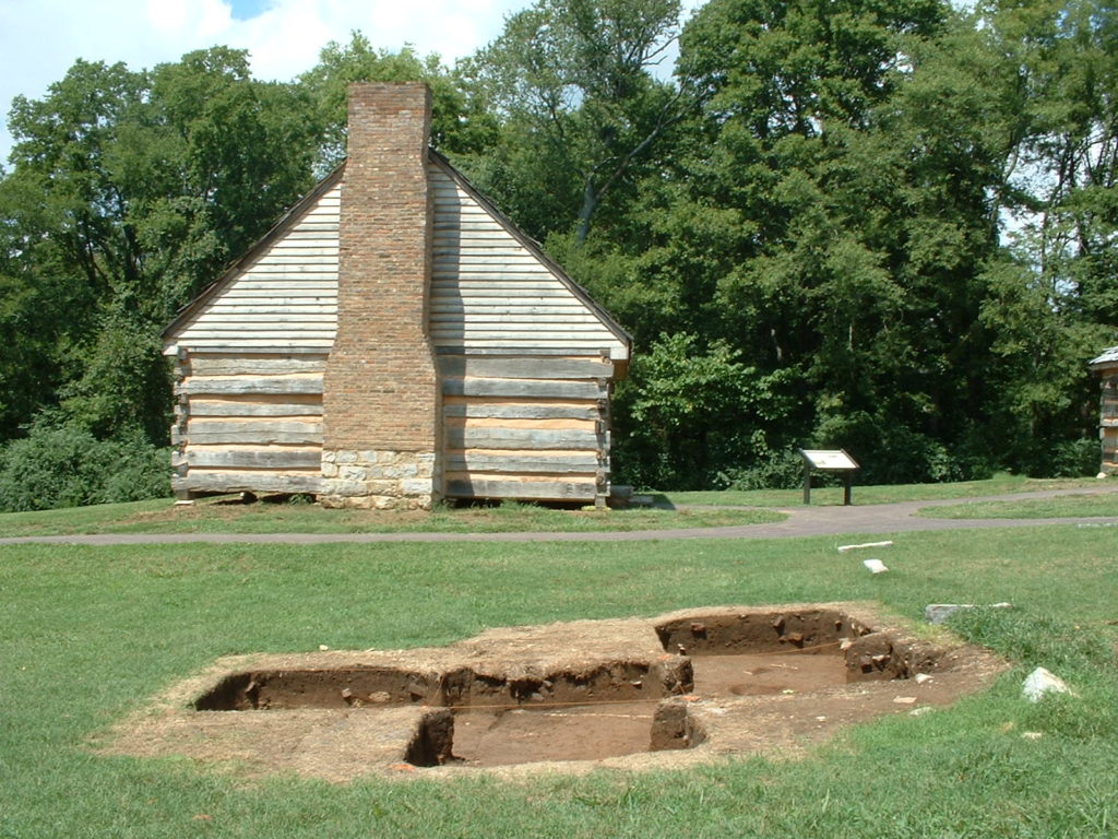
The site of the South Cabin is located approximately 25 feet south of, and equidistance between, the East and West Cabins (Figure 2). Its presence was first identified during surface survey by Samuel Smith, who hypothesizes that two chimney falls with a depressed area between them was suggestive of a two-unit, or duplex. Subsequent excavation revealed a stone and brick foundation measuring 20.5-by-40-feet, with a limestone foundation partition wall dividing it in half. Exterior postholes located at the southern end of the cabin indicated a possible structural addition or porch. A subfloor pit measuring 3.8-by-4.2- feet was excavated in the southwest portion of the cabin’s interior and a second subfloor pit was identified but not fully excavated.
Archaeological research confirms that the Southeast Cabin was constructed from bricks produced during a major building campaign that results in the construction of the mansion, the Triplex, and four additional 20-by-40-foot duplexes at the Field Quarter. The architecture, along with artifact assemblages, indicates the building was constructed in the early 1820s and was dismantled in the early 1870s. Once the Jacksons moved into their brick mansion in 1821, the First Hermitage became a quarter area for enslaved African American families, where it continued to serve as housing for between 6-7 enslaved families until Emancipation.
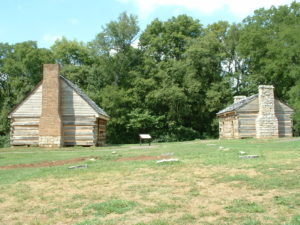
Figure 2: Looking toward the extant West (left) and East (right) Cabins, from south of the South Cabin. The stone “piers” on the grass were placed by the museum to demarcate the boundaries of the building. Facing north. Photograph taken between 2004-2006.
Archaeological excavations were led by Samuel Smith in 1974 and 1975. Daniel Brock oversaw excavations at the Southeast Cabin during the summers of 2004, 2005, and 2006. In 2007, Kevin Bartoy, in collaboration with DAACS, received an IMLS grant to establish a DAACS Satellite Lab at The Hermitage. In 2008, Bartoy and his team received a National Endowment for the Humanities grant for the analysis of three Hermitage Sites, including the South Cabin. This grant was subsequently transferred to DAACS at Monticello.
Documentary Evidence
No historical documentation exists for the South Cabin and few primary documents provide descriptions of the First Hermitage area during the early nineteenth century. The land that became The Hermitage was acquired as a land grant in the early 1780s by Nathaniel Hays. Dendrochronology indicates that the two-story farmhouse, later the one-story West Cabin, was constructed between 1798 and 1800. Hays lived there with his wife, two children, and two enslaved people until he sold the property to Andrew Jackson on August 23, 1804 (Smith 1976).
Documentary evidence suggests that Hays allowed Jackson to begin improvements on the property before the deed of sale, and that he had hired laborers to clear the land, make fences, construct the East Cabin, and redecorate the West Cabin (Smith 1975). Smith surmises that the Jackson family were likely living at The First Hermitage by October 1804, but most certainly by February 1805 (ibid. 33). An estimated twelve enslaved people were laboring at The Hermitage by 1804, some of whom likely lived in the East and Southeast Cabins. By the time Jackson moved into the mansion in 1821, forty-four enslaved people were listed as living at The Hermitage. By 1850, Jackson enslaved 137 people (Thomas 1995:34).
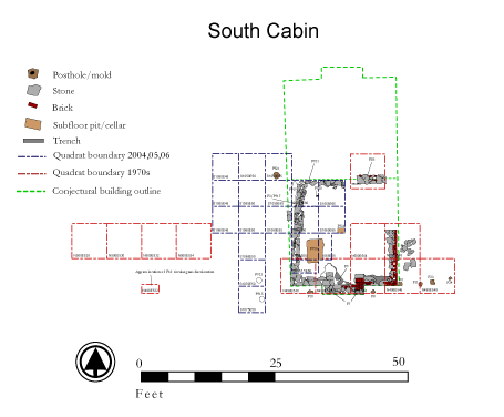
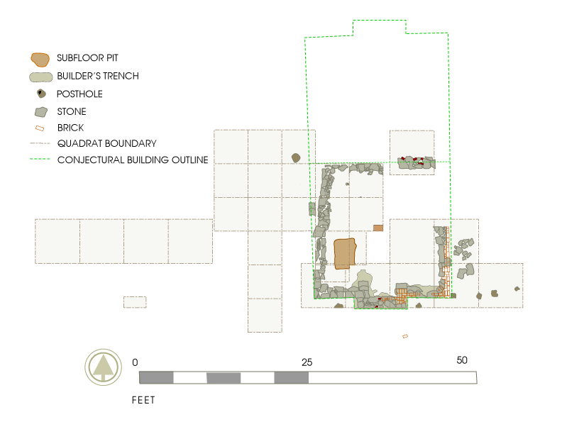
Figure 3: South Cabin site map.
Excavation history, procedure, and methods
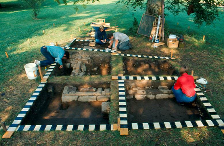
The First Hermitage is one of the most extensively explored areas, archaeologically, at The Hermitage. Archaeological research led by Samiel Smith (1970s), Jane Hinshaw (early 1980s), Larry Mckee (1987-1999), and Elizabeth Kellar (2000-2003).
1974 and 1975 excavation seasons
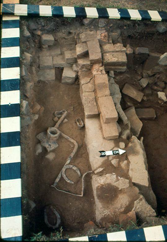
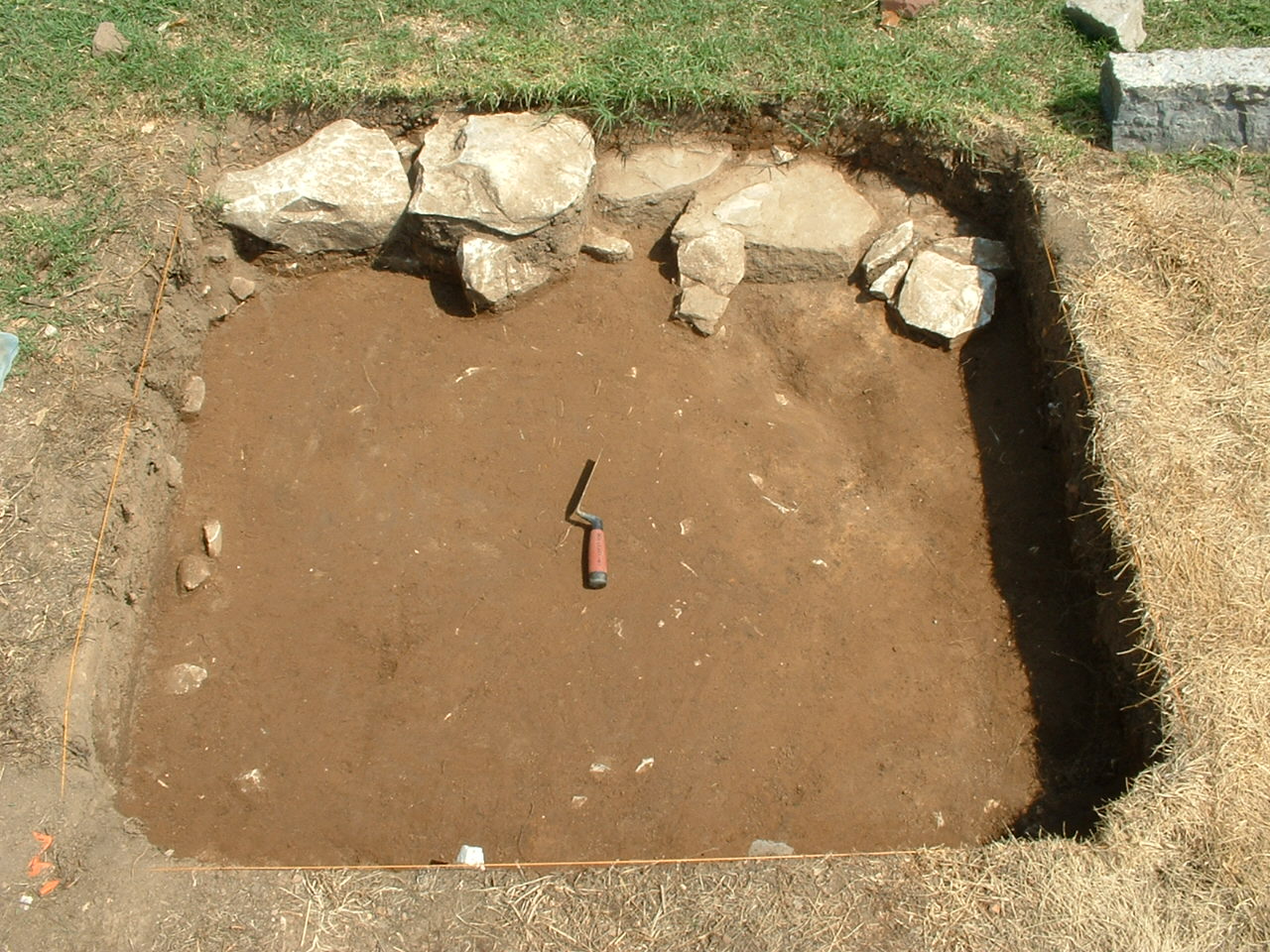
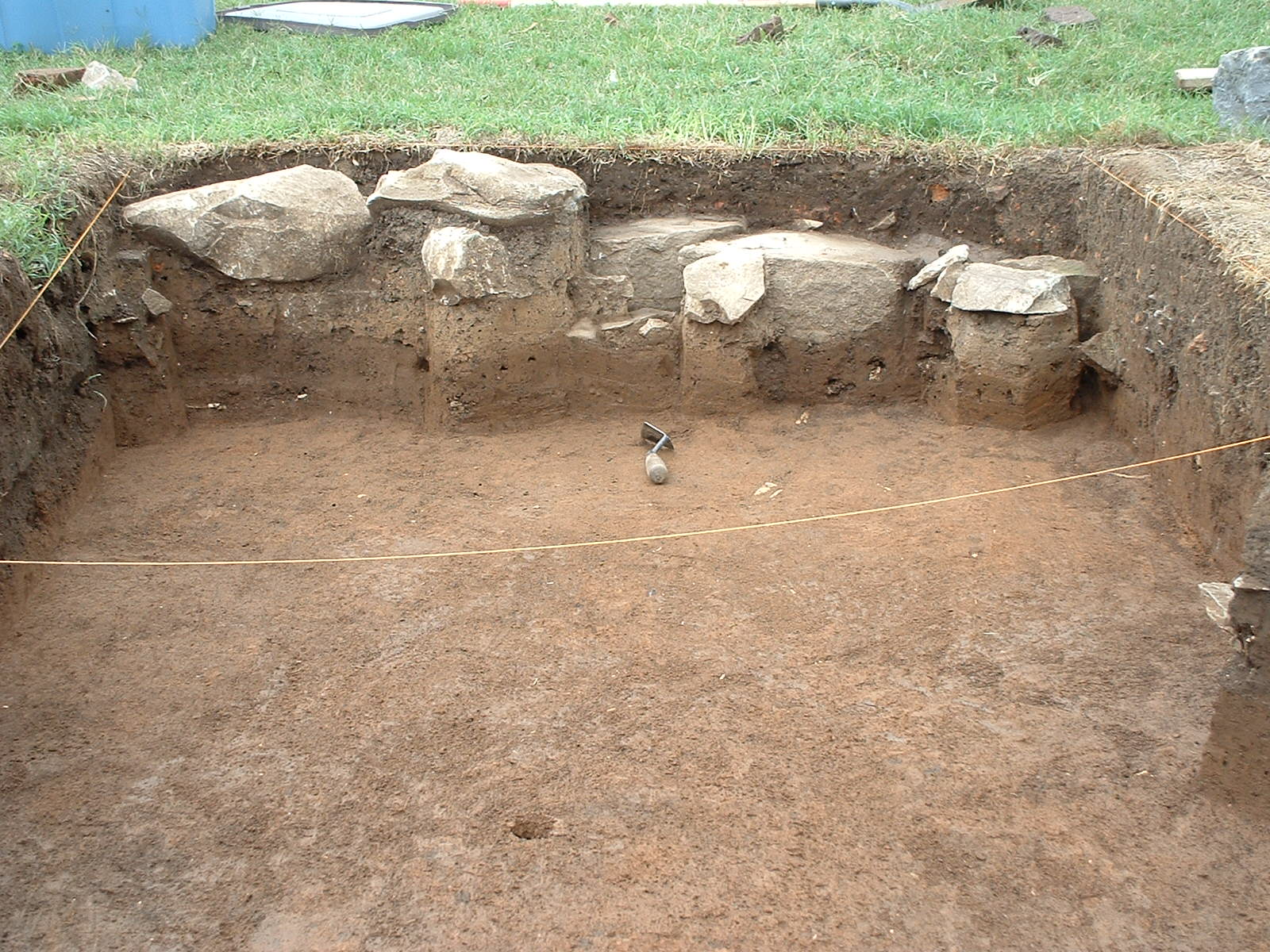
The first major archaeological campaign at The Hermitage began in early 1974, when the Division of Archaeology with the Tennessee Department of Conservation surveyed the property and developed a proposal of archaeological research for key areas of the plantation. With approval of, and in collaboration with the Ladies Hermitage Association, Dr. Samuel Smith, the Division of Archaeology’s Historical Archaeology, initiated archaeological fieldwork at the First Hermitage in late July 1974. He chose the South Cabin as the focus of field work, in part because surface evidence of two limestone chimneys with a depression between the two indicated the remains of a building that, unlike the West and East Cabin, was no longer standing on the site.

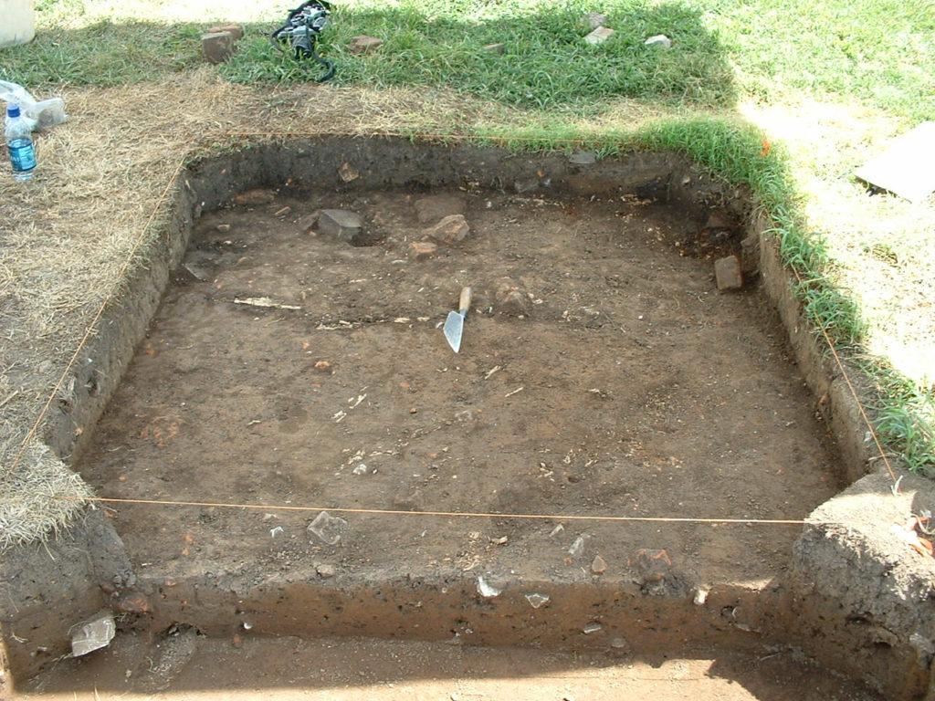
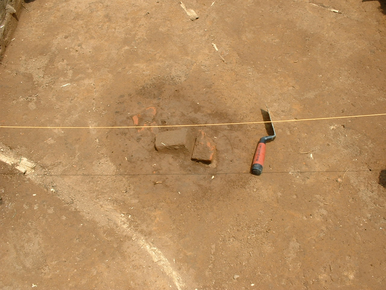
Figure 4: View of South Cabin south chimney during 1970s excavations. Facing west.
Smith established a permanent grid across the property (details are in Smiths 1976 field report), establishing a standard 2-x-2-meter quadrat size. The 1974 field season focused on exposing the southern foundation wall, with Smith placing six 2-by-2-meter units east-west along the limestone wall (Figure 4). During the 1975 season, a 2-x-2-meter quadrat, was placed to expose the limestone foundation that partitioned the building into two units, and several units were placed outside the building’s southeast corner in order to investigate a possible structure addition, as well as to the west, to investigate a circular grass discoloration.
Smith and his team excavated a total of twelve 2-x-2 meter-units and one 1-x-2-meter unit during their two field seasons (Figure 5). All quadrats were excavated by natural stratigraphic levels and screened through ¼ inch mesh. The following strata were observed:
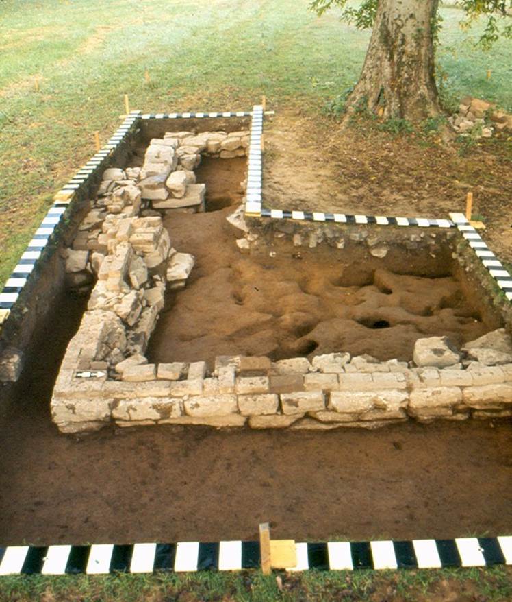
Figure 5: View of South Cabin south chimney during 1970s excavations. Facing west.
Zone I averaged between 10 and 20 cm of dark humic soil overlying the structural remains of the South Cabin and containing much brick and rubble from the south chimney fall of the cabin. This zone was interpreted as humic buildup occurring after the building ceased to exist.
Zone 2 averaged 10cm of yellow/tan, somewhat clayey soil which tended to overlie and extend outward from the foundation. This zone was interpreted as a period in which the building was either in a state of abandonment or was being disassembled, or both.
Zone 3 varied in composition depending on horizontal location. Within the foundation, north and south of the partition, fill averaged between 20 and 30 cm of brown loamy fill. Outside the foundation, it averaged 20 cm of gray ashy soil with lenses of tan to yellowish ash, in some places the layering was quite complex. Zone 3 inside the foundation was interpreted as a “typical” under-the-floor type fill, rich in organic materials and artifacts. This layer was extensively disturbed by animals. Outside the foundation, Zone 3 was interpreted as representing a gradual buildup during the period of occupation, including fireplace ash dumping, as well as including possible under-the-floor fill in areas thought to be structural additions.
Fifteen features were recorded during the 1974 and 1975 seasons at the South Cabin. See the Before You Begin page to see how features designated in the 1970s are differentiated from later features designated at the South Cabin in DAACS. Smith’s subsurface archaeological excavations and surface survey revealed that the South Cabin was a duplex measuring 20.5-by40-feet. Later archaeological research by McKee at the four Field Quarter duplexes (Cabins 1-4) and the Triplex in the Mansion backyard, revealed that the South Cabin was of the same construction as these brick quarters: substantial cut-limestone foundation with brick walls constructed in 20-by-20-foot dwelling units, most often arrayed as duplexes with end chimneys. At the South Cabin, Smith’s discovery of several postholes aligned at the southeastern corner of the cabin’s exterior, suggest a possible structural addition to the South Cabin. Further testing to the east and south would be needed to substantiate this.
1996 First Hermitage Auger Survey
In 1996, auger testing around the First Hermitage was done with a 4-inch soil auger twisted into the ground by hand at regular intervals tied into the site grid system. The soil pulled out of the holes was then examined for distinctive qualities, such as ash and charcoal content, and screened in order to collect any artifacts which might be present. During this survey, excavators inserted the auger until they reached clearly undisturbed subsoil, usually between 1.5 and 2 feet on Hermitage property. The auger test survey extended over the South Cabin site but context and artifact data from this auger survey has not been entered into DAACS.
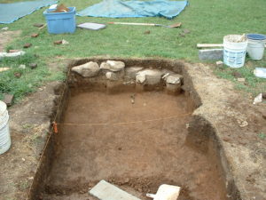
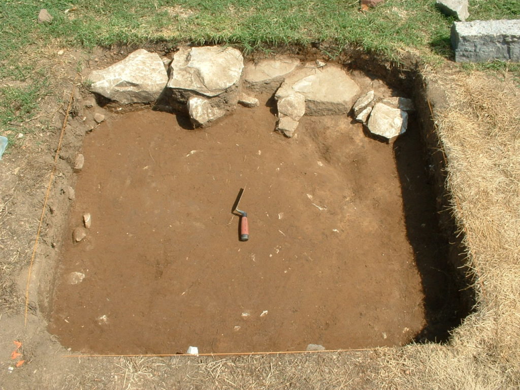
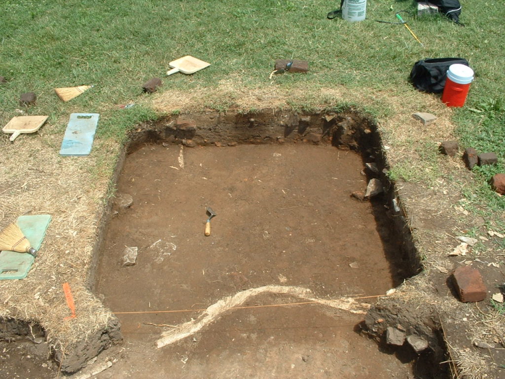
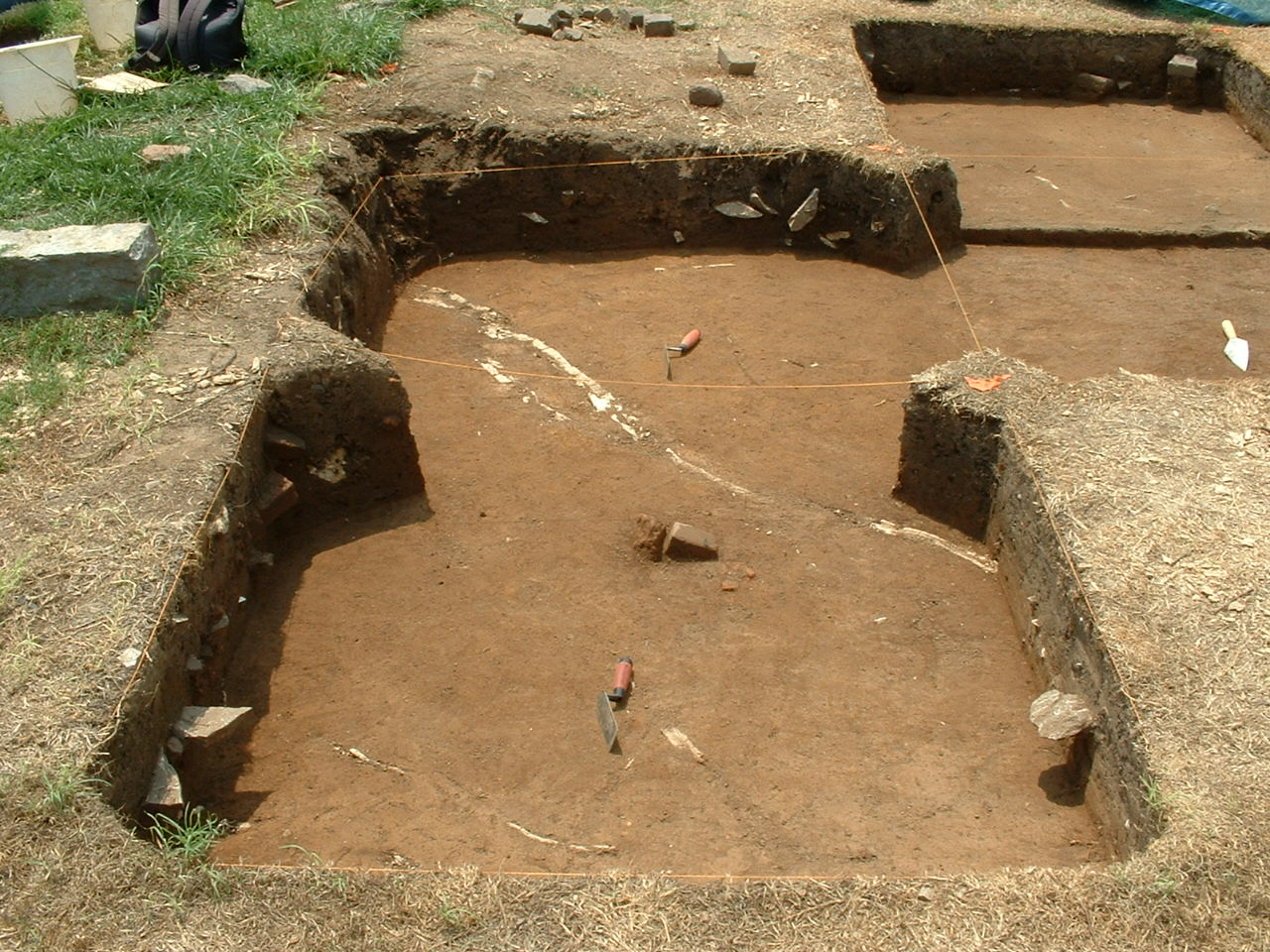
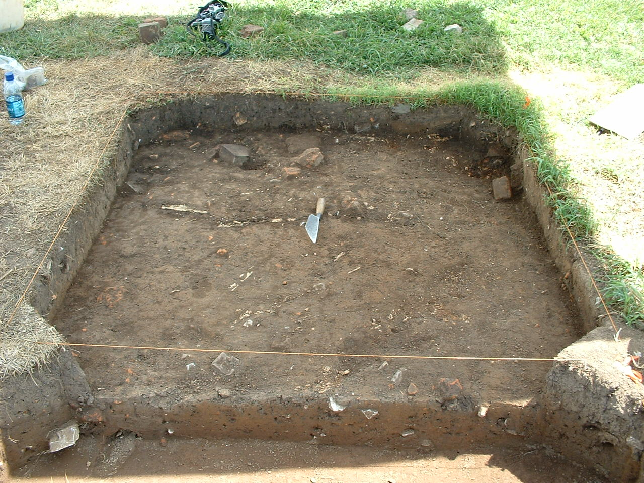
Figure 6: View of South Cabin partition foundation during 2006 excavations.
1997 First Hermitage Shovel-test Survey
In 1997, large-scale excavations were initiated at the First Hermitage under the direction of Ladies Hermitage Association Director of Archaeology, Larry McKee. Work in 1997 focused on the interior and exterior of the East Cabin, as well as including systematic shovel-test survey based on artifact densities gleaned from the 1996 auger test assemblages. A grid of 2.5-x-2.5-foot units was laid across the area and units were placed over auger locations with high artifact densities. One of these units was placed at the northwest corner of the South Cabin. Context and artifact data for this unit (project 97-04) has not yet been reanalyzed in DAACS.
Based on excavations elsewhere at The Hermitage under the direction of McKee (1987-1999), the following distinct strata were defined over much of the plantation landscape at The Hermitage, expanding on Smith’s work:
Level 1: Material deposited after the primary occupation of the site; the overburden and sod buildup.
Level 2A: Transitional area between recent and older deposits, mixed together by surface disturbance (plowing, tilling, rodent activity).
Level 2B: Layers related to the destruction and/or abandonment, including rubble scatters and fire/destruction layers. Structural features such as walls and hearth bases are likely to appear first in this layer.
Level 2C: Primary occupation layer. Deeper features such as postholes and root cellars definable at this level.
Level 2D: Deeper primary deposits earlier than and distinct from Level 2C (primary occupation layer) material.
Level 3: Culturally-sterile soil; subsoil.
2004, 2005, and 2006 South Cabin Excavations
Daniel Brock, then a doctoral student at the University of Tennessee, returned to the South Cabin in 2004. His 2004 excavation season focused on the southwestern portion of the building in order to confirm structural features and to identify potential activity areas. The broad strata identified during these seasons aligned with previous recording of strata at the Hermitage during McKee’s tenure; however, Brock conflated several levels and recorded only the following three distinct cultural strata at the South Cabin:
Level 1: Modern Level
Level 2 A/B: Destruction Level
Level 2 C/D: Occupation Level
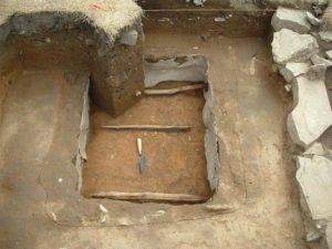
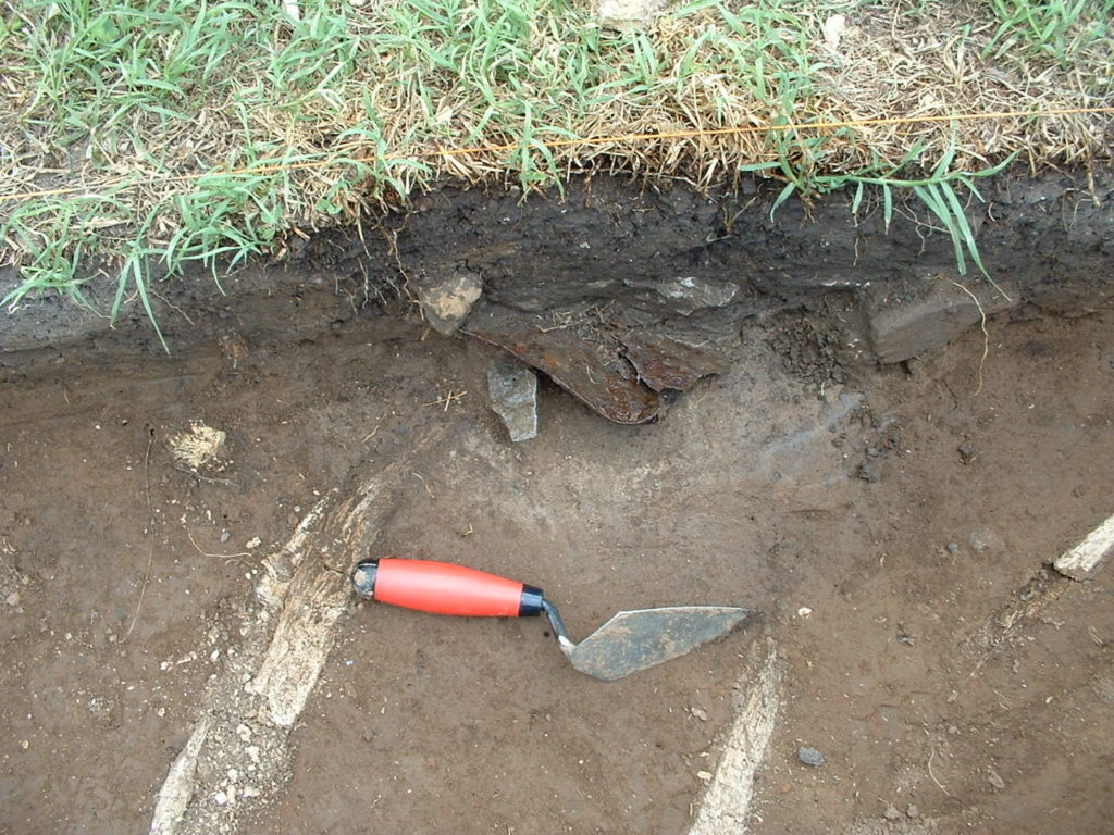
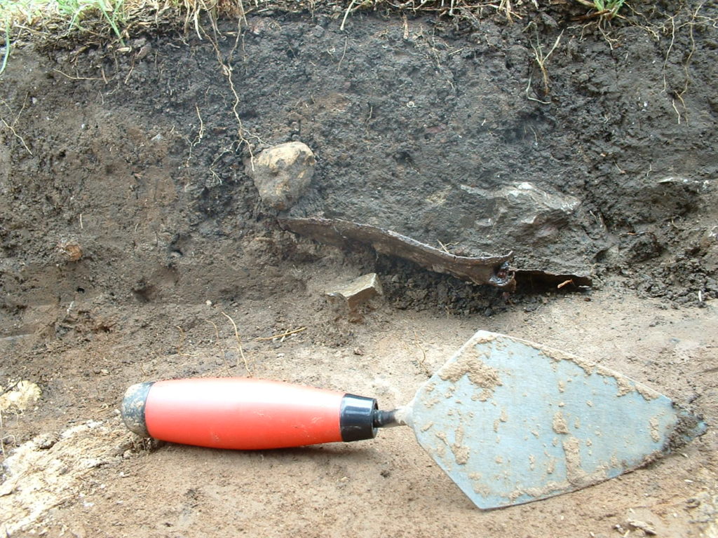
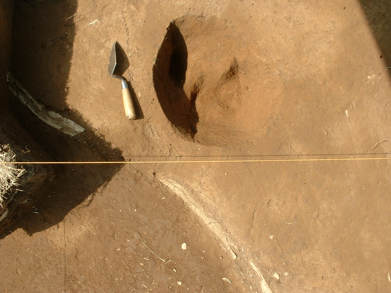
Figure 7: Feature 916, a lead-lined subfloor pit inside South Cabin, with wood dividers in situ, facing south.
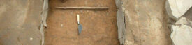
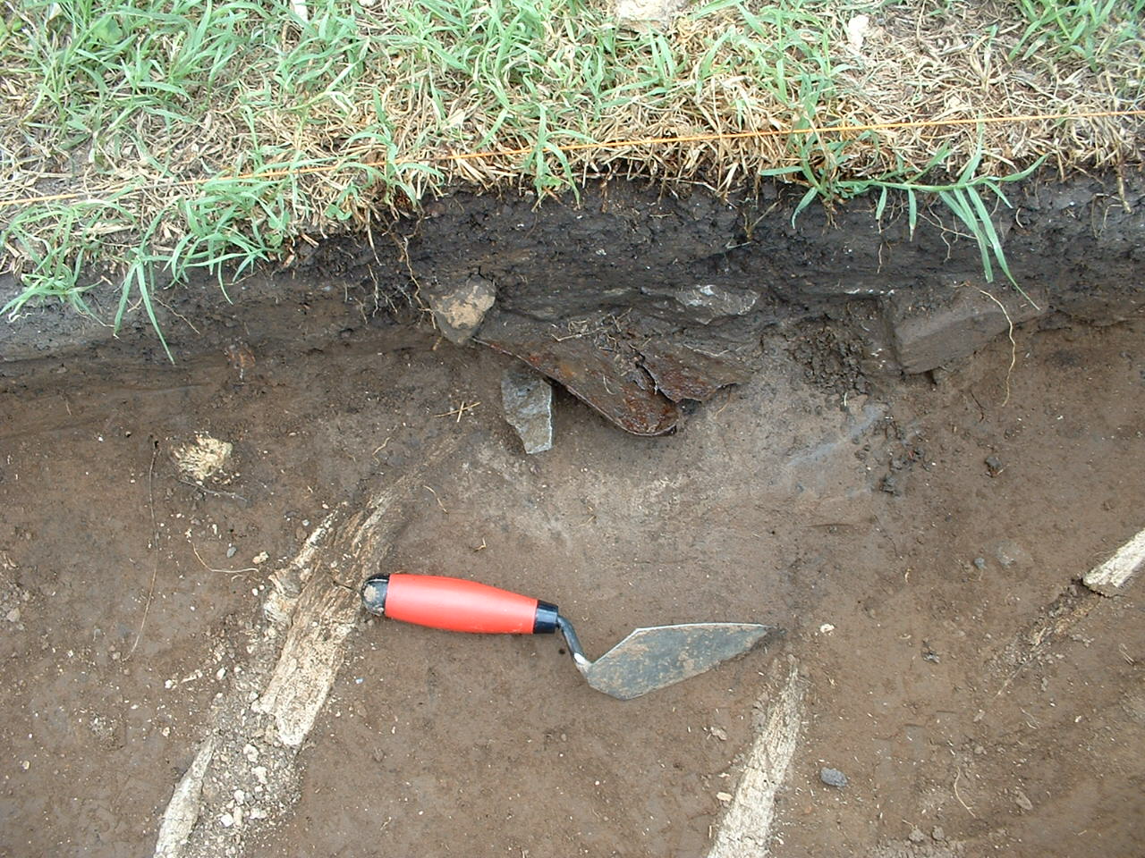
Between 2004 and 2006, Brock continued to focus on the southern half of the South Cabin, opening three- and one-half units along the western foundation wall, and two- and one-half units on the interior of the southern unit of the building (Figure 6). Excavations in the southwest of the cabin’s interior revealed a lead-lined subfloor pit (Feature 916) (Figure 7). Measuring 3.8-by-4.2-feet, this pit was the first lead-lined subfloor pit excavated at The Hermitage. While a relatively common architectural feature in Hermitage quarters, they are usually unlined or lined with brick. This pit not only had a lead lining but also remains of three cedar boards in situ at the bottom of the pit. Feature 916 was excavated in .5 ft arbitrary levels and notable artifacts included an 1841 dime, marbles, straight pins, and a pocketknife. The northwest corner of a second subfloor pit (Feature 931) located approximately three feet to the northeast of Feature 916 was excavated to subsoil but the remaining full of the subfloor pit cut below subsoil was not excavated.
Summary of research and analysis
Since 1974, scholars have written numerous site reports, articles and dissertations about archaeological research on enslavement at The Hermitage. Nearly all refer to the First Hermitage (Battle Baptiste 2004, 2010, 2011; Galle 1998, 2004; McKee 1995, 1997, 2000; Russell 1997; Thomas 1995, 1998, 2004; Smith 1976), and some of these specifically focus on the archaeological assemblages from the South Cabin (Galle 2004; McKee 1997; Thomas 1995, 1998; Smith 1976).
With the launch of the South Cabin data on the DAACS website, scholars now have access to all the field and artifact data from the site, which were not previously accessible. DAACS staff have begun working with the data, first in developing a standardized chronology for the South Cabin, the detailed results of which can be found on the site’s Chronology page (link). Ceramic correspondence analysis indicates that the South Cabin was occupied from the early 1820s through the 1870s, with two occupational phases, one with a BLUE Mean Ceramic Date (BLUEMCD) of 1818, the second phase with a BLUEMCD of 1855. BLUEMCDs give less influence to ceramic types with long manufacturing spans.
In 2006, then Director of Archaeology at The Hermitage, Kevin Bartoy, sought funding to catalog the Hermitage assemblages into DAACS. With first an Institute of Museum and Library Sciences grant, then with a National Endowment for the Humanities grant, Bartoy, in collaboration with DAACS, established a DAACS satellite lab at The Hermitage. Between 2007 and late 2008, Bartoy and his staff cataloged field contexts and artifacts from the Triplex, the South Cabin, and Cabin 2. In early 2009, the NEH grant funding was transferred from The Hermitage to the DAACS Lab at Monticello. This included moving the entire collection to the DAACS Lab at Monticello. DAACS staff completed cataloging and analysis of the Yard Cabin, the Triplex North, Middle, and South units, and Cabins 1, 2, 3, and 4 at the Field Quarter.
In 2014, DAACS (Jillian Galle, Principal Investigator) was awarded a second NEH grant Beyond the Mansion 2.0: Completing a Digital Archive for Thirty Years of Archaeological Research at The Hermitage (PW-51724-14). The grant’s goals included the identification, analysis and cataloging of all the contexts, maps, and artifacts from the four First Hermitage sites, the West Cabin, East Cabin, Southeast Cabin, South Cabin, and for extensive excavations in the yard areas between the buildings. During the project, DAACS staff rehoused, identified, analyzed and cataloged 231,883 non-zooarchaeological artifacts. They also analyzed and cataloged 1157 field records generated during the multiple seasons of excavations at The First Hermitage. 218 field records and 51,882 non-zooarchaeological artifacts were analyzed and cataloged from the South Cabin excavations.
Over the course of the two NEH grants, directed by Jillian Galle, numerous archaeologists worked on the project. Leslie Cooper, Lynsey Bates, and Elizabeth Bollwerk were primary archaeological analysts on these projects, responsible for identifying and cataloging artifacts, digitizing context records, maps, and photography. Dr. Joanne Bowen, Mr. Steve Atkins, and Ms. Susan Andrews conducted the zooarchaeological identification and analysis for all of the Hermitage assemablges. Dr. Larry McKee, Director of Archaeology at The Hermitage (1987-1999) who designed the large-scale Hermitage and Earthwatch Archaeology Programs, has answered questions and provided invaluable support along the way.
The DAACS work was done in collaboration with the Andrew Jackson Foundation (The Hermitage), which curates the Hermitage assemblages. Marsha Mullin, emeritus VP Collections & Research/Chief Curator, provided valuable information and images, and whole heartedly supported the project throughout the decade of work on the collections. We are grateful to Howard Kittel, CEO of the Andrew Jackson Foundation, for encouraging and supporting the project. Most recenty, Jennifer Schmidt, Collections Manager at the Andrew Jackson Foundation, has been very helpful in returning the massive collections to their home at The Hermitage.
Jillian Galle and Leslie Cooper
Digital Archaeological Archive of Comparative Slavery
December 2023
Things you should know before you use South Cabin data:
- The DAACS Project ID for South Cabin is “1402”. All South Cabin contexts and artifact IDs begin with that prefix.
- The Hermitage employed the “CRN” or “Context Register Number” system for context management, which DAACS has retained. CRNs were assigned in the field to contexts in the order they were dug and were independent of provenience information. Context/provenience information is found in the DAACS Context Record. The CRN consists of two-digit year representing the field season in which a context was excavated, followed by a two-digit project number the South Cabin project for that particular year, followed by a “CRN”, follows the Project ID for all Contexts and Artifact IDs.
- South Cabin was excavated in 1974, 1975 under direction of Samuel Smith, and in 2004, 2005, and 2006 under direction of Daniel Brock.
- Measurements were recorded in feet and tenths-of-feet. Measurements in 1974 and 1975 were recorded in meters but these have been converted to feet on the site map and in the DAACS database context record entries. This is to make these excavation seasons comparable to excavations led by Larry McKee, who used feet and tenths-of-feet.
- Features excavated during 1974 and 1975 field seasons were numbered consecutively as they were discovered, beginning with Feature 1. Features excavated during 2004, 2005 and 2006 have feature numbers beginning with 910 and were also numbered consecutively as they were discovered.
- Two features: Feature 3 and Feature 3B, the South Cabin foundation and South Cabin foundation partition respectively, were encountered during the 1970s and again during the excavations in 2004, 2005, and 2006. In the 2000s, the features were designated Feature 917 and 921.
- South Cabin Quadrat IDs recorded in DAACS are based on the grid system used during excavation: i.e., units excavated during 1974 and 1975 under Smith are based on his site grid system (e.g., “N498E542”) and units excavated under direction of Brock are based on later grid established by Dr. Larry McKee (e.g., “S1065E0065;” see additional information regarding two grid systems used at South Cabin, below).
- DAACS created separate Harris Matrices were created, one for 1974 and 1975 contexts and one for the integrated 2004, 2005, and 2006 contexts.
- All context records, feature records, and artifacts for the South Cabin, except artifacts on display at The Hermitage were analyzed and cataloged into DAACS at the Hermitage under direction of archaeologist Kevin Bartoy. All website content, including the Site Background, Harris Matrixes, the South Cabin site maps, and the Chronology analysis were developed by DAACS staff.
South Cabin: Site Maps
- Two grid systems were used at the South Cabin, based on the same grid northing: Smith’s grid used in 1974 and 1975 excavations was metric, with unit size measuring 2-by-2 meters and unit designations located in the SW of each unit. Grid coordinates for work in 2004, 05, and 06 were based on McKee’s grid used elsewhere at the First Hermitage. Five-by-five foot units were designated by their SW corner. Both grid coordinate systems are represented on the DAACS site map for the South Cabin; Quadrat IDs on the map are displayed respective to their grid system. Leslie Cooper
South Cabin: Faunal Remains
- While faunal data was recovered, it was not analyzed by the Colonial Williamsburg Faunal team of Joanne Bowen, Steve Atkins, and Susan Andrews. Faunal remains were also not cataloged by Kevin Bartoy and his team and were therefore not included in DAACS.
Feature Numbers
Features excavated during 1974 and 1975 field seasons were numbered consecutively as they were discovered beginning with Feature 1. Features excavated during 2004, 2005 and 2006 have feature numbers beginning with 910 and were also numbered consecutively as they were discovered.
| Feature | Feature Type | Contexts |
|---|---|---|
| 1 | Rubble Scatter | 74.01.46, 74.01.53, 74.01.52, 74.01.76 |
| 3 | Foundation, stone | SCF3B |
| 3B | Foundation, stone | SCF3 |
| 5 | Unidentified | 74.01.44 |
| 6 | Posthole | 74.01.30 |
| 7 | Chimney Base | 74.01.64, 74.01.45, 74.01.67, 74.01.86, 74.01.87, 74.01.77, 74.01.80, 74.01.79, 74.01.63 |
| 8 | Posthole | SCF8 |
| 910 | Unidentified | 04.01.09 |
| 911 | Root Disturbance | 05.01.02, 04.01.07, 05.01.05 |
| 912 | Rubble Scatter | 04.01.21, 04.01.11, 04.01.20, 05.01.09 |
| 913 | Posthole | 04.01.14 |
| 914 | Unidentified | SCF914 |
| 915 | Posthole | 04.01.39 |
| 916 | Pit, Subfloor | 04.01.38, 04.01.30, 04.01.37, 04.01.33, 04.01.34, 04.01.35, 04.01.36, 04.01.32, 04.01.29 |
| 917 | Foundation, stone | SCF917 |
| 918 | Unidentified | 05.01.13, 05.01.11 |
| 919 | Rubble Scatter | 05.01.12 |
| 920 | Posthole, possible | SCF920 |
| 921 | Foundation, stone | SCF921 |
| 922 | Unidentified | 06.01.23, 06.01.24, 06.01.28 |
| 923 | Unidentified | 06.01.24,06.01.28 |
| 924 | Posthole | 06.01.25 |
| 925 | Root Disturbance | 06.01.27 |
| 926 | Posthole, possible | 06.01.29 |
| 927 | Animal Hole | 06.01.30 |
| 928 | Posthole, possible | No associated context (ash sample only) |
| 929 | Unidentified | No associated context |
| 930 | Unidentified | No associated context |
| 931 | Pit, subfloor(< 28 sq.ft) | 06.01.33 |
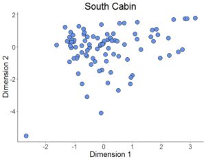
Figure 1. Plot of contexts along CA Dimensions 1 (Inertia 23.5%) and 2 (Inertia 16%). Time runs right (early) to left (late).
Intra-site Chronologies
DAACS has developed a uniform set of methods to infer intra-site chronologies for all of the sites included in the Archive. These methods, which include frequency-seriation and correspondence analysis, were developed by DAACS (see Neiman, Galle, and Wheeler 2003 for technical details). The use of common methods for all sites in the Archive is designed to increase comparability among temporal phases at different sites. The methods and the phase assignments they produced are summarized below. Archive users may also use the Mean Ceramic Date queries provided on the Query the Database section of this website to calculate mean ceramic dates (MCDs) for individual contexts or features.
For some sites, the original excavators developed intra-site chronologies and, where these exist, they are described on the Background page for the site. In the case of the South Cabin at the First Hermitage, the principal investigators did not develop a chronology for the site. The DAACS chronology presented here is the only current chronology for the site.
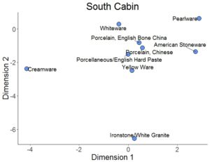
Figure 2. Plot of Ware Types along CA Dimensions 1 (Inertia 23.5%) and 2 (Inertia 16)%).
DAACS Seriation Method
As with other sites in the Archive, the seriation chronology for the South Cabin was derived from ceramic assemblages aggregated at the level of stratigraphic groups and individual contexts not assigned to stratigraphic groups.
To reduce the noise introduced by sampling error, only ceramic assemblages with more than five sherds were included. We excluded assemblages from unit clean-up and surface collections. The seriation chronology presented here is the result of a correspondence analysis (CA) of ware-type frequencies from contexts that meet these requirements (Figures 1 and 2).
After running an initial version of the CA, it was determined that three ware types (“Porcelain, English Soft Paste”, “‘Redware'”, and “Black Basalt”) had small sample sizes (<5) or were distributed randomly, i.e., their distribution showed no discernible pattern. Consequently, these ware types were removed from the CA because they were obscuring the patterning of ware types with larger sample
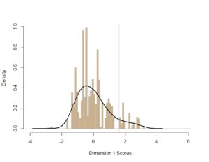
Figure 3. Histogram of ceramic counts plotted along CA Dimension 1. The lines indicate DAACs phase division, with phase 1 on right, phase 2 on left.
sizes. In addition, based on the occupation history of the South Cabin, the following modifications to ceramic ware manufacture dates in the CA were made: The Begin Date for “Porcelain, Chinese” was changed from 1600 to 1700; End Dates for “Whiteware,” “Ironstone/White Granite,” and “Porcelain, French” were changed to 1930.
The CA results produced a strong correlation between Dimension 1 scores and MCDs (Figure 4), suggesting that Dimension 1 represents time from left (early) to right (late). Based on the dips in ceramic counts observed in a histogram of Dimension 1 scores (Figure 3), where the vertical axis measures ceramic assemblage size, we divided the South Cabin into two occupational site phases (Figure 5).
Site Phases
DAACS Phases are groups of assemblages that have similar correspondence-analysis scores, similar MCDs, or both, and are therefore inferred to be broadly contemporary. Phases have a P-prefix that precedes the phase number (e.g. P01 equals Phase 1). Based on the correspondence analysis, DAACS divided the South Cabin occupation into two phases (Figure 5). Mean ceramic dates for the site-specific phases are given in the table below.
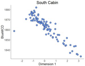
Figure 4. CA Dimension 1 scores for assemblages plotted against Mean Ceramic Dates.
MCDs and BLUE MCDs, which give less influence to ceramic types with long manufacturing spans, for each phase indicate that South Cabin was occupied throughout the nineteenth century. The table also provides three terminus post quem (TPQ) estimates. The first TPQ estimate is the usual one – the maximum beginning manufacturing date among all the ware-types in the assemblage. Two other TPQ measures included in the table below are less sensitive to excavation errors and taphonomic processes that might introduce a small amount of anomalously late material into an assemblage. They are TPQp90 and TPQp95. The TPQp95 of 1820 for phase 1 and TPQ95 of 1830 for phase 2 provide more robust estimate of the site’s TPQ based on the 95th percentile of the beginning manufacturing dates for all the artifacts comprising each phase.
South Cabin Dates and TPQs
| Contexts | MCD | BlueMCD | TPQ | TPQ90 | TPQ95 | Total Count |
|---|---|---|---|---|---|---|
| P01 | 1842 | 1818 | 1830 | 1820 | 1820 | 168 |
| PO2 | 1869 | 1855 | 1840 | 1820 | 1830 | 3,503 |
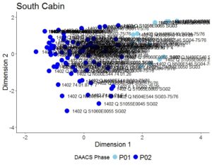
Figure 5. Plot of contexts along CA Dimensions 1 and 2, color-coded by DAACS phase and labeled with assemblage name.
About the Code
Incorporating data from the DAACS database, we perform the correspondence analysis through the R programming language (R Core Team 2014) to conduct the CA analysis. The CA code was written by Fraser D. Neiman. The following packages generate the data tables, CA, and plots within this code: RPostgreSQL (Conway et al. 2013), plyr (Wickham 2014), reshape2 (Wickham 2014), seriation (Hahsler et al. 2014), ca (Greenacre, Nenadic, and Friendly 2014), and ggplot2 (Wickham 2015).
All of the R code used in this analysis was written within the domain of the R Core Team at the R Foundation for Statistical Computing, Vienna, Austria (2014). The correspondence analysis for South Cabin was conducted by Leslie Cooper.
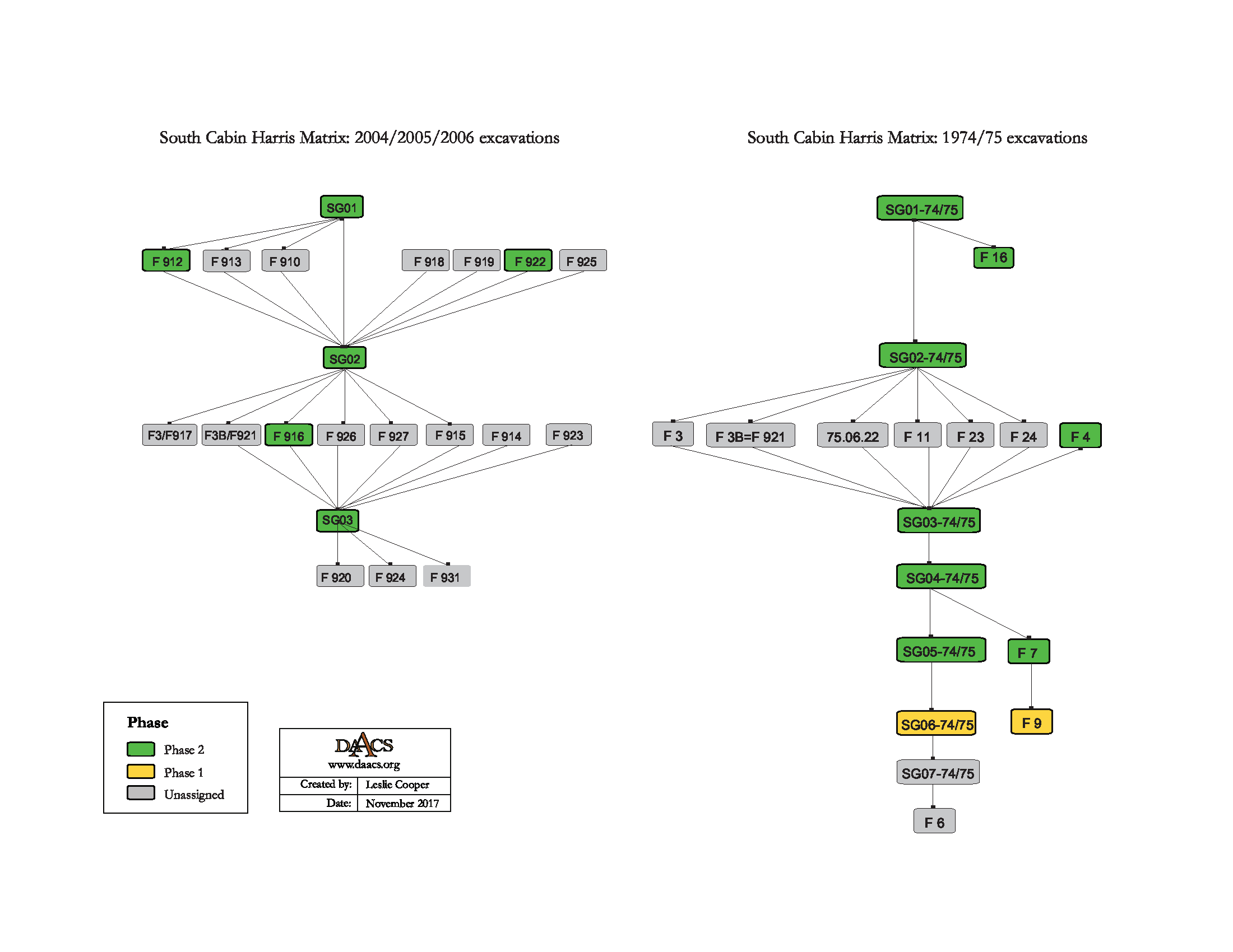
South Cabin Harris Matrix
The Harris Matrix summarizes stratigraphic relationships among excavated contexts and groups of contexts that DAACS staff has identified as part of the same stratigraphic group. Stratigraphic groups and contexts are represented as boxes, while lines connecting them represent temporal relationships implied by the site’s stratification, as recorded by the site’s excavators (Harris 1979).
Stratigraphic groups, which represent multiple contexts, are identified on the diagram by their numeric designations (e.g. SG01). Contexts that could not be assigned to stratigraphic groups are identified by their individual context numbers (e.g. 75-06-22).
There are two different stratigraphic group naming conventions for the South Cabin: One system refers to strata excavated during the 1974 and 1975 seasons (e.g., “SG01-74/75”) and one system refers to strata identified during the 2004, 2005, and 2006 seasons (e.g., “SG01”). This was due to the difficulty in establishing a single stratigraphic sequence for the site because two different ways of recording sediment and strata information were implemented (see South Cabin background: Excavation history, procedure, and methods). As a result, two separate Harris Matrices were generated to represent the relationships: one represents strata encountered during 1974/1975 seasons, and one represents strata for the 2004, 2005, and 2006 seasons.
See South Cabin Chronology for stratigraphic and phase information. Please note that some of the contexts present in the chronology analysis are not visualized on the Harris Matrix. The contexts that are not included do not have any stratigraphic relationships with other contexts. The lack of relationships can occur for a few reasons, but two common examples are 1) the artifacts are from a surface collection, which is entered into DAACS as a context but does not have recorded relationships to other contexts that are below it; 2) in cases where topsoil and plowzone are stripped and discarded, there may be features below the plowzone that are comprised of a single context. Since the plowzone does not exist as a documented context with artifacts, it cannot seal the single-context feature. DAACS also does not record subsoil as a context, so there is nothing for that single context feature to intrude or seal.
Stratigraphic group information was able to be merged for the 2004, 2005, and 2006 seasons. However, based on available information, it is difficult to integrate the stratigraphic groups identified from the 1974 and 1975 excavations with those from the 2000s excavations. As a result, two separate Harris Matrices were generated to represent the relationships: one represents strata encountered during 1974 and 1975 seasons, and one represents strata for the 2004, 2005, and 2006 seasons.
This Harris Matrix is based on data on stratigraphic relationships recorded among contexts in the DAACS database. It was drawn with the ArchEd application.
This Harris Matrix is based on data on stratigraphic relationships recorded among contexts in the DAACS database. It was drawn with the ArchEd application.
See http://www.ads.tuwien.ac.at/arched/index.html.
For a printable version, download the Harris Matrix [168 KB PDF].


PDF of composite South Cabin plan compiled by DAACS from original field drawings with features and quadrats labeled.
Battle, Whitney
2010 Sweepin’ Spirits: Power and Transformation on the Plantation Landscape, In Archaeology and the Preservation of Gendered Landscapes, S. Baugher and S.M. Spencer-Wood, editors. Springer
Battle, Whitney
2004 A Space of Our Own: Redefining the Enslaved Household at Andrew Jackson’s Hermitage Plantation, In Household Chores and Household choices: Theorizing the domestic Sphere in Historical Archaeology, edited by K. Barile and J. C. Brandon. University of Alabama Press, Mobile.
Battle, Whitney
2011 Black Feminist Archaeology, Routledge, New York.
Galle, Jillian E.
2004 Designing Women: Measuring Acquisition and Access at the Hermitage Plantation, Engendering African American Archaeology: A Southern Perspective In Engendering African American Archaeology: A Southern Perspective, edited by Jillian E. Galle and Amy L. Young. University of Tennessee Press, Knoxville, Tennessee.
Harris, Edward C.
1979 Principles of Archaeological Stratigraphy. Academic Press, London, England.
McKee, Larry
1995 The Earth Is Their Witness, The Sciences. March/April.
Russell, Aaron E.
1997 Material Culture and African-American Spirituality at the Hermitage Historical Archaeology, Vol. 31, No. 2 (1997), pp. 63-80.
Smith, Samuel D.
1976 An Archaeological and Historical Assessment of the First Hermitage. Tennesse Division of Archaeology Research Series No. 2. Published by the Tennesse Division of Conservation, Nashville, Tennesse.
Thomas, Brian W.
1998 Power and Community: The Archaeology of Slavery at The Hermitage Plantation. American Antiquity, Vol. 63, No. 4, pp. 531-551.
Thomas, Brian W., and Larissa Thomas
2004 Gender and Presentation of Self: An Example from The Hermitage, In Engendering African American Archaeology: A Southern Perspective. University of Tennessee Press, Knoxville.