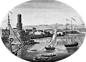


Port Royal, Jamaica
- The Project Gutenberg EBook of On the Spanish Main, by John Masefield
Welcome to the New Street Tavern gallery. This gallery explores some of the items recovered during excavations carried out in Port Royal, Jamaica by the Jamaica National Trust Commission in the early 1970s under the direction of Anthony J. Priddy. The excavations focused on the center of Port Royal, a city that was once a densely-populated bustling center of mercantile trade in the seventeenth century. Although the city was severely damaged by earthquakes, floods, and fires intermittently throughout the seventeenth, eighteenth, and nineteenth centuries, a portion of the original layout remained intact.1 Investigations revealed many different occupation levels and areas dating from the 1660s to the twentieth century. The assemblage from New Street Tavern provides a window into the lives of the people who lived and worked in the area.
This gallery is curated by Elizabeth Bollwerk and Leslie Cooper. Photographs taken by Karen Price, Historic Preservation Lab Manager and Photographer at Mount Vernon and Monticello Lab Staff Katelyn Coughlan and Elizabeth Sawyer.
1 Priddy, Antony 1975 The 17th and 18th Century Settlement Pattern of Port Royal. Jamaica 9(2) 1975. pg. 8-9.
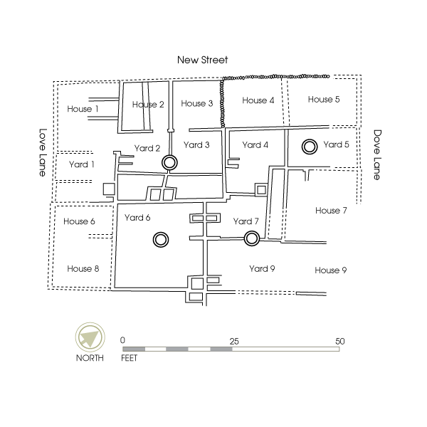
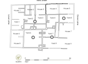
Site Map, New Street Tavern, Port Royal, Jamaica
- Map taken from Jean and Oliver Cox (1987).
Because of its prominent role as a center of international trade Port Royal served as the de facto capital of the Jamaica from 1660 to 1692.1 The city was located on the south coast of the island and rose in prominence because it was well-situated as a center of commerce between North America and Europe. Port Royal’s strategic location in the Caribbean made it a hub of commercial and illicit activity during the seventeenth and eighteenth centuries. It had the reputation of being one of the wealthiest and “wickedest” places in the world, as it was used extensively by pirates as a base of operations. Taverns were one of the most popular establishments during this time.
The city’s inhabitants enjoyed their heyday until June 7, 1692, when a high-force earthquake shook Jamaica. The quake claimed thousands of lives and destroyed much of the island’s property, sending all the waterfront buildings of Port Royal into the sea. Only one-third of Port Royal survived.2
The New Street Tavern was one of the buildings that survived the earthquake and subsequent tsunami and fires that destroyed much of the town. The site’s assemblage is comprised of artifacts from the seventeenth to the twentieth centuries. Antony Priddy and his team excavated the city block where the tavern was located between New Street, Dove Lane, and Love Lane in Port Royal. The tavern was a place that would have been frequented by a variety of characters both before and after the earthquake.
1 Hamilton, D.L. Pewterer of Port Royal. In Text-Aided Archaeology, edited by B.J. Little. 1992. pp. 40. CRC Press, Boca Raton, FL.
2 Brown, Maureen J. Evidence for Port Royal’s British Colonial Merchant Class as Reflected in the New Street Tavern Site Assemblage. In Out of Many, One People, edited by James A. Delle, Mark W. Hauser, and Douglas V. Armstrong. 2011. pg. 62. University of Alabama Press, Tuscaloosa.
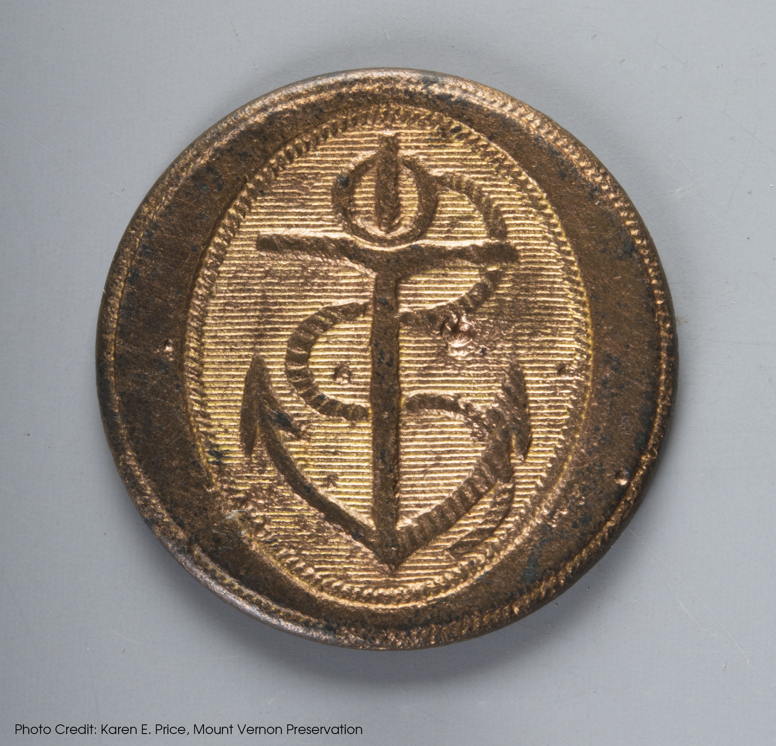
Royal Navy Button
- Cast
- ca. 1812
- England
- 23 mm diameter
Port Royal served as a Royal Naval Dockyard beginning in 1675. At one time, it was the headquarters of the British Caribbean fleet, with a British naval officer stationed there until 1905 when the yard closed. The naval presence was especially important in Port Royal following the outlaw of piracy in 1687. This Napoleonic Royal Navy button recovered from Area 5 of the New Street Tavern site would have been worn by an officer ca. 1812. It is gilt plated over copper alloy. The stamped decoration consists of an oval border with an anchor and intertwined rope. The oval has a background of horizontal lines. Its presence at the site is no surprise given the extent of social gathering, particularly of naval men, that likely took place at the tavern.
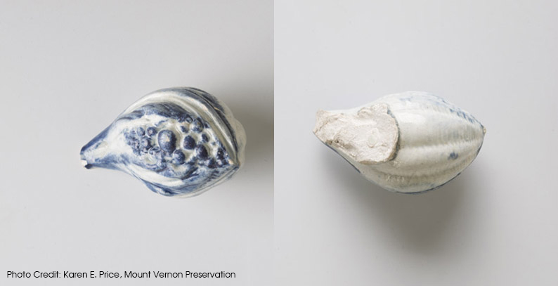
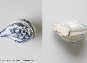
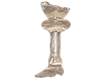
Pearlware Teaware Finial
- Eighteenth century
- England
Playing cards, dancing, dining, and drinking both alcoholic and non-alcoholic beverages, including tea, all took place at New Street Tavern. The Western practice of taking tea with sugar was exercised by the upper class and a growing middle class during the eighteenth century. It created great demand for the product, the largest export of the West Indies, putting Port Royal, Jamaica on the map. The act of drinking tea was regarded as a healthful endeavor by this demographic and also may have signaled and reinforced status in a social sphere that may have been unfamiliar for many visitors to Port Royal. This pearlware ceramic artifact is likely a finial for a teapot lid, formed in the shape of a botanical element, possibly a fig. It has hand-painted detailing, executed in cobalt blue.
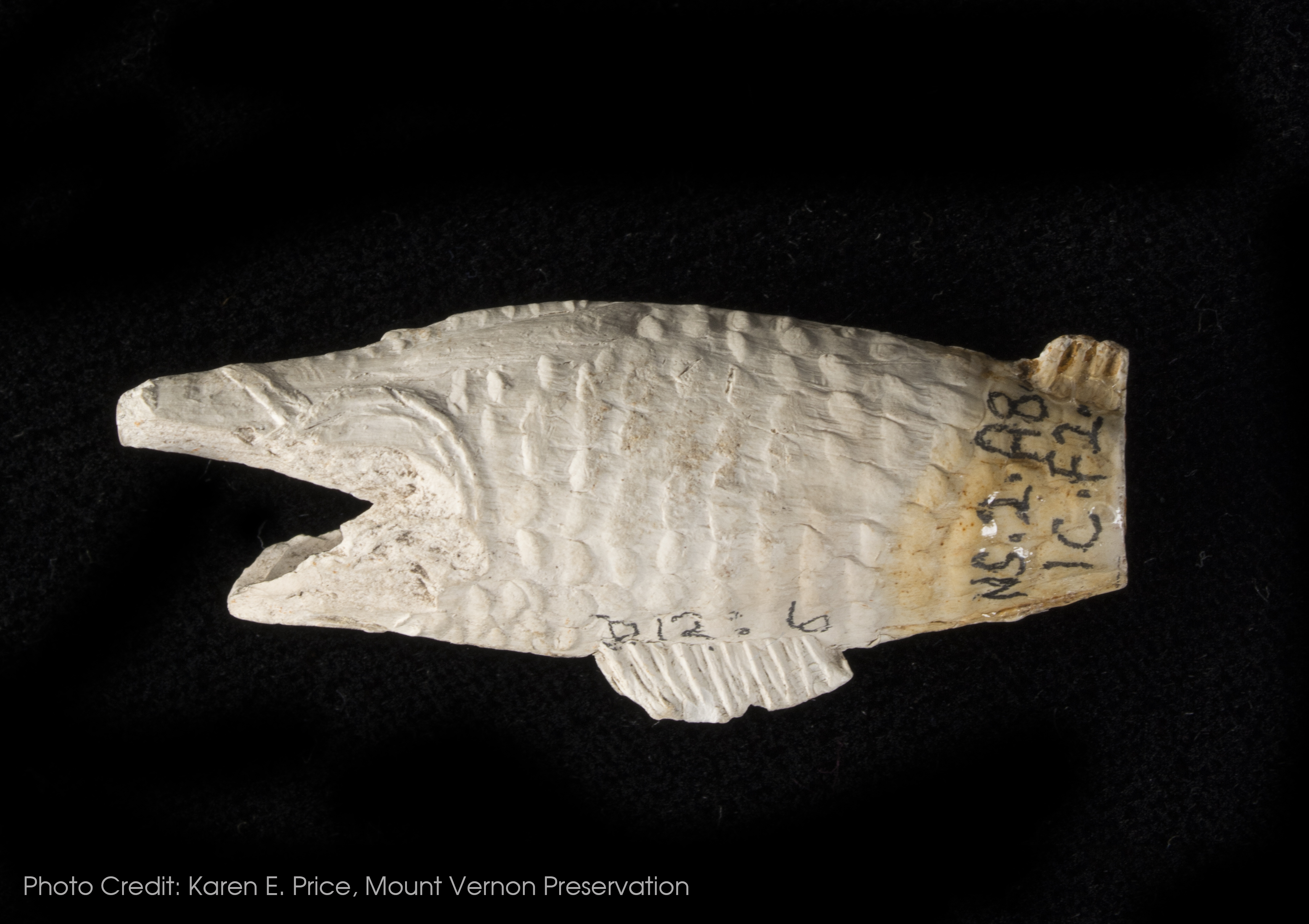
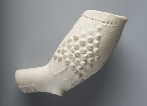
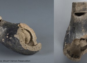
White Ball Clay Molded Fish Pipe
- Molded
- Eighteenth Century
- England or the Netherlands
Pipe smoking was another popular recreational past time enjoyed by New Street tavern visitors and Port Royal inhabitants. More than 2,148 pipe fragments were recovered from the excavations.1 A variety of pipes were found at the New Street Tavern with various molded decorations. However, this ball clay pipe bowl fragment molded into the shape of a fish is the most unusual specimen. The bowl is oriented so that smoke would have exited through the fish’s mouth. Due to the breakage of the stem right at the base of the bowl it is difficult to tell if this was a tubular pipe (where the bowl sits in a straight line with the stem) or an elbow-shaped one (where the bowl sits at an angle to the stem). No matter what the orientation, this pipe certainly would have been a conversation starter!
1 Brown, Maureen J. Evidence for Port Royal’s British Colonial Merchant Class as Reflected in the New Street Tavern Site Assemblage. In Out of Many, One People, edited by James A. Delle, Mark W. Hauser, and Douglas V. Armstrong. 2011, pg. 62.
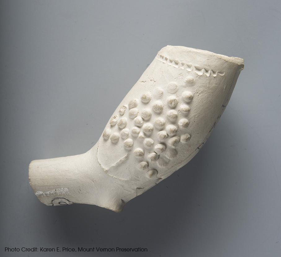
White Ball Clay Molded Pipe Bowl
- Molded
- Late seventeenth - Early eighteenth century
- Derby, England
While not as eye-catching as the fish pipe, this pipe bowl is also ornately decorated. The ball clay bowl, juncture, and stem fragment is from an elbow pipe. The molded decoration is repeated on both the left and right side of the bowl. It includes an anchor situated underneath what look like stacked circular objects. The pipe also had a spur or heel at its base, which has been broken.
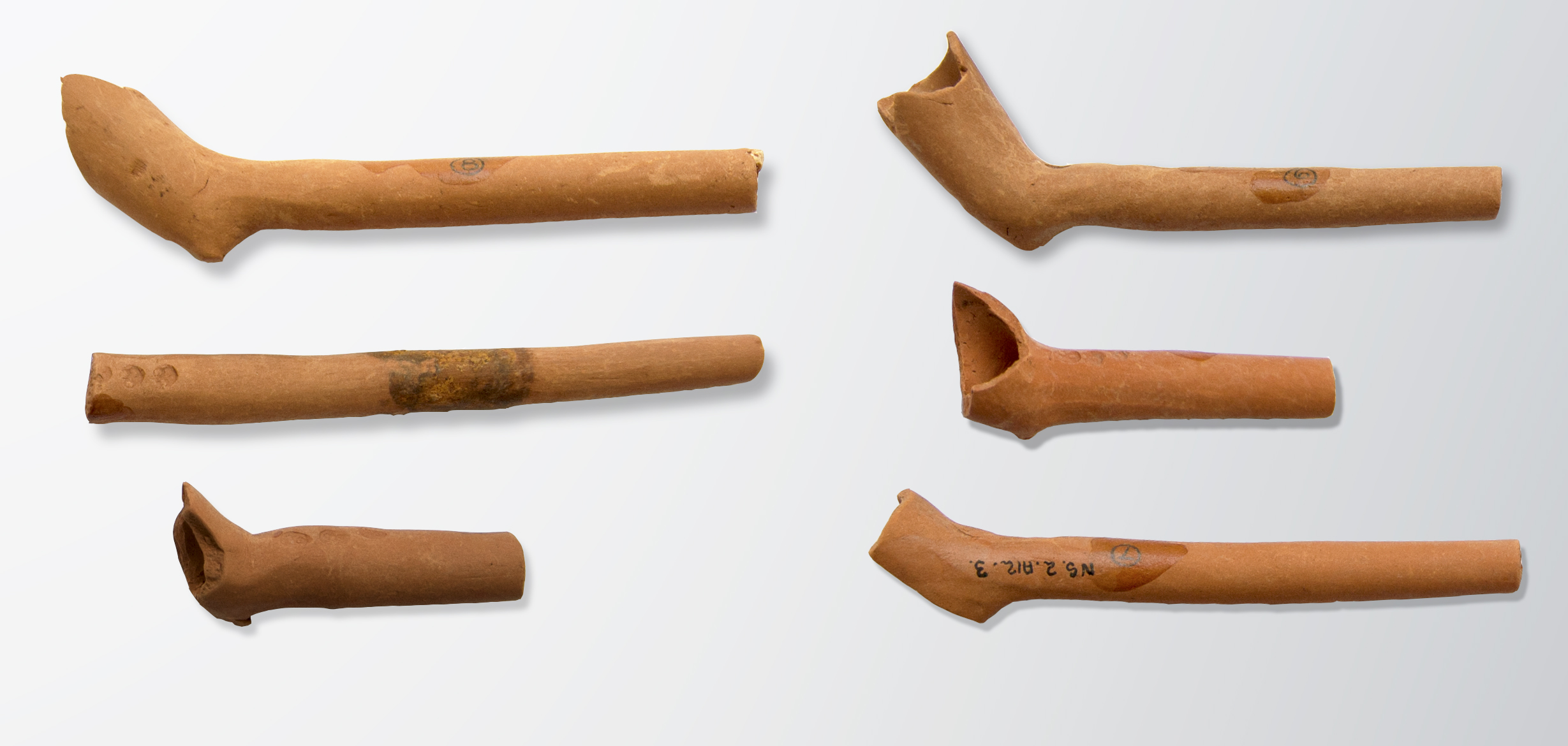
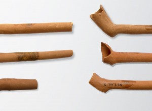
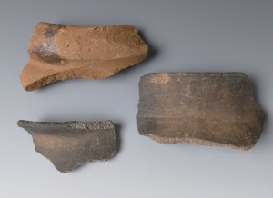
Locally-made pipes
- Handmade
- Seventeenth century
- Jamaica
In addition to being a center of international commerce Port Royal was home to a local pipe-making industry. Hundreds of red clay pipes, made from local Jamaica clay, were found during excavations of New Street Tavern. Seventy-three percent of the red clay pipes from New Street came from levels believed to be contemporary with the earthquake.1 Although these pipes are thought to have been made to resemble European-manufactured pipes,2 there is no indication they were molded. Irregularities in their shape, lack of uniform thickness, and finishing techniques indicate they were likely handmade. Although the documentary record does not provide a lot of information on possible makers the 1711 inventory of James Hurst notes several “gross of Negro pipes” that Meyers 3 thought were crafted from the island’s red clay. John Taylor, an Englishmen who visited Port Royal in the late 1680s also noted that red clay pipes were made by “Negros.” 4 Moreover, while thousands of pipe fragments have been found at Port Royal red clay pipes have also been found at sites associated with enslaved individuals on other parts of the island, including Seville on the north coast. 5 Regardless of who was making them the variety of markings present on pipes in the assemblage—believed to be maker’s marks—suggests a large number of individuals were involved in their manufacture. The markings occur most often at the juncture of the bowl and stem that faces the smoker and consist of repeating small impressed stamps or lettering.
1Heidtke, Kenan Jamaican Red Clay Pipes. MA Thesis, Texas A&M University, College Station. 1992. pp. 105
2Heidtke 1992:47
3Meyers, Allan D. West African Tradition in the Decoration of Jamaica Folk Pottery. International Journal of Historical Archaeology 3:4 1999. pp. 202
4Heidtke 1992:82
5 Armstrong, D. V. Archaeology and ethnohistory of the Caribbean plantation. In I, Too, Am America: Archaeological Studies of African-American Life. Edited by Teresa A. Singleton, University Press of Virginia. 1999. pp. 173-192. Also see data for Seville available on daacs.org.
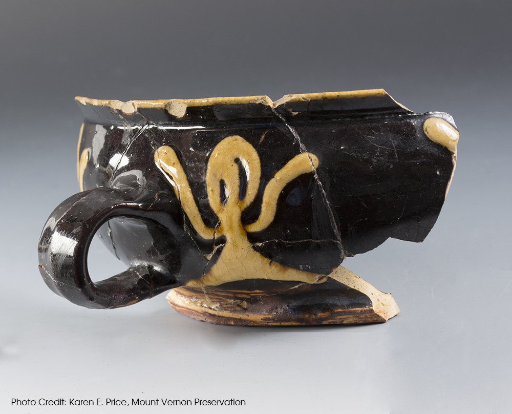
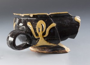
Slipware Cup
- Wheel thrown
- Eighteenth century
- England
Though most of the artifacts in the New Street Tavern gallery were manufactured after the devastating 1692 earthquake at Port Royal, this is likely the oldest artifact showcased. The North Midlands or “Staffordshire” slipware cup was likely produced in the early eighteenth century and may have held cold or warm beverages at the tavern. The “light on dark” slip decoration may be attributed to Derbyshire.1 It features decoration reminiscent of “raised arm” foliage seen on similar examples of slipware that date to the same time period.
1 Grigsby, Leslie 1990 The Hentry H. Weldon Collection: English Pottery 1650-1800 1990. pg. 160-161.
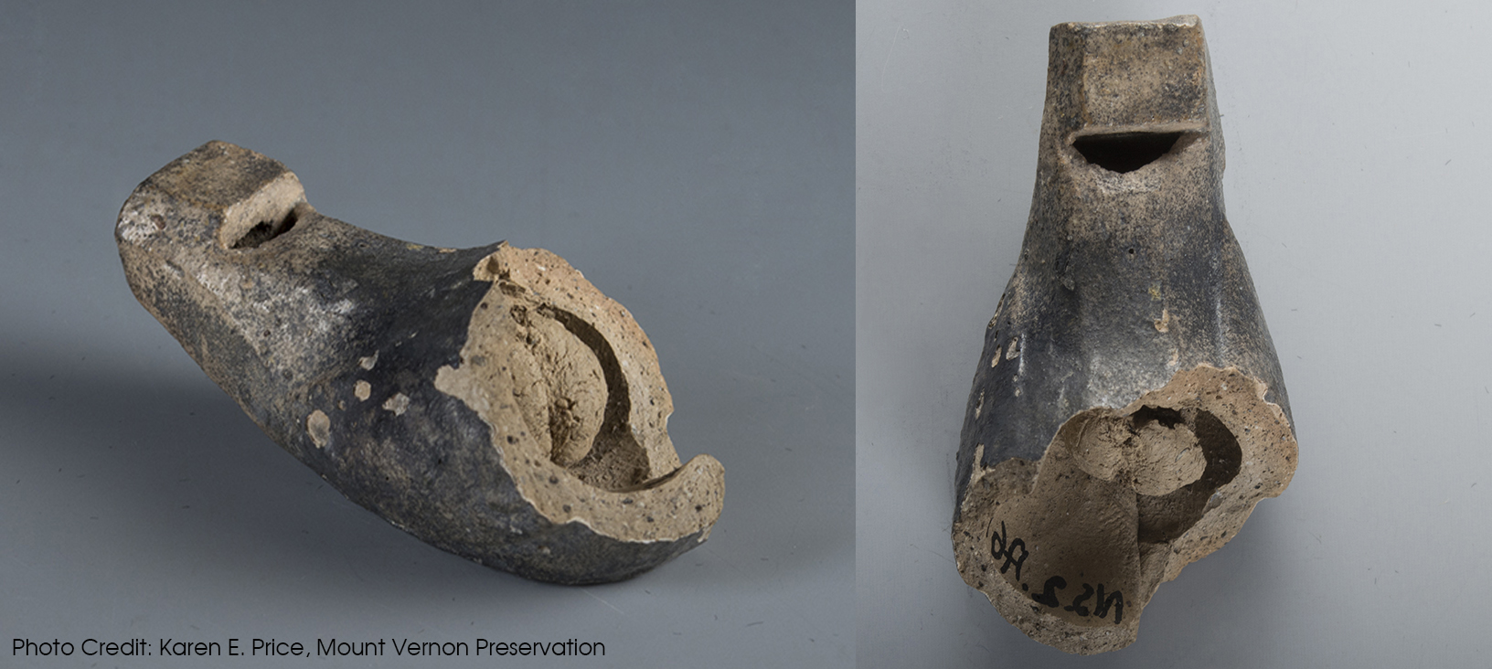
Coarse Earthenware Whistle
- Handmade
- Likely produced in eighteenth century
This whistle is perhaps one of the most interesting artifacts recovered from the New Street Tavern site. It is made of coarse earthenware and was likely produced on the island by an enslaved individual. In addition to the large amount of earthenware, stoneware, and porcelain that was imported and used by Jamaica’s inhabitants in their daily lives, coarse earthenwares continued to be locally produced, bought, and sold at market by the enslaved during the eighteenth and nineteenth centuries. Though most of the Caribbean coarse earthenware vessels recovered archaeologically were either utilitarian storage vessels or cooking pots, one can imagine that a whistle might serve a handy function as well!
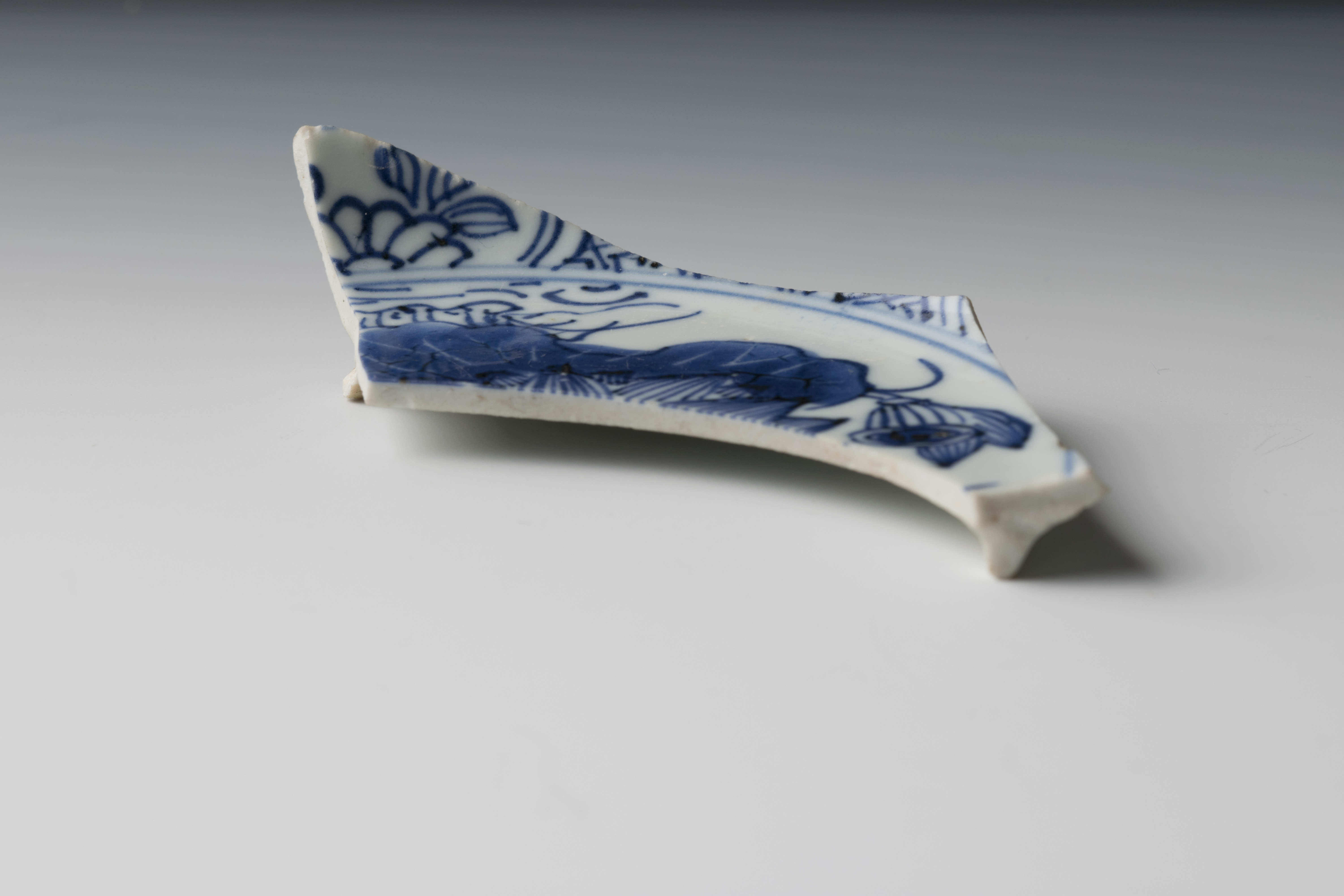
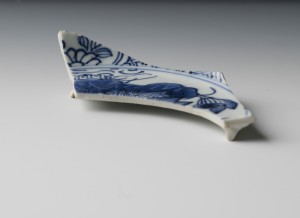
Chinese Porcelain Saucer
- Press molded
- Likely produced in the seventeenth or eighteenth century
- China
- Length - 100 mm, Base diameter is 80mm
This base fragment of a Chinese Porcelain saucer exhibits a finely handpainted scene with botanical elements on the interior surface and adjacent botanical and trellis band designs circling the interior of the body. Seventeenth-century Port Royal may have been a wicked place, but merchants and other individuals also used their new-found wealth to display genteel qualities. Brown1 has suggested that the merchants of Port Royal gathered in taverns to socialize and display their developing gentility as a means to signal their high status. Using high-end Chinese Porcelain teawares would have allowed tavern visitors to take part in the tea ritual and enjoy drinks other than alcohol while showing off their status.
1 Brown, Maureen J. Evidence for Port Royal’s British Colonial Merchant Class as Reflected in the New Street Tavern Site Assemblage. In Out of Many, One People, edited by James A. Delle, Mark W. Hauser, and Douglas V. Armstrong. 2011. pg. 57-58.
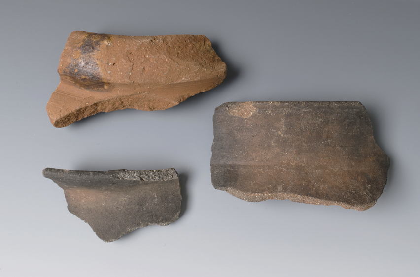
Caribbean Coarse Earthenware
- Wheel thrown and handbuilt
- Eighteenth and nineteenth century
- Jamaica
Enslaved Jamaicans produced and traded locally-made coarse earthenware during the eighteenth and nineteenth centuries up until emancipation. Following that, the pottery tradition continued until the twentieth century with late potters like Ma Lou and her granddaughter, Marlene “Munchee” Rhoden. Munchie continues to produce ceramics in Spanish Town today. There is archaeological evidence for both a small-scale production of vessels that satisfied household cooking and meal preparation needs of the enslaved, and larger-scale cottage industry manufacture of vessels produced for water and possibly plantation-wide storage needs. Vessel form, inclusions in the paste or the fabric of the pottery, and evidence of the way the vessels were fired are all attributes recorded in the database and serve as clues that help archaeologists determine how the pottery was used.
The top sherd is the rim of a large storage jar or vessel and the bottom two sherds are rims of smaller jars that were likely used for cooking. The paste of the top vessel indicates that it was likely fired in a controlled environment like a kiln, indicative of larger-scale manufacture, and also exhibits signs of being “thrown” on a potter’s wheel. The other two sherds may have been open-fired without the use of a kiln, a method indicative of smaller-scale, household production.

Soft-Paste Porcelain
- c. 1800
Factories in England began producing their attempts at a facsimile of Chinese porcelain, known as “English soft paste,” as early as the 1740s and continued until the turn of the nineteenth century. The paste of the English version, often described as “chalky,” lacked the key ingredient in Chinese porcelain, kaolin. Much of the wares were transfer printed in an attempt to reduce cost and compete with hand-painted Chinese export porcelain sought after by consumers until refined earthenwares usurped their popularity. This mug fragment was printed with a variant of the popular pattern that would later be called “Willow” after 1810 and features a fig tree with a pagoda and other chinoiserie elements. It was likely produced around 1800.
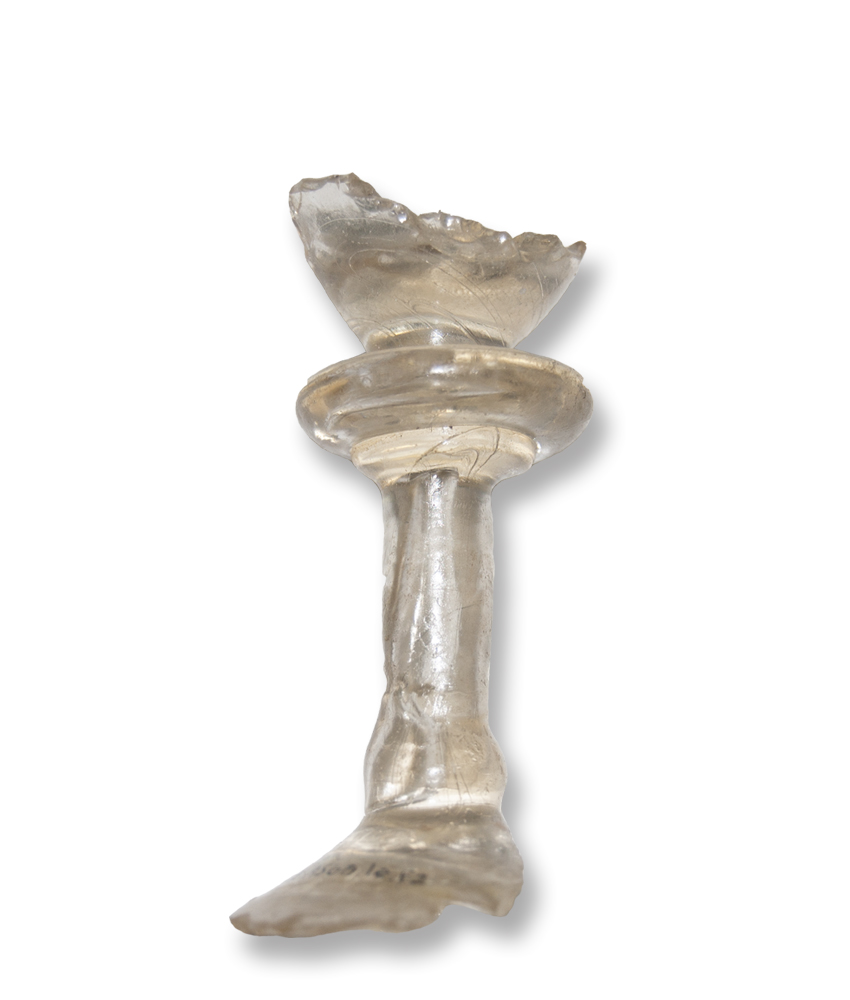
Leaded Drinking Glass
- Free blown
- 1685-1720
Much time was spent imbibing while socializing at taverns during the eighteenth century. This leaded drinking glass fragment recovered from the New Street Tavern excavations features a heavy baluster with a large knop and a plain foot. Heavy balusters were popular on stemware between 1685 and 1720. The knopped stem allowed the drinker to safely grasp the heavy glass. During this time, it was customary to lift the glass with the left hand and carry it to the lips by “grasping the foot between the first finger and thumb of the right hand.”1
1 Hughes, G. Bernard English, Scottish & Irish Table Glass. 1956. pg. 76-86.