| Location: | Soufriere, Dominica |
|---|---|
| Occupation Dates: | Late 18th-19th centuries |
| Excavator(s): | Mark Hauser, Khadene Harris, Isaac Shearn |
| Dates excavated: | 2015, 2016 |

Overview
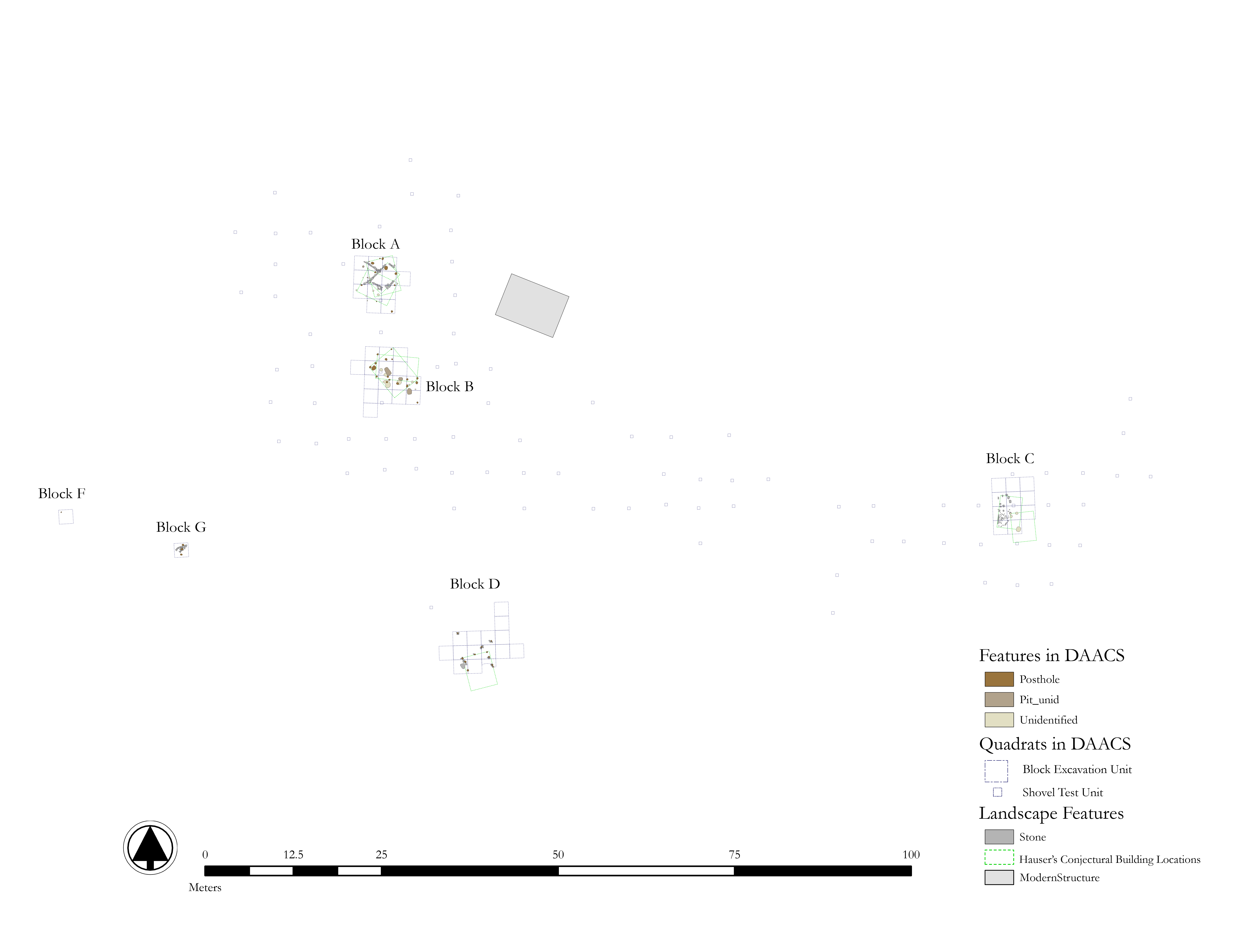
Locus 2 Site Map. See Maps and Images page for downloadable shape files and pdfs of this map.
Locus 2 encompasses the village for enslaved laborers, and was divided into six excavation blocks: House Areas A, B, C, D, F, and G. Excavation blocks were undertaken in one or more two-meter quadrats. Artifact density suggests that there was an increase in occupational intensity during Phase 2, with further increase during Phases 3 and 4, with a significant decline in Phase 5. Archaeological evidence from the village indicates that the spatial dimensions changed to become more regimented over time. It was located on a hillside near the plantation’s road. Survey and testing in 2011 and 2012 revealed evidence of a village with approximately 32 house platforms situated in the mountainside. From this identification, eight platforms (A-H) were excavated. Excavations revealed features that included foundations, stone flooring, hearths, middens, postholes, living surfaces, and storage pits.
Documentary Evidence
Although there is little documentary evidence between 1745 and 1763, when the island was annexed by Great Britain, a 1777 indenture between Nicholas Belligny and his heirs provides some insight into the enslaved quarters in the 18th century. The indenture indicates that there were 117 enslaved people living in 35 houses who worked on both Upper Soufriere Estate and Lower Soufriere Estate, which would become Morne Patate (Murphy and Hauser 2020:145). This number grew slightly by a 1784 probate inventory, which included 120 enslaved laborers living in 36 houses. This probate documentation is also significant, because it includes evidence of sugar processing infrastructure, indicating by this point laborers at Morne Patate had transitioned to producing sugar. An 1817 register lists the number of enslaved laborers at Morne Patate at 166: the largest number of enslaved people that were recorded living at the plantation during its history (Murphy and Hauser 2020:46). In 1827 the Dominica Assembly indicated that 121 enslaved laborers lived at Morne Patate and produced 21,000 pounds of sugar and 25,075 pounds of coffee. People continued to live and work at Morne Patate after the abolition of slavery in 1833 (Murphy and Hauser 2020:46). The production of coffee declined during this period due to a coffee blight in the 1830’s, however sugar continued to be produced. Beginning in the late 19th century, however, corporations in Soufriere began a market for limes, and workers began cultivating lime trees in fields that once produced sugar (Murphy and Hauser 2020:47).
Excavation history, procedures, and methods
View through Morne Patate Locus 2, Village for Enslaved Laborers.
The village was identified during field seasons in 2015 and 2016. Excavation began with .4 x .4 meter shovel test pits (STPs) using natural stratigraphy, with each level within an STP assigned its own Field Specimen Number (FS). STPs were excavation until archaeologists reached sub soil, obstruction by rocks, or the excavation integrity was compromised, usually at approximately 1 m. Soils were screened through ¼ inch mesh and all artifacts were recovered. All artifacts and their associated field records were sent to the DAACS lab at Monticello for analysis and entry into the DAACS database. This process both revealed the extent of the village, changing organization, and a garden about 100 m away from the eastern limit of the village, which was likely the provision ground (Locus 3).
During this same period, 71 2×2 meter units were excavated. All soil was sifted and both micro and macro artifacts recovered. Identified features were recorded, mapped, and excavated at each level, and soil from these features, such as middens, post holes, floors, and heaths, were collected for flotation. Four 2×2 m units were also excavated. Two of these were used to further identify a garden during mapping, while the second two expanded a kitchen midden during the first phase of research. Additionally, in 2016 volunteers working with William Keegan at the Florida Museum of Natural History excavated 1×1 meter test units in order to better situate the primary settlements, defined as the Estate House and Dependencies (Locus 1), the Village (Locus 2), and the Provision Grounds (Locus 3). In 2017, archaeologists returned and excavated an addition 8 2×2 meter units in order to expand House Area G. Materials and contexts from these excavations were recorded into DAACS (Hauser 2020a).
House Areas A & B
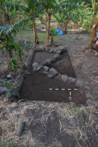
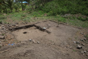
Locus 2, House Area A foundations.
HAs A and B were the first areas in the village to be excavated (Harris 2020:105). The area was being prepared for crops, and consequently surface deposits were heavily disturbed. HA A was likely the longest occupied, indicated by an MCD of 1733. The earliest phase was likely constructed of wattle and daub with a compact dirt floor. The house orientation was later shifted, and the building materials changed to stone foundations and plank walls. Stone alignments of the cooking hearth excavated from Phase 2 indicate that the alignment was changed at least twice. Flotation samples indicate that residents of HA A grew maize and millet before the change to sugar agriculture, and added guava, passionfruit, okra, and coffee after (Harris 2020b:105).
HA B is located approximately 4 m south of HA A and is a similarly sized yard space (Harris 2020:105). It was constructed using plank walls and posts and was likely constructed in the early nineteenth century and occupied through the post emancipation period. Two cooking pits and a midden indicate that the structure was reoriented, and flotation samples indicated that inhabitants grew millet, sorghum, and barley in addition to guava and passionfruit (Harris 2020:105).
House Area C
 HA C is located approximately 50 m northeast of HA’s A and B. Stone features were still visible on the surface, and excavations uncovered an area that was probably inhabited from the nineteenth century through the post emancipation period. Floatation samples produced less variety of botanical samples than other house areas with longer occupation, and included maize, guava, and passionfruit.
House Area D
HA D was excavated in 2016 and, like HA A and B, was heavily disturbed due to crop rotation. French-made tin enameled wares were recovered from the earliest phase of excavation, which suggests that the first structure pre-dated the introduction of sugar. The earliest phase of occupation has an MCD of 1783 and the latest has an MCD of 1823: ten years before the abolition of slavery (Harris 2020:105). This time frame is different than the other house areas excavated, material culture assessments of the site’s assemblage suggest it residents were not enslaved. HA D was located nearest the estate house and had the highest proportion of French earthenwares. Flotation samples indicated crops including maize, guava, and passion fruit (Harris 2020:105).
House Areas F and G
HAs F and G were excavated in 2017 and uncovered a plantation road made of cobles that was likely constructed in the 1780’s. They are located between the enslaved village and the estate house. The layout of the yard and the material culture associated with the domestic structures indicate they were inhabited by indigenous Dominicans (Harris 2020:106).
Summary of Research
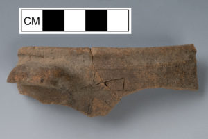
Morne Patate Coarse Earthenware with handle and incising along the rim.
Research at Locus 2 has focused on how enslaved laborers used and defined space through house yards (Harris 2020), subsistence practices and landscape use (Wallman and Oas 2020), and on sourcing coarse earthenware ceramics (Bloch and Bollwerk 2020). DAACS has developed detailed chronologies for Locus 2 (see Locus 2 Chronology page), and for the entire estate that allows for comparison among the three Morne Patate loci and other archaeological sites in DAACS (Bates, Galle, Neiman 2020). Archaeology in Dominica: Everyday Ecologies and Economies at Morne Patate, edited by Mark W. Hauser and Dianne Wallman, contain these articles as well as broad historical and archaeological review of the estate. Hauser’s forthcoming book, Mapping Water on Dominica: Environment and Enslavement under Colonialism Culture, Place and Nature, places the role of water and water use at Morne Patate into the broader context of Colonial Dominica (2021).
DAACS Plantation-wide Chronology
Locus 2 includes excavation Blocks A, B, C, D, F, and G. Bates, Galle, and Neiman combined the phased assemblages from Blocks F and G, which are near each other and have small samples, into a single Block FG (2020). The phased bar charts reveal an order-of-magnitude increase in deposition in Blocks C, D, and FG during Phase 2. A similarly large increase occurs in Block A during Phase 3 and in Block B during Phase 4. During these same two phases, deposition at Blocks FG and D (respectively) drops off. All five blocks show precipitous drops in deposition in Phase 5. Only Block A and B remained occupied during the final phase.
The foregoing patterns of change in the different excavation blocks support the hypothesis of two punctuations in settlement location, one during the early decades of British control and one at emancipation. Phase 2 witnessed a decline in the intensity of occupation and perhaps eventual abandonment of the estate area. This may have been ultimately linked to the economic and political uncertainty that plagued the Caribbean in the wake of the American Revolution. Simultaneously, there was a massive increase in deposition (and number of enslaved people responsible for it) into the village-area blocks, followed by continued increases in Blocks A, B, and C. This corresponds with the increase in enslaved laborers indicated by historical documents discussed by Hauser (2020b). This is followed by a precipitous decline at the Phase 4–5 transition, which Bates et al. suspect is coincident with emancipation. However, some newly freed workers remained in Block A and B areas. Meanwhile, the estate area was reoccupied in Phase 4 and the occupation continued into the post-emancipation period.
House Yards
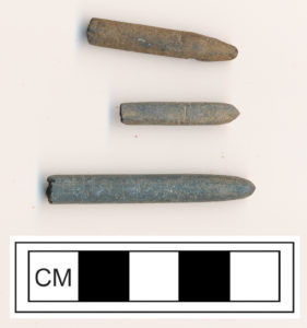
Three of the six slate pencils found in excavations at Locus 2.
Archaeological evidence suggests that Morne Patate’s pre-1770 house yards were large and not arranged in a centralized village (Harris 2020:109). Archaeologists have suggested this change in the house yards occurred for the following reasons. Morne Patate began as a provisioning estate, and therefore resulted in different labor relations and living arrangements than a large sugar plantation. Once the estate began to produce sugar, the number of enslaved houses increased, and the village became more consolidated. This resulted in shifts in the house yard layout and construction and size of houses. Following emancipation, plantation life changed again but there is less material evidence of this than from the change to sugar production (Harris 2020:109). Some evidence of these changes, however, include cut-stone flooring and foundations and the intensification of storage pits.
Additionally, materials recovered from this later time period indicate that inhabitants learned to read and write, and the diversification of economic networks (Hauser 2020a). The wide range of time periods represented in the village demonstrate the ways that life changed on Morne Patate after British annexation, the introduction of sugar, and emancipation.
Comparative Analysis of Carved Ceramic Discs
Bates. Galle, and Harris (2017) are currently exploring
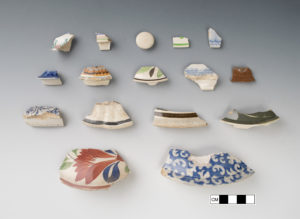
An unusual number of lids were found at Locus 2, many made in ceramic ware types dating to the post-emancipation period.
patterns in carved ceramic disc distribution at Morne Patate, and its relationship to carved discs on other sites of enslavement across the Caribbean and North America. Seventy-six carved ceramic discs were recovered during two seasons of excavation at Morne Patate. 75 were excavated from within the village and one was found in a cooking pit near the estate house.
A majority of the carved discs were found in excavation Block B, with excavation Block A having the second largest quantity. Figure # shows the gaming pieces from Morne Patate grouped by the units in which they were found, with the largest group representing Block B in the center and Block A in the north. Each large circle represents 10 discs and the smallest circle represents one disc.
Several attributes indicate that enslaved people made these discs within their homes and yard spaces at Morne Patate. Bates et al. inferred that the stages of gaming piece production began with an initial rough “cutting” of facets followed by a smoothing or grinding effort to achieve a rounded shape (2017). These manufacturing stages are represented in the assemblage. They identified a handful of discs as “preforms,” sherds likely still being worked into discs. Others were roughly knocked out discs, with three-quarters rounded edges and one flat side, while others have many “faceted” or worked edges that roughly turned the sherd into a round disc. Some discs were perfectly round with smoothed edges that indicate either heavy investment in manufacture or a well-used disc that has been worn smooth. Thus the decorative and manufacturing evidence point to on-site production of discs from vessel fragments.
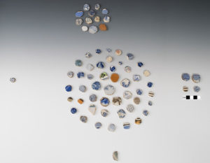
Carved ceramic discs found at Locus 2, the Village. The discs are arranged by house area within Locus 2, with House Area B representing the largest circle in the middle.
Bates et al.’s attribute-based analysis of the Morne Patate assemblage reveals provocative evidence for off-time activities, the opportunity for which likely
would increase after Emancipation (2017). The chronological signature of the discs also presents possible routes for further research. Mean ceramic dates for excavation Blocks A, B, and the village as a whole hover around emancipation (1838). When the contexts in which the gaming discs were found are highlighted on a correspondence analysis plot of village contexts, one sees that a majority of the contexts fall in the post-emancipation period. Furthermore, 75 discs were made from whiteware vessels, and 24 exhibit decorations that were not produced in England until 1840 or 1845. This assemblage thereby informs future archaeological analysis of the post-Emancipation period on Dominica and the Caribbean more broadly.
Emily Schwalbe, Mark Hauser, Jillian Galle, Lynsey Bates, and Fraser Neiman
Northwestern University, Northwestern University, DAACS, DAACS, and Monticello Department of Archaeology
January 2021
Context IDs
The DAACS Project ID for the Morne Patate village for enslaved laborers is “1243.” All contexts and artifact IDs begin with that prefix. A field specimen (FS) number assigned to individual contexts follows the Project ID for Contexts and Artifact IDs. For example, Unit N4957 E6606 Level 1 was assigned the FS number “5144” in the field; the DAACS context ID is “1243-5144.” Features were also assigned FS numbers. Quadrat IDs were assigned based on the NE corner coordinates.
Unit Type
In DAACS, shovel test pits (STPs) are defined as excavation units that are not subdivided by level, such that each context contains materials from all of the levels (if applicable) excavated within the unit. The excavation strategy differed from this approach in that smaller units (0.4 x 0.4 m) were designated as STPs. Due to the differences in recording, the Unit Type for these smaller units is recorded as “Quadrat/Unit” not “STP.” The excavator’s STP designation can be found in the Excavator Description and Master Context Number fields.
Grid Systems
The Village encompasses the following excavation areas at the Morne Patate plantation: Blocks A, B, C, D, F, and G; STPs (recorded as quadrats/units in DAACS) with Easting coordinates greater than 6554 and equal to or less than 6734.
2 x 2 m units were laid out with a tape and a compass on a slope, while 0.4 x 0.4 m units were recorded with a transit.
Excavation Measurements
All measurements are in meters.
Stratigraphy
All deposits were screened through quarter-inch mesh hardware cloth during all seasons. Samples from deposits of particular interest were floated. Stratigraphic groups do not correspond across excavation blocks/house areas; each excavation block is assigned separate stratigrapic groups, e.g., “BlockA_SG01.”
Cataloging
The Morne Patate Village materials were cataloged using DAACS Lite Protocols. DAACS Lite cataloging protocols leverage two strategies to streamline cataloging: the reduction in the number of fields for which to record data and use of broader batching categories for some categories of artifacts. The desire to use the database to enter “abridged” data was the impetus for developing DAACS Lite protocols. The “full” DAACS data recording protocols, developed through consultation with various material culture experts, have been used for the majority of sites in the database and will continue to be used for most of the sites entered in the future. If you would like more information about the DAACS Lite protocols, please contact us.
Acknowledgements
Field records and artifact assemblages from Morne Patate Locus 2 were analyzed and cataloged by Dr. Lynsey Bates (DAACS Senior Archaeological Analyst), Ms. Leslie Cooper (DAACS Senior Archaeological Analyst), Dr. Elizabeth Bollwerk (Project Manager for DAACS), Colleen Betti (DAACS Summer Analyst), and Khadene Harris (DAACS Postdoctoral Fellow). Alan Armstrong (Northwestern), Mark Hauser (Northwestern) and Lindsay Bloch (Former DAACS Analysts, currently FLMNH) cataloged a small amount of artifacts from Locus 2. Leslie Cooper created the ArcGIS site maps, pdfs, and pngs using files provided by Mark Hauser. Lynsey Bates produced the Harris Matrices and Correspondence Analysis chronologies.
National Science Foundation, Archaeology Program (BCS 1419672, BCS 0948578), the Wenner-Gren Foundation for Anthropological Research (Gr 8413), and Northwestern University’s Faculty Research Grant. Material support came from Island Heritage Foundation for logistical support Dominica and Lands and Survey Division of the Ministry of Housing provided important geospatial information. Permission for research was granted through the Dominica’s Ministry of Education.
Feature Numbers
The original excavators of the Morne Patate Village site assigned consecutive numbers to individual features; features assigned by the excavators have an F-prefix.
DAACS assigned feature numbers (F139, F140, F141) to architectural features documented, but not numbered in the field.
Several features noted in the field were determined to be “unnumbered features.” These include: Block G – FS6257, originally assigned feature number 140; Block G – FS6258, originally assigned feature number 141.
For some features, although matrix type was recorded as “Postmold,” there is no evidence in the description or interpretation to suggest that there was a postmold present. Deposit type is recorded as “Fill.”
| Feature | Feature Type | Contexts |
|---|---|---|
| F001 | Posthole | 5101 |
| F002 | Posthole | 5102 |
| F003 | Unidentified | 5148 |
| F004 | Posthole | 5146 |
| F005 | Unidentified | 5147 |
| F006 | Unidentified | 5149 |
| F007 | Unidentified | 5150 |
| F008 | Unidentified | 5151 |
| F009 | Unidentified | 5152 |
| F010 | Posthole | 5153 |
| F011 | Posthole | 5156 |
| F012 | Posthole | 5157 |
| F013 | Posthole | 5159 |
| F014 | Pit, unidentified | 5176, 5184 |
| F015 | Posthole | 5178 |
| F016 | Posthole, possible | 5179 |
| F017 | Posthole, possible | 5180 |
| F019 | Posthole, possible | 5182 |
| F020 | Unidentified | 5183 |
| F021 | Posthole | 5186 |
| F022 | Posthole | 5187 |
| F023 | Posthole | 5188 |
| F024 | Posthole | 5189 |
| F025 | Unidentified | 5190 |
| F026 | Posthole | 5193 |
| F027 | Posthole | 5195 |
| F028 | Posthole | 5197 |
| F029 | Posthole | 5198 |
| F030 | Unidentified | 5400 |
| F031 | Unidentified | 5402 |
| F032 | Posthole | 5403 |
| F033 | Unidentified | 5404 |
| F035 | Posthole | 5408, 5423 |
| F036 | Posthole, possible | 5409 |
| F039 | Pit, unidentified | 5412 |
| F040 | Pit, unidentified | 5413 |
| F043 | Unidentified | 5419 |
| F044 | Unidentified | 5420 |
| F045 | Posthole | 5421 |
| F046 | Posthole, possible | 5427 |
| F047 | Unidentified | 5334 |
| F048 | Unidentified | 5337 |
| F049 | Unidentified | 5338 |
| F050 | Posthole | 5340, 5341 |
| F051 | Pit, unidentified | 5342 |
| F052 | Posthole | 5343 |
| F053 | Posthole | 5344 |
| F054 | Posthole, possible | 5345 |
| F055 | Unidentified | 5348 |
| F056 | Pit, unidentified | 5349 |
| F057 | Posthole | 5350 |
| F058 | Posthole, possible | 5351 |
| F059 | Unidentified | 5362 |
| F060 | Posthole | 5352 |
| F061 | Unidentified | 5366 |
| F062 | Unidentified | 5364 |
| F063 | Unidentified | 5368 |
| F064 | Unidentified | 5382 |
| F104 | Posthole | 6133 |
| F105 | Posthole | 6134 |
| F106 | Posthole | 6135 |
| F107 | Posthole | 6138 |
| F108 | Posthole | 6139 |
| F110 | Posthole | 6163 |
| F111 | Posthole | 6164 |
| F112 | Posthole | 6165 |
| F113 | Posthole | 6166 |
| F114 | Posthole | 6167 |
| F115 | Posthole | 6180 |
| F125 | Posthole | 6228 |
| F126 | Posthole | 6229 |
| F138 | Posthole | 6255 |
| F139 | Foundation, stone | 5440, 5441, 5442, 5443, 5444, 5445, 5446, 5447 |
| F140 | Floor, clay | 5436, 5437, 5438, 5439 |
| F141 | Wall, interior stone | 6614 |
Intra-site Chronologies
DAACS has developed a uniform set of methods to infer intra-site chronologies for all of the sites included in the Archive. These methods, which include frequency-seriation and correspondence analysis, were developed by DAACS (see Neiman, Galle, and Wheeler 2003 for technical details). DAACS employed these methods to develop a plantation-wide chronology for Morne Patate Estate ceramic assemblages (Bates, Galle, Neiman 2020). The data, R code, preprint, and supplementary figures that goes along this article are freely available here through the Center for Open Science.
The use of common methods for all sites in the Archive is designed to increase comparability among temporal phases at different sites. The methods and the phase assignments they produced are summarized below. Archive users may also use the Mean Ceramic Date queries provided on the Query the Database section of this website to calculate MCDs for individual contexts or features.
DAACS Seriation Method
As with other sites in the Archive, the seriation chronology for the Locus 2: Village was derived from ceramic assemblages aggregated at the level of stratigraphic groups and individual contexts not assigned to stratigraphic groups.
The assemblages are derived from two areas. “Locus 1” is the presumed domestic complex that housed the estate’s owners and managers. It includes three excavation blocks: the Estate Block, the Stable Block, and Block E. “Locus 2” is the presumed site ofthe slave village and includes six excavation blocks: Blocks A, B, C, D, F, and G. The excavation blocks are composed of one or more two-meter quadrats. A third area, “Locus 3,” is thought to be the site of a provision ground. It was investigated using shovel test pits, which did not yield ceramic samples large enough to be included in this analysis.
To reduce the noise introduced by sampling error, only ceramic assemblages with more than five sherds were included. The seriation chronology presented here is the result of a correspondence analysis (CA) of ware-type frequencies from contexts that meet these requirements. After running an initial version of the CA, it was determined that several types had small sample sizes (<3) and were distributed randomly, i.e. their distribution showed no discernible pattern. Consequently, these ware types were removed from the CA because they were obscuring the patterning of ware types with larger sample sizes. This process is described in detail in Bates et al. 2020.
Plantation-wide Phases
DAACS Phases are groups of assemblages that have similar correspondence-analysis scores, similar MCDs, or both, and are therefore inferred to be broadly contemporary. Plantation Phases have a PP-prefix that precedes the phase number (e.g. PP01 equals Plantation Phase 1). Based on the correspondence analysis, DAACS divided the Morne Patate Estate occupation into 5 phases. Mean ceramic dates for the phases are given in the table below. The MCDs and BLUE MCDs, which give less influence to ceramic types with long manufacturing spans for each phase, indicate that Morne Patate Estate was occupied during the last half of the eighteenth century and through the mid-nineteenth century. The table also provides three terminus post quem (TPQ) estimates.
The first TPQ estimate is the usual one – the maximum beginning manufacturing date among all the ware-types in the assemblage. Two other TPQ measures included in the table below are less sensitive to excavation errors and taphonomic processes that might introduce a small amount of anomalously late material into an assemblage. They are TPQp90 and TPQp95. The TPQp95 of 1820 for Plantation Phases 2-5 provides a robust estimate of the estate’s TPQ based on the 95th percentile of the beginning manufacturing dates for all the artifacts comprising it.
Plantation-wide Mean Ceramic Dates and TPQs
| Plantation Phase | MCD | BlueMCD | TPQ | TPQ90 | TPQ95 | Total Count |
|---|---|---|---|---|---|---|
| PP01 | 1768 | 1766 | 1830 | 1762 | 1762 | 320 |
| PP02 | 1797 | 1792 | 1840 | 1775 | 1820 | 1129 |
| PP03 | 1818 | 1800 | 1840 | 1820 | 1820 | 1858 |
| PP04 | 1843 | 1810 | 1840 | 1820 | 1820 | 3513 |
| PP05 | 1866 | 1824 | 1840 | 1820 | 1820 | 813 |
Conclusion
Establishing a robust chronology is critical to tracking changes in occupation intensity, and household complexity through time and space at Morne Patate. At Locus 1, the presumed location of the household of the estate’s owners or overseers, we have uncovered evidence for a steep decline in occupational intensity or perhaps a hiatus in the last decade of the eighteenth century (Phase 3), corresponding to the shift to sugar production on the island and associated transition on Morne Patate after British annexation. In Phases 1 and 2, the Locus 1 household has much higher wealth levels than the Locus 2 households. After Phase 3, Locus 1 wealth drops precipitously, leading to our inference that hired overseers replaced owners in the early nineteenth century (after Phase 3). In Locus 2, the presumed site of the slave village, we have detected a sharp increase in occupational intensity in Phase2, followed by further increases in Phases 3 and 4, and then a sharp decline with emancipation in Phase 5. These trends likely reflect an increase in the size of the enslaved population from the start of British control in 1763 until emancipation. Emancipation was followed by dispersal of many enslaved households. But significant numbers remained. There are subtle hints that enslaved people managed to achieve marginal increases in economic opportunities starting in the late eighteenth century and extending through the early nineteenth century (Phases 2, 3, and 4). This trend continued after emancipation. Finally, we have discovered evidence for deteriorating living conditions during Phase 2, with declining discard rates for material culture recovered from this period.
About the Code
Incorporating data from the DAACS database, we perform the correspondence analysis through the R programming language (R Core Team 2014) to conduct the CA analysis. The CA code was written by Fraser D. Neiman. The following packages generate the data tables, CA, and plots within this code: RPostgreSQL (Conway et al. 2013), plyr (Wickham 2014), reshape2 (Wickham 2014), seriation (Hahsler et al. 2014), ca (Greenacre, Nenadic, and Friendly 2014), and ggplot2 (Wickham 2015). As noted above, data, R code, preprint, and supplementary figures that goes along Bates et al. 2020 are freely available here through the Center for Open Science.
All of the R code used in this analysis was written within the domain of the R Core Team at the R Foundation for Statistical Computing, Vienna, Austria (2014). The correspondence analysis for Morne Patate Village was conducted by Fraser Neiman and Lynsey Bates.
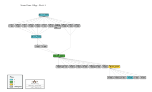
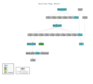
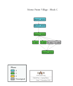
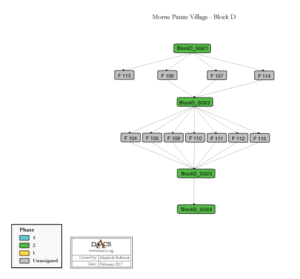
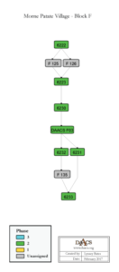
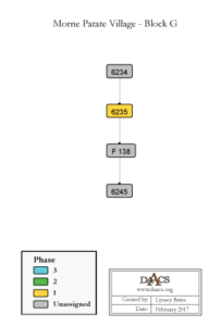
The Harris Matrix summarizes stratigraphic relationships among excavated contexts and groups of contexts that DAACS staff has identified as part of the same stratigraphic group. Stratigraphic groups and contexts are represented as boxes, while lines connecting them represent temporal relationships implied by the site’s stratification, as recorded by the site’s excavators (Harris 1979). Stratigraphic groups, which represent multiple contexts, are identified on the diagram by numeric designations (e.g., SG01). Contexts that could not be assigned to stratigraphic groups are identified by their individual context, or FS, numbers (e.g. 6120, 6205, etc. ).
The varied deposits excavated as part of the Village complex, including three house areas (Blocks A, B, C, and D) and two standalone excavation units (Blocks F and G), made the assignment of intrasite stratigraphic groups problematic. For this reason, we present separate Harris Matrices for each excavation block. Twelve total stratigraphic groups were assigned for three blocks: Block A SG01, SG02, SG03, SG04; Block B SG01, SG02, SG03, SG04; Block C SG01, SG02, SG03, SG04; Block D SG01, SG02, SG03, SG04. In general, the four stratigraphic groups within each excavation block were as follows: SG01 is a combination of topsoil and plowzone; SG02 is a buried A horizon; SG03 is a second buried A horizon; SG04 is B horizon. However, the sediment descriptions for these stratigraphic groups do not correlate across excavation blocks and thus the stratigraphic groups are recorded separately. The remaining contexts are identified by their individual feature or context numbers (e.g., 5400 or F046).
Boxes with color fill represent contexts and stratigraphic groups with ceramic assemblages large enough to be included in the DAACS seriation of the Village area as a whole (see Chronology). Seriation-based phase assignments are denoted by different colors to facilitate evaluation of the agreement between the stratigraphic and seriation chronologies. These phase assignments thus reflect an intrasite analysis, unlike the stratigraphic group assignments. Grey boxes represent contexts that were not included in the seriation because of small ceramic samples.
See Morne Patate Village Chronology for stratigraphic and phase information. For a printable version, download the PDFs: Block A Harris Matrix; Block B Harris Matrix; Block C Harris Matrix; Block D Harris Matrix; Block F Harris Matrix; Block G Harris Matrix.
These Harris Matrices are based on data on stratigraphic relationships recorded among contexts in the DAACS database. It was drawn with the ArchEd application. See http://www.ads.tuwien.ac.at/arched/index.html.

PDF of Morne Patate Village for Enslaved Laborers site plan with excavated features labeled, compiled by DAACS using maps provided by Mark Hauser, Principal Investigator.
PDF of Morne Patate Village for Enslaved Laborers site plan with excavated units labeled, compiled by DAACS using maps provided by Mark Hauser, Principal Investigator.
PDF of Morne Patate Village for Enslaved Laborers site plan with excavated features and units labeled, compiled by DAACS using maps provided by Mark Hauser, Principal Investigator.
Morne Patate Vilage for Enslaved Laborers site map shapefiles. Compiled by DAACS using maps and GIS data provided by Mark Hauser, Principal Investigator.
Bates, Lynsey , Jillian E. Galle , and Khadene K. Harris
2017 Testing Hypotheses of Carved Disc Usage: A Comparative Analysis of the Assemblage from Morne Patate, Dominica Presented at the 2017 Meeting of The International Association of Caribbean Archaeology. St. Croix, USVI.
Bates, Lynsey , Jillian E. Galle , and Fraser D. Neiman
2020 Building an Archaeological Chronology for Morne Patate, Building an Archaeological Chronology for Morne Patate In Archaeology in Dominica: Everyday Ecologies and Economics at Morne Patate. Eds. Mark W. Hauser and Diane Wallman. 64-88.
Galle, Jillian E., and Lynsey Bates
2017 “Jouer sur du velours”: Archaeological Evidence of Gaming on Sites of Slavery in the Caribbean and United States Paper presented at the Annual Meeting of the Society for American Archaeology,
Harris, Edward C.
1979 Principles of Archaeological Stratigraphy. Academic Press, London, England.
Harris, Khadene K.
2020 Morne Patate House Yards, 1750-1900: An Overview, Morne Patate House Yards, 1750-1900: An Overview In Archaeology in Dominica: Everyday Ecologies and Economics at Morne Patate. Eds. Mark W. Hauser and Diane Wallman. 88-111.
Hauser, Mark W.
2021 Mapping Water on Dominica: Environment and Enslavement under Colonialism Culture, Place and Nature University of Washington Press, Seattle.
Hauser, Mark W.
2020a Archaeological Survey of Colonial Dominica., Archaeological Survey of Colonial Dominica. Report on file at The Department of Anthropology, Northwestern University: Evanston, IL.
Hauser, Mark W., and Dianne Wallman
2020 Archaeology in Dominica: Everyday Ecologies and Economics at Morne Patate, Archaeology in Dominica: Everyday Ecologies and Economics at Morne Patate University of Florida Press: Gainesville, FL.
Hauser, Mark W.
2020 Everyday Economies and Ecologies of Plantation Life, Everyday Economies and Ecologies of Plantation Life In Archaeology in Dominica: Everyday Ecologies and Economics at Morne Patate. Eds. Mark W. Hauser and Diane Wallman. 1-31.
Murphy, Tessa , and Mark W. Hauser
2020 Dominica as an Evolving Landscape: Evidence of Changing Social, Political, and Economic Organization in the Eighteenth Century, Dominica as an Evolving Landscape: Evidence of Changing Social, Political, and Economic Organization in the Eighteenth Century In Archaeology in Dominica: Everyday Ecologies and Economics at Morne Patate. Eds. Mark W. Hauser and Diane Wallman. 31-48.
Wallman, Dianne , and Sarah Oas
2020 The Environmental Archaeology of Subsistence and the Socioecological Landscape at Morne Patate, The Environmental Archaeology of Subsistence and the Socioecological Landscape at Morne Patate In Archaeology in Dominica: Everyday Ecologies and Economics at Morne Patate. Eds. Mark W. Hauser and Diane Wallman. 153-168.