
| Location: | Utopia, James City County, VA, United States |
|---|---|
| Occupation Dates: | First and second quarter 18th-century. Phasing and mean ceramic dates can be found on the Chronology page. |
| Excavator(s): | Dr. Garrett Fesler. |
| Dates excavated: | 1994-1996. |

Overview
Utopia II Sitemap
Four successive generations of African and African-American slaves occupied the Utopia Quarter (44JC32) for almost exactly a century, between the 1670s and 1770s at roughly 20- to 30-year intervals. From an archaeological perspective Utopia consists of four discrete sites that happened to be situated at the same location. The focus here is on the second generation of inhabitants, otherwise known as Period 2 at Utopia when James Bray II owned the property between 1700 and 1725 and built a compound of slave quarters at the site. Bray II succeeded Thomas Pettus Jr. who first established the site at Utopia in the 1670s by building a large quartering house for his enslaved African and English indentured servant fieldworkers. In the 1730s, Bray II’s son and grandson built another group of quarters at Utopia for their enslaved workers. Lewis Burwell IV used the same site to construct quarters for his enslaved Africans in the 1740s and 1750s (Fesler 2004a).
The James River Institute for Archaeology, Inc. (JRIA) excavated Utopia II in the spring and summer of 1995. The site is located within the residential and recreational community of Kingsmill on the James, near the town of Williamsburg, Virginia, on property owned by Anheuser Busch, Inc. Because of the site’s ideal location on a high terrace overlooking the James River, Busch made plans to build townhouses on the property, thus providing the impetus to conduct an archaeological salvage excavation prior to development. As part of its mandate to preserve and study the historical resources on its property, Busch fully funded the excavation of Utopia II, and provided JRIA archaeologists ample time to excavate the entire site.
Documentary Evidence
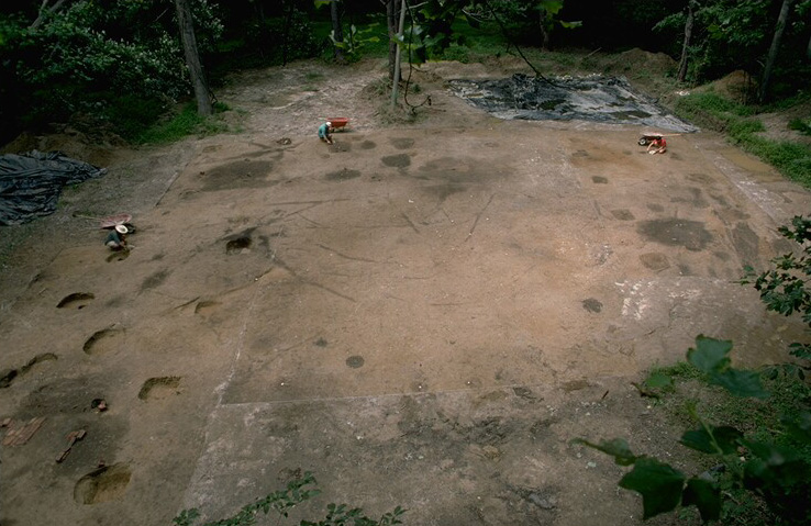
Photo of Utopia II, facing north
The original owner of Utopia, Thomas Pettus Jr., died unexpectedly in 1690 and within the year his widow, Mourning Pettus, had remarried James Bray II. After a decade of legal wrangling, Bray acquired formal ownership of the 1,280-acre Littletown/Utopia plantation in 1700 (Virginia Magazine of History and Biography 1938; Fesler 2000b). Archaeological evidence indicates that all of the buildings at the Utopia Quarter had been destroyed by fire by 1700 (Kelso 1984: 74, 79; Fesler 2000a: 49-51). Between 1700 and 1710 Bray reestablished a compound of slave quarters at Utopia, only a few dozen paces north of the original cottage.
Shortly before he died in November 1725, Bray II finalized his will, and his estate was probated in January 1726 (Bray 1725; Stephenson 1963). At the time of the probate, Bray owned 70 adult slaves, more than seven enslaved children, and an unknown number of indentured servants working on two large plantations, the 1,280 acre Littletown/Utopia plantation and the 2,220-acre Rockahock plantation located roughly 20 miles north and west of Williamsburg. More than 50 enslaved adults and children worked at Rockahock, distributed among six separate quarters.
Table 1: List of Slaves Owned by James Bray II, 1725
| Quartering Area | Adult Female Slaves | Adult Male Slaves | Overseer or Foreman | Horses | Other Livestock |
|---|---|---|---|---|---|
| Littletown | 7 | 45 | |||
| Debb’s | 13 | 11 | Forewoman | 48 | |
| Jacko’s | Foreman | 144 | |||
| Rogers’ | 3 | 3 | Overseer | 4 | 53 |
| Bridges | 10 | 3 | Overseer | 57 | |
| Dubblerum’s | 3 | 3 | Foreman | 2 | 36 |
| Nero’s | 3 | 2 | Foreman | 16 | |
| New Kent | 8 | 3 | 1 | 37 | |
| Rockahock* | 3 | 2 | 55 | ||
| Totals | 43 | 27 | 14 | 216 |
* Rockahock Quarter is just one of six quarters located on the larger Rockahock plantation.
Within the boundaries of his Littletown/Utopia plantation, Bray maintained an additional 24 adult slaves and four children at his home base at Littletown and at the two nearby field quarters managed by a slave foreman Jacko, and a forewoman Debb. The Utopia site functioned as either Debb’s or Jacko’s Quarter. The inventory does not indicate how Bray apportioned his slaves between Littletown, Debbs, and Jackos quarters, perhaps a sign that there was some amount of fluidity between the three venues and people moved about frequently depending upon staffing needs. Of the 24 adult slaves Bray kept close to him at these three quarters, the sex ratio almost reached parity—13 women and 11 men. Given the demographic snapshot of Bray’s slaves in 1725, women and men seemed to have worked at the same tasks and in the case of Debb a woman assumed the role of authority figure.
Table 2: Enslaved Africans at Littletown/Utopia
| Women | Men | Girls | Boys | Total |
|---|---|---|---|---|
| Moll | Sam | Lucy | Spring | |
| Dye | Jack | Martin | ||
| Janny | Caesar | Daniel | ||
| Batty | Tom | |||
| Flora | Jupiter | |||
| Doll | Jacko | |||
| Nanny | May | |||
| Hope | Orson | |||
| Debb | Mark | |||
| Brinee | Augor | |||
| Sandy | Juno | |||
| Judy | ||||
| Pegg | ||||
| 13 | 11 | 1 | 3 | 28 |
Excavation history, procedure, and methods
When William Kelso first excavated a portion of the Utopia site in the 1970s, he uncovered and excavated a 12 ft. by 16 ft. post-in-ground building (KM307). At the time, Kelso interpreted KM307 as an outbuilding in use during Period 1. However, as JRIA archaeologists opened up more of the site in 1995, it became apparent that KM307 was an outbuilding associated with the Period 2 occupation of the site.
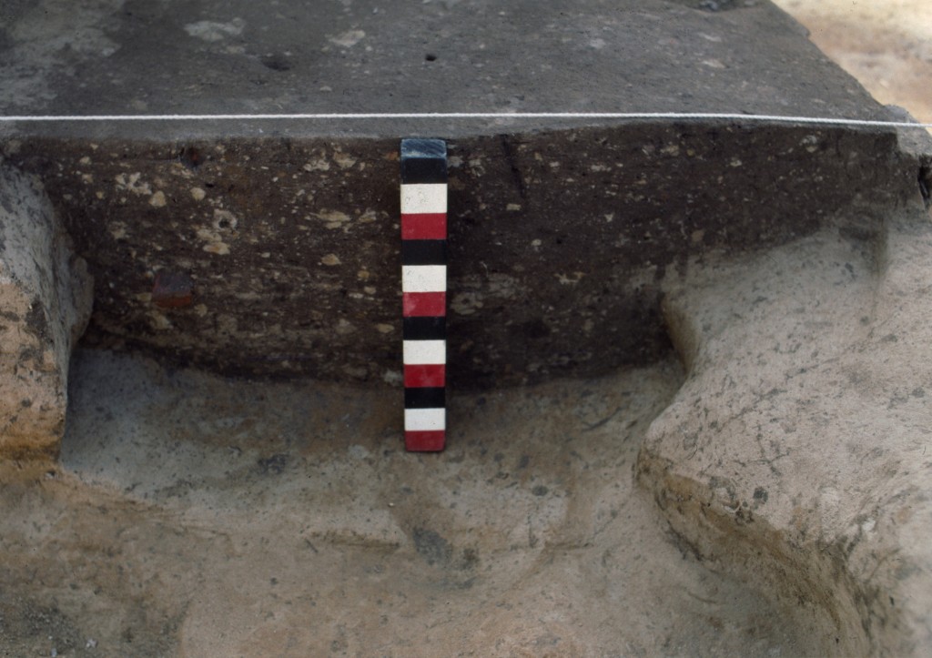
Because of disturbances in the topsoil across the surface of Period 2 Utopia (in part inadvertently caused during the 1970s excavation of Period 1), the topsoil and plowzone was mechanically removed from overtop the site. Archaeologists used flat shovels and trowels to scrape down the site and expose and define the features. A plan map of the site was generated at a scale of ¼”=1 ft. and each feature received a context number. Trowels were used to excavate the features and all soil was sifted through ¼” hardware cloth. All features were bisected at least once and a profile and plan was drawn at a 1”=1 ft. scale. Some of the more complex subfloor pits were bisected several times. One-hundred percent of the soil from all subfloor pits was saved and processed through a soil flotation system. All postmold fill was saved and floated, whereas five liters of each posthole was floated. All other features were sampled and those samples were floated as well. Heavy and light fraction generated by the flotation machine were sorted by hand with the aid of a magnifying glass and incorporated into the artifact collection from the site.
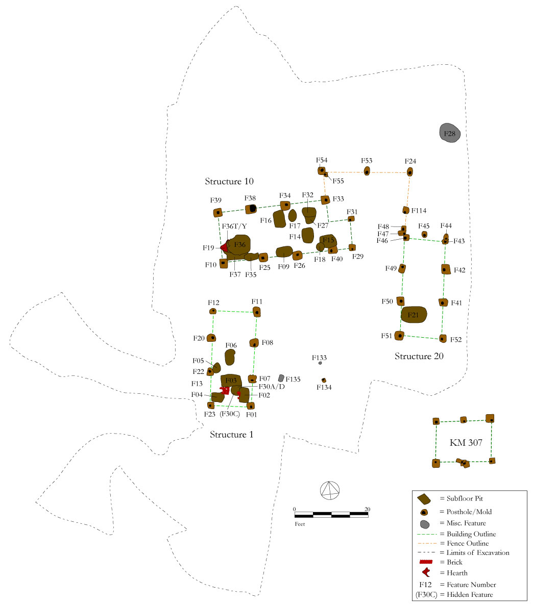
The archaeological components related to Utopia II consisted of 31 features or macro-features. The macro-features included four post-in-ground structures, and a post-and-rail fence connecting two of the structures. The majority of individual features—19 of them—pertained to subfloor pits. All of the features were excavated in their entirety and produced nearly 30,000 artifacts.
Table 3: Period 2 Utopia Features
| Type of Feature | N | JRAI Field Numbers | Description |
|---|---|---|---|
| Structures | 4 | FE1, FE10, FE20, KM307 | Three dwellings and one outbuilding |
| Hall Subfloor pits | 9 | FE2, FE3, FE4, FE21, FE30, FE35, FE36, FE36T, FE37 | Subfloor pits fronting gable-end fireplaces in the hall |
| Parlor Subfloor pits | 10 | FE5, FE6, FE9, FE14, FE15, FE16, FE17, FE18, FE27, FE32 | Subfloor pits located in the parlor of structures |
| Hearth Base | 1 | FE13 | Dry-laid hearth in Structure 1 |
| Hearth Debris | 1 | FE19 | Brick and debris area in Structure 10 |
| Circular Pit | 1 | FE28 | Circular pit located north from Structure 20 |
| Cooking Pit | 1 | FE133 | Possible cooking pit in courtyard |
| Fence Enclosure | 1 | FE114 | Fence posts connecting Structure 10 and 20 |
| Pit or Post | 1 | FE29 | Indeterminate pit feature |
| Small Pits | 2 | FE134 and FE135 | Possible small pit features |
| Total | 31 |
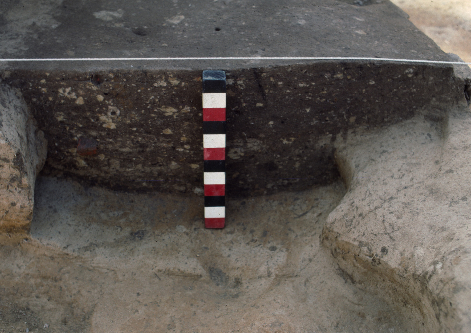
The carpenters framed the four Period 2 buildings on posts, as per the most popular form of vernacular architecture of the period (Carson et al. 1981). Structures 1, 10, and 20 served as housing units, while Structure KM307 was most likely used as an outbuilding. Structures 1 and 20 both measured 12 ft. by 28 ft. in size. Structure 1 contained six subfloor pits, most of them positioned at one end of the building around a dry-laid brick hearth. The only interior feature inside Structure 20 was a large subfloor pit positioned in the southwest corner of the building, most likely fronting a fireplace. Structure 10 was the largest of the three housing units with dimensions of 16 ft. by 32 ft. with an attached shed. Structure 10 had a large subfloor pit complex fronting a fireplace on its west end, while the east half of the building contained eight pits arrayed along the walls of the room. The fourth structure, a 12 ft. by 16 ft. outbuilding (KM307) with no internal features, was located to the south of Structure 20.
The buildings were positioned to form an open area courtyard in the center. A post-and-rail fence tied Structure 10 to Structure 20 to form a small enclosure. Archaeologists excavated a hearth-related feature in Structure 1 and in Structure 10, and five pit features of varying sizes in the yard. Feature 28 was a large circular pit approximately 6 ft. in diameter that appeared to be the top of a well shaft. However, excavation proved that it was only 4 ft. deep, perhaps evidence of an aborted well. FE133 was located in the courtyard outside Structure 1 and it most likely served as a small cooking pit.
Excavation history, procedure, and methods
When William Kelso first excavated a portion of the Utopia site in the 1970s, he uncovered and excavated a 12 ft. by 16 ft. post-in-ground building (KM307). At the time, Kelso interpreted KM307 as an outbuilding in use during Period 1. However, as JRIA archaeologists opened up more of the site in 1995, it became apparent that KM307 was an outbuilding associated with the Period 2 occupation of the site.
Because of disturbances in the topsoil across the surface of Period 2 Utopia (in part inadvertently caused during the 1970s excavation of Period 1), the topsoil and plowzone was mechanically removed from overtop the site. Archaeologists used flat shovels and trowels to scrape down the site and expose and define the features. A plan map of the site was generated at a scale of ¼”=1 ft. and each feature received a context number. Trowels were used to excavate the features and all soil was sifted through ¼” hardware cloth. All features were bisected at least once and a profile and plan was drawn at a 1”=1 ft. scale. Some of the more complex subfloor pits were bisected several times. One-hundred percent of the soil from all subfloor pits was saved and processed through a soil flotation system. All postmold fill was saved and floated, whereas five liters of each posthole was floated. All other features were sampled and those samples were floated as well. Heavy and light fraction generated by the flotation machine were sorted by hand with the aid of a magnifying glass and incorporated into the artifact collection from the site.
The archaeological components related to Utopia II consisted of 31 features or macro-features. The macro-features included four post-in-ground structures, and a post-and-rail fence connecting two of the structures. The majority of individual features—19 of them—pertained to subfloor pits. All of the features were excavated in their entirety and produced nearly 30,000 artifacts.
Table 3: Period 2 Utopia Features
| Type of Feature | N | JRAI Field Numbers | Description |
|---|---|---|---|
| Structures | 4 | FE1, FE10, FE20, KM307 | Three dwellings and one outbuilding |
| Hall Subfloor pits | 9 | FE2, FE3, FE4, FE21, FE30, FE35, FE36, FE36T, FE37 | Subfloor pits fronting gable-end fireplaces in the hall |
| Parlor Subfloor pits | 10 | FE5, FE6, FE9, FE14, FE15, FE16, FE17, FE18, FE27, FE32 | Subfloor pits located in the parlor of structures |
| Hearth Base | 1 | FE13 | Dry-laid hearth in Structure 1 |
| Hearth Debris | 1 | FE19 | Brick and debris area in Structure 10 |
| Circular Pit | 1 | FE28 | Circular pit located north from Structure 20 |
| Cooking Pit | 1 | FE133 | Possible cooking pit in courtyard |
| Fence Enclosure | 1 | FE114 | Fence posts connecting Structure 10 and 20 |
| Pit or Post | 1 | FE29 | Indeterminate pit feature |
| Small Pits | 2 | FE134 and FE135 | Possible small pit features |
| Total | 31 |
The carpenters framed the four Period 2 buildings on posts, as per the most popular form of vernacular architecture of the period (Carson et al. 1981). Structures 1, 10, and 20 served as housing units, while Structure KM307 was most likely used as an outbuilding. Structures 1 and 20 both measured 12 ft. by 28 ft. in size. Structure 1 contained six subfloor pits, most of them positioned at one end of the building around a dry-laid brick hearth. The only interior feature inside Structure 20 was a large subfloor pit positioned in the southwest corner of the building, most likely fronting a fireplace. Structure 10 was the largest of the three housing units with dimensions of 16 ft. by 32 ft. with an attached shed. Structure 10 had a large subfloor pit complex fronting a fireplace on its west end, while the east half of the building contained eight pits arrayed along the walls of the room. The fourth structure, a 12 ft. by 16 ft. outbuilding (KM307) with no internal features, was located to the south of Structure 20.
The buildings were positioned to form an open area courtyard in the center. A post-and-rail fence tied Structure 10 to Structure 20 to form a small enclosure. Archaeologists excavated a hearth-related feature in Structure 1 and in Structure 10, and five pit features of varying sizes in the yard. Feature 28 was a large circular pit approximately 6 ft. in diameter that appeared to be the top of a well shaft. However, excavation proved that it was only 4 ft. deep, perhaps evidence of an aborted well. FE133 was located in the courtyard outside Structure 1 and it most likely served as a small cooking pit.
Summary of research and analysis
A number of archaeologists have analyzed all or portions of the Utopia Quarter site since the early 1970s. Garrett Fesler has produced the majority of research on all occupations at the Utopia Quarter site including several technical reports, publications, and a dissertation (Fesler 1997, 2000a, 2000b, 2001, 2004a, 2004b). Other archaeologists who have worked with the Utopia data include William Kelso, Patricia Samford, and Donna and Clifford Boyd.
Fesler:
In addition to technical publications, Fesler has written a dissertation that examined the composition and growth of households at the Utopia Quarter, and compared these findings with the wider Chesapeake region. The three types of archaeological data used to test and explore household and family formation processes at the site include artifact assemblages, subfloor pit morphology, and architecture and use of space (Fesler 2004a). Preliminary findings suggest that house size at Utopia grew smaller over time. Fesler inferred that as the 18th century progressed, the site’s enslaved residents lived in housing units that could better accommodate smaller family groups. The gradual reduction in the number of subfloor pits within the dwellings at the three Utopia sites also suggests a changing group dynamic as family members began to share storage spaces. Fesler argued that consumption patterns at Utopia, as measured by the number of artifacts generated by each living unit, also indicated the steady growth of family groups. Overall, Fesler illustrated with multiple lines of evidence the likely evolution of what he considers the “slave family” (2004a).
In a separate article, Fesler analyzed gender relations at Utopia II (2004b), hypothesizing that three possible living arrangements—single-sex barracks, a village compound, or family households—may have been implemented at Utopia II. Fesler used architectural, spatial, and artifactual data to conclude that Utopia II most closely resembled an indigenous West or Central African compound, possibly with living arrangements segregated by gender (2004b). Fesler has also written several technical reports that detail the excavation of Utopia (2000b; 2004a) and a study of the spatial organization of the site by examining artifact distribution and soil chemistry patterns (Fesler 2001).
Kelso:
William Kelso led the first excavations at Utopia in the 1970s and described his findings in a technical report (1976). Kelso’s research was eventually published in his book,Kingsmill Plantations 1619-1800: Archaeology of Country Life in Colonial Virginia (1984b).
Samford:
Patricia Samford has used data from the subfloor pits at the site during the course of writing a dissertation (2000) and for an article (1999). Samford argued that some of the subfloor pits at Utopia may have been used as religious shrines, as well as for the more pedestrian use as storage for food and personal belongings.
Donna Boyd and Clifford Boyd:
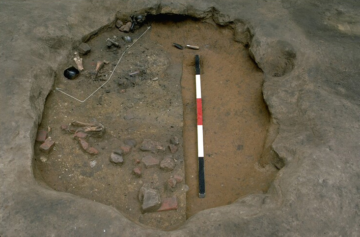
Donna and Clifford Boyd conducted the osteological analysis of the skeletal remains from twenty-five human burials at Utopia (1996). Despite poor preservation in the thirteen burials containing skeletal remains, the Boyds were able to determine that the general health of the burial population, based on the dentition patterns of the adults, was relatively poor.
Garrett Fesler
James River Institute for Archaeology (JRIA)
May 2005
Things you need to know about Utopia II before you use the data:
- Utopia II consists primarily of features cut into the subsoil.
- 100% of subfloor pit feature sediment floated.
- Plowzone was removed and discarded without sampling.
- Measurements are in feet and tenths of feet.
Feature Numbers
DAACS staff has assigned feature numbers using the original excavation records. Feature numbers assigned by DAACS have a F-prefix, which precedes the number (i.e. F01 equals Feature 1). In the case of Utopia II, many of the DAACS-assigned feature numbers are the same context numbers assigned by the original excavators.
Excavated contexts that belong to the same depositional basin (e.g. a posthole and postmold or the layers in a single pit) have been assigned a single feature number. In addition, single contexts have been given feature numbers when the original field records indicate that the excavators recognized a context’s spatial distinctiveness from surrounding contexts.
Feature Numbers
Feature groups are sets of features whose spatial arrangements indicate they were part of a single structure (e.g. structural postholes, subfloor pits, and hearth) or landscape element (e.g. postholes that comprise a fenceline). Feature Groups assigned by DAACS have a FG-prefix, which precedes the number (i.e. FG01 equals Feature Group 1).
| Feature | Feature Type | Contexts |
|---|---|---|
| F01 | Posthole | 001A, 001B |
| F02 | Pit, subfloor(< 28 sq.ft) | 002A, 002B, 002C, 002D, 002, 002/3 |
| F03 | Pit, subfloor(< 28 sq.ft) | 003, 003A, 003B, 003C |
| F04 | Pit, subfloor(< 28 sq.ft) | 004C, 004A, 004B, 004D, 004E, 004F, 004G, 004 |
| F05 | Pit, subfloor(< 28 sq.ft) | 005A |
| F06 | Pit, subfloor(< 28 sq.ft) | 006A |
| F07 | Posthole | 001C, 001D |
| F08 | Posthole | 001E, 001F |
| F11 | Posthole | 001G, 001H |
| F12 | Posthole | 001J, 001K |
| F13 | Hearth, possible | 013A |
| F20 | Posthole | 001L, 001M |
| F22 | Posthole | 001N, 001P |
| F23 | Posthole | 001R, 001S |
| F30A/D | Pit, subfloor(< 28 sq.ft) | 030A, 030B, 030D |
| F30C | Pit, subfloor(< 28 sq.ft) | 030C |
| Feature | Feature Type | Contexts |
|---|---|---|
| F09 | Pit, subfloor(< 28 sq.ft) | 009A1, 009A2, 009A3, 009A4, 009A5, 009A6, 009A7, 009A8, 009A9, 009A10, 009A11, 009B1, 009B2, 009B3, 009B4, 009B5, 009B6, 009C1, 009C2, 009D, 009, 009A |
| F10 | Posthole | 010A, 010B |
| F14 | Pit, subfloor(< 28 sq.ft) | 014, 014A, 014B, 014C, 014D, 014E |
| F15 | Pit, subfloor(< 28 sq.ft) | 015A1, 015A2, 015A3, 015A4, 015A5, 015A6, 015A7, 015A8, 015A9, 015A10, 015A11, 015A12, 015A13, 015, 015A |
| F16 | Pit, subfloor(< 28 sq.ft) | 016, 016A, 016B, 016C |
| F17 | Pit, subfloor(< 28 sq.ft) | 017A1, 017A2, 017A3, 017A4, 017A5, 017A6, 017A7, 017B1, 017B2, 017B3, 017C1, 017C2 |
| F18 | Pit, subfloor(< 28 sq.ft) | 018A1, 018A2, 018A3, 018, 018A, 018A4 |
| F19 | Hearth, possible | 019A, 019B, 019C, 019D, 019E |
| F25 | Posthole | 010C, 010D |
| F26 | Posthole | 010E, 010F |
| F27 | Pit, subfloor(< 28 sq.ft) | 027, 027A, 027B, 027C |
| F29 | Posthole | 010J, 010K |
| F31 | Posthole | 010M, 010L |
| F32 | Pit, subfloor(< 28 sq.ft) | 032A |
| F33 | Posthole | 010N, 010P, 010AC |
| F34 | Posthole | 010R, 010S |
| F35 | Pit, subfloor(< 28 sq.ft) | 035A |
| F36 | Pit, subfloor(< 28 sq.ft) | 012A, 036A, 036B, 036C, 036D, 036E, 036F, 036G, 036H, 036I, 036J, 036K, 036L, 036L1, 036L2, 036M, 036N, 036P, 036R, 036S, 036W, 036X, 036Z |
| F36T/Y | Pit, subfloor(< 28 sq.ft) | 036T, 036Y |
| F37 | Pit, subfloor(< 28 sq.ft) | 037B, 037C, 037D, 038A |
| F37A | Basin formed by post-depositional settling | 037A |
| F38 | Posthole | 010T, 010W |
| F39 | Posthole | 010X, 010Z |
| F40 | Posthole | 010G, 010H |
| Feature | Feature Type | Contexts |
|---|---|---|
| F21 | Pit, subfloor(< 28 sq.ft) | 021, 021K, 021A, 021B, 021C, 021C2, 021D, 021E, 021F, 021G, 021H, 021J |
| F41 | Posthole | 020D, 020C |
| F42 | Posthole | 020E, 020F |
| F43 | Posthole | 020H, 020G |
| F44 | Posthole | 020J, 020K |
| F45 | Posthole | 020L, 020M |
| F46 | Posthole | 020T, 020W |
| F47 | Posthole | 020S, 020R |
| F49 | Posthole | 020X, 020Z |
| F50 | Posthole | 020AA, 020AB |
| F51 | Posthole | 020AC, 020AD |
| F52 | Posthole | 020B, 020A |
| Feature | Feature Type | Contexts |
|---|---|---|
| F055 | Posthole | 114I, 114J |
| F055 | Posthole | 114I, 114J |
| F114 | Posthole | 114A |
| F24 | Posthole | 114C, 114D |
| F48 | Posthole | 020P |
| F53 | Posthole | 114F, 114E |
| F54 | Posthole | 114G, 114H |
| Feature | Feature Type | Contexts |
|---|---|---|
| F133 | Pit, unidentified | 133A |
| F134 | Posthole, possible | 134A, 134B |
| F135 | Pit, unidentified | 135A |
| F28 | Pit, unidentified | 028D, 028A, 028B, 028C |
DAACS Seriation Method
This page summarizes a frequency-seriation based chronology for the Utopia II site that was developed by DAACS (see Neiman, Galle, and Wheeler 2003 for technical details). At Utopia II, DAACS seriated ceramic assemblages, with more than five sherds, from excavated features. This made it possible to assign larger samples of artifacts to phases than if the analysis had been conducted at the level of stratigraphic groups and individual contexts, where sample size are much smaller.
The seriation chronology is derived from a correspondence analysis of MCD-type frequencies in the eight features that met the sample size criterion. Seriated assemblages were assigned to phases. Phases are groups of assemblages that have similar correspondence-analysis scores and are therefore inferred to be broadly contemporary. Phases assigned by DAACS have a P-prefix that precedes the phase number (e.g. P01 equals Phase 1).
The stratigraphic relationships among stratigraphic groups and unassigned contexts are summarized in the Harris Matrix for the site. Phase assignments from the seriation are shown on the Harris Matrix in color, facilitating comparison of the seriation chronology and the stratigraphic chronology of the site.
Utopia II Site Phases
Based on the correspondence analysis, DAACS divided the occupation of Utopia II into two temporal phases. The first phase is comprised of assemblages from subfloor pits beneath both Structures 1 and 10 (F02, F03, F14, F09, F32). The second phase was in turn divided into two subphases, based on apparently significant (synchronic) variation between the assemblages from the pits (F36 and F04) under Structures 1 and 10 and the single subfloor pit (F21) under Structure 20. The causes of this variation remain to be determined. Could Structure 20 be an overseer’s or driver’s house?
Both phases have a TPQ of 1720, based on sherds of Buckley coarse earthenware and William Rogers stoneware. The latter is coded as “American Stoneware” in DAACS. Mean ceramic dates for both phases place them in the middle of the 18th century. Note that in computing the MCDs quoted below, “American Stoneware” was assigned a manufacturing range of 1720 to 1750, which are the dates of the William Rogers pottery at Yorktown. The MCDs seem anomalously late. This may be explained by the fact that most of the MCD types found on the site have manufacturing spans that encompass nearly all of the 18th century.
Binford pipestem dates from the four features with samples of twenty or more stems range from 1722 to 1742. In this case, the pipestem dates are probably more accurate than the MCDs.
A Seriation Chronology for the Utopia II Site
The following table presents a seriation chronology for the Utopia II Site. We use the indefinite article to signify that it is not the only chronology possible, nor even the best one possible.
| Phase | MCD | TPQ | TPQp90 | Total Count |
|---|---|---|---|---|
| P01 | 1754 | 1720 | 1700 | 85 |
| P02a | 1763 | 1720 | 1700 | 71 |
| P02b | 1762 | 1700 | 1700 | 16 |
Utopia II Harris Matrix
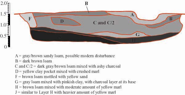
The Harris Matrix summarizes stratigraphic relationships among excavated contexts and groups of contexts that DAACS staff has identified as part of the same stratigraphic group. Stratigraphic groups and contexts are represented as boxes, while lines connecting them represent temporal relationships implied by the site’s stratification, as recorded by the site’s excavators (Harris 1979).
Stratigraphic groups, which represent multiple contexts, are identified on the diagram by their numeric designations (e.g. SG10) followed by the original excavator’s descriptions of them (e.g. “occupation zone”). Contexts that could not be assigned to stratigraphic groups are identified by their individual context numbers (e.g. 622A).
Boxes with color fill represent contexts and stratigraphic groups with ceramic assemblages large enough to be included in the DAACS seriation of the site (see Chronology). Their seriation-based phase assignments are denoted by different colors to facilitate evaluation of the agreement between the stratigraphic and seriation chronologies. Grey boxes represent contexts that were not included in the seriation because of small ceramic samples.
See Utopia II Chronology for stratigraphic and phase information.
This Harris Matrix is based on data on stratigraphic relationships recorded among contexts in the DAACS database. It was drawn with the ArchEd application. See http://www.ads.tuwien.ac.at/arched/index.html.
For a printable version, download the Harris Matrix [121.39 KB PDF].


Composite excavator’s plan, compiled by DAACS from original field drawings.
Composite excavator’s plan, compiled by DAACS from original field drawings, showing cut-away drawings of intrusive features.
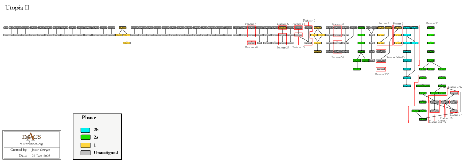
Composite excavator’s plan, compiled by DAACS from original field drawings, showing all three Utopia phases with their relative locations to one another.
Virginia Magazine of History and Biography.
1938 Deed Releasing Littletown/Utopia to James Bray, XLVI(1):52-55.
Boyd, C. Clifford, Jr., and Donna C. Boyd
1996 An Osteological Analysis of 18th Century Human Skeletal Remains from Utopia I (44JC32), Kingsmill on the James, James City County, Virginia. Manuscript on file, James River Institute for Archaeology, Inc., Williamsburg, Virginia.
Bray, James , II
1725 James Bray (II) Will and Inventory. Manuscript on file, Colonial Williamsburg Foundation Rockefeller Library, Williamsburg, Virginia.
Carson, Cary , William M. Kelso , Dell Upton , and Gary Wheeler Stone
1981 Impermanent Architecture in the Southern American Colonies. In Winterthur Portfolio 16:135-196.
Fesler, Garrett
2001 Back to Utopia: An Interim Report on Renewed Archaeological Excavations at the Utopia Quarter, Field Seasons 1993-1996. Results of Shovel Testing. Volume V. James River Institute for Archaeology, Inc., Williamsburg, Virginia.
Fesler, Garrett
2004a From Houses to Homes: An Archaeological Case Study of Household Formation at the Utopia Slave Quarter, ca. 1675 to 1775. Ph.D. dissertation, Department of Anthropology, University of Virginia, Charlottesville, Virginia.
Fesler, Garrett
2004b Living Arrangements among Enslaved Women and Men at an Early Eighteenth-Century Virginia Quartering Site., Engendering African American Archaeology: A Southern Perspective In Engendering African American Archaeology: A Southern Perspective, edited by Jillian E. Galle and Amy L. Young. University of Tennessee Press, Knoxville, Tennessee.
Fesler, Garrett
1997 Phase I Archaeological Survey of 270 Acres at the Former Camp Wallace Army Training Base at Kingsmill on the James, James City County, Virginia. Report submitted to Busch Properties, Inc. James River Institute for Archaeology, Inc., Williamsburg, Virginia.
Fesler, Garrett
2000a Back to Utopia: An Interim Report on Renewed Archaeological Excavations at the Utopia Quarter, Field Seasons 1993-1996. Period 1 Occupation, ca. 1675-1700. Volume I. James River Institute for Archaeology, Inc., Williamsburg, Virginia.
Fesler, Garrett
2000b Back to Utopia: An Interim Report on Renewed Archaeological Excavations at the Utopia Quarter, Field Seasons 1993-1996. Period 2 Occupation, ca. 1700-1730. Volume II. James River Institute for Archaeology, Inc., Williamsburg, Virginia.
Harris, Edward C.
1979 Principles of Archaeological Stratigraphy. Academic Press, London, England.
Kelso, William M.
1976 Historical Archaeology at Kingsmill: The 1974 Season. Virginia Research Center for Archaeology, Yorktown, Virginia.
Kelso, William M.
1984b Kingsmill Plantations, 1619-1800: Archaeology of Country Life in Colonial Virginia. Academic Press, Inc., Orlando, Florida.
Neiman, Fraser D., Jillian E. Galle , and Derek Wheeler
2003 Chronological Inference and DAACS. Unpublished paper presented at the annual meeting of the Society for Historical Archaeology, Providence, Rhode Island. On file at the Department of Archaeology, Thomas Jefferson Foundation, Charlottesville, Virginia.
Samford, Patricia
1999 Strong is the Bond of Kinship: West African Ancestor Shrines and Subfloor Pits on African-American Quarters., Historical Archaeology, Identity Formation, and the Interpretation of Ethnicity In Historical Archaeology, Identity Formation, and the Interpretation of Ethnicity, edited by Maria Franklin and Garrett Fesler, pp. 71-92. Colonial Williamsburg Foundation Research Publications. Dietz Press, Richmond, Virginia.
Samford, Patricia
2000 Power Runs in Many Channels: Subfloor Pits and West African-Based Spiritual Traditions in Colonial Virginia. Ph.D. dissertation, Department of Anthropology, University of North Carolina, Chapel Hill, North Carolina.
Stephenson, Mary A.
1963 A Record of the Bray Family, 1658-ca.1800. Ms., Colonial Williamsburg Foundation Rockefeller Library, Williamsburg, Virginia.