| Location: | Westmoreland County, Virginia |
|---|---|
| Occupation Dates: | 18th, 19th, and 20th centuries |
| Excavator(s): | Arthur A. Shurcliff (1930); Morley J. Williams (1934); Fraser D. Neiman and Virginia Research Center for Archaeology (1976); Douglas Sanford and University of Mary Washington field school (1993-1999); John Milner Associates (1998); Data Investigations (2015-2018) |
| Dates excavated: | 1930, 1934; 1976; 1993 - 1999; 1998 |
Overview
The West Yard is part of Stratford Hall Plantation, the historic estate of the Lee family located along the Potomac River in Westmoreland County, Virginia. The Lees occupied the estate from the late 1730s until it was sold in 1822. After passing through several hands, Stratford Hall Plantation was bought by the Robert E. Lee Memorial Foundation in 1929. When the Foundation incorporated in Virginia in the 1970s, the name was changed to the Robert E. Lee Memorial Association.
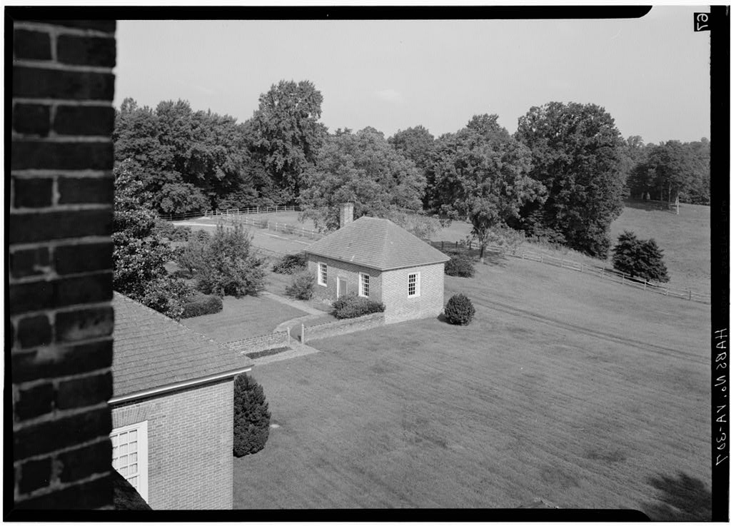
The West Yard is an area measuring approximately 215-x-215 feet located immediately to the west of the estate’s Great House. The exact historical use(s) of the West Yard area during the Lee period and throughout the nineteenth century are largely undocumented in the written record. The lack of written records for this space influenced 1930s restoration efforts, with the area left relatively unattended as a grassy field and orchard.
In 1942 The Robert E. Lee Memorial Foundation engaged New York landscape architects Innocenti and Webel to develop plans for the West Yard. The interpretive plan envisioned the West Yard as a service area, bordered by brick walls to the north and south, with a grassy drive as a center axis. However, World War II introduced challenges to these efforts and only a portion of the recommendations were enacted. In 1963 the geometric flower bed outlines were finally installed although the beds were uniformly planted with annuals of a single color (History: Virginia Gardens 2016). Vegetable garden plots were installed in 1981 by Stratford’s horticulturalist Ron Wade to complete the development of this area. Finally, in the mid-1990s, Stratford’s Master Gardener Jacqui Shoaf redesigned the flower and vegetable beds. Brick walking paths were added to the geometric flowerbeds to facilitate access to the plantings.
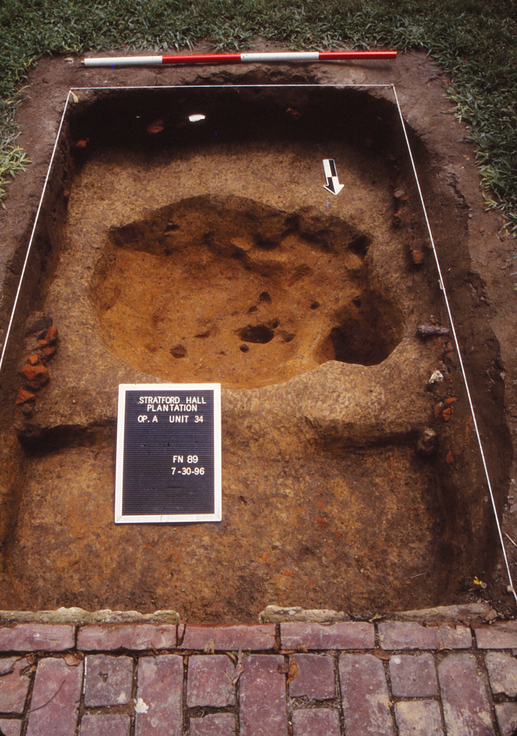
Between 1930 and 2000, four separate archaeological campaigns sought information on the various uses of the West Yard. These investigations found that restoration activities had largely transformed the area into a plowzone site although there was subsurface evidence of intact deposits. Notable findings include the robbed remains of a brick foundation as well as a large rectangular pit feature. A fifth archaeological season in the West Yard is being conducted by DATA Investigations to address some spatial gaps in the previous work. Archaeological data recovered from this research between 2015-2017 is also included in DAACS.
Documentary Evidence
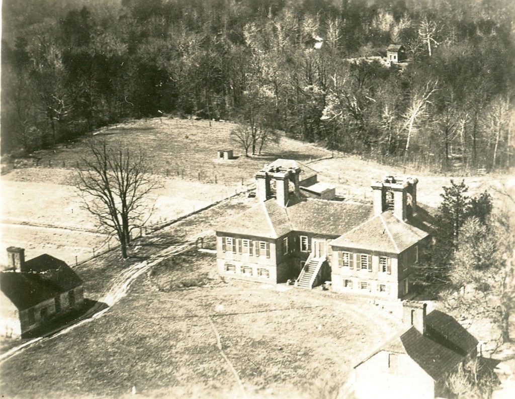
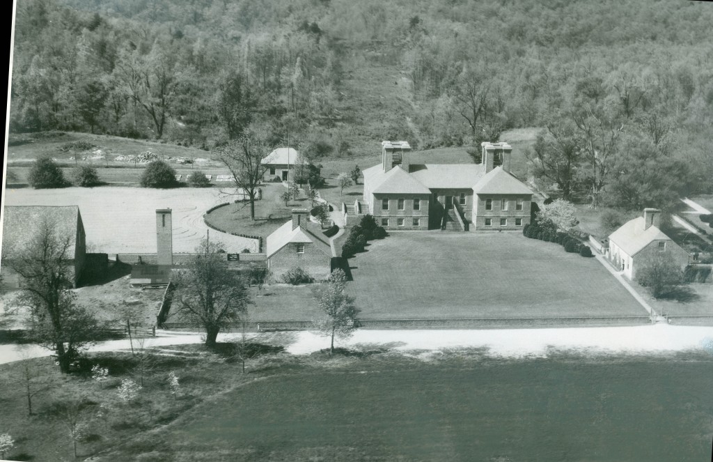
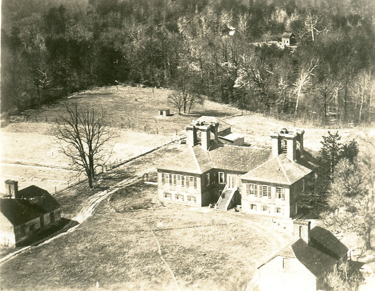
Figure 1: West Yard, Stratford Hall aerial photograph, c. 1936. Courtesy of the Robert E. Lee Memorial Association.
Thomas Lee purchased the acreage that is now Stratford Hall in 1717. Construction of the Great House began in 1737 or 1738. The 1801 Mutual Assurance Policy and 1805 Insurance Plat provide an overview of the substantial structures associated with the Stratford Hall Plantation, but do not offer much in the way of detailed information about the activities of the West Yard area. To date, no detailed landscape documents illustrating the area known as the West Yard have been found. Archival evidence indicates that the West Yard area was plowed in the 1930s and 40s, particularly in 1936 prior to an orchard planting, and then again in 1946 in preparation for a more formal restoration effort, including the Innocenti flower bed arrangement (Figures 1 and 2). The 1946 plowing comprised a significant landscape modification that left a clear archaeological signature throughout the central two-thirds of the West Yard.
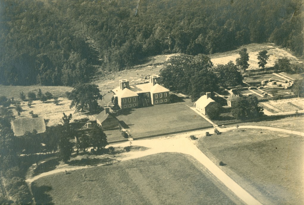
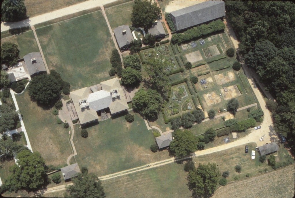
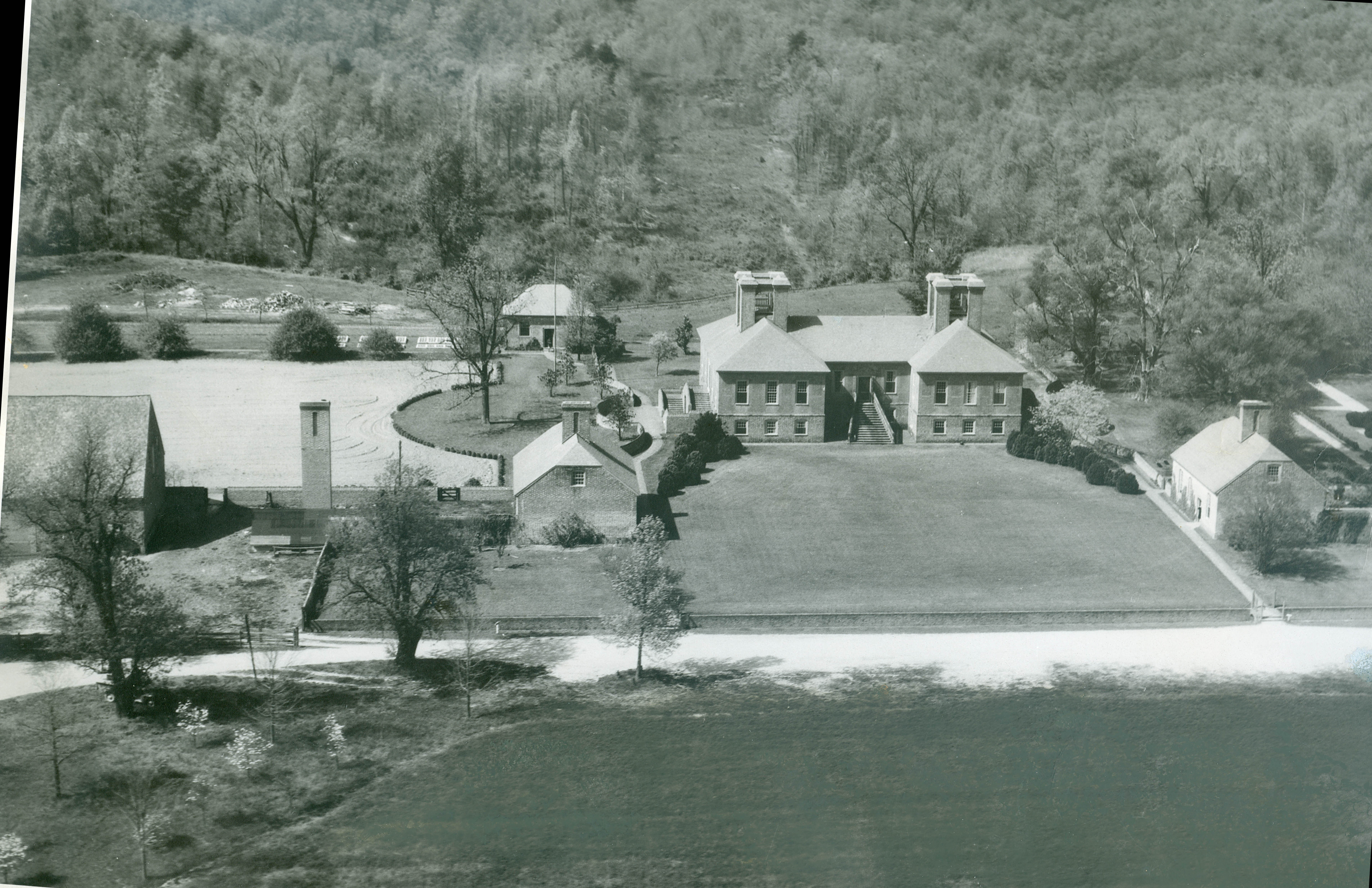
Figure 2: West Yard, Stratford Hall aerial photograph, c. 1945. Courtesy of the Robert E. Lee Memorial Association.
Plowing did not reach the West Yard’s northern, southern, and eastern ends, however, nor the area east of the large walnut tree on line with the center axis and west doorway of the Great House. A sketch by Ethel Armes (n.d.) shows the West Yard as a “Plowed field at present” and indicates that plowing in the 1930s may have extended to the area’s northern perimeter, although restoration activities during and after the 1940s may have obscured evidence of this plowing. Much of the West Yard remained a grassy orchard even after the installation of the geometric flower beds in the 1960s and kitchen garden beds in the 1980s.
Excavation History, Procedure, and Methods
1930s Arthur Shurcliff and Morley Williams
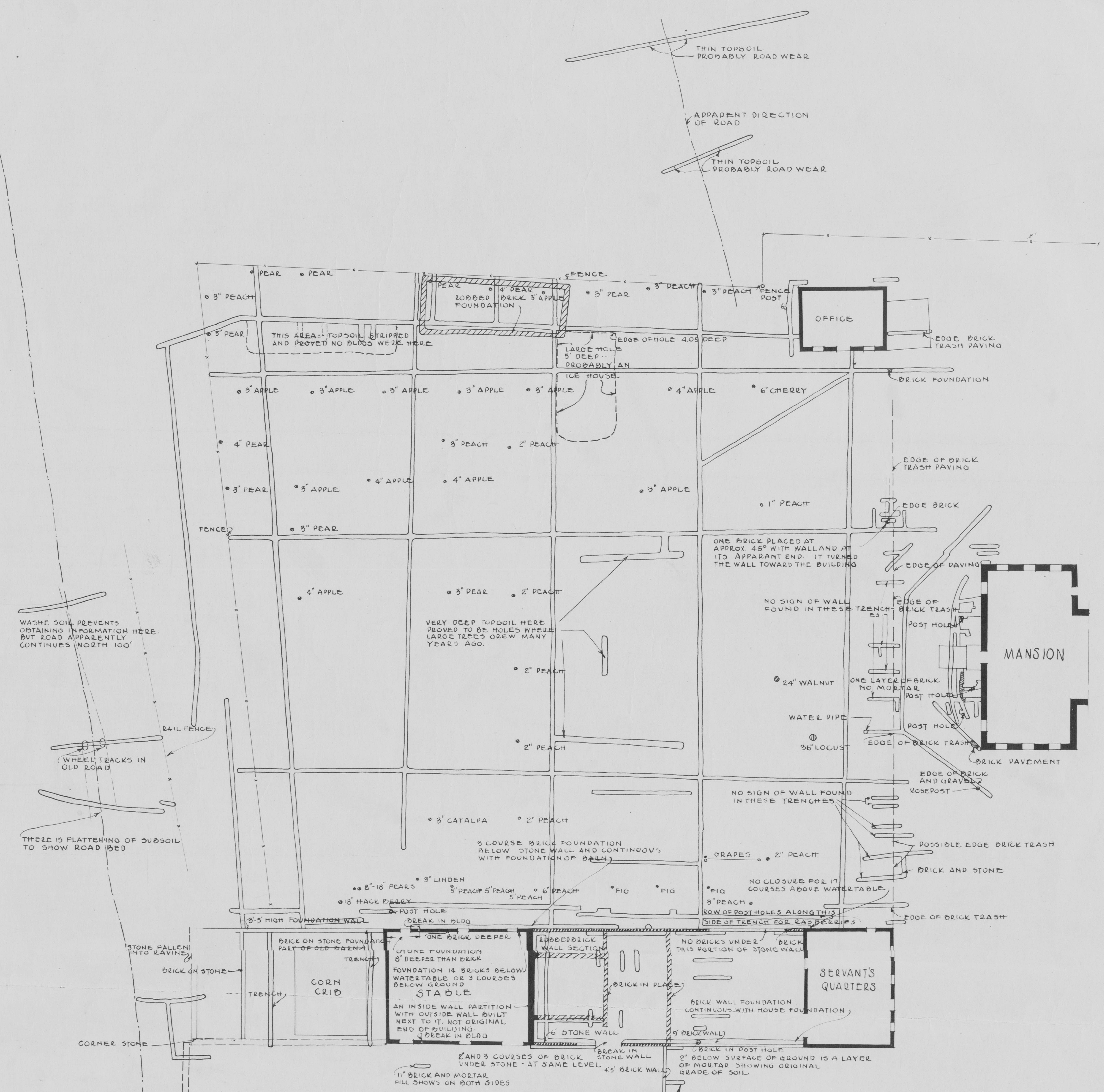
Figure 3: Plan of 1934 Research Excavation, courtesy Robert E. Lee Memorial Association.
Arthur Shurcliff, a landscape architect, undertook a field study of the brickwork both above and below ground in walls, pavements, and structures at Stratford. These investigations entailed removing brick and mortar samples deemed representative of walls and pavement (Shurcliff 1930). Shurcliff and his team also conducted excavations using trenching methods between July and September 1930 (Armes 1936:503).
From 1932 to 1934, Morley Williams, also a landscape architect, led trenching work in the eastern and western portions of the areas surrounding the Great House (Morley 1934). Approximately 20 trenches running north-south and east-west were dug at the edges of the area west of the Great House (Figure 3). More extensive trenching focused on the area immediately east of the Great House known as the East Garden.
Two notable discoveries from these excavations were: 1) subsurface evidence of a robbed brick foundation for a structure measuring approximately 50-x-20 feet; 2) a large (approximately 25-x-35 feet), deep rectangular pit (an early estimate suggested five feet). The robbed brick foundation was located along the north side of the West Yard, roughly in line with the Northwest Outbuilding. Once identified, the building was further delineated by way of additional cross trenches in and around the structure, and then by “aproning” of the robbed brick and mortar foundation, namely removing soils from around the structure in order to better see the masonry evidence (Sanford n.d.:Chapter 3, page 13). Investigators did not find any evidence that the structure had a chimney, either at one of its ends or in the middle. Although Shurcliff was searching for evidence of an orangery or greenhouse, investigators found no diagnostic evidence for the use of the building as a greenhouse (Shurcliff 1937).
Archaeological work of the 1930s also defined a large, approximately 25-x-35 feet, and deep (5 feet) rectangular pit, that was designated as an “icehouse.” Continued excavations in the 1970s and 1990s presented additional evidence that caused later researchers to revise this interpretation (see below).
Although the artifacts and contexts from the 1930s West Yard excavations are not available through DAACS, the excavation trenches have been georecitifed and placed on the DAACS ArcGIS map for Stratford Hall, which can be downloaded from the Maps and Images section of this site.
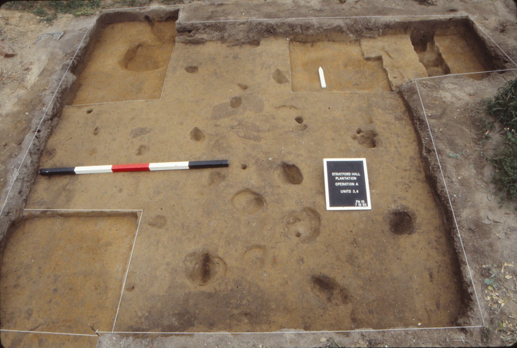
1976 Fraser Neiman and Virginia Research Center for Archaeology
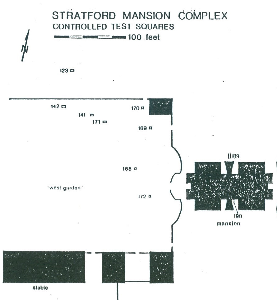
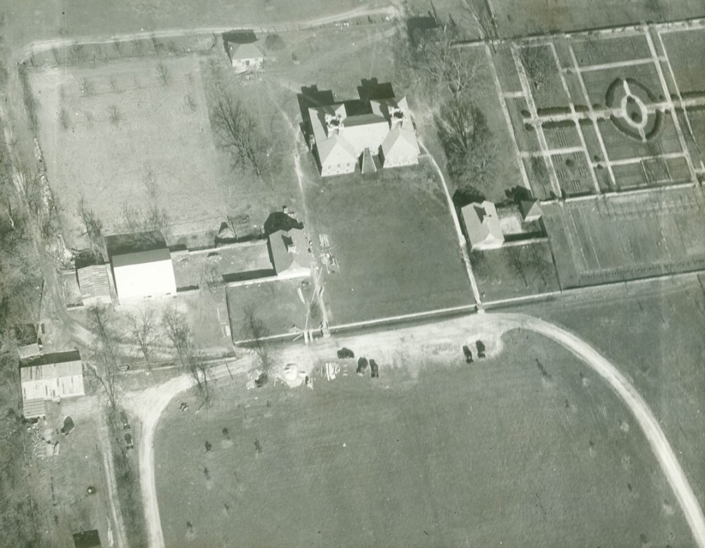
Figure 4: Plan view map of VRCA’s 1976 excavations.
In the Spring of 1976, the Virginia Research Center for Archaeology (VRCA) was contracted to conduct a survey of the entire Stratford Plantation to create a catalog of archaeological resources. Survey fieldwork was carried out in three phases. Phase I consisted of surface inspection of plowed fields at 15-to-20 foot intervals. Areas under vegetation, pasture, and woodland were subsurface tested with shovel test pits (STPs) roughly placed on 20-foot centers (Neiman 1979:36).
Phase II of the survey was designed to provide a more refined idea of the size, complexity, and date of the site tested in Phase I. An attempt was made to leave sealed archaeological contexts as intact as possible. Since the research project was to be focused on the colonial period, the seventeenth and eighteen century sites were prioritized (Neiman 1979:2). The context information from the Phase I and Phase II excavations have not been entered into DAACS.
Phase III focused on the area in the immediate vicinity of the Great House. The area was divided into 50-foot grid blocks oriented with the building axis of the Great House. The West Yard and the area east of the kitchen courtyard were tested with STPs dug exactly on 10-foot centers. Thus 25 holes were excavated at equal intervals within each 50-foot square. An attempt was made to record stratigraphy as it was encountered, although the size of the holes sometimes made this difficult (Neiman 1979:37). Investigations also consisted of larger test squares placed over features identified as areas of interest that seemed to be of special archaeological promise or in areas that showed evidence of intact dateable strata. Several larger test squares were also excavated in specific areas chosen from an inspection of the Shurcliff and Williams plans of the 1930s excavations, to determine the extent to which the colonial foundations noted there had been affected by these early excavations and the subsequent restoration.
Seven quadrats (Figure 4) were excavated in the area west of the house (Neiman 1979:43-46). These quadrats and the associated artifact data are available in DAACS. A 3-x-5 foot test square was placed across the west wall of a 18-x-50 foot robbed foundation discovered by Shurcliff and Williams in the north portion of the West Yard (VRCA142). Trenching in the 1930s destroyed the builders’ trenches in which the wall was laid, precluding the archaeological dating of the wall’s construction. However, the destruction rubble of shell, mortar, and brick were found to be intact.
A second 3-x-5 foot test unit (VRCA141) was placed near the east wall of the same building revealing a small colonial trash pit (2.5 feet in diameter) containing primarily oyster shell and animal bone (VRCA141C). The pit had been dug through a surviving old topsoil layer (VRCA141B). The intersection of two 1930s archaeology trenches was noted in the south and west portions of the square. Trenches in this location are not shown on the Shurcliff and Williams site plans, an indication that more archaeologically destructive trenching was carried out in the 1930s than was recorded.
A rectangular feature, 36-x-10 feet in plan and 5 feet in depth, appears on the Williams site plan not far from the 18-x-50 foot structure noted above. A label on the plan suggests it was an icehouse. A 3-x-5 foot test (VRCA171) was placed across its eastern edge, disclosing that, once the feature had been located during cross-trenching, that portion of it within the test square was completely emptied of its contents. The 1930s trench cut through a buried topsoil layer (VRCA171B), which unfortunately did not contain any dateable artifacts.
Four 3-x-3 foot controlled squares were also excavated in the West Yard, closer to the Great House on the western dependencies than those tests previously discussed. Three of these produced evidence for a compromised occupation layer (VRCA168A, VRCA172B, and VRCA169C) containing artifacts from the early-nineteenth century, for example cut nails and fragments of pearlware plates. One of the three near the Northwest Outbuilding contained a previous archaeology trench which had been dug 1.2 feet into subsoil (VRCA169B), suggesting that the explorations of the 1930s not only impacted occupation strata, but also sealed contexts below subsoil as well (i.e., postholes, robbed walls, ditches, etc.), if such features had the misfortune of being located in the path of one of many such trenches. A fourth 3-x-3 foot square was excavated 10 feet west of the Northwest Outbuilding. It revealed a jumble of layers (VRCA170A-J) of recent deposition, probably associated with the construction of cold frames in the vicinity under the direction of General Cheatham, director of Stratford Hall in the 1930s. Beneath them lay what is probably another unrecorded 1930s archaeology trench (VRCA170H).
1993-1999 Douglas Sanford and University of Mary Washington
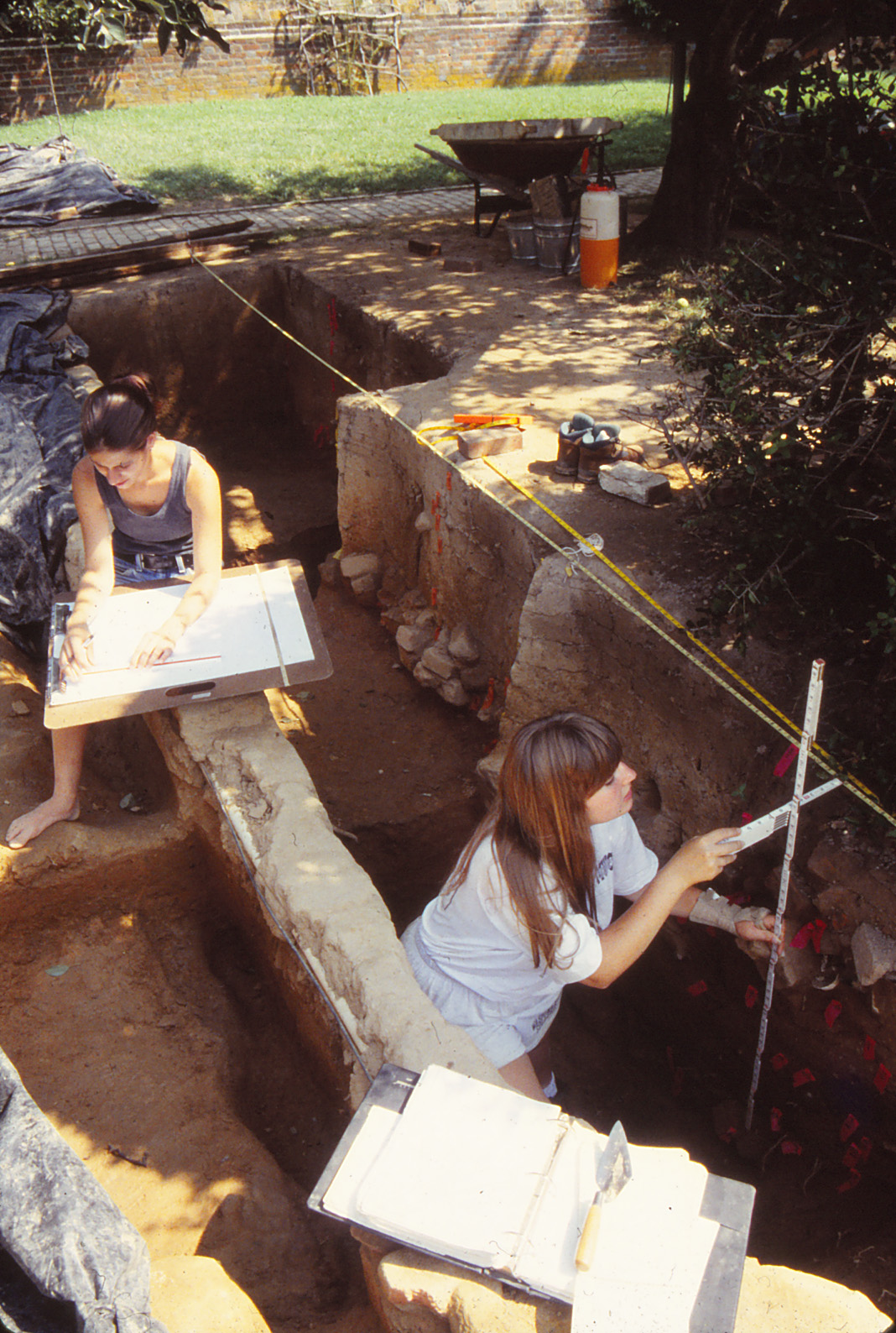
The University of Mary Washington conducted archaeological field schools at Stratford Hall for seven consecutive seasons between 1993 and 1999 under the direction of Dr. Douglas W. Sanford (Sanford n.d. Chapter 3; Sanford 1993, 1994, 1995, 1996, 1997; Smith, Andrews and Sanford 1998). Lacking detailed landscape documents at Stratford, archaeologists relied on a three-pronged field strategy for the West Yard. First, excavations targeted the locations and features of particular interest identified by either the archaeological testing of the 1930s or 1970s. Second, by applying knowledge of plantation organization and eighteenth-century landscape design from comparative historical and archaeological sources, staff members predicted the locations for specific design elements and landscape divisions or barriers. Third, given the objective of sampling the West Yard as a whole, but with larger units that would allow better observation of features and the spatial relations between them, archaeologists predominantly used ten foot squares as the basic excavation unit, and distributed these units across the operation area (A). The following paragraphs provide a summary of excavations grouped by areas of investigation. All of the information from field records and artifact data are available in DAACS.
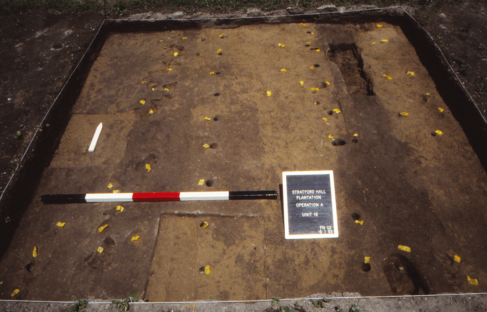
Figure 5: Unit 16, facing North, below topsoil – modern gardening features flagged. Image courtesy of University of Mary Washington.
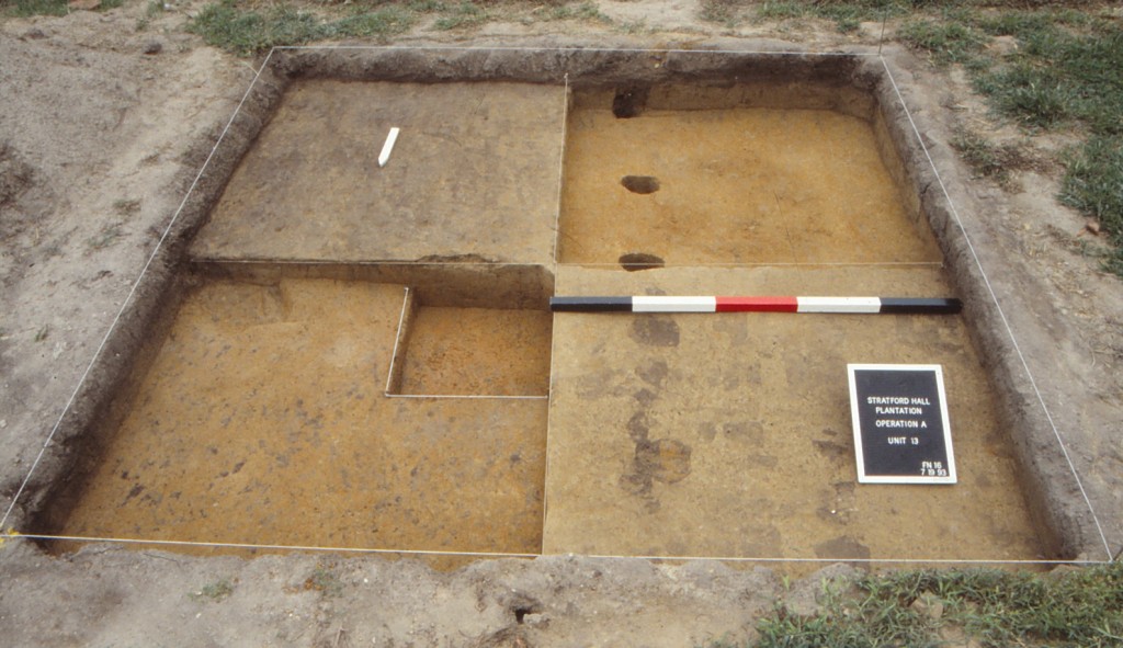
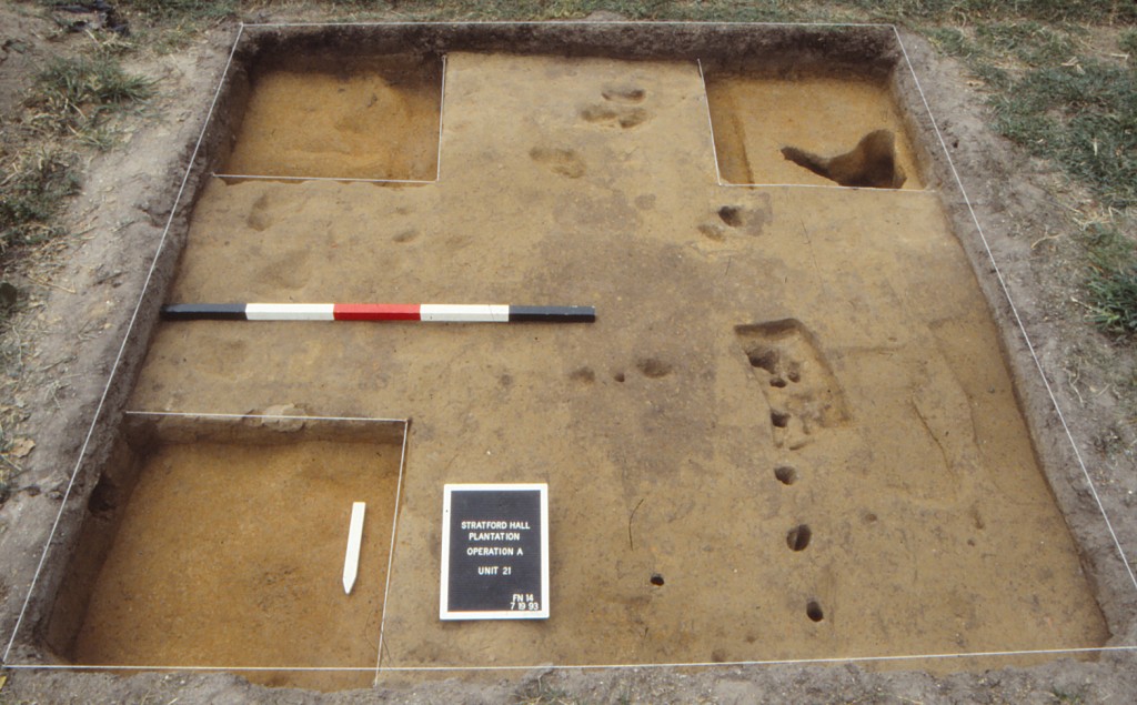
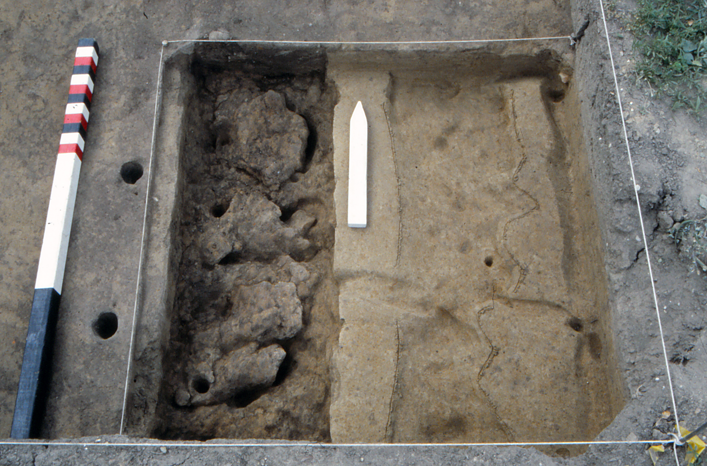
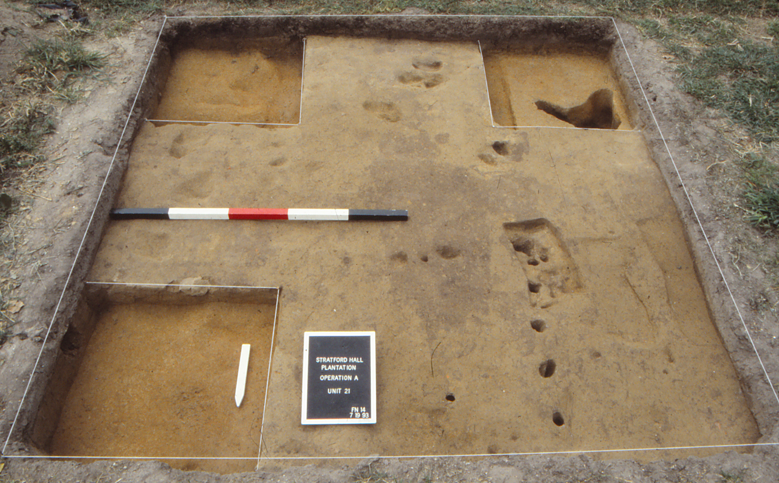
Kitchen Garden Beds (UMW Units 3, 4, 6, 7, 11, 13, 16, 21, 37, 39)
The large kitchen garden beds facilitated archaeology in this portion of the West Yard by acting as small plowed fields that enabled the excavation of several ten-foot squares within their boundaries (Figure 5). Excavations here generally revealed a consistent stratigraphic sequence (about one foot in depth), with the modern organic fill of the garden beds overlying the surviving portion of the 1940s plowzone, followed by one or two natural soil zones, including the orange clay subsoil (Sanford 1993:4-5, 1994:5-6). Modern gardening features, such as bean pole impressions, planting trenches, and spade divots, were identified, given proveniences, and excavated separately so that these recent intrusions and associated artifacts (e.g., plastic, modern terra cotta pottery, bottle glass, etc.) would not be confused with any features surviving from previous periods. Smaller test cuts were excavated within certain 10-x-10 foot units to investigate deposits. Many of these modern gardening features were entered as “unnumbered features” in DAACS.
Screening removed soils resulted in the regular recovery of artifacts other than those of the post-restoration era. Of particular interest were those of the Lee family period, which included ceramics, wine bottle glass, nails, window glass, and small brick fragments in roughly similar proportions. In other words, general domestic and architectural refuse had accumulated in the area, although not in high quantities and without significant concentrations, at least in the test units of the modern garden beds. Importantly, many of these artifacts dated from the late-eighteenth (post-1770) and early-nineteenth centuries, with little evidence for the first twenty to thirty years of the plantation’s occupation. The garden bed test units also uncovered small, but consistent amounts of Native American stone artifacts, mostly debitage (flakes) from tool production, but also a few projectile points of the Late Archaic to Early Woodland timeframe (3000 BC to 500 AD). The primary lithic material was quartz, although some quartzite occurred, as did red jasper, which is native to the Potomac River drainage.
Beyond the modern planting features associated with recent horticulture, few features were discovered in the West Yard’s western half. These features were limited to one rectangular planting hole, one tree planting hole, and a few, apparently random postholes or stake impressions. Given these sparse findings, archaeologists could not define or propose formal spatial divisions for this area.
Testing at the West Yard’s East and North Perimeters (UMW Unit 35)
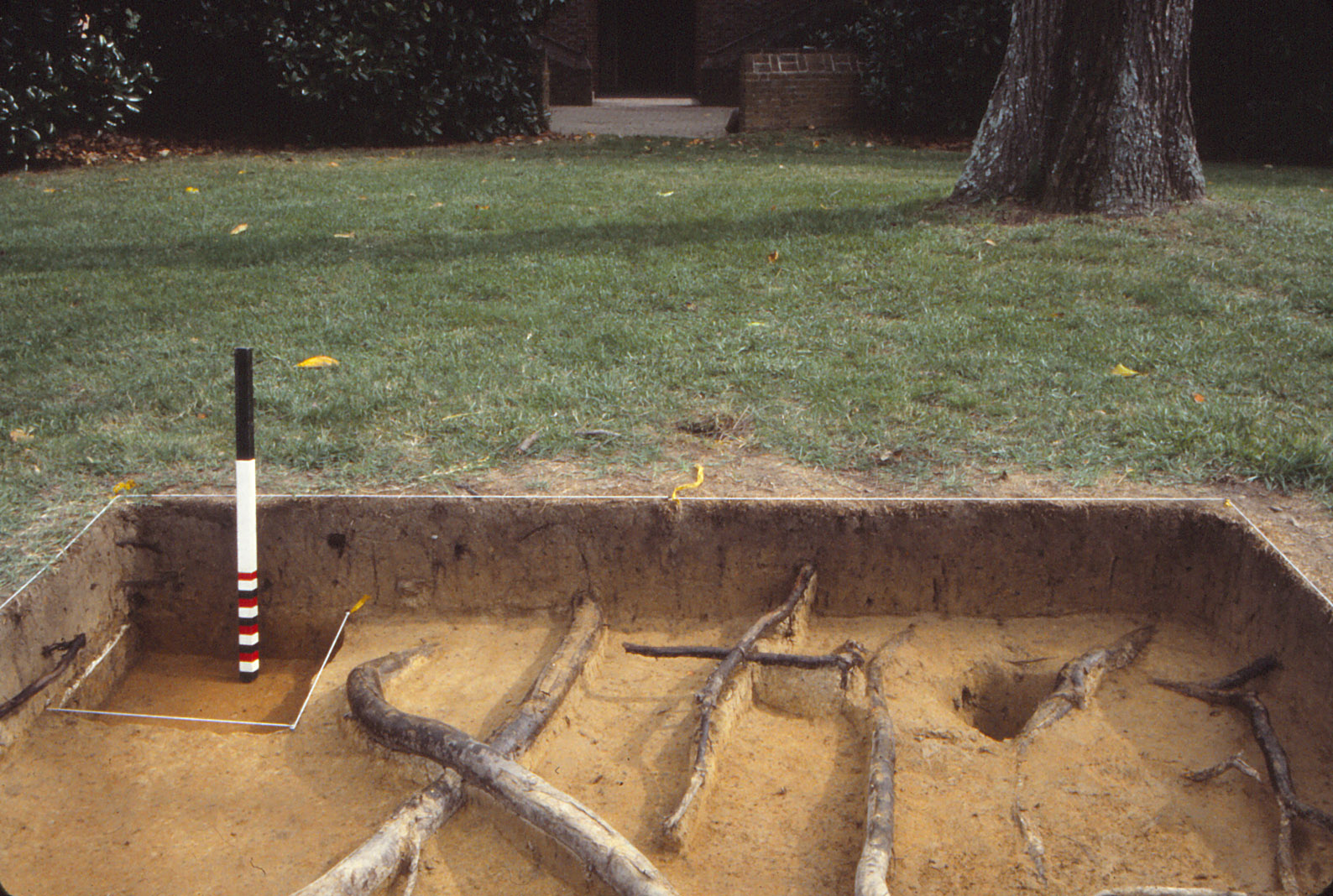
Figure 6: UMW Unit 35 east balk, facing east.
Placed in predictive fashion, UMW Unit 35 (Figure 6) rests on the extension of the Great House’s central (east-west) axis line in the area just west of a large English walnut tree (Sanford n.d. Chapter 3, pages 4-5; Sanford 1993:8-9). Here archaeologists sought indications of either a central walkway into the West Yard, or a landscape element or division that respected this potential design line. Instead, only limited evidence for Lee period features came to light. A dense artifact concentration dominates the upper portion of Unit 35 and contains a mixture of modern materials (those of the early-twentieth century and restoration era) and items from the nineteenth century. While the lack of landscape features was disappointing, the artifact assemblage within the higher strata forms a basis for looking at occupation of the Great House during the post-Lee ownerships at Stratford. A few artifacts of the eighteenth century and prehistoric era occur within the upper layers as well. Beneath these fills, archaeologists did uncover one posthole (F04), but this feature was not associated with dateable evidence and could originate from either the post-Lee period or the eighteenth century. Drawing on other possible associations, the posthole is similar to those found adjacent to the west steps of the Great House during the 1992 UMW testing, but the exact manner of their possible relation is not clear. Additionally, the posthole may form part of the north-south fence line/division scheme proposed to exist between the Northwest and Southwest Outbuildings based on evidence at the extant outbuilding and within the Innocenti bed test squares.
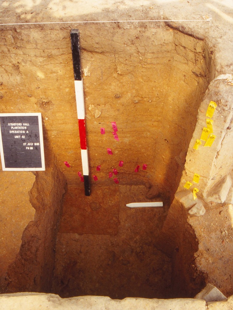
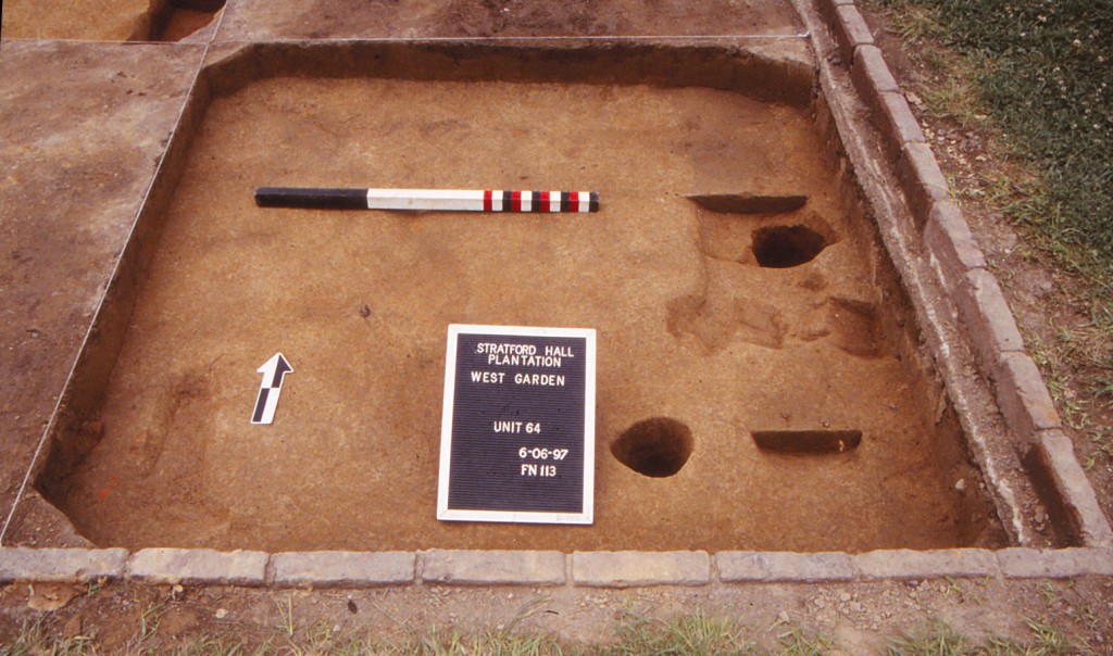
The Innocenti Beds (UMW Units 61, 62, 63, 64, 65, 66, 67, 68, 69, 70, 71)
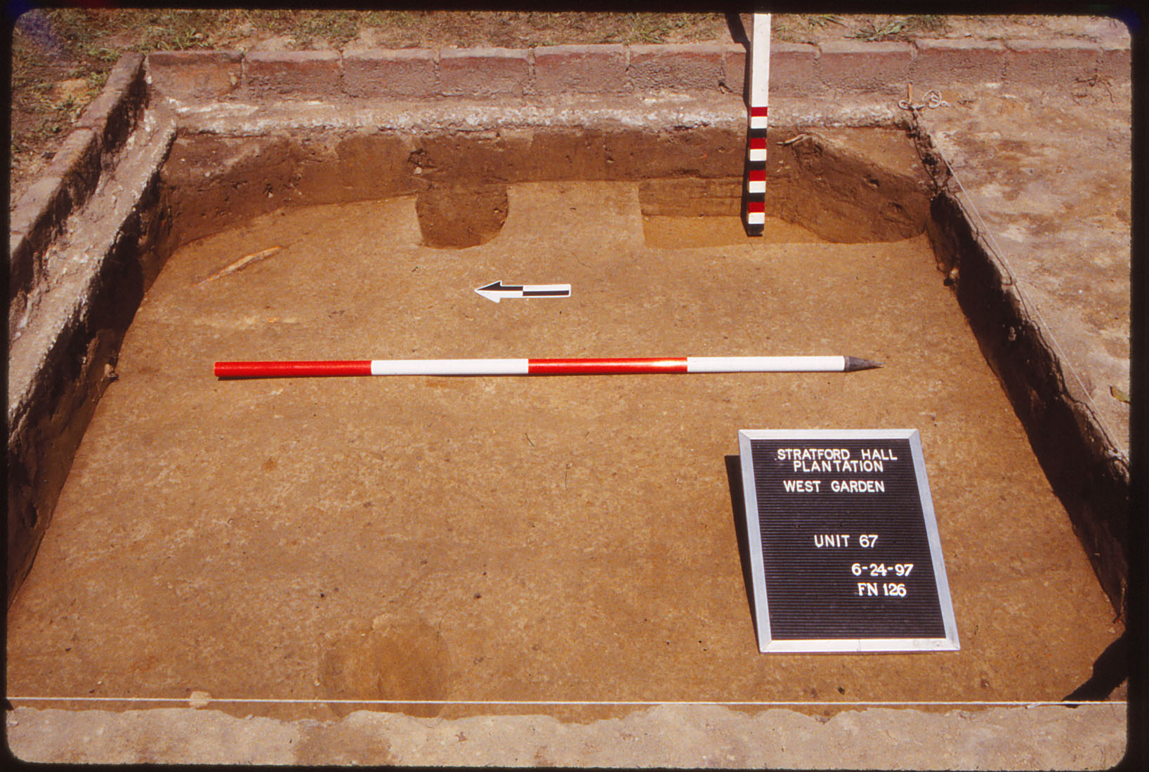
Figure 7: UMW Unit 67, Postholes, facing east.
Separated by the central, east-west grass walkway of the West Yard are two planting areas (of three beds each) known as the Innocenti flowerbeds. During the 1997 field school season, students and staff implemented a series of 11 six-foot test squares within the six curvilinear flower beds of this modern landscape arrangement (Sanford n.d.:Chapter 3, page 6; Sanford 1997:13; Smith, Andrews, and Sanford 1998). In this case, the purpose was to sample the area prior to the installation of brick walkways, a construction project that would destroy archaeological evidence. From an overall perspective, the eleven test squares supplied important support for the interpretation of the West Yard as a service yard by confirming that there was no evidence of formal landscaping. In general, the evidence from this area matched that recorded in the kitchen beds of the West Yard. The majority of recovered artifacts originated from the Lee period, although a consistent minority of materials dated to the post-Lee ownership era of the mid-nineteenth to early-twentieth century, and readily compare to similar artifacts found nearby in UMW Units 34 and 35.
Beneath the modern planting bed fill, archaeologists distinguished the modern plowzone discussed earlier, with this soil matrix containing most of the recovered artifacts. A few historic features existed beneath the plowzone, and those discovered towards the eastern end of the testing operation merit the most attention. In particular, a series of small postholes (F05, F06, F07, F08, and F35, F68, Figure 7) and a ditch (F67) backfilled in the mid-nineteenth century may further define the north-south barrier that once existed between the western sides of the Northwest and Southwest Outbuildings (see discussion below).
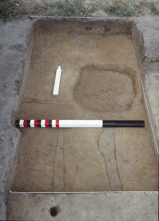
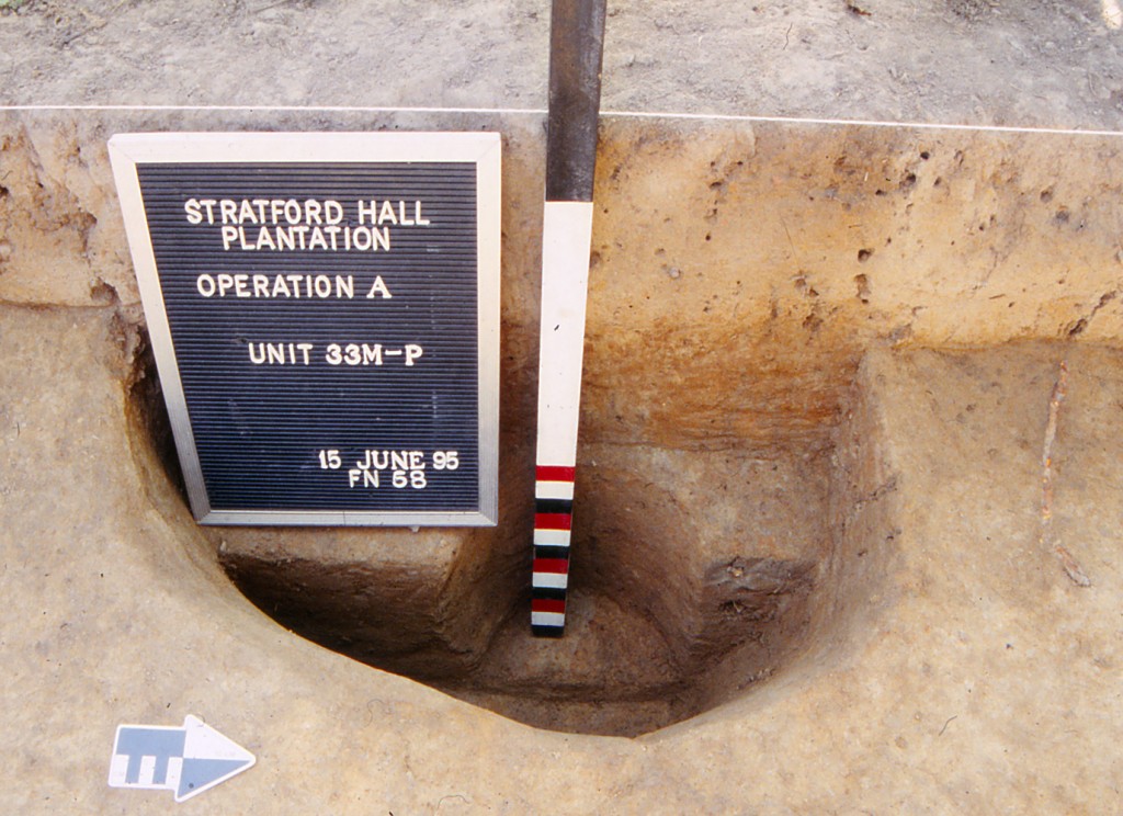
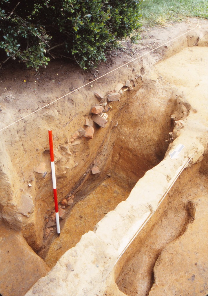
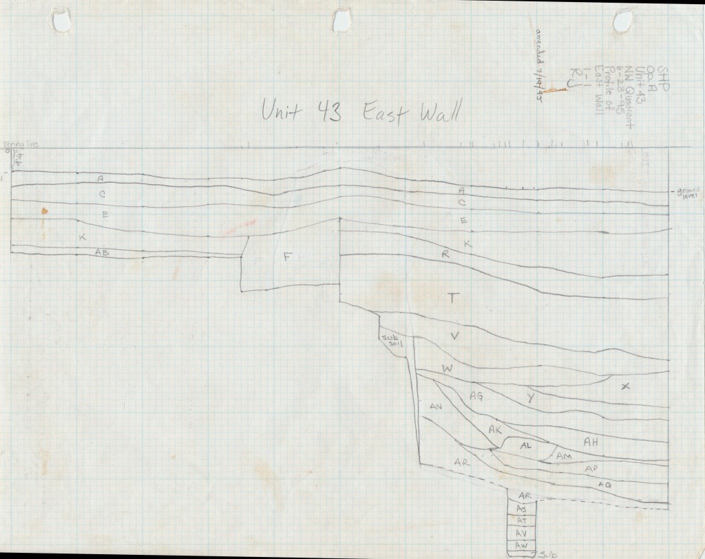
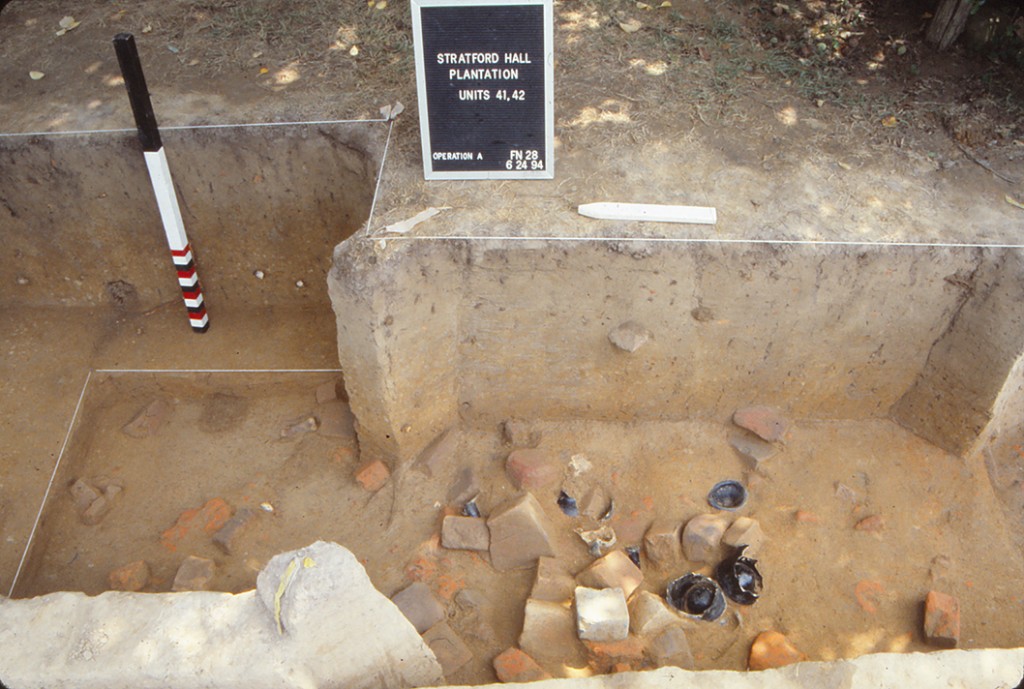
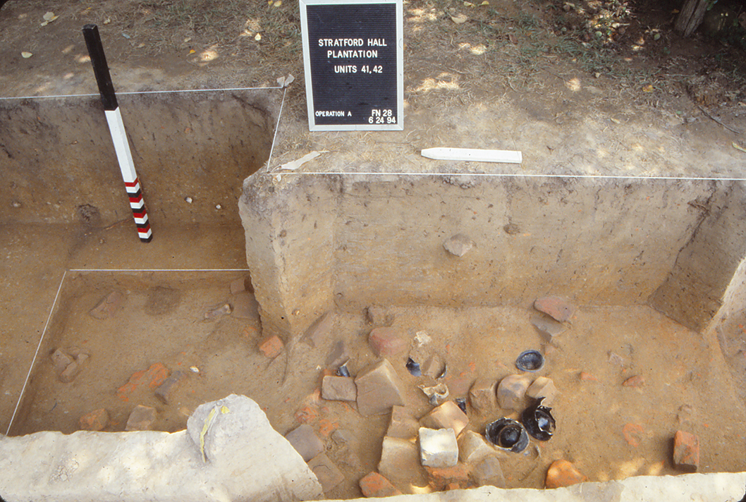
Feature 01 (UMW Units 32, 33, 41, 42, 43)
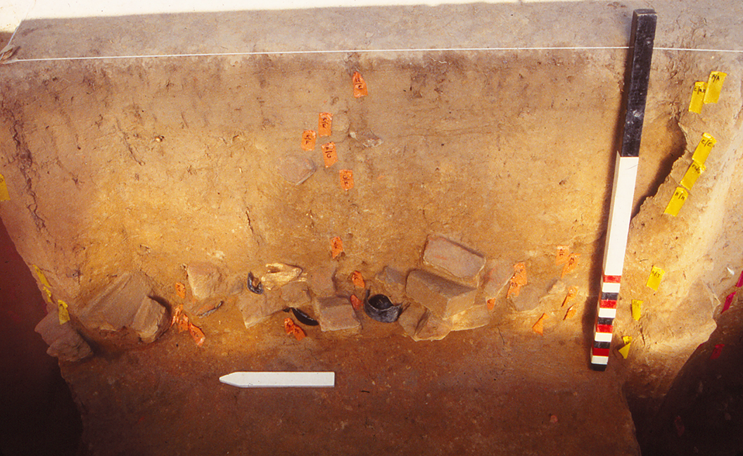
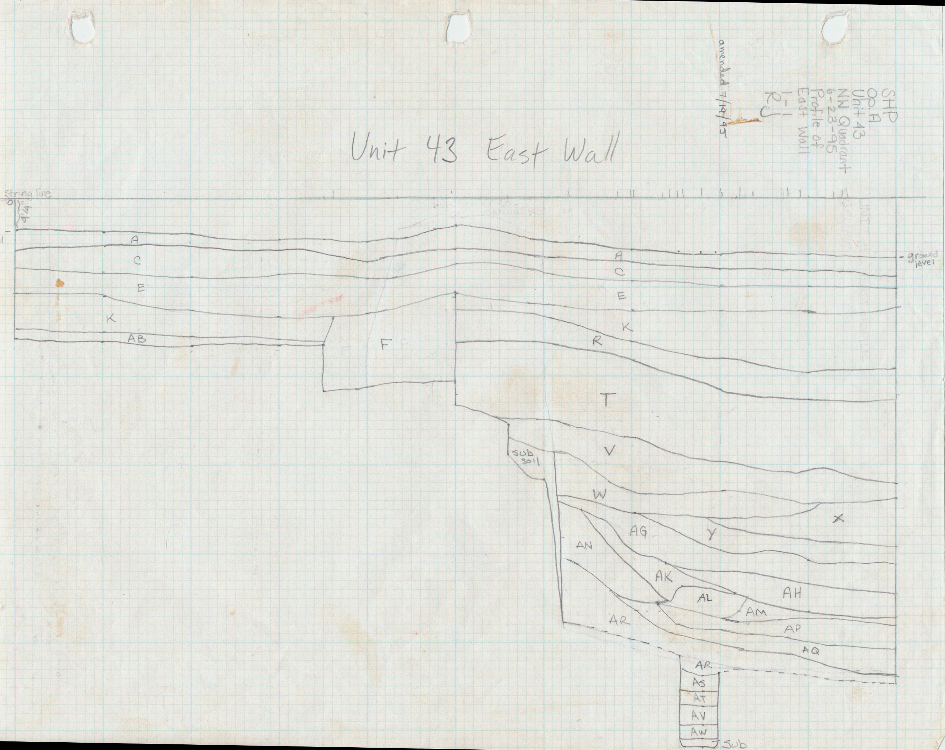
Figure 8: UMW Unit 41, east profile, end of excavation. Image courtesy of University of Mary Washington.
During the 1930s trenching in the northern third of the West Yard, investigators defined a large soil stain feature in close proximity to a 18-x-50 foot rubble foundation. The feature measured approximately 25 (east-west) by 35 feet, and five feet deep (Figure 8), with the latter dimension established by an east-west cross trench through the feature’s northern portion (Sanford 1993:6-8; 1994:6-8; 1995:4-6; 1996:3-4). Interpreted by the 1930s researchers as the pit for an icehouse, the feature remained largely unexplored until the 1990s Field School excavations. Assigning an icehouse function to the depression seemed problematic since most Chesapeake icehouses were based on round pits of much greater depth. Still, the feature’s impressive dimensions and unknown purpose recommended it for further archaeological study, and a series of excavation units implemented during the 1993 to 1996 field school seasons effected a north-south cut through the feature’s western third. Information gathered from this testing operation led Sanford to reinterpret the feature as a borrow pit for clay extraction, with the clay most likely utilized for brick making in a nearby kiln. Sanford’s analysis (see Summary of Research and Analysis) suggests that the borrow pit was in use just prior to the mid-eighteenth century, and that its demise signaled this area’s transition from a brick yard to a service yard for other, utilitarian plantation functions.
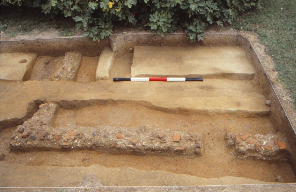
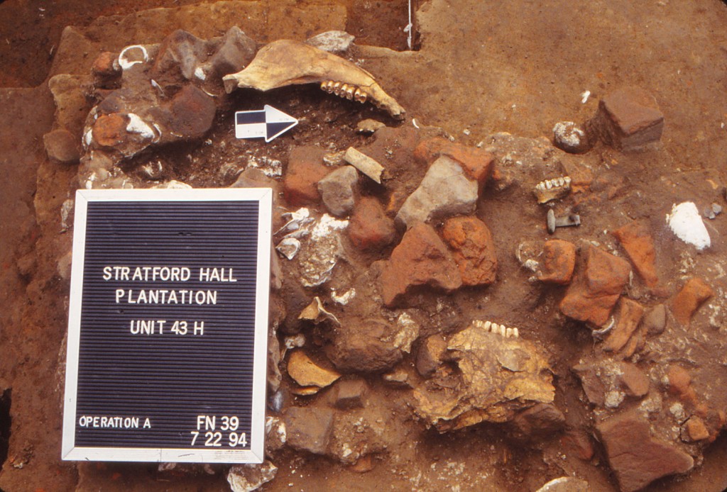
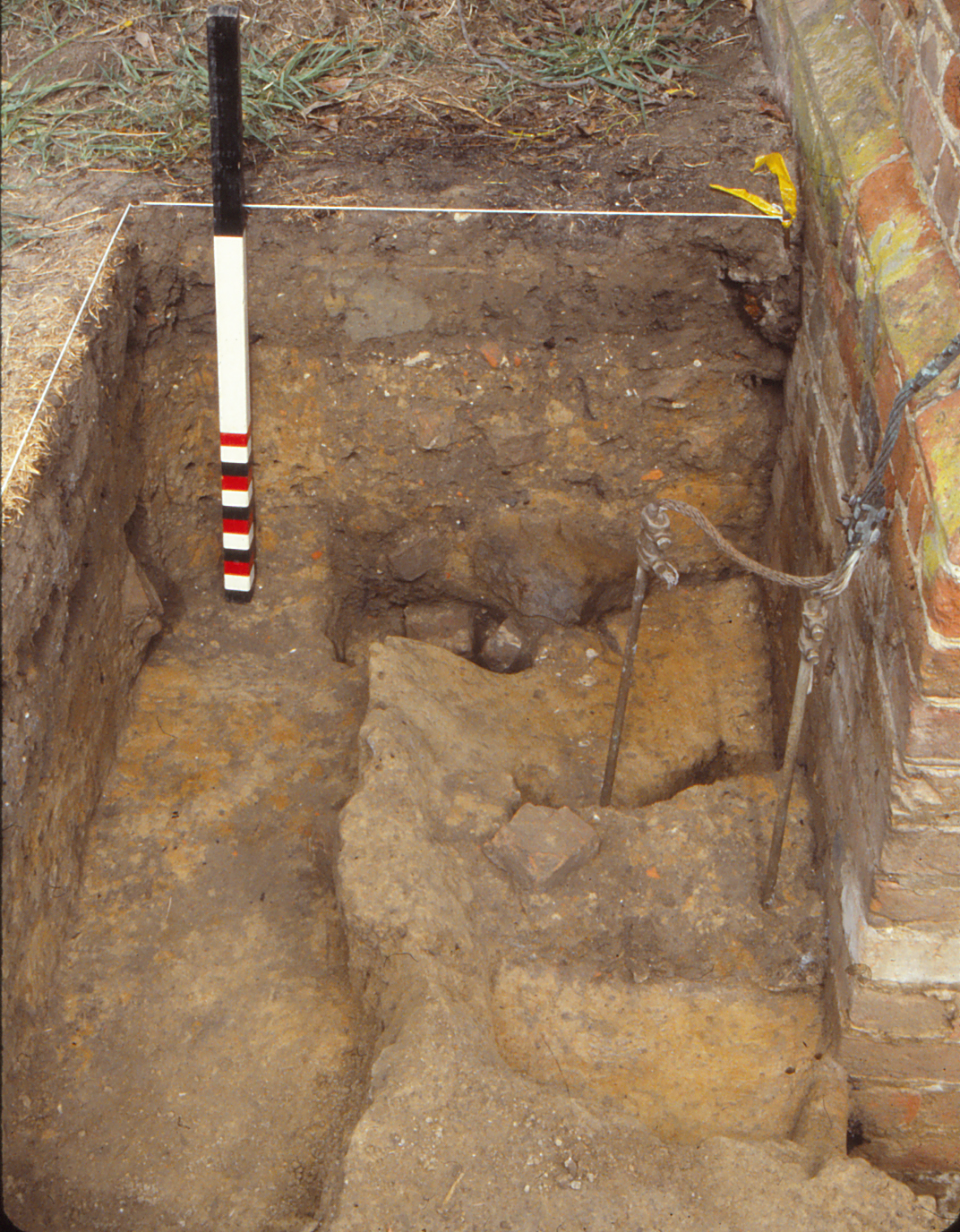
The 18-x-50 foot Outbuilding (UMW Units 30, 31, 43)
First identified during the 1930s archaeological campaigns in the area that became the West Yard, this large structure formerly comprised the northwestern segment of the outbuildings that surrounded the Great House’s western yard. The remains of the structure primarily consisted of a robbed builders’ trench (F10, Figure 9). The location of the southeast corner of the building above the large pit indicates that the building’s construction came after the infilling of the pit. Discussed below, archaeological evidence indicates the building’s demise occurred in the late-eighteenth century. Thus, for at least a few decades, this outbuilding represented a major component of the site and an important landscape feature during the Lee ownership period.
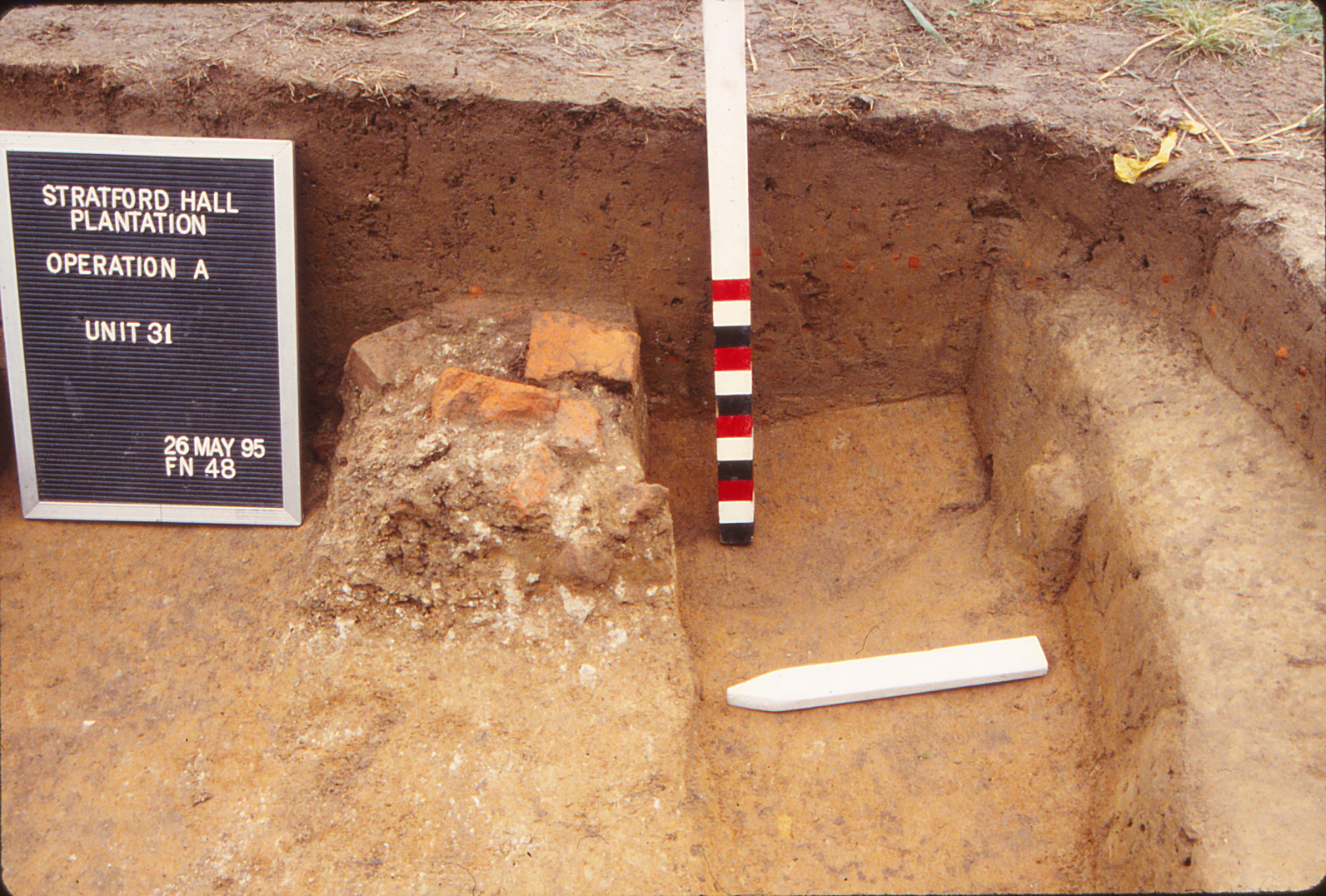
Figure 9: UMW Unit 31, south east profile showing cross-section of robbed building foundation (Feature 10). Image courtesy of University of Mary Washington.
Unfortunately, the building and its vicinity have been heavily disturbed in modern times, making its interpretation problematic. The “aproning” tactic used by 1930s excavators completely divorced the structural evidence from the surrounding stratigraphy, thereby increasing the difficulty of ascertaining the building’s history of construction, use, and demolition. Landscaping activities associated with the restoration as well as modern alterations (e.g. a utility trench for an electric line) disturbed the building site.
The excavation strategy employed during the 1993 to 1995 field school seasons placed three 10-x-10 foot units to examine both ends of the structure, specifically focusing on the southwest (Units 30, 31) and southeast corner (Unit 43) areas (Sanford 1993:5-6; 1994:8-9; 1995:6-7). The latter corner was of interest since it formed the building’s intersection with the previously discussed large pit feature. Additionally, the southwest corner marked a potential location to see the structure’s relation to the surrounding landscape that had been less disturbed by the 1930s archaeological trenching. Also, both building ends were inspected to determine if chimneys had once been part of the structure, thus providing indications of domestic use. Sanford noted (Sanford n.d. Chapter 3, page 13) that excavations failed to find any evidence for chimneys at these locations, which supported the results of the 1930s investigations. The lack of chimneys in the building’s interior strongly suggests a non-domestic use, which aligns with the utilitarian nature of the other outbuildings in the western half of the plantation core. The domestic artifacts found in the upper, disturbed layers of this site apparently derive from the same sources as surmised for other such materials in the West Yard, that is, from worker occupation of some outbuildings. The late-eighteenth to early-nineteenth century date of these artifacts indicates that most of this refuse originated in the period after the 18-x-50 foot building’s use.
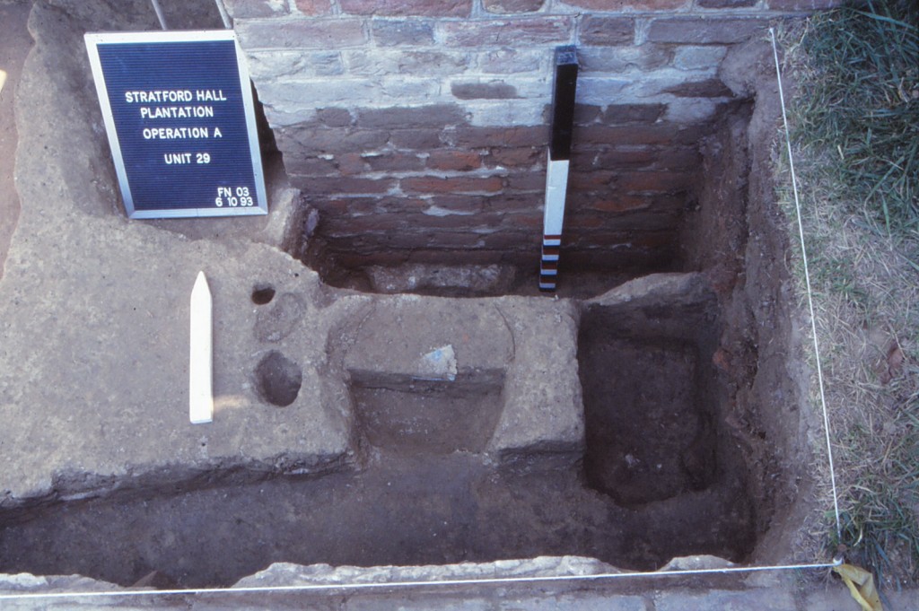
Northwest Outbuilding (UMW Units 29, 34, 178, 179, 180)
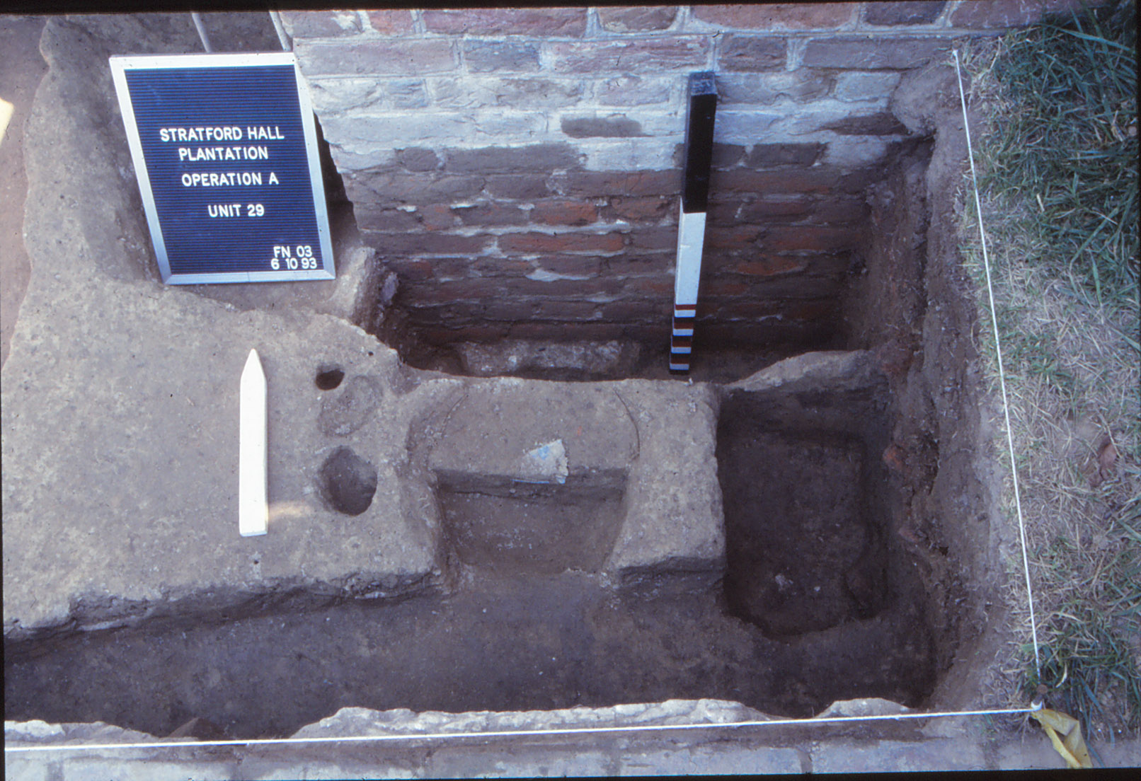
Figure 10: UMW Unit 29, Builder’s Trench (F41) and Posthole (F03).
The primary archaeological objectives for the limited testing adjacent to and near the Northwest Outbuilding included searching for landscape barriers, such as fences, walls, or ditches, that may have terminated at the structure’s southwest corner (Unit 29), and the search for dateable artifacts from the builders’ trench (Sanford n.d. Chapter 3, Pages 16-18; Sanford 1993:7-8; Sanford 1996:4). In a manner similar to that of the 18-x-50 foot building, the upper portions of Unit 29 revealed extensive disturbance due to 1930s archaeological trenching and the restoration activities that followed. Once these intrusions were removed, archaeologists discovered a posthole (F66) on the south side of the outhouse’s southwest corner. The feature’s appearance beneath the modern fills indicates its earlier origin, although providing an exact date is not possible. Still, the posthole’s apparent relation to another posthole (F03, Figure 10) to the south in Unit 34 suggests it was part of a fence line that dates to at least the early- to mid-nineteenth century. The builders’ trench (F41, Figure 10) along the building’s corner is quite narrow and, besides brick and mortar rubble, did not contain dateable artifacts. The exposure of the outbuilding’s brick foundation did reveal the shift in bonding pattern from Flemish above to English below, a standard type of building practice as the foundation/wall reached the structure’s ground surface. Hence, this transition likely indicates the former, Lee period yard elevation (UMW029.W), a level currently about 15 inches beneath the present day grassy turf established during the modern restoration.
1998 John Milner Associates
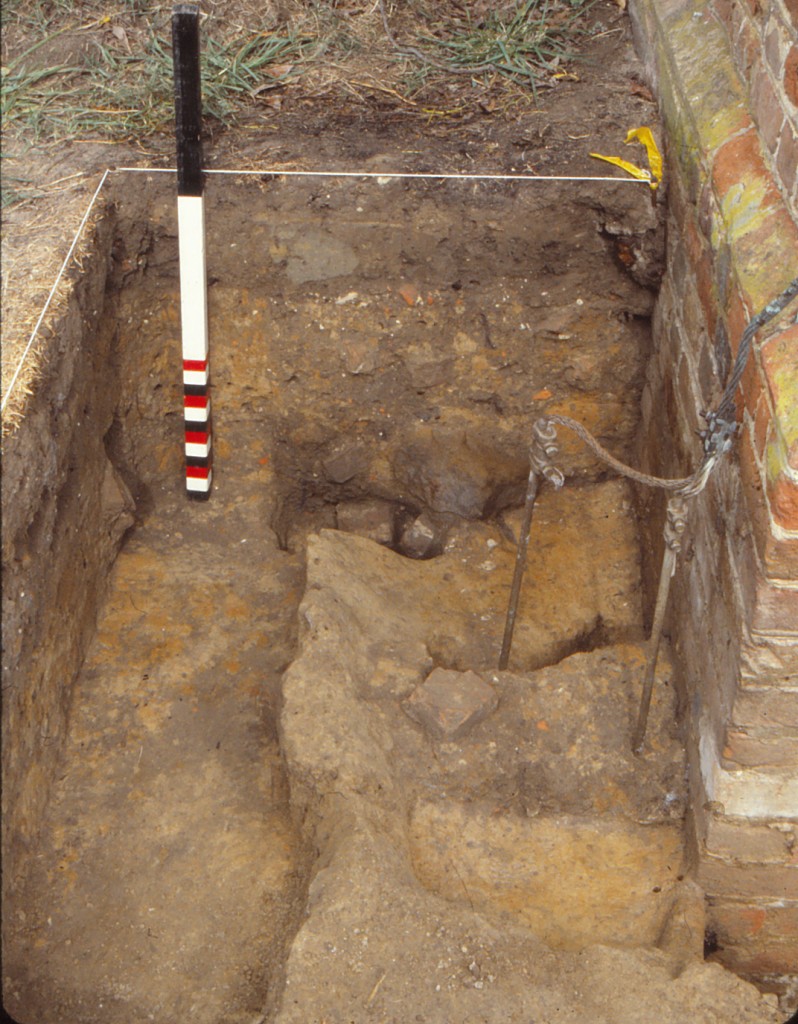
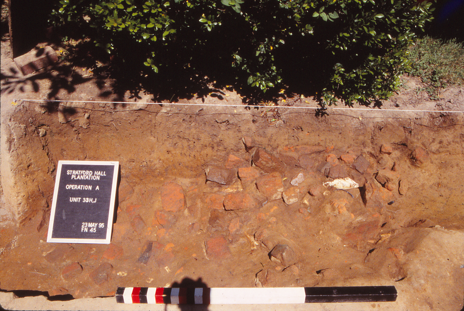
Archaeological investigations at Stratford Hall Plantation were conducted by John Milner Associates, Inc., in 1998 to identify and assess archaeological resources that might be affected by the installation of perimeter drains around the Great House and adjacent outhouses (Balicki and Seifert 1999). The investigations were part of a larger conservation program developed to stabilize the Plantation’s buildings. Thirty-one locations were tested along the perimeters of the seven buildings forming the core of the plantation: the Great House, the Northwest Outbuilding, Northeast Outbuilding, Southwest Outbuilding, Southeast (kitchen) Outbuilding, Smokehouse, and Stable. Only the records and artifacts from 10 quadrats excavated around the Northwest Outbuilding, Southwest Outbuilding, and Stable are included in DAACS because they were located within the boundaries of the West Yard. Three 3-x-3 foot quadrats (JMA Units 101, 102, and 108), one 2-x-3 foot quadrat (JMA110), and six 5-x-5 foot quadrats (JMA Units 103, 107, 109, 111, 112, and 113) were excavated by John Milner Associates.
The results of these excavations supported findings from previous fieldwork. In several locations, the 1930s activities destroyed any archaeological deposits that may have been present around building walls and foundations. In many locations, repainting of brickwork included the excavation of a trench along the base of the walls. However, there were intact archaeological strata identified. For example, the south side of the Southwest Outbuilding was found to contain a preserved former surface. The lowest of the strata may predate construction of both the building and preserved strata associated with the Lee occupation.
2015-2016: DATA Investigations, LLC.
DATA Investigations, LLC., led by Thane Harpole and David Brown, conducted archaeological testing in the West Yard and East Garden in 2015 and 2016. The field records and artifact assemblage data from the DATA Investigations’ excavations in both areas are currently in DAACS. DATA Investigations’ 2015 site report can be downloaded from the Maps and Images section of this website.
The primary goal of DATA Investigations work in the West Yard was to find evidence of historic pathways and other landscape features. Excavations within the west half of the West Yard included Test Units 205 to 224. Excavators worked in natural stratigraphic layers. The majority of the sediment was dry screened through 1/4 mesh. The majority of test units included two layer: topsoil (Layer A) that averaged 0.3-0.4 feet thick, and a likely 1930s plowzone (Layer B) that generally ranged in thickness between 0.4 feet and 0.7 feet. The average depth of the twenty units was about one foot and the two dominant layers included a mix of artifacts from the 18th, 19th, and 20th centuries, with a higher concentration of earlier materials in the lower layer, such as wine bottle glass, white salt-glazed stoneware, and a significant number of Native American lithic flakes and three likely Archaic period projectile points.
Excavations confirmed the locations of previous excavation units (T.U.s 208, 215), shovel tests (T.U. 224), and 1930s trenches (T.U.s 206, 208, 212, 213, 214, 215, 219, 220, 222, and 223), along with potential grid datums (T.U.s 206 and218). These discoveries were significant as they helped place with greater accuracy past excavations, some of which occurred over 70 years earlier.
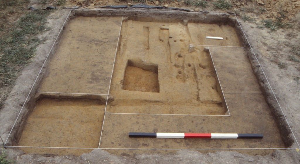
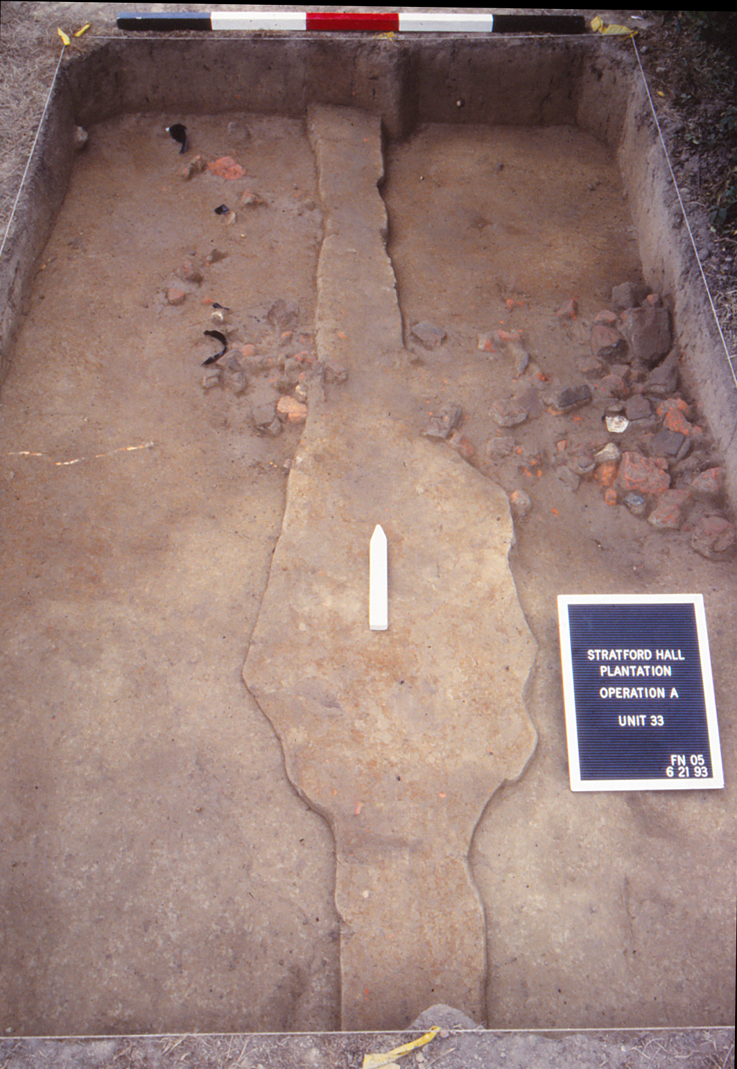
The primary accomplishment of these excavations was the increased sampling across the western half of the West Yard. Perhaps the most dramatic new discovery in this area to date is an 18th-century brick pier, which likely marked an interior partition within an historic building along the north edge of the west yard. While the building has been known archaeologically since the 1930s when excavations uncovered evidence of its existence, and it is referenced in period documents, some of its architectural details, and perhaps its function, are poorly understood.
This brick pier, measuring 1.6 feet east-west and 2.3 feet north-south (Figure 4), was composed of hand made compass bricks, which were likely leftovers from constructing a well on the property, and appears to follow the same orientation as the main house and other outbuildings. The pier was constructed within a linear feature that may have been a planned partition wall, and suggests that the plans for this building may have changed during construction. The association of this brick pier, several post holes, and the linear trench, with the north wall brings into question the
construction sequence for this area and begs for additional testing to better understand its place
within the landscape and connect it with prior excavations near the eastern gable of the
building.
Based on archaeological evidence of plowscars and historic photographs, the West Yard
was plowed following the completion of trenching archaeology by Shurcliffe and Williams in
the early 1930s. While this event would have turned over intact layers and dispersed artifacts to
a limited extent, it does not appear to have been particularly deep and may not have covered the
entire space to an equal depth. It is also possible that the plowscars could represent limited
earlier plowing, as they lack the width and regularity of more modern plowing. Either way, it
does not appear that plowing has significantly altered the interpretive potential of this layer, and
this layer should continue to be treated as a valuable cultural context with information about
activities in this area throughout its history.
Summary of Research and Analysis
The West Yard site has been analytically and archaeologically revisited periodically since the initial excavations in the 1930s. Evidence from excavations by the Virginia Research Center for Archaeology, University of Mary Washington, and John Milner Associates confirms that the vast majority of the central portion of the entire West Yard area has been disturbed (plowed) to a depth of about one foot. Investigations of the outer perimeter of the West Yard space revealed better preservation of older soil layers and features, and archaeological efforts in later seasons focused in this area. Another noteworthy result from the University of Mary Washington’s excavations is the lack of artifacts clearly dating to the opening decades of the plantation use (1730s to 1760s). This lack of evidence indicates either that much of the area was not utilized on a regular basis until at least after ca. 1750 or that the deposits dating to this time period are no longer discernible in the archaeological record.
Two principal features discovered during the archaeological investigations were the robbed brick foundation of an 18-x-50 foot outbuilding (DAACS Feature Group 01, Figure 11) and a large rectangular pit (F01, Figure 12) located in the northern portion of the West Yard. Recent re-cataloging of the assemblage and related reanalysis of the site stratigraphy by the Principal Investigators and DAACS staff provides new insights into the history and dynamics of these features.
18-x-50 foot outbuilding
Sanford
While limited, the available archaeological and artifact evidence does allow some reasonable speculation as to the 18-x-50 foot outbuilding’s construction and use. Wrought nails and window glass fragments indicate that a frame superstructure with glazed windows rested on a mortared, one foot wide brick foundation. This base could support a one-and-a-half story structure that likely had a gable roof with wood shingles that was oriented to the building’s long (east-west) axis. The previously noted lack of chimneys, as well as a similar absence of artifacts denoting a specific craft activity, suggest that the outbuilding functioned as a stable or barn, or perhaps as general storage. No below-ground indications for interior partitions were discovered in the 1990s excavations, although the site’s disturbed condition, the limited area encompassed by these test units, and the possibility of partitions existing at the floor (above ground) level of the structure may explain this missing architectural evidence. Nonetheless, the building’s existence and destruction provide critical information as to the appearance of the service yard landscape, and the degree to which changing land use formed a consistent component of the yard’s long-term history (Sanford n.d.:Chapter 3, pages 14-15).
At the southeast corner (Unit 43) of the 18-x-50 foot building, the robbed foundation contained a distinctive mixture of domestic refuse not seen in other segments of the structure footprint. Artifacts included animal bone and oyster shell, an unidentified brass implement, and a number of ceramic ware types including creamware, pearlware, ironstone, and white salt glazed stoneware. The presence of creamware within this backfill material dates the structure’s demolition to the post-1770 time period. This evidence, in tandem with the date of the artifacts within the disturbed strata above the foundation, imply an end date of the late-eighteenth century for this outbuilding. Overall, the years from ca. 1750 to 1800 provide a generous estimate of the building’s life span, although a shorter use of a couple decades is possible based on the limited dating evidence. In either interpretation, during its occupation an immediate yardscape of activities once surrounded the outbuilding. Future archaeological study in this vicinity could search for indications of the land use that prevailed during this time period.

Figure 11: Robber’s trench uncovered in Units 30 and 31, facing North.
Beyond its disturbed context, Sanford noted two main qualities that distinguish this particular outbuilding (Sanford n.d.:Chapter 3, pages 14-15). One is its considerable size, with the long rectangular format signaling that the structure was not intended as a standard smokehouse, dairy, or other small service building. The completely robbed nature of its original brick foundation (Figure 11) defines the second quality. This brickwork was removed down to the clay subsoil beneath the foundation, and then leftover broken brick and mortar rubble was thrown back into the foundation trench, leaving a wavering “footprint” that delineated the structure’s outline below ground. The extensive degree of demolition infers that the structure’s razing was intended to prepare this area for a forthcoming, alternative land use. Plow scars recorded both within and outside the building’s limits provide some evidence of this land use, in that the plowing denoted either a shift to agricultural activity or a landscaping treatment that leveled the area for some other purpose in the late eighteenth or early nineteenth century. The disturbed condition of the vicinity prevented defining this later purpose.
DAACS
Analysis of the ceramic assemblage associated with the deposits determined to be part of the 18-x-50 foot outbuilding (DAACS Feature Group 01) revealed a BLUEMCD of 1794. This range roughly aligns with the time period recorded by Sanford. However, it should be noted that the sample size was small as the assemblage was comprised of 12 sherds.
Feature 01
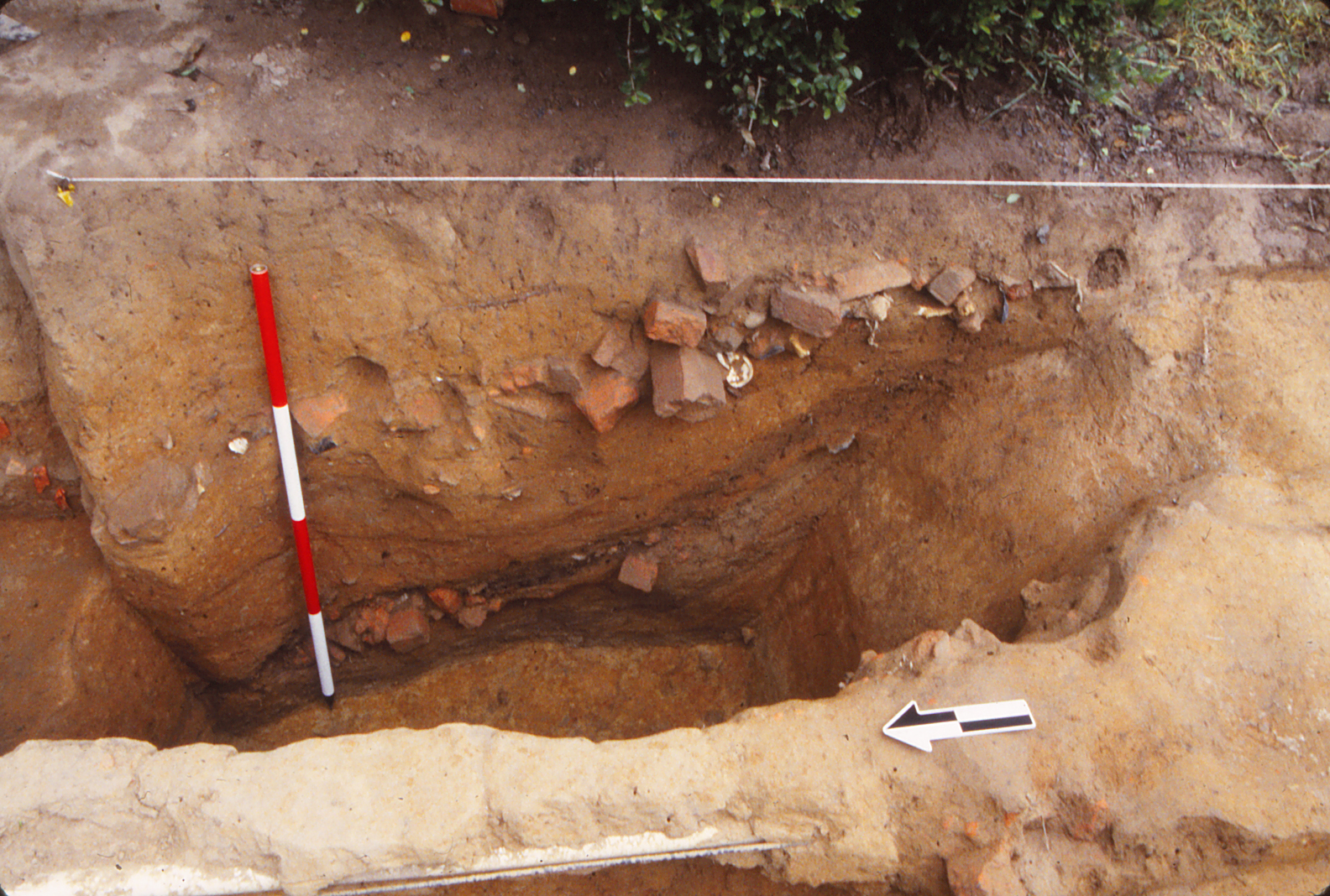
Sanford
Sanford’s review of Feature 01’s elements and stratigraphy led him to differentiate four main periods of activity, ranging from initial use to final backfilling (Sanford n.d.: Chapter 3, pages 8-12). Modern, thin layers above the feature correspond to the restoration period and more recent activities, but do contain important dating evidence. Domestic and architectural artifacts of the late-eighteenth and early-nineteenth centuries, that is, of the same variety and occupation span seen throughout the West Yard, occur within the layers above the borrow pit and thus indirectly date its use and backfilling to a period prior to about 1770.
Sanford noted that while roughly rectangular and of the dimensions discovered in the 1930s, the borrow pit’s actual plan and profile outlines are not so uniform. He notes that the overall north-south profile developed by the field school test units revealed a shallow slope on the south end that contrasts with the north side’s steeper incline and suggests that the clay extraction process proceeded in a south-to-north direction. Additionally, the pits’ western edge is somewhat irregular, broken in places by what appear to be smaller, subsidiary pits. In addition, two large (~8 inches in diameter) postholes (Features 44 and 45 in DAACS) discovered on this western side of the pit may represent posts for covering the pit with a tarp or rough wooden roof, or possibly for a hoist arrangement (recorded in DAACS as Feature Group (FG) 05). Finding additional postholes on other sides of the borrow pit would clarify the accuracy of these speculations.
Based on this evidence, Sanford concluded that the initial or first period of the feature corresponds to the pit’s use as a clay borrow pit of an impressive scale. If the pit feature’s use dates to the 1740s or earlier, then it is likely that the borrow pit may have been associated with construction of one or more of the western outbuildings rather than the Great House.
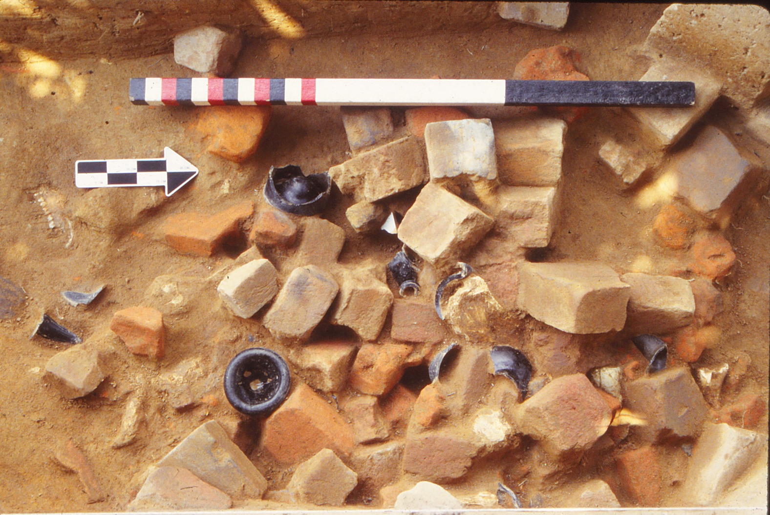
Sanford argues that the borrow pit’s second period is marked by its initial backfilling. Once the pit ceased to supply clay, it began to fill in by way of silting and erosion. Mixed layers of clays, silts, and sand dominate the feature’s lower portion. Sanford dated the third period roughly to the decade of the 1740s based on wine bottle necks and bases. The borrow pit became a convenient trash pit for ongoing activities in the plantation’s service yard. A highly concentrated and distinctive combination of artifacts was recovered from the feature’s middle layers, and this combination offers direct clues to the nature of service yard’s multiple uses. First, only limited quantities of ceramics and architectural materials (window glass, nails) were discovered, along with some oyster shell. Most ceramic sherds represented storage vessels of tin-glazed earthenware (Delft) and coarse red earthenware. The sloping nature of the artifact-laden deposits indicated that refuse was thrown in from both sides of the pit. Higher quantities of three particular artifact types dominate the assemblage – green wine bottle glass, animal bone, and brick bats. The considerable number of wine bottle fragments, predominantly large neck and base sections, also indicated a similar pattern of refuse disposal in which bigger pieces of broken bottles were “curated” for dumping from nearby activities. Besides general domestic use, these bottles possibly originated from the plantation store outbuilding to the south, that is, from the brick structure situated in between the Southwest Outbuilding and the Coach House/Stables.
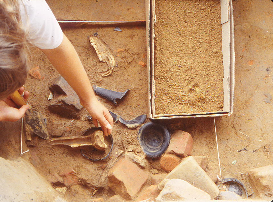
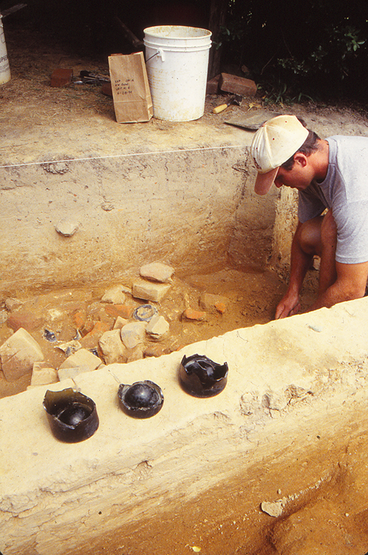
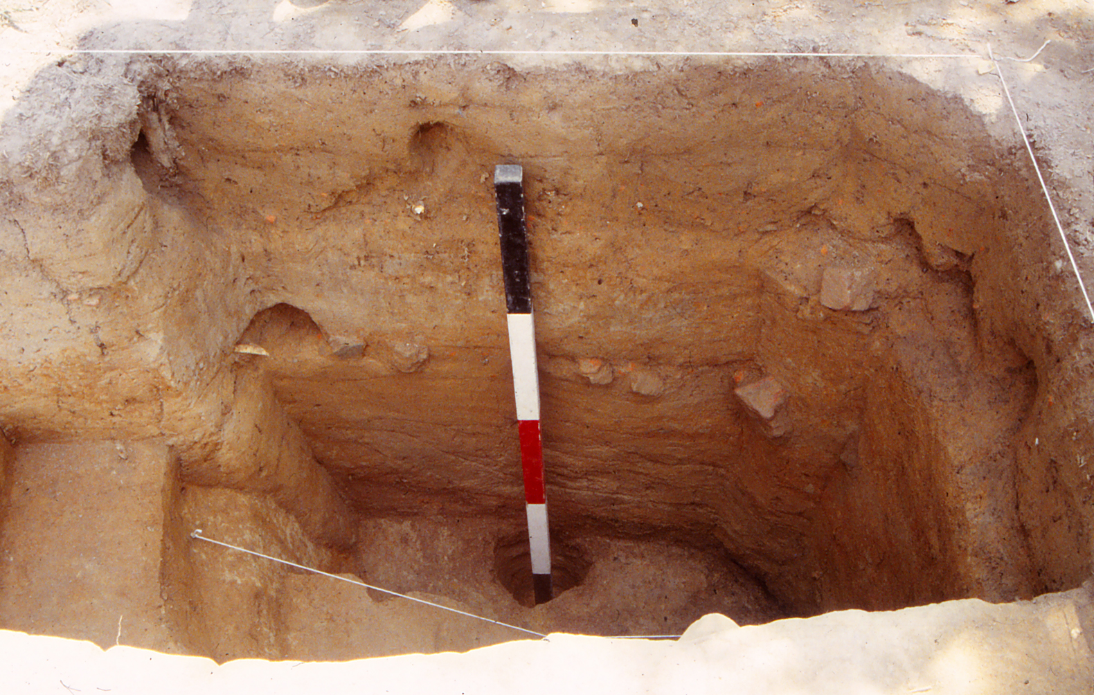
Figure 12: UMW Unit 41, excavation of context N (Feature 01). Image courtesy of University of Mary Washington.
Finally, the recovery of larger bone fragments suggested these materials stemmed from larger mammals and from the initial stages of butchering for meat. A preliminary faunal analysis of over 400 bones from the main artifact-bearing layers of the borrow pit supplies support for this field interpretation (Barber 1997). Identification of species, body part representation, and butchery marks indicates that the borrow pit bones follow meat diet practices common to Chesapeake plantations of the eighteenth-century period (ibid). The selection emphasized cattle and pig as compared to sheep and the 2:1 ratio of cattle to pig bones infers the primacy of beef over pork in this case. The limited number of individuals per species (less than 4) suggested a short time period of deposition, as does the concentrated nature of the wine bottles. Importantly, the dominance of lower limb (shank) and head bones, those elements typically discarded during the initial stages of butchery, implies that this stage of rendering domestic animals into meat was common in the service yard, rather than the later stages of reducing sides of beef and pork to consumable portions. Consequently, the evidence reinforces the interpretation of the West Yard as originally a multifaceted work yard. In related fashion, the later stages of processing, storing, and disposing of consumed meat by-products occurred in the southeast portion of the mansion complex, namely within the smokehouse, meathouse, and kitchen complex.
Sanford defined the fourth and last period for the borrow pit by the presence of a series of backfill deposits dominated by relatively “clean” (artifact-free) clay soils. The distinctive mixture of the orange-to-red sandy clays utilized in this final infilling operation points to alternative origins for the material. These soils may represent excess processed material for brick-making that was redeposited in the borrow pit, and similar layers were noted in the backfilling of the ravine that fronted the reconstructed slave quarters, another area for brick making on the plantation. Conversely, the clay soils could correspond to excess material from period digging for foundations, a well, or other borrow pits. A final purpose for capping the borrow pit, other than tidying up an eye-sore, was to prepare the area for the construction of the extant 18-x-50 foot outbuilding.
Overall, Sanford argues that the stratigraphic sequences within and on top of the borrow pit feature provide some of the best evidence at Stratford for the regular pace of landscape change that took place on this plantation between ca. 1750 and 1800. The larger shift from a place of construction activity (brick-making) to a work yard encompasses both a series of minor changes in land use, but also the significant erection of at least five outbuildings that bordered the service yard. The same fills of the borrow pit also should contain a significant body of landscape information with respect to botanical evidence. The dense clays that sealed the feature likely enhanced the degree of organic preservation within the lower deposits, and pollen and phytolith studies would provide a valuable index of the plantation’s plant environment and its changing nature.
DAACS
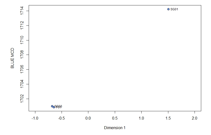
Figure 13: Plot of CA Dimension 1 scores for SG assemblages plotted against Mean Ceramic Dates, labeled by context.
Analysis of Feature 1’s stratigraphy by DAACS staff identified five stratigraphic groups (SGs), which were interpreted as five different fill layers within the feature (see Harris Matrix). However, the ceramic assemblage sizes were too small (< 5 sherds) to calculate Mean Ceramic Dates for SG02, SG04, and SG05. A plot of the Dimension 1 scores against BlueMCDs for the remaining SGs and Feature 1 contexts (Figure 13) indicates that there is temporal variation between SG01 (BlueMCD 1714) and SG03 (BlueMCD 1701) and between SG01 and the rest of the contexts associated with Feature 01 (BlueMCD 1700) that have not been classified into stratigraphic groups. A closer look at assemblage composition indicates these differences are due to greater amounts of delftware in SG03 contexts while British Stoneware and White Salt Glazed Stoneware are the primary ware types comprising the SG01 assemblage and Post-Medieval London-area Redware predominates the rest of the Feature 01 contexts. These results support Sanford’s conclusion that the pit had different phases of use, but it is not clear whether the phases revealed by the correspondence analysis align with the ones outlined by Sanford. Moreover, because excavations to date have not revealed the full east-west extent of the pit, it is difficult to say with certainty what function it could have served. It is possible that future work will provide more information.
Elizabeth Bollwerk¹, with Douglas W. Sanford²; Fraser Neiman³; Joseph F. Balicki ¹¹, Donna J. Seifert¹¹, Thane H. Harpole¹², and David A. Brown¹²
¹DAACS, ²University of Mary Washington; ³Thomas Jefferson Foundation, Inc.; ¹¹John Milner Associates, Inc., ¹²DATA Investigations, LLC.
January 2016. Updated April 2021 to include data from DATA Investigation, LLC.
Things you need to know about Stratford Hall’s West Yard before you use the data:
- In the DAACS database, West Yard is designated as Project “1038”. Artifact ID numbers for artifacts associated with the site therefore begin with the 1038 prefix.
- Excavated contexts followed natural stratigraphy.
- Most contexts were screened through ¼ inch mesh but a significant portion were not screened. These differences are captured as a prefix in the Artifact IDs (e.g. NOS for Not Screened, and DRS for Dry Screened).
Stratford Hall’s West Yard was the site of five different archaeological campaigns between 1930 and 2016. During the majority of those excavations, the site was referred to as the West Garden. Since the area west of the Stratford Hall mansion was not used as a garden until the 1940s, DAACS, along with the RELMA and Dr. Doug Sanford, have agreed to rename the area the West Yard.
The following notes describe DAACS’s efforts to ensure that contexts and artifacts from each season are easily distinguished from other field seasons. These efforts also ensure that original naming conventions were retained to the greatest extent possible.
Naming Conventions for Contexts and Quadrats
- Sanford and the University of Mary Washington (formerly Mary Washington College):
- Douglas Sanford and his team from Mary Washington College Historical Preservation department identified quadrats by a three-digit unit number. Stratigraphic layers within the unit were identified by a letter. For example, 003.A represents Layer A in Unit 003. In 2004, Mary Washington College became University of Mary Washington. Consequently, in DAACS, contexts excavated by the MWC team have a “UMW” prefix followed by the three-digit unit number, followed by “.” and then the letter indicating the specific layer, e.g., “UMW003.A”.
- Quadrat IDs are named similarly, e.g. “UMW003.”
- In cases where “test cuts” or “subunits” were excavated within (usually) 10-by-10 foot units, Quadrat IDs are named according to their corner placement within the larger unit. For example, a test cut placed in the northeast corner of the larger unit, the QuadratID is “UMW021NE.” If there is more than one layer excavated in the test cut, contexts have additional suffixes with the original letters, e.g., “UMW021NE.H.”
- In the UMW excavations, the letters “I” and “O” were not used as letter designation for contexts.
- Neiman and the VCRA:
- Fraser Neiman and his team also identified quadrats by a three-digit unit number. Stratigraphic layers within the unit were identified by a letter, e.g., 168.A represents Layer A in Unit 168. In DAACS, contexts excavated by Neiman have a “VCRA” prefix followed by the three-digit unit number, followed by “.” and then the letter indicating the specific layer, e.g., “VRCA168.A”.
- Quadrat IDs are named similarly, e.g. “VRCA168.”
- John Milner and Associates:
- Similarly, John Milner and Associates identified quadrats by a three-digit unit number. Stratigraphic layers within the unit were identified by a letter, e.g., “101.A” represents Layer A in Unit 101.
- In DAACS, contexts excavated by Milner and Associates have a “JMA” prefix followed by a three-digit unit number, followed by “.” and letter indicating specific context, e.g., “JMA101.A.”
- Quadrat IDs are named similarly, e.g., “JMA101.”
- DATA Investigations::
- Finally, DATA Investigations also identified quadrats by a three-digit unit number. Stratigraphic layers within the unit were identified by a letter, e.g., “257A” represents Layer A in Unit 257.
- In DAACS, contexts excavated by DATA Investigations have a “DI” prefix followed by a three-digit unit number, followed by a letter indicating specific context, e.g., “DI257A.”
- Quadrat IDs are named similarly, e.g., “DI257.”
Conventions Specific to UMW Excavations
- Features and Unnumbered Features: During the UMW excavations, many modern planting features were recovered and given alphanumeric assignments within the layer (e.g., stake holes H01 – H12 in Context H). In DAACS, such modern planting features were assigned a Unit Type of “Unnumbered Feature.”
- Unnumbered features found within a single layer were given alphanumeric assignments within that layer (e.g., stake holes H01 – H12 in Context (layer) H). If opening and closing elevations were noted, these data are recorded in the Excavator Description field. The depth of the unnumbered feature is recorded as Max LS Thickness.
- Feature 01: Field records indicate that F01 was not excavated to subsoil in Unit 41 (UMW041). In addition, excavators employed a test cut strategy using a posthole digger to reach subsoil below F01 in Unit 43. (UMW043).
“Deposit Type” field for contexts
In many UMW units, original excavators recorded a deposit type of “transition to subsoil.” According to Sanford, this designation was reached based on the following criteria: “In most cases, this soil layer contained tiny amounts of charcoal, brick flecks, and at times, minute stone flakes. Rather than being cultural deposits, we felt these materials had entered the transition soil through natural means – bioturbation, worms, water percolation, etc.”
Pollen Samples
For some units, the University of Mary Washington excavators noted that they took pollen samples. These were not entered as Context Samples in the Context table because there was not enough information present to record; rather, any information was recorded in the field description notes of the corresponding Context Record.
Inclusions
Brick fragments, oyster shell, mortar, charcoal were found in varying quantities throughout all contexts excavated by UMW field schools. Due to this prevalence, it was unclear what kind of sampling of each artifact type occurred from context to context and unit to unit. In discussion with Sanford, DAACS staff instituted a protocol that collected samples of these artifact types would not be cataloged as separate records in the “All Other Artifacts” table. Instead, for contexts with these artifact types, each type would be recorded as an inclusion within the Sediment Information table. Exceptions include: 1) brick fragments or brick bats with measurable dimensions; 2) artifacts (usually brick or mortar) weighed and discarded in the field; 3) burned oyster shell. In the Data Entry Notes for relevant contexts, a note was added explaining this approach.
Notes on the Recording of Specific Artifact Types.
- Faunal material was entered according to the “non-specialist” protocols (see Faunal manual for more information).
- Modern general artifacts were batched according to protocols outlined in the All Other Artifacts manual. A brief summary of materials included in the batch can be found in the Notes field.
- Modern terra cotta flower pot sherds were batched in a single Ceramic table record regardless of completeness. Only count and weight of the sherds was recorded.
- UMW excavators made a distinction between “grey” mortar identified as “possibly modern” and historic mortar, which was usually either white or tan. This distinction was preserved for contexts in which it was noted by the excavators.
- DATA Investigations discarded architectural artifacts in the field (brick, larger chunks of mortar, charcoal, coal, and oyster shell). DAACS staff developed protocols for these artifacts and entered counts and weights for each context based on documentation from artifact tags and field/lab records.
- Numerous fragments of conglomerate were found throughout the West Yard. This “ferricrete” or ferruginous sandstone most often consists of iron and quartz. These naturally-occurring stones (also known as bog iron) are likely from localized outcroppings of ferricrete on the Stratford plantation and elsewhere on the Northern Neck of Virginia. This conglomerate was used in the historic period for foundations, walls, chimneys, and headstone markers. Cultural uses can be established using the size of the fragment and the context of the assemblage. Because all of the ferricrete/bog iron recovered from Stratford was pebble or cobble-sized, did not show signs of wear, reuse, or other modification, and none of the contexts it was found in indicated it was used culturally, it was not entered into the database.
- There are a number of glass fragments that are recorded with post manufacturing modification. The necessary and sufficient criterion for recording a glass fragment as modified/worked was three overlapping conchoidal fractures.
- Several artifacts were removed for exhibit or for further research and were not found at the time of analysis. Records were created in the appropriate table and the description from removal cards was recorded in the Notes field.
Artifacts are missing for two of the units excavated by Neiman et al.: VRCA141 and VRCA142. In this case, artifact information was entered into the relevant Artifact Tables based on original finds lists.
Things you should know about the Site Map
- The DAACS site map for the West Yard is based on a composite map created by the Cultural Landscape Lab at the University of Georgia, as well as the VRCA 1976 plan view excavation map. These two maps were scaled and aligned. Additional units excavated by the University of Mary Washington that did not appear on these maps were placed by using coordinates provided by Dr. Douglas Sanford. Grid North is aligned with the axis of the main house and is 11.5 degrees west of true north.
- 0,0 (origin) for the West Yard is located at the northwest corner of the main house.
- Map measurements are in feet and tenths of feet.
- The maps are not projected into a real world coordinate system. The coordinates provided correspond to locations on the local grid for the site.
Feature Numbers
In order to create a uniform feature number system across all years and excavators at West Yard, DAACS staff assigned feature numbers using an F-prefix that precedes the number (e.g. F01 is Feature 1).
Please note: field records indicate that F01 was not excavated to subsoil in Unit 41 (UMW041). In addition, excavators employed a test cut strategy using a posthole digger to reach subsoil below F01 in Unit 43. (UMW043).
Feature Groups
Feature groups are sets of features whose spatial arrangements indicate they were part of a single structure (e.g. structural postholes, subfloor pits, and hearth) or landscape element (e.g. postholes that comprise a fenceline). Feature Groups assigned by DAACS have a FG-prefix, which precedes the number (i.e. FG01 equals Feature Group 1). Feature Groups were not assigned by the original excavators of West Yard.
| Feature | Feature Type | Contexts |
|---|---|---|
| F09 | Rubble Scatter | UMW043.R, UMW043.M |
| F10 | Trench, robber’s | UMW043.AE, UMW030.R, UMW043.AC, UMW043.Q, UMW043.AF, UMW043.AD, VRCA142.D, UMW031.P, UMW043.H, UMW043.P |
| F54 | Previous Archaeology | UMW030.L, UMW030.J, VRCA142.B |
| F55 | Previous Archaeology | UMW030.K |
| F79 | Pier, brick | DI216F79, DI222F79 |
| Feature | Feature Type | Contexts |
|---|---|---|
| F12 | Trench, builder’s | UMW178.M |
| F17 | Trench, repair | JMA101.B |
| F33 | Trench, repair | UMW179.F |
| F49 | Trench, builder’s | UMW178.G |
| F52 | Trench, repair | JMA103.C |
| F53 | Trench, builder’s | JMA102.F |
| F57 | Trench, repair | UMW180.L, UMW180.K |
| F58 | Trench, repair | UMW180.R, UMW180.N |
| F59 | Trench, repair | UMW180.J, UMW180.H |
| F60 | Trench, builder’s | UMW180.Q, UMW180.P |
| Feature | Feature Type | Contexts |
|---|---|---|
| F13 | Previous Archaeology | UMW037.M |
| F14 | Previous Archaeology | UMW043.F |
| F15 | Previous Archaeology | UMW034.F |
| F16 | Previous Archaeology | UMW071.F |
| F18 | Previous Archaeology | UMW043.G |
| F19 | Previous Archaeology | UMW043.J |
| F20 | Previous Archaeology | UMW031.K |
| F21 | Previous Archaeology | UMW031.H |
| F22 | Previous Archaeology | UMW031.J |
| F24 | Previous Archaeology | UMW029.K |
| F25 | Previous Archaeology | UMW029.P |
| F26 | Previous Archaeology | UMW029.R |
| F27 | Previous Archaeology | UMW029.S |
| F28 | Previous Archaeology | UMW041.D, UMW032.K1 |
| F30 | Previous Archaeology | UMW042.G |
| F31 | Previous Archaeology | VRCA172.C |
| F32 | Previous Archaeology | UMW032.K2 |
| F51 | Previous Archaeology | VRCA170.H |
| F61 | Previous Archaeology | UMW178.J1, UMW178.J2 |
| F62 | Previous Archaeology | UMW179.J |
| F70 | Previous Archaeology | DI206F70 |
| F73 | Previous Archaeology | DI212B |
| F74 | Previous Archaeology | DI213C |
| F75 | Previous Archaeology | DI213D |
| F77 | Previous Archaeology | DI214B |
| F80 | Previous Archaeology | DI220C |
| F81 | Previous Archaeology | DI222B |
| F82 | Previous Archaeology | DI228B |
| F83 | Previous Archaeology | DI257C |
| F84 | Previous Archaeology | DI259B |
| F85 | Previous Archaeology | DI260B |
| F86 | Previous Archaeology | DI222F86 |
| Feature | Feature Type | Contexts |
|---|---|---|
| F34 | Trench, utility | UMW031.D, UMW031.E |
| F37 | Trench, utility | UMW033.C |
| F38 | Trench, utility | UMW032.E |
| F39 | Trench, utility | UMW064.C, UMW064.F |
| F40 | Trench, utility | UMW064.D |
| F42 | Trench, utility | UMW041.B |
| Feature | Feature Type | Contexts |
|---|---|---|
| F01 | Pit, unidentified | UMW032.M, UMW032.N, UMW032.P, UMW032.R, UMW032.S, UMW032.T, UMW032.V, UMW032.W, UMW032.X, UMW032.Y, UMW032SWAB, UMW033.AA, UMW033.AB, UMW033.AC, UMW033.AD, UMW033.AE, UMW033.AF, UMW033.AG, UMW033.AH, UMW033.AJ, UMW033.AK, UMW033.AL, UMW033.AM, UMW033.AN, UMW033.AP, UMW033.AQ, UMW033.AR, UMW033.AS, UMW033.AT, UMW033.AV, UMW033.AW, UMW033.AX, UMW033.BA, UMW033.BC, UMW033.BD, UMW033.BE, UMW033.BF, UMW033.BG, UMW033.BH, UMW033.BJ, UMW033.K, UMW033.L, UMW033.Q, UMW033.R, UMW033.S, UMW033.T, UMW033.V, UMW033.W, UMW033.X, UMW033.Y, UMW041.H, UMW041.K, UMW041.M, UMW041.N, UMW041.P, UMW041.Q, UMW041.R, UMW041.S, UMW041.V, UMW041.X UMW042.AB, UMW042.AC, UMW042.AD, UMW042.AE, UMW042.AF, UMW042.AG, UMW042.AJ, UMW042.AK, UMW042.AL, UMW042.AM, UMW042.AN, UMW042.F, UMW042.L, UMW042.M, UMW042.N, UMW042.P, UMW042.Q, UMW042.R, UMW042.S, UMW042.T, UMW042.V, UMW042.X, UMW042.Y, UMW043.AG, UMW043.AH, UMW043.AJ, UMW043.S, UMW043.T, UMW043.V, UMW043.W, UMW043.X, UMW043.Y, UMW043SEAK, UMW043SEAL, UMW043SEAM, UMW043SEAN, UMW043SEAP, UMW043SEAQ, UMW043SEAR |
| F36 | Posthole | UMW033.M, UMW033.N, UMW033.P, UMW033.P1, UMW033.P2 |
| F44 | Posthole, possible | UMW041.L |
| F45 | Posthole, possible | UMW041.T |
| Feature | Feature Type | Contexts |
|---|---|---|
| F02 | Pit, unidentified | UMW034.M, UMW034.N, UMW034.R, UMW034.Q, UMW034.P, UMW034.L |
| F03 | Posthole | UMW034.J, UMW034.K |
| F04 | Posthole | UMW035.K |
| F05 | Posthole | UMW070.C, UMW070.D |
| F06 | Posthole | UMW070.J |
| F07 | Postmold | UMW067.F |
| F08 | Postmold | UMW067.D |
| F11 | Pit, unidentified | UMW030.Q1 |
| F35 | Posthole | UMW063.E, UMW063.F |
| F41 | Trench, builder’s | UMW029.V |
| F43 | Posthole, possible | UMW041.J |
| F46 | Trench, unidentified | UMW042.W |
| F47 | Trench, unidentified | UMW042.AH |
| F48 | Trench, builder’s | JMA110.C |
| F50 | Pit, unidentified | VRCA141.C |
| F56 | Posthole | UMW003NW.H |
| F63 | Trench, unidentified | JMA111.E |
| F64 | Brick in Course | JMA111.J |
| F66 | Posthole | UMW029.AA |
| F67 | Ditch, other | UMW068.D, UMW068.E |
| F68 | Posthole, possible | UMW061.D |
| F71 | Posthole | DI207F71 |
| F72 | Previous Archaeology | DI208B |
| F76 | Tree hole | DI214F76 |
| F78 | Previous Archaeology | DI215B |
| F87 | Previous Archaeology | DI239F87 |
Intra-Site Chronologies
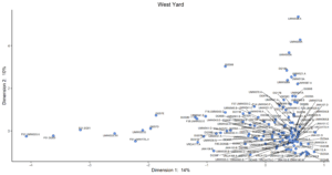
Figure 1. Plot of contexts, features, and stratigraphic groups along CA dimensions 1 (Inertia 14%) and 2 (Inertia 10%). Time runs left to right. Assemblage labels include prefixes for features (F), and Stratigraphic Groups (SG).
DAACS has developed a uniform set of methods to infer intra-site chronologies for all of the sites included in the Archive. These methods, which include frequency-seriation and correspondence analysis, were developed by DAACS (see Neiman, Galle, and Wheeler 2003 for technical details). The use of common methods for all sites in the Archive is designed to increase comparability among temporal phases at different sites. The methods and the phase assignments they produced are summarized below. Archive users may also use the Mean Ceramic Date queries provided on the Query the Database section of this website to calculate MCDs for individual contexts or features.
For some sites, the original excavators developed intra-site chronologies and, where these exist, they are described on the Background page for the site. In the case of Stratford Hall’s West Garden, the principal investigators did not develop a chronology for the site. The DAACS chronology presented here is the only current chronology for the site.
DAACS Seriation Method
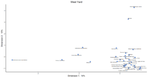
Figure 2. Plot of Ware Types along CA Dimensions 1 (Inertia 14%) and 2 (Inertia 10%)
As with other sites in the Archive, the seriation chronology for West Yard was derived from ceramic assemblages aggregated at the level of stratigraphic groups and individual contexts not assigned to stratigraphic groups. To reduce the noise introduced by sampling error, only ceramic assemblages with more than five sherds were included. We excluded assemblages from unit clean-up and surface collections. The seriation chronology presented here is the result of a correspondence analysis (CA) of ware-type frequencies from contexts that meet these requirements (Figures 1 and 2).
Prior to November 2020, there were no phases assigned to West Yard contexts in the database. After the addition of materials from DATA Investigations excavations conducted in 2016 to DAACS the CA results produced a strong correlation between Dimension 1 scores and MCDs (Figure 4), suggesting that Dimension 1 represents time from left (early) to right (late). Based on the dips in ceramic counts observed in a histogram of Dimension 1 scores (Figure 3), where the vertical axis measures ceramic assemblage size, we divided the West Yard into three occupational phases (Figures 4 and 5).
DAACS Seriation Method
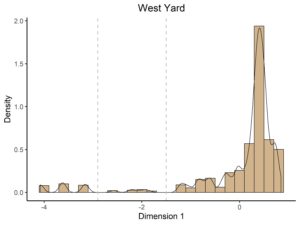
Figure 3. Histogram of ceramics from West Yard plotted along CA Dimension 1. The vertical lines indicate DAACS phase divisions.
DAACS Phases are groups of assemblages that have similar correspondence-analysis scores, similar MCDs, or both, and are therefore inferred to be broadly contemporary. Phases have a P-prefix that precedes the phase number (e.g. P01 equals Phase 1). Based on the correspondence analysis DAACS divided the West Yard occupation into three phases (Figures 4 and 5).
Mean ceramic dates for the site-specific phases are given in the table below. MCDs and BLUE MCDs, which give less influence to ceramic types with long manufacturing spans for each phase, indicate that West Yard was actively used for domestic and subsistence activities throughout the eighteenth century. The table also provides three terminus post quem (TPQ) estimates. The first TPQ estimate is the usual one – the maximum beginning manufacturing date among all the ware-types in the assemblage.
Two other TPQ measures included in the table below are less sensitive to excavation errors and taphonomic processes that might introduce a small amount of anomalously late material into an assemblage. They are TPQp90 and TPQp95. The TPQp95 of 1600 for phase 1, 1775 for phase 2, and 1820 for phase 3 provide a robust estimate of the site’s TPQ based on the 95th percentile of the beginning manufacturing dates for all the artifacts comprising it. The TPQp90 of 1600 for phase 1, 1762 for phase 2, and 1820 for phase 3 provide a more robust estimate of the site’s TPQ based on the 90th percentile of the beginning manufacturing dates for all the artifacts comprising it. The early TPQs for phase 1 are explained by the fact that the assemblages for the three contexts are mostly comprised of Delftware, which has a manufacturing start date of 1600.
Mean Ceramic Dates and TPQs
| Phase | MCD | BlueMCD | TPQ | TPQ90 | TPQ95 | Total Count |
|---|---|---|---|---|---|---|
| P01 | 1703 | 1710 | 1720 | 1600 | 1600 | 131 |
| P02 | 1729 | 1773 | 1775 | 1762 | 1775 | 47 |
| P03 | 1797 | 1795 | 1840 | 1820 | 1820 | 2288 |
Interpretation
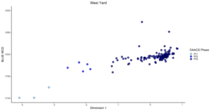
Figure 4. CA Dimension 1 scores for assemblages plotted against Mean Ceramic Dates.
P01 is solely comprised of contexts from F01, which is notably earlier than the other deposits found on site. Contexts assigned to P02 are a mix of deposits from UMW Unit 33, which was placed over the southwestern corner of Feature 01 and DI Unit 257, located in the eastern outer perimeter of the West Yard space. Archaeological investigations revealed that generally there was better preservation of older soil layers and features in the outer perimeter of the site. DI257 did contain part of a Builder’s Trench but was also disturbed by a pipe trench and some rodent burrowing. The majority of deposits from West Yard were assigned to P03. It is likely that no finer-grained temporal patterning could be discerned among these deposits because the West Yard area was heavily plowed and disturbed from repair and restoration work.
About the Code
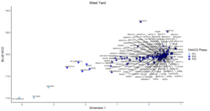
Figure 5. CA Dimension 1 scores for assemblages plotted against Mean Ceramic Dates, contexts, features, and stratigraphic groups are labeled
Incorporating data from the DAACS database, we perform the correspondence analysis through the R programming language (R Core Team 2014) to conduct the CA analysis. The CA code was written by Fraser D. Neiman. The following packages generate the data tables, CA, and plots within this code: RPostgreSQL (Conway et al 2013), plyr (Wickham 2011), tidyr (Wickham 2014), reshape2 (Wickham 2007), seriation (Hahsler et al. 2014), plotrix (Lemon 2015), ca (Nenadic and Greenacre 2007), ggrepel (Slowikowski 2019), and ggplot2 (Wickham 2009).
All of the R code used in this analysis was written within the domain of the R Core Team at the R Foundation for Statistical Computing, Vienna, Austria (2014). The correspondence analysis for West Yard was conducted by Elizabeth Bollwerk.
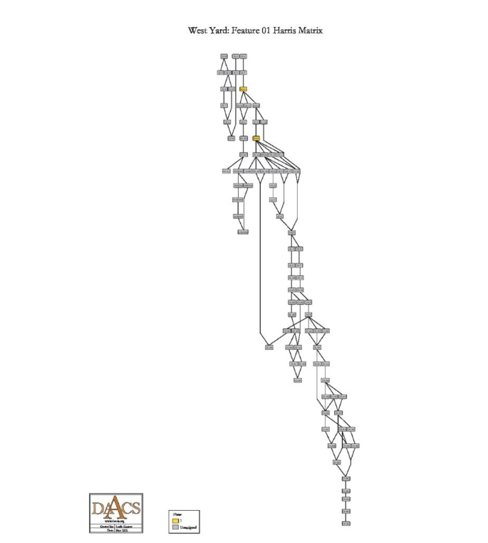
West Yard Harris Matrix
The West Yard was impacted by various activities that affected the stratigraphic analysis of the site. These include: 1) several archaeological campaigns beginning in the 1930s; 2) repair work in the 1930s to the exterior walls of buildings in the West Yard including the stables and the Southwest and Northwest Outbuildings; 3) plowing of the area as late as the 1940s; 4) trenching for utility installment; 5) and garden restoration work and ornamental plantings up until the time of the archaeological excavations led by Sanford in the 1990s. Though stratigraphic relationships among contexts are recorded in DAACS for all contexts where the information was recorded by excavators, a complete Harris Matrix for the entire site was not feasible due to the extent of the aforementioned disturbances. The general deposition of the West Yard area can be summarized as follows: mid-twentieth-century plowzone covers much of the project area that lies on top of a grid of 1930s archaeology trenches. Extensive planting-related features, as well as modern utility trenching, intrude the plowzone, which in some cases is topped by an incipient A horizon.
A major pit feature, Feature 01, is an exception to the basic stratigraphy described above. A full description of the feature is provided in the Background. Due to the complexity of the feature, a Harris Matrix is provided by DAACS that summarizes stratigraphic relationships among excavated contexts and groups of contexts that excavators and DAACS staff have identified as part of the same stratigraphic groups within Feature 01. Though Sanford and his field school students drew the east profile of Feature 01 outlining the stratigraphy between Units 33, 41, 42, and 43 at the end of its excavation, the drawings were not located at the time of reanalysis. As a result, only five stratigraphic groups were assigned by DAACSS based on information provided by the field records combined with photographs of the east profile: SG01, SG02, SG03, SG04, and SG05. Each of the stratigraphic groups represents a fill layer within Feature 01. Note that stratigraphic layers are numbered from the top down, beginning with SG01.
Stratigraphic groups and contexts are represented as boxes, while lines connecting them represent temporal relationships implied by the site’s stratification, as recorded by the site’s excavators (Harris 1979).
See the West Yard Chronology page for stratigraphic and phase information. Please note that some of the contexts present in the chronology analysis are not visualized on the Harris Matrix. The contexts that are not included do not have any stratigraphic relationships with other contexts. The lack of relationships can occur for a few reasons but two common examples are 1) the artifacts are from a surface collection, which is entered into DAACS as a context but does not have recorded relationships to other contexts that are below it; 2) in cases where topsoil and plowzone are stripped and discarded, there may be features below the plowzone that are comprised of a single context. Since the plowzone does not exist as a documented context with artifacts, it cannot seal the single-context feature. DAACS also does not record subsoil as a context, so there is nothing for that single context feature to intrude or seal.
This Harris Matrix is based on data on stratigraphic relationships recorded among contexts in the DAACS database for Feature 01 at the West yard. It was drawn with the ArchEd application. See http://www.ads.tuwien.ac.at/arched/index.html.
For a printable version, download the Harris Matrix [170 KB PDF]


PDF of West Yard site plan with excavated units labeled, compiled by DAACS using maps provided by Data Investigations, Inc. and John Milner Associates
PDF of West Yard site plan with features labeled, compiled by DAACS using maps provided by Data Investigations, Inc. and John Milner Associates
PDF of West Yard site plan with excavated units and features labeled, compiled by DAACS using maps provided by Data Investigations, Inc. and John Milner Associates
West Yard site map, delivered as shapefiles. Note that these maps are not projected into a real world coordinate system, but rather the local grid for the site.
West Yard site map, delivered as ArcGIS Pro project file. Note that these maps are not projected into a real world coordinate system, but rather the local grid for the site.
Armes, Ethel
n.d. Sketch of West Garden. Unpublished image available from the Robert E. Lee Foundation Archives.
Armes, Ethel
1936 Stratford Hall : the Great House of the Lees. Garrett and Massie, Richmond, Va.
Balicki, Joseph F., and Donna J. Seifert
1999 Archaeological Investigations in Support of the 1998 Conservation Program Stratford Hall Plantation. John Milner Associates, Alexandria, Va.
Barber, Michael
1997 The Vertebrate Faunal Analysis for the Stratford Hall Plantation Clay Borrow Pit. Unpublished manuscript on file with the Center for Historic Preservation, Mary Washington College, Fredericksburg, Virginia.
Beaman, Thomas E., Jr.
2002 The Archaeology of Morley Jeffers Williams and the Restoration of Historic Landscapes at Stratford Hall, Mount Vernon, and Tryon Palace The North Carolina Historical Review, Vol. 79, No. 3 (JULY 2002), pp. 347-372. Stable URL: http://www.jstor.org/stable/23522548. Accessed April 21, 2021.
Harris, Edward C.
1979 Principles of Archaeological Stratigraphy. Academic Press, London, England.
Neiman, Fraser D.
1979 Virginia Research Center for Archaeology Stratford Hall Survey Report
Sanford, Douglas W.
1996 Landscape Archaeology at Stratford 1996 Field Season. Unpublished manuscript on file with the Center for Historic Preservation, Mary Washington College, Fredericksburg, Va.
Sanford, Douglas W.
1997 Landscape Archaeology at Stratford 1997 Field Season. Unpublished manuscript on file with the Center for Historic Preservation, Mary Washington College, Fredericksburg, Va.
Sanford, Douglas W.
n.d. Draft Technical Report for West Darden Area
Sanford, Douglas W.
1993 Landscape Archaeology at Stratford 1993 Field Season. Unpublished manuscript on file with the Center for Historic Preservation, Mary Washington College, Fredericksburg, Va.
Sanford, Douglas W.
1994 Landscape Archaeology at Stratford 1994 Field Season. Unpublished manuscript on file with the Center for Historic Preservation, Mary Washington College, Fredericksburg, Va.
Sanford, Douglas W.
1995 Landscape Archaeology at Stratford 1995 Field Season. Unpublished manuscript on file with the Center for Historic Preservation, Mary Washington College, Fredericksburg, Va.
Shurcliff, Arthur
1930 Stratford, Virginia Report on Investigations and Observations Made in Regard to Brickwork and Mortar. Unpublished manuscript on file at Stratford Hall.
Shurcliff, Arthur
1937 Memorandum on the Supposed Orangery.
Smith, Michael , Alyson Andrews , and Douglas W. Sanford
1998 Stratford Hall Plantation: An Archaeological Assessment of the Innocenti Beds. Unpublished manuscript on file with the Center for Historic Preservation, Mary Washington College, Fredericksburg, Va.
Virginia Gardens, History
n.d. The West Garden. Electronic document, accessed January 14, 2016, (http://www.stratfordhall.org/plan-your-visit/gardens/history/).
Williams, Morley
1934 Weekly Excavation Reports